

6/25/23 Wilkes-Barre and Wyoming Loop with Chris "Cupcake" Kroschinski, Justin Gurbisz, Mike Heaney, Evan "Joe Millionaire" Van Rossum, David Adams, Brittany Weider, Robin Deitz, Heshi, Diane Reider, Daniel Trump, and Everen
This next hike would be a long loop in the area of Wilkes-Barre and Wyoming Valley along the Susquehanna River.

I had done a really fun hike that included some of this section not so long ago, but we had started farther north, and it was a point to point. This time, we would begin and end at Kirby Park, where we'd done a few hike connections somewhat recently.
We had done the last hike in the D&L Trail series ending there last year, as well as the other along the Susquehanna from the east.
I decided to do this first of all because Cupcake had moved to coal country recently and it would be closer for him, but also because I wanted to move on another series following the Susquehanna River both up and down stream, tracing rail beds as well as the historic route of the Pennsylvania North Branch Canal.

I'd done some of the canal route into Wilkes Barre, and another bit further north toward Pittston, but was missing big segments.

My plan was that we'd do this and another loop to the south of this one, and then continue tracing the canal route down the Susquehanna into the Winter.
I wanted to try to trace both the Pennsylvania Canal, as well as the railroad beds that were close to the river.
The route on the way out would include not only the historic canal route, but the former Central Railroad of New Jersey Canal Branch, but also parts of the Lehigh Valley Railroad and the Laurel Line. The return route on the other side of the river would be mostly trail on the flood berms, but have plenty of other interesting things as well.

We passed through the park on improved surface trails, past some enormous trees. It was a very pleasant walk, past the nice little ponds, and then out to the Market Street Bridge.

We turned right and crossed the bridge, which is the northern terminus of the D&L Trail. Last year, I did a hike that took us to this point after years of working on that.
Kirby Park is on the Kingston side, but technically part of Wilkes Barre, but we crossed the bridge to the Kingston side of the river, and then descended to the walkway area along the river known as the River Common.


We began walking to the east, and there is a sort of amphitheater known as the Millenium Circle to the right. It was all quite pretty.

We continued to the North Street Bridge and had to ascend to Water Street and it was in this area that all of the transportation corridor history came flowing in.
The court house building and its associated complex buildings is built on what was a basin on the canal, known as the Redout Basin.
The North Branch Division of the Pennsylvania Canal ran 169 miles from Northumberland, along the North Branch of the Susquehanna River, to the Junction Canal of the New York State Canal System.

The first section from Northumberland at the West Branch Canal to Nanticoke, 55 miles in length, began in 1828 and was completed in 1831.

The section we reached here was known as the Wyoming Extension, 17 miles more through Wilkes Barre to Pittston. The final 96 mile exension from Pittston to the Junction Canal was started in 1836, and completed in 1856, by which time the canal was already pretty obsolete.
The North Branch Canal had a total of 43 locks that overcame 334 feet of elevation .
In 1858, the state sold the section of the canal from Wilkes Barre north to the North Branch Canal Company, which sold it to the Lehigh Valley Railroad in 1865.

The railroad laid tracks along portions of the canal towpath, and operated both until 1872 when it was authorized by state legislature to abandon the canal.

Also along this corridor was the old Laurel Line, officially the Lackawanna and Wyoming Valley Railroad.
This was a third rail interurban railroad that operated between Scranton and Wilkes Barre carrying commuters from 1903 to 1952, and freight until 1976.
The line was built and owned by Westinghouse, Church, Kerr, and Company, a subsidiary of Westinghouse Electric & Manufacturing Company. Westinghouse interests controlled the railroad until 1914.
 |
| From "Frank's Rail Fan Page" |
The electric aspects of this line were taken out of commission in 1953 with the rise of deisel engines, and it was purchased by the Delaware, Lackawanna, and Western Railroad in 1957.

It continued to operate independently from the that line and the merged Erie-Lackawanna, until they were both included in Conrail in 1976.
Much of the line was abandoned after that, and even obliterated, while other sections remain in service for both freight and passenger use.
The two lines occupied a close proximity, and there was a River Street Stop on the interurban at about the point where we came out. There was no evidence of the canal or either rail line at this point.

The Luzerne County Courthouse was built in Classical Style in 1906-09 on the site, but that coexisted with the two rail lines.

We crossed North Street, and continued on Water Street close to the Susquehanna. There was a fenced off area to the left where Wilkes-Barre Gas Works was, and a path alongside it to the left. I wasn't sure if we'd be able to get through, but it was a good path out along the edge of North Street, so we headed out. It was somewhat tougher getting the stroller in there, but I managed.
This took us out to a good view beneath the road bridge, but there was no way to get through to the right, and no visible remnants of any canal here. I think the canal was located right along the parking area, now all filled in.

The Lehigh Valley Railroad, for which I found this labeled as the Harvey's Lake Branch, was also in what is now parking next to Water Street.

I think the branch was the one later referred to as Bowmans Creek Branch. I had been referring to the line on the other side of the Susquehanna as such in the series Id been taking to follow it, but maybe this was part of it, or known as a different branch in later years. I'm not really sure.
As far as I can tell, the Laurel Line was directly in Water Street at this point.
To the right of us, we passed the old Reichard and Weaver Bottling House.
The company closed down in 1920, but the building still bears the names. Reichard family operated the brewing company from 1833 to 1897.

We continued through the parking areas, which made walking along easier, and then shifted to the left.

There was soon a sort of ATV path that led away from the end of the parking lots from Water Street, and followed all of these rights of ways, which shifts around quite a bit at this point.
The Lehigh Valley Railroad served the Lehigh Coal Company's Dorrance Breaker and Dorrance Colliery just ahead, which is off what what is now Courtright Street, the same street as Water Street only it changes names. That line shifted to several tracks in this area. I saw what might have been canal berm, and was probably extra trackage. I feel they probably laid track in the canal after abandonment.
The ATV path we were following probably followed most closely to the Laurel Line at first, because it was the one closest to the river at this point. It crossed over the Lehigh Valley line here.
I had hiked this bit once before, on a hike on the Bowmans Creek Branch several years ago to end at the lot just above this point, but I didn't have a whole lot of information on what I was seeing then, and I missed some really important key items, so I was glad to walk this piece again.
We hiked just below the Hollenback Cemetery, and then reached the crossing of the Mill Creek.
Of course, this was three major transportation corridors that crossed in this one spot, and it was an impediment each had to get past.

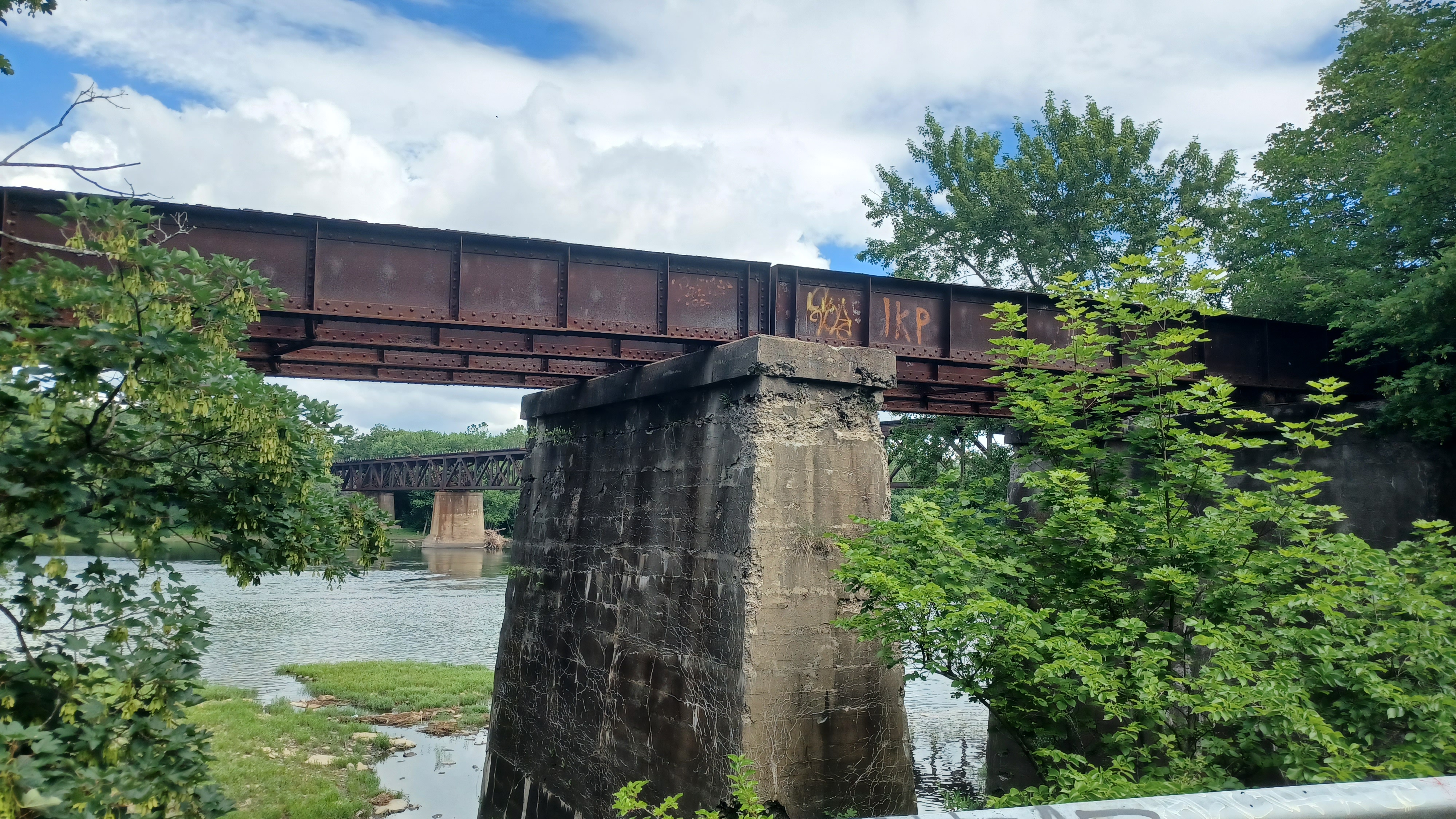
We crossed on a bridge that occupied the former Lehigh Valley Railroad bridge site, but this was obviously not how it always was.

Directly to the left of us, and higher up at this point, was four sections and two spans of deck girder bridge that carried the Laurel Line across. To the right of us, there were old stone abutments that I assume was probably the original Lehigh Valley Railroad right of way from when the canal was in service.
When I got across the bridge and waited, I looked down to inspect the bridge we crossed, and it was obvious that this bridge was built directly on top of the old canal aqueduct abutments.

The recess in these abutments that would have held the trough for the water had been filled in by more cut stone, and the newer bridge placed on top of the improved abutments.

The fine cut stone of the aqueduct with its curved edges was in amazing shape considering it had been there since the 1830s.
Just ahead, we had to ascend a bit in a way a railroad never would, apparently because Waterfront Orthodontics and other businesses had filled and been built over the rights of way. At the top of the hill, we passed beneath the bridge of the Wilkes-Barre Connecting Railroad, known as the Mill Creek Bridge.
The line was joinly leased by the Pennsylvania Railroad and Delaware and Hudson Railroad, and the Wilkes-Barre and Eastern had trackage rights. The McDonalds next to the Orthodontics place up the road was a end point on one Bowmans Creek Branch hike, and the Wilkes-Barre and Eastern hike because of this pinch point.
The Wilkes-Barre Connecting Railroad was a subsidiary of the Wilkes-Barre and Eastern and became an independent entity in 1915.
We continued under the bridge and past the orthodontics place, then out through the lot behind the River Grille. We headed down some steps or something behind the place where there is more waterfront seating and views of the river, but there was no good way through that way, so we had to backtrack around the building and through the front past the McDonalds.
The Laurel Line went right through where the River Grille is, and then crossed over the Prospect Viaduct over another branch of the Lehigh Valley Railroad that came in from the right, tracks still in place and active today I think under Reading and Northern, as well as the Canal Branch of the Central Railroad of New Jersey closely parallel.
The CNJ line was built originally by the Lehigh and Susquehanna Railroad, a subsidiary of the Lehigh Coal and Navigation Company, in 1862. It was leased to the Central Railroad of New Jersey in 1871.

This was a busy area as well, because on the slope just to the right of us and behind River Street was the site of the Prospect Breaker, Prospect Colliery, and Prospect mine shaft. That entire area is a disturbed, undeveloped spot today.
The Laurel Line shifted off to the right of River Street, and served the Midvale Breaker, then continued further inland beyond that, so we didn't see it again.
We continued down a slope where the viaduct would have been, and there was some stream infrastructure stuff down along the active tracks that was sort of daylighted. It is hard to say what all of this was. We continued on an ATV path that paralleled the tracks to the northeast.
We continued ahead and passed beneath the Cross Valley Expressway, which had two twin bridges. In this area, the Lehigh Valley Railroad had a spur that went up and paralleled another CNJ spur, the Prospect Breaker Branch.
After the Cross Valley Expressway bridge, the Canal Branch veered to the right a bit into some wooded land, and the old North Branch Canal used to be right next to the active railroad tracks, which we followed ahead to a small clearing of grass to the right.
We went uphill into the parking lot beyond, which appears to be filled up over where the CNJ line went. There was a bakery in this lot, as well as a Subway and other stuff, followed by a day care center that might occupy a former school house. These lots were formerly the site of the Hollenback Colliery.

We continued through the parking lots here. We didn't want to be walking the active railroad tracks there, and so the lots we walked through were pretty much the Canal Branch of the CNJ for a while.

We meandered back to a veterinary referral center, where there were advertisements for neutering, and some of the group split off from time to time in this area to get different kinds of food and snacks.
It was really brutally hot out, and so any shade and comfort we could find for a while was good.
At one point, I had to wait in a small line of trees between businesses for everyone to get back together. Some of them also went out to River Street and walked around the lots because we got so separated.
 |
| Laurel Line Prospect Viaduct |

We reached Gallagher Drive, which crossed the lots and the railroad tracks beyond. Near this spot was the site of the Wyoming Shaft.
We turned left along the road and crossed over the railroad tracks. The road turned ninety degrees and paralleled the tracks. This was just about the southbound junction with the Bowmans Creek Branch, where the line turned left and headed west to cross the Susquehanna River on the Port Bowkley Bridge.
The Bowmans Creek Branch was apparently abandoned on December 22nd, 1963, but this bridge might have been abandoned a bit earlier. Timetables apparently show that the last trains across the Port Bowkley Bridge were in 1932. When the bridge was removed, the piers remained in place for a number of years later before being blasted away.
We continued down the road, and I didn't see the north leg of the wye where the Port Bowkley turn was.

I had wanted to follow this road because I saw that out in the woods on the aerials there were a bunch of ruins. I figured it might be cool, and there were no impediments so far.

It seems that the road likely follows what was the towpath of the North Branch Canal, so that was cool also.
We continued along the road until it started to turn to the left away from the tracks. There was a small area of water to the right around this point, which might have been a canal basin.
The road was full of deep potholes, but I was able to push the stroller through it all pretty well.

As we reached the destination on the road, we came across a large gate with lots of no trespassing signs. I decided we wouldn't try to go through, and just turn back. I didn't want to have any kind of problems.

As we were heading back, there was a vehicle coming straight toward us, so I decided we'd use the next cut through to the left to get out of this area. The vehicle ahead would be going slow through the potholes, so I figured we might get out of there.
I got Ev down the slope, into what must have been the canal with a little wetness in it, and then up the other side to the tracks and across to the other side.
The two guys in the vehicle reached some of the others before they got off of the road, and Dave sort of took the lead I understand talking to them.

They let them know the gate was why we turned back when they said it was private property, and that we were just trying to trace the old canal. He then asked "may we pass" and they were nice enough to not bother with us any more, and we all cut down and across the tracks.

There were a couple of small bodies of water to the left of the tracks that might have been parts of the old canal ahead, but then the historic route of the canal turned to the right away from the tracks. We continued along the tracks, and the Canal Branch of the CNJ also continued away, parallel with the canal, but there were no obvious remnants of either. Aerial images seem to suggest the old canal route is now a sort of woods road that comes out to May Street off of River Street.
Parking lots off to the right from the tracks in this area were formerly the site of Henry Breakers and Henry Shaft. This was also a part of the Port Bowkley yard on the Lehigh Valley Railroad.

Of course, Port Bowkley must have been a substantial location for the canal as well, but I don't know much about it.

I don't know where any of the locks were on this section, and they didn't seem to show one on the historic atlas maps of this area, but those are often missing on these maps.
We continued on the rail line across a farm access and continued ahead. There was a side ATV path to the right that got us off of the tracks for a bit, so we followed that to the right, which remained closely parallel. I figure it might have been a second track or earlier alignment.
As we continued ahead, someone came across the farm access driving. It was apparently the folks that had seen us before, probably just checking up on us to make sure we were going where we'd said we would. They didn't continue to follow us further.
 |
| Dorrance Colliery |
We continued ahead and crossed over McCullough Road. Dave helped me to push my stroller while I walked with Ev or carried him.

Parallel with us, where the old canal and Canal Branch came out to River Street, there used to be a Burroughs Colliery and Burroughs Shaft, both abandoned before 1884.
The canal becomes one with River Street, and the Canal Branch paralleled it to the right, and we were on the tracks just a little further ahead to Courtright Street.
There was a strip mall on the corner, where there was Purfect Mugs Cat Kitchen, a cat cafe. We walked in and looked around, because being in a cat filled place is wonderful, but we really didn't have the time to spend or the money to pay the cover to only spend a short time, so we moved on.

We did take a short break in this area, and Dan met up with us at this point! At first, it was a surprise that he'd gotten the day off at all and could come out with us.

He's always so busy with his railroad and the York Heritage Trail where he's sort of the engineer and head mechanic for the locomotive, he just never is able to get weekends off and misses it. It was great to see him back out again. He lost a bunch of weight because he's been working so much.
At some point, someone spotted a Dobsonfly on a wall of a building. I remember hearing a couple of "what the hell is that" stuff. A Dobsonfly is the adult version of a hellgrammite, and they look like the hideous lovechild of a praying mantis and a brown moth.

We continued along the road ahead, and there was a big ditch to the right side of River Street, which must have been some sort of remnant of the canal.

The former Lehigh Valley Railroad came close to River Street just inside the woods to the left, and the Canal Branch of the CNJ continued on the right until we got to the intersection of Saylor Avenue.
This was a significant point, first because it was known as Port Blanchard. Maybe there was a lock here, but I saw nothing of anything like that.
Later, this was known as Plains Junction. It was where the CNJ Canal Branch ended, and met up with a branch of the Erie Railroad that went from this junction to Avoca. It was built in 1884 as the Erie and Wyoming Valley Railroad and then became part of the Erie.

Soon ahead, River Street, still the former route of the North Branch Canal turned slightly and crossed the former Lehigh Valley Railroad. At that point, the Erie line moved off to our right a bit, and there was a junction with the #14 Breaker Branch, which served a coal breaker of the same designation.

We didn't continue ahead on the road, but rather cut through grass to the left and across the tracks to an old cemetery I had planned to check out when I planned this.
The Cooper-Blanchard Burial grounds, established 1794, is just a little to the west of Pittston. We walked a bit through the grounds and checked out the old tombstones, and then continued closer to the river on the access road, which goes out along the edge of a private home.
The north section of the home seemed to be an old frame house, and I wondered if it might have at one time been a lock house or canal related. I looked it up on the historic atlas maps, and that noted that it was a Cooper family home.

There was a newer addition on the south side of the building, which was recently badly damaged by fire, and it looked as though no one was living in either section of it. At least the old section of it looks to be fine.

We continued ahead just a bit more onto River Street, and I recall that some of the plans I'd had for places to eat were not open. I know I ran into some store along this stretch, but I don't recall exactly what I'd gotten there.
My original plan for this hike was that we might continue all the way to Pittston and then turn back, but based on the time of day and the fact that we'd already done about half the fifteen mile distance we usually try to do, I decided we would have to cut this a bit short and head back at the 8th Street Bridge.

Cupcake had brought some stuff for historic notation on the Knox Mine Disaster, which had happened just a little to the east.

He wanted to go to the site, and was still willing to do exta mileage, but even to go to the Knox site, it would have meant going a bit further ahead than I really wanted to.
Fortunately, Mike Heaney chimed in that he didn't want to do that much extra mileage as well. It was a good thing, because it would have been too overboard.
At about the spot where we turned to cross the bridge, the parallel Lehigh Valley Railroad had its Port Blanchard Station. The canal remained on the road ahead from here, and approached Port Griffith.

There were good views of the Susquehanna from the bridge, and when we got to the other side, there was some pipeline work going on. It would be great if this pipeline right of way turned into another trail project in the near future when complete.
We reached the community of Wyoming on the other side, and there was a US Gas on the right side. I went into the place, which sold booze, and I got something in there. I think it must have been a Four Loco or something for the first time in a while.
We turned left and followed Susquehanna Avenue to the west through neighborhoods. We continued along to the next intersection, and turned left to continue on Susquehanna Ave.

We took a little time to read the stuff at the monument before moving on ahead.
Wyoming Avenue, Rt 11, took us to the west from here, and had some shade for the first bit.
It wasn't very long before we came to the eastern end of the Luzerne County Levee Trail, a flood protection berm system that runs most of the way from here to west of Wilkes-Barre.

I had walked much of this before, on the hike we had done the previous year, but that time we bushwhacked a bit along the river beneath the next bridge, and this time we'd see a few more different things.

It was brutally hot for this bit, out in the wide open. Fortunaely, I had sunscreen for Ev, but he was at the point that he was still unwilling to wear a hat, so I had to make sure he was protected pretty well.
This was the first safe spot in quite a while where I could let him out of the stroller, it was just not enough shade.
I let him out, and he immediately started running along, happy to be out.
I picked him up after a bit, because it was just so hot and his face was getting red from exertion. He wasn't complaining and wanted to go more, but I could tell he was getting tired. I didn't want him getting dehydrated.

We had matching tie died shirts for this hike, so it probably looked kind of cute while I was holding him.

We paralleled the airport to the north of us for a bit, and had some wide open views of the Susquehanna, and also skirted a cemetery below for a bit.
When I saw an opportunity to go lower from the paved path on top of the berm, I took it. There was a good section of shade trees in the grass below to the left, so I took that opportunity to go up.
I asked Joe Millionaire to stay with Ev in his stroller for a moment; I pushed him back up to the top of the berm, but wanted to go back down and just lay in the Susquehanna for a few moements.

There was a point of a drain or something with some rocks that I couldn't resist getting in. I think it was the spot where Abreham's Creek flows beneath the berm and out to the river. I felt much more refreshed after that and we continued on.

Through this section, all of the bad forecast stuff we dealt with, and we were in the sun, totally clear, but could see that in areas all around us it was pouring.
Downstream on the Susquehanna, we could see dark clouds, and the darkness reached to the ground, which of course means precipitation. To the south of us, it was also raining pretty heavily. To the west, there were also clouds. It seemed like everyone around us was getting worse weather than us.
Pretty soon, the trail started following a tall wall on the right as we approached neighborhoods in the town of Forty Fort. This is a settlement so named because in 1770, forty settlers from Westmoreland, Connecticut set up a fort here along the Susquehanna. Prior to the American Revolution, both Connecticut and Pennsylvania laid claim to the territories, which triggered much colonial strife.
We continued along the path, which afforded outstanding views up ahead at the bend in the Susquehanna toward the Cross Valley Expressway Bridge. Prior to that, I was surprised that the water was low enough to see the footings of the piers of the Port Bowkley Bridge. Often, there is nothing at all visible remaining of this bridge site.
The paved path eventually turned to the right, up and over the flood berm, to River Street in Forty Fort, near an historic marker about the history of the town.

From here, we had to continue to follow the street to the north. Dan was really wanting to head inland more and hike the parallel old Lackawanna branch that passes through, which I also wanted to do, but I also wanted to save that for a future hike more in that theme.

We passed where the Lehigh Valley Bowmans Creek Branch used to cross the road, now barely recognizable because of all of the yards over it, and then made the next right on Rutter Avenue.
We continued a short distance, and then cut through grass to the right and into the parking lot for the local hospital. The Lehigh Valley line used to go right through this parking lot. We continued through it to the west a bit, and then out across Welles Street, and it seemed evident that there were still rails in the roadway beneath the recent paving jobs.


To the left, there is a large old industrial building that has been re-purposed as a restaurant known as The Canning House, which looked like a cool place to stop for lunch.

I think both Dan and Cupcake were averse to going there because it was sort of upscale gentrified, almost like it was too good for everyone, but I really did think it was cool so we went for this as our lunch stop.
In this case, although they may be right about other nearby places being better, both the food and service here was very good. The girls that were waiting on us were friendly and fun, and the burger I had was great.
I also made sure to make Ev drink tons of water, and gave him plenty of ice cubes to get him through the remainder of the hike. This was definitely a needed stop.

The place was also full of all sorts of old retro stuff, what seemed like World War II posters, art displays, etc.

It was all just very busy and interesting. It seemed odd because everyone was in sort of one area, but there appeared to be a ton more under-utilized space in the building. I took Ev off to the restroom to change his diaper, and meandered looking around a bit.
We got our group shot on the way out from here, and then had to head south. Apparently, Rutter Avenue used to continue on what is now the south side of the parking lot at this building, but it was re-aligned when the Expressway/Rt 309 was put through. We had to go up a rather steep grassy hill and then onto the current Rutter Ave alignment again, then crossed the bridge over the highway.
 |
| Historic view of Port Bowkley Bridge |
On the other side, we reached Church Street and turned left to cross the road. The Luzerne Levee Trail started back up immediately on the other side again. I let Ev back out of the stroller, and he continued to run ahead happily.

Immediately to the west of this section of flood berm trail was the site of Pettibone Breaker, now all housing development. The Lackawanna Railroad had its own Pettibone Branch that served the site from the north, and the Wilkes-Barre and Eastern had a spur that served it from the south. The right of ways were between Joseph Street and Lathrop Street.
We headed south on the berm for a while, and then it shifted to a southwest direction, and passed by the the Kingston Public Works department, just before passing beneath the Wilkes-Barre Connecting Railroad bridge again.


In this stretch, I continued to allow Ev to walk on his own, but he was obviously getting tired in the heat, so I had to watch close. In addition, he is constantly distracted by anything and everything. A rock or a stick, he has to pick it up. He still loves throwing them into the water, and even when it is not known when and if we may be crossing a body of water, he still wants to have ammunition to be ready to throw.

When Ev started running a bit behind us, pausing a lot, I would wait just ahead. "C'mon Ev!" I'd say to him, and usually he'd hurry up a bit more, or otherwise take his time with his distraction.

Robin was walking near the back of our section of the group, and she turned around and walked backwards to talk to Ev more easily.
"C'mon Ev, walk this way!" she said to him. Ev looked up, turned around backwards, and tried walking that way! It was one of the most hilarious and adorable things I'd seen in a long while.
We continued along the path, and when we were near the Kingston Recreation Center, there were paved paths going down the berm in both directions.

When it looked most feasible, we took to the trail downhill to the left, into Nesbitt Park. This was a really pretty section because it had some more enormous trees, the first couple Silver Maples, and then Sycamore.

We passed beneath the North Street Bridge, and then continued on through the grass in this nice and shady park to the Market Street, bridge, where we were afforded some different views of the bridge and the buildings including the court house on the other side.

From here, we had to go up to the levee again, because we had to get back down the other side again to get to our cars.
Once we got to the top, we headed right back down the other side, and I think I recall Dave continued to help with the stroller, which was a bit of a chore going down the grassy steep hill.
We all headed over to the playground area, and took a break where Ev could run around like a crazy boy.

There was someone playing with a large professional RC car out on the pitching section of a baseball diamond, so we watched him for a little bit.

Ev was so incredibly excited about this little truck that he would clench his fists and make all sorts of crazy sounds of excitement!
The clouds were moving in fast; I think they were calling for rain and none of it ever came. I was counting on at least a bit of cloud cover, which was one of the reasons we did the route we did, but it ended up being brutally hot and humid.
This last stretch started revealing some very dark clouds on the horizon just to the south, over Wilkes-Barre.

The rest of the group started making their way out until it was pretty much just John and I still hanging out. Ev played around on some of the playground equipment at Kirby Park for a bit, and he and I were the last ones out.


It really worked out well that we had cut short from where I was originally planning, or we'd have been much later, which meant we would have been out in a storm.
The clouds were getting darker, and soon after I got Ev in his carseat and started driving through Wilkes Barre, I started feeling droplets.
I felt really good finishing this one, with a relaxing drive back home. I even made a pit stop and set up a history compilation at Bear Creek Village of the old station on my way home.
There is so much to do through the area we walked, so many more abandoned rail lines, so many parks, the canal, and I can't wait to do it all.

No comments:
Post a Comment