

Hike #1530; 2/12/23 Harmony Ridge to Phillipsburg with Professor John DiFiore, Violet Chen, Diane Reider, Jennifer Berndt, Jill Gamble Gupta, Koshek Swaminathan, Lerch (Michael Clark), Cara Ashley, Serious Sean Dougherty, Ken Zaruni, Justin Gurbisz, Eric Shubert, Dan Lurie, Samanthan Lynn Schosselberg, and Everen
This next hike would be one that I planned as a point to point near home in Warren County. The reason for this one started because Brittany had wanted to have a party that weekend, plus it was originally planned to be Jenny's last hike with us until her family made other plans for her, so it would be good to be close.

There were new sections added to the Morris Canal Greenway, so I was keen on doing those as part of a hike, as well as a couple other things I hadn't done in a million years, so I knew it could be great.
I meandered with Ev a lot on Saturday, and went to visit my dad and stop mom for dinner with him, which was a nice time. On my way home from there, we stopped by Brittany's, because it would be the last chance I would get to see Jenny before she left.
I hung out for maybe a half an hour and Ev played with some balloon machine stuff with Justin. I wanted to be sure to get him to bed by 9:30 so he would be ready for the hike in the morning.
I showed up at the meeting point, which was Riverside Park in Phillipsburg, directly on the former Morris Canal, and some of the group was having trouble finding the location because GPS would send them to the wrong spot.

Once we had everyone together, we shuttled up to Brittany's house on Ridge Road in Harmony Township. We went inside and hung out a bit before we got started.

I was impressed that the group was up and ready to go. I had stopped doing my own parties the nights before hikes because it would mean that no one would end up hiking, because they were all too hung over or whatever. This time was definitely an anomaly because everyone was doing so well.
From the driveway, when everyone was ready, we simply started walking Ridge Road to the west a short distance. The Warren Highlands Trail crosses the road within sight.
Samantha had only hiked with us once before many years ago, and so this was her first time after all sorts of medical work trying to do any distance at all. She did cover a little distance from the start to Harmony-Brass Castle Road, which was great that she gave it a go.

As we started, I realized that I'd forgotten to grab Ev's bottle, and I didn't want to spend the day trying to get him to drink out of a bottle, so I ran back to get it while the group pushed the stroller ahead.
I cut to the left across state park fields to cut the corner, and didn't realize that some of the group was waiting for me at the turn. When I got to the Merrill Creek Reservoir's pumped storage facility pipeline access and my son and much of the group was missing, I had to run back to see them there. Pretty soon we were back together though.
I told the group they should head up the hill that the pipe access was buried in for good views in all directions before we moved on.

The trail from this point pretty much follows the pipeline, which at this point also doubles as a farm access. We dipped down to a muddy area and crossed a small tributary. I think this one might actually flow into the Buckhorn Creek to the east rather than the Lopatcong.
The segment was super muddy, but we pushed on through it anyway. It was hard getting the stroller through.
We headed up through more fields, then to the right into the old Miller Farm, which has a remaining corn crib, silo, and beautiful stone barn skeleton without a roof.

We continued from here on out to Harmony-Brass Castle Road where the trail crosses to Merrill Creek property. Dan hung back with Sam to make sure she could get an Uber out of there, and then would continue up the utility clearing to follow us.

We descended on the pipeline, and the trail cuts to the right into the woods for a bit when the Lopatcong Creek is reached. Several years ago, I built a bridge over the creek with Matt Trimmer here, using tools lent by the late RJ Strunk. Unfortunately, that bridge has busted up and no longer exists, save for the one board that I had chained to the roots of a tree on the far side.
Lerch managed to find that board and chain, and pulled it across the stream so that we could use it to somewhat balance across. I didn't have to do aything in particular because it was so shallow on this occasion. I just walked Ev across the thing and then up the other side.

This would have been a problem, because I had had problems with the stroller front wheel going flat, but fortunately Brittany had a bicycle tire pump I could use when we started, and so I made sure we had enough air in it at the start. I did happen to forget my cap for my wheel on her kitchen floor though.
I had never tried to push the stroller up this hill before, and it was really very rough.
I waited for a few moments for the others to get through, and observed a large spring flowing from the right of the trail, adjacent to the pipeline.

I noted some possible disturbances along the edge of the spring which meant it might have been altered for collecting or something by either natives or colonists. It would be interesting to know for sure.

I started pushing steeply uphill, and it was a real killer workout to get the stroller up. None of it was really difficult on the wheels or anything, just pushing up the steep incline was a huge workout.
I kept going as best I could while Lerch egged me on a bit. I really broke quite a sweat for this short distance where it normally would have been easy for me.
We reached the point where the paved access road reaches a building for the pipeline and held off there for a bit for the rest of the group to catch up (that's right, despite this extra weight, both on my person and in my stroller, I still was one of the fastest up).

We could see Dan and Sam coming to the road below and sitting on the railing at the parking area near the kiosk on Harmony-Brass Castle Road. A truck pulled up, which we assumed might be the Uber for them, but it wasn't. Dan was going to get just that though.

Once Sam was in the Uber, Dan's plan was to head up the mountain and catch up with us. I gave him the idea that rather than try to follow us around the reservoir the way I was going, he could stay on Warren Highlands Trail to the south a bit, then remain on the Perimeter Trail to the main dam to catch up with us and cut a bit of a corner.
We continued up the road a bit, and came to the old intersection where the service road hits what used to be Allen's Mills Road.
We paused here, first of all because I was certain Ev needed a diaper change, and because I wanted to go over some history as well as give Dan a little time.

Ev actually only peed, so it wasn't a major diaper disaster.
I told everyone of how Allens Mills Road used to continue to the small settlement of Allens Mills, which is located a little over a mile to the west on Harmony-Brass Castle Road from where we crossed. There are remnants of the dam berm over there to this day, and the miller's house is still standing.
I wonder if the Allens who ran the mill were relation of mine, because that's my grandfather's last name and lineage. I could only trace the Allen family back as far as Michael Cline Allen in the 1800s in Delaware NJ.

Before the reservoir was built, Allens Mills Road continued from the small settlement of Montana to the east of the reservoir, past Richline Road, and then made its way downhill to the mills.

The reservoir was built over a portion of Allens Mills Road, which was cut off from Harmony-Brass Castle up to the the reservoir, and used in part as the service road, and Fox Farm Road, which intersected, was extended in name from the intersection with Richline Road west.
Many people get confused on this because currently, Allens Mills Road ends at Richline, which is nowhere near Allen's Mills.
We continued uphill on the old Allens Mills Road, then continued from there up to the entrance to Merrill Creek Reservoir and the parking area at the hawk watch.
Everyone started heading along the Warren Highlands Trail route with the blue blazes, but I had to let them know we would be going the other way across the spillway and the last dike on the reservoir.
This was easy enough at first. There was a bit of a view from this point near the top of Scotts Mountain, then a nice walk over the spillway and around over the dike.
From the top of the dike, I was able to point out to everyone where Allens Mills Road used to go into the reservoir, and how a portion of it is now used as the perimeter trail over on that side. We got across the dike, turned right on a root covered trail, and then turned left on the Perimeter trail, which was super easy for as far as it followed the old road.

This next bit was the hardest stuff on the entire hike. The trail was much of the time covered in tree roots, and while I was able to push on through it much of the time, I required assistance much of the time to carry one end of Ev's stroller to get him over it.

We continued through on the Perimeter Trail to where Merrill Creek flows in as the main feeder of the reservoir. The trail followed the edge of the creek on a very narrow shelf for a bit, which required that I held the stroller so that one rear wheel was off of the ground at all times. The I needed help to get the stroller up onto the foot bridge over the Merrill Creek.
At the other side, there are some woods roads, so that made things a bit easier. My original plan was to follow the immediate perimeter of the body of water, but I decided we would take an easier route through because the previous section had been so difficult.

We turned to the right after the bridge just a bit, on the blue trail, and when that continued ahead along the shore I didn't want to get in any more trouble with rough terrain.

The blue and yellow combined to the left went gradually uphill and seemed to follow some better old woods road. This was definitely the way to go, and I don't think I had ever brought a group through on that route yet.
We continued up a slight hill, and through pleasant woods for a bit, then descended somewhat back to where the blue came in from the right. We paused at the intersection, and I pointed out a stone ruin straight ahead was a lime kiln. I recognized the spot and encouraged the group to go right and have a closer look at it while I got some snacks out for Ev. He munched on some cheddar cheese and such as we waited, and started falling asleep despite the somewhat rough terrain.

We continued on the blue trail, which had been nicely done with paint blazes, the correct way. I think this was the work of Tanya Sulikowski, who had been working at Merrill Creek until recently, and helped me to blaze the Warren Highlands Trail through the properties. She told me she was going to fix the blazing, and it looked pretty good, so it must have been her.
Soon, a barn foundation appeared on the right. This was the Cathers/Shafer barn site. Also in the area and below to the right was a former farm pond, now just a little marsh closer to the reservoir.

A little further ahead, the trail went onto a board walk that was almost completely covered in much and such, but solid enough that we could get across it. The springs that fed the wetland emanated from an old spring house that is still standing to the left of the trail.

Just ahead a bit more, the foundation ruins of the Cather farmhouse was on the left. We continued straight on the red trail for a bit, which followed an old road for a bit, and when the road went down into the water, the trail turned to the left on a foot path to follow the shore.
This wasn't as bad as the last section we had been on, but it wasn't easy either. We got through it, and pretty soon came within sight of the visitor center. We made our way into the clearing, and then up and around the back of the building.

It was an incredible relief that we were finally done with the really rough terrain. Pushing the stroller was incredibly easy, and I was looking forward to potentially using the restroom and visitor center for Merrill Creek.
When we got around the building, the visitor center had a sign reading that it was closed until further notice. I suppose it may never have opened from the pandemic, but I'm not sure.
We hung out for a few moments at the visitor center, and I got in touch with Dan to make certain he was on the correct trajectory.
We all started moving along the Perimeter Trail, which had one more sort of rough section to get down from the visitor center to the boat launch, but it really wasn't at all bad. We crossed the foot bridge at the bottom, and then crossed the parking lot for the boat launch, which was quite busy.
Serious Sean decided he was going to cut out at this point rather than continue; he'd been up much of the night partying at Brittany's place, so that was understandable that he wouldn't want to push too hard. Koshek also decided he was going to cut out early at this point as well.
I wonder what the future has in store for Merrill Creek. The pumped storage facility only has one remaining function turbine in it, and such pumped storage facilities, like Yards Creek also in Warren County, are not generating the electricity needed for modern day.

There had been talks over recent years of Yards Creek closing, and with the news that only one turbine works at Merrill Creek, and the fact that it is literally making now money for the consortium of power companies that own it, leads me to believe it will be turned over to a government agency.
Based on no news from any management of local governments or friends at Merrill Creek, my assessment is that it will eventually transfer to a government agency, and that Warren County will averse to taking on the reservoir because it has five dams. We couldn't even purchase a watered section of the Morris Canal because it has one dam, which is why I feel this way.

Time will tell what will happen, but if it were the state, it would mean creating an entirely new state park, because the place gets more visitation than any of the state parks I currently work in.

We continued from the boat launch around the perimeter, up through a meadow and into some woods. Just beyond the section of woods, we reached the first dike. I got hold of Dan, and he had just come across the main dam, which is the next one, and was heading into the woods between.
The spot I wanted to turn off was close to the first dike, and I at first thought it was on the east side, but I was wrong. We all walked across the dike, then turned back again to give Dan some time to catch us. I realized when he caught up, based on aerial images, that this was actually not the way we needed to go. We all crossed back over the dike once again and headed into some woods on the other side.

Pretty soon, there was a woods road heading in to the left.
The new guy Eric had a good app on his phone that showed even the unofficial trails in those woods, so we looked over that to make certain of our trajectory. It was going to work just fine.

We made our way around land contour for a bit, to a peak of Scotts Mountain on the south side. It was a great time to be in that location, because there was a lovely view out over the Stewartsville, New Village, and Pohatcong valley areas.

I had walked some of this twice before. Once I bushwhacked through to it, which was rather horrible, and another time I just took the road directly up from the bottom. Both times were part of a night hike. Evetually, I would like to see some of this route serve as a connector trail between the Warren Highlands Trail and the Morris Canal Greenway.
After the crest of the hill, the woods road descended rather steeply to the left, then to the right. There were side trails from the start, one of which went below the dike and parallel with the perimeter trail. Another went to a water test area or something.

After the one bend, the trail was a bit bumpier, but it was parallel to an historic old road route, which was rutted out from erosion just below us to the left.

We reached yet another intersection below here, and through the trees, Montana Road began coming in to view. We turned, and the woods road began descending more, down to a gate at the bottom where there is pull off parking, probably used by the hunting club at Merrill Creek. We waited at the bottom for everyone to come down, and I checked out the remnants of an eariler bridge that was replaced by the current concrete one over a small stream, which was a tributary to the Pohatcong Creek. The parking area was apparently once part of the main road, and it had taken a very sharp curve to cross the bridge previously.
When everyone was together, we began walking the pleasant road gradually downhill toward New Village. Along the way, we crossed the former Morris Canal.


I had walked this section through only once before, which was a horrible bushwhack. It passes through the Jenecko Tract to the west, and even the historic survey done by Warren County called the area "impenetrable", so of course I got through it. Hopefully, this will be added to the Morris Canal Greenway in Warren County.

Someone found a feather alongside the road and passed it along to Ev, who had a fun time swinging it around for a while. We got a group mirror shot as we were heading into the settlement of New Village, just before coming to Rt 57.
New Village is a lovely little unincorporated village along the historic route of the Easton-Morristown Turnpike, now 57. My plan was to turn left immediately on 57 to head to Bread Lock Park and follow the Morris Canal Greenway mostly for the remainder of the hike, but most of the group wanted a lunch break, so we decided to go out of the way to the east to the nearby Tauro Market at a gas station. Dan continued west to hit a Dunkin Donuts as well.

It was a good stop because I was able to go in and give Ev a diaper change at a reasonable changing station. One of the things fatherhood made me realize is that usually the changing stations were in the ladies rooms, and the men's side often don't have them.

We got some snacks inside for Ev and I to share, and hung out at the front of the place until everyone had a good break.
From here, we headed back onto Rt 57 to the east end of Bread Lock Park, where the canal once went under the highway.
Bread Lock Park now has a long section of the cleared canal open as a trail, with a "story walk" installed along it that tells a child's perspective on the Morris Canal. We turned onto the towpath and continued with good views of the Pohatcong Valley to our left.

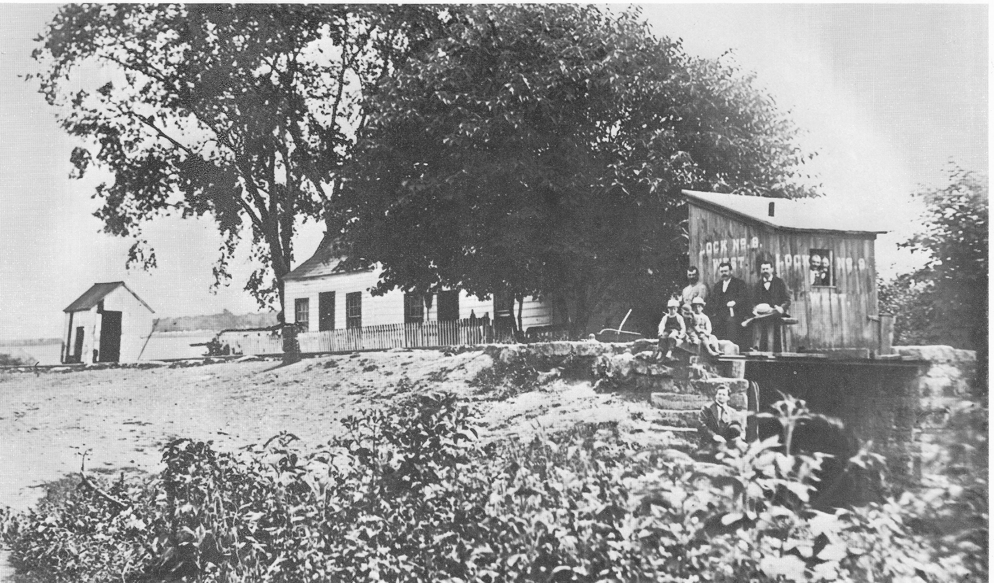
There is a county museum at Bread Lock Park, where a couple of my fellow board of recreation commissioners were volunteering, doing history tours and talks, and demonstrating with models how the system of locks worked, as well as a layout of the transportation systems, Easton-Morristown Turnpike, Morris Canal, Morris and Essex Railroad, Morris Canal, and Easton-Washington Traction Company (trolley) all in the same vicinity.

Between 1906 and 1924, all of those transportation routes were in use at the same time. The Easton-Morristown Turnpike of course dates back to colonial days and the highway is still busy. The Morris Canal was completed in the 1830s and abandoned in 1924. The Morris and Essex was completed to Phillipsburg in 1866, and is still active today. The trolley line began service in 1906 and was abandoned in 1925.
I didn't tell any of them I was coming, so I kind of surprised Dave Deitrich when we walked through the door with a posse and stroller. There were quite a few people in the place even besides our group, which was really great to see.


We went through the entire museum, and Ev was having a ball being out of the stroller and walking with either me or whoever else in the group. He gets lots of attention, so it's just great.

I noted a bar of Ivory Soap on one of the tables and asked the group if they knew the significance. None seemed to know, so I related the story of how the soap floated, and when it was discovered by a canal boat captain after dropping it while washing his hands, word spread that it was convenient for canalers and basically anyone in a maritie profession because the soap wouldn't be lost if dropped.
Proctor and Gamble, who owned Ivory Soap, reportedly sent a representative out to the canal store at the head of Inclined Plane 7 West to ask why they're selling so much of their soap, and the store keeper responded "because it floats". As such, Proctor and Gamble made that the slogan for Ivory Soap.


The place has a lot more stuff in it than when I was last in, and it looks great. There's also a display on Edison's concrete mile (which is the first of such in NJ, just west of where we stood), and a quote on the wall from him saying that solar power is the way of the future.

We exited the building and made our way along the former canal route to the west. The house that the museum occupies used to be a private home, built in the middle of the canal.
Bread Lock Park was the site of Lock #7 West, known as the Bread Lock because fresh bread was sold there. Lock houses often served as stores in addition to being a tender's residence. Only the foundation of the former house remains today, and the lock is filled in.
Next to the canal, a life size mockup of a canal boat is along the edge, with a roof built over it. It even has coal inside it, to show what it was like standing on the bow of a boat. This isn't just a surface mockup; the hatch opens and one can go down inside to see what living conditions were once like. Most people don't know that this can open, and so I don't post much about it in order to protect it. Eventually, someone will find out, post a video, and then it'll be a mess, but we're trying to preserve it for now.


Ev was not happy about getting back in his stroller, even though he'd had some time to run around, but it wasn't bad for too long. He'd gotten some exercise and was able to nap after a short bit.

The canal weaved out and way from Rt 57 a bit, and after a short obliterated section, it got to be pretty clear and good for a while. The trail continues to another blown out spot just to the east of the new solar farm. That farm was built over the former canal site where there was nothing left to save. It had been farmed out of existings to make for more crop lands. As a deal to allow the solar farm, the county got a trail around the outside of the property, and the county gets the former canal route when the solar field goes out of service.
We turned to the left on the trail, along the field edges to the south, then at the tree line parallel with the former Lackawanna/Morris and Essex Division (it was leased by the Lackawanna starting 1868), and continued west.


We passed by an old farm underpass, then continued over a wash and up along the edge of the solar farm to relatively new parking on Richline Road. The canal continues closer to 57 for a bit to the north, and then reaches the top of Inclined Plane #8 West at the start of Stewartsville.


When the trail reaches Richline Road, it jogs to the left over the railroad grade crossing, and then goes down steps to the right to continue parallel with the south side of the tracks. We continued along this, and then along the field edge as it swerved from the tracks to the south. The trail comes out at a driveway in Stewartsville off of Main Street, where until recently there used to be an old farm house and barns. The area, which was somewhat wooded before, is now pretty clear.

The canal from the crossing in Stewartsville is public land, and has been for decades. I color coded the maps for the state surveys made by my grandfather when I was a little boy, and I remember thinking how great it would be to hike it one day. Now, way over thirty years later, it is still not a trail, all because residents of the newer Stewart's Hunt development sued the county, and the county backed down.
There is now a pretty good greenway pretty much from the Delaware River to Bread Lock, but that piece is missing. I wasn't going to try to bushwhack through on that with the stroller, so we would take the way around. I do plan to push to get this cleared in the near future, and I'll personally volunteer to lead the volunteer party. One of the land owners back there said he would shoot anyone who walked through on that public land. I am very bitter about the fact that a death threat is just let go like that.

We turned left on Main Street, continued past the farms and such, then cut behind the church and into Rinehardt Park, which passes along a small tributary of the Merrill Creek and crosses it on a foot bridge. I'd gone through here in night hikes in the past.
I hadn't noticed previously that there is a very nice playground there, which is perfect size for Ev, so I figured I would have to bring him back there again very soon. There's another good one in Thomas Stewart Park up the road a bit, but I think this one is actually a bit better for him.


We crossed over the bridge, turned left at a field line, and then came out on Greenwich Street. There is a good paved trail parallel with the road here, and we were able to follow that uphill along the fields, which are within sight of the old canal in a tree line, so it wasn't all that terrible.

When we got to the height of the next hill, Dan texted me that he was getting bailed out, and soon his wife Tracy and Sam came driving by waving to pick him up back there.


We continued on the paved trail past the intersection with Valerie Place, and then turned to the right in the next field secton, and followed it diagonally out to Wyndham Farm Blvd. We turned to the north on that, followed it to the end, and then turned to the right on Thomas Carling Drive. This road dead ends at county park property where we could go around a gate and into the fields along the former route of the Morris Canal, of which only one tree line remains. This too had been plowed in for more field room in the years after abandonment.


Eric is good friends with Jim Lee III who lives as curator of the Jim and Mary Lee Museum at the top of Plane 9 West just ahead, and he texted him to see if he'd be around to say hello to the group while we were there.


We came out to the top of the plane, and I directed everyone to come to the very top, even though the clearer obvious route is to the right. That route misses a lot of the historic components up there, including some of the wire cables, the tar bucket for lubrication, and foundations. I also had to get some more then and now history compilations here. I'd already gotten one at Bread Lock Park for this one.


I got a shot at the top, and then another looking sort of down the plane where it was torn up for a garage. Just a little further down, I got another that didn't quite match up.
Jim Lee III came out to chat with us just a bit at his residence, which had been the home of his grandparents' years before.

After having a chat about the canal, we continued down the driveway along the plane, and I set up some more historic compilations. There wasn't a whole lot of daylight left, but I was glad to have gotten these finished. I wasn't going to have enough time to get all of the Phillipsburg ones that I wanted, but since it's so close, I could just come up with Ev and do it any time.
We got down to Rt 519, dashed across, and Eric helped me lift the stroller over the guard rail. The trail continues in the canal prism and then up to the towpath, but there's a lot of uneven terrain. Still, it was totally easy compared to what we had been doing at Merrill Creek, so I was happy about that.

When the old canal reached a former weir site where it and Lopatcong Creek had separated, there are steps to get down and up, and I got help to get Ev over it. It was very easy on the towpath beyond that point and becomes a crushed stone surface out across Strykers Road.
This area drives me crazy every time I go through it. The hideous warehouse on the right and across the creek valley destroyed a beautiful farmstead. I always thought this was one of the most beautiful roads in the county, and it gave way to this deplorable looking behemoth of a building.
We continued on the canal on the other side, which goes by a lovely giant Sycamore tree on its way to Rt 22.
There is no good way across Rt 22 yet, and really no good way up to the highway from the towpath either. A small herd path has been forming from years of us and others using the route up to the left, so we ended up doing that. Amazingly, I was able to pretty much get Ev and his stroller up this without much assistance.

Lerch and Cara decided they were going to cut out early, and so Jen decided she was going to take the early out too. The rest of us continued onward, and we got across 22 during breaks in the traffic to get over to the Taco Bell adjacent to the Phillipsburg Mall.
The mall is now long empty and closed, and there is a security guard riding around in the lot pretty regularly. For a while, there was nothing, and one could just walk in like the place was still open.
Ev and I sat down and had a couple of tacos, and I got a beefy burrito special because he seems to like those a lot.
Once we were done, it was starting to get pretty dark. We walked through the mall parking lot, and then descended to the former canal, which is now a retention pond in the development area, with trail along it.
I had wanted to do this next bit because there is a new section of the canal greenway open parallel with Lock Street, on the back of the townhouses, but it was getting dark to navigate it.
We ended up just walking the road because it was getting so dark. The one side of the road is nice and smooth, and the other side is crap pavement. It seems as though each municipality takes care of one side. Totally different.
Ahead, we approached the former site of Inclined Plane #10 West. I pointed out that this spot was unique in that there were two plane 10s. The original plane 10 is now a driveway, which the greenway uses to reach Lock Street. When the canal was first completed in the 1830s, it implemented overshot waterwheels, which was a slow process and they were at mercy of the levels of the Lopatcong Creek upstream for how much water power they'd have from the upper canal level.
The Scotch Turbines that came in the 1840s required less water power, and so the "new" inclined plane was built just to the west of the original one. The trail doesn't go directly down that, but rather on the road at that point past the tail race tunnel next to where the power house used to be. It was pretty dark as we were started to pass by that spot. There was still a little ambient light left.
Lock Street is not all that busy until the next intersection, and even then it's not too bad.
On the right, Lock Street Park is located where a school house, originally known as Green's School and later the Plane 10 School, used to stand, A bridge over the creek and former canal made of concrete replaced an earlier camelback bridge that was typical of canal crossings.
We continued along Lock Street a bit further, and then reached the former site of Lock #8 West. The lock is entirely buried, but the lock house remains as a private residence, although somewhat altered. We continued on Lock Street past that site, through the next intersection, and then along Lock Street to the former site of Lock 9. The lock house for this one is still standing as well, also altered.
When I hiked this through in 2003, I talked to a lady on the porch of one of the houses who told us that she remembered the canal boats floating by when she was a little girl. I wished I'd talked to her a bit more, because it's not often you chat with someone who actually witnessed the canal. She probably could have told me a lot.
We soon reached the intersection with South Main Street, crossed over the canal and creek, which were one again below Lock 9, and then just followed South Main under Green's Bridge ahead. Someone had painted "Help me Jesus" or something on the girder span of the former Lehigh Valley Railroad.
The stone arch viaduct of the former Central Railroad of New Jersey is the most priminent bridge, but both it and the Lehigh Valley lines cross immediately parallel with one another.
Lock 10 was at the point where the road crosses the creek today. I pointed out at this point where the towpath walkway still exists beneath the bridge, and there are even wear marks from over a century worth of tow ropes going against the piers.
Just ahead and after Canalside Pizza and Nortons liquor, a section of canal greenway trail closely parallels South Main Street. We followed this parallel with the creek, which was one with the canal again for a time. It split ahead and made its way at a higher elevation than the roads take. As we continued around a corner at the approach to the former Andover Ironworks, I pointed out where the only remaining aqueduct that carried the Morris Canal over a road still exists. Only the very top of the arch can be seen today, because the bridge has been almost entirely buried, but it is there.
There are usually homeless people sleeping in the bit of the arch they can get in, so we didn't get too close, but I wanted everyone to see it.
We continued on the greenway out to the road, and continued on Morris Canal Way just a bit until turning off onto the yards of the Andover Morris School. The canal passed through the front yard of that.
We came out to South Main Street, passed beneath the former Lehigh Valley Railroad overpass, and then turned to the left on Mercer Street, parallel with it to the south. We took the first left we were able, which brought us down McKeen Street, beneath the former Lehigh Valley Railroad bed, and out to Howard Street.
Directly across, a path went into woods, into what used to be the Kent Yard which brought the Lehigh Valley Railroad together with the Pennsylvania Railroad. It's a very pleasant way to walk without being on the road the entire time.
We headed straight into the woods, and then to the right on an abandoned railroad grade with mostly cinder surface. We continued along this for a while, until the Delaware River Park began to appear on our left. We then turned left, and left again parallel with the park behind a chain link fence. I was expecting to go around the fence for a while and come out onto paved trail further to the Delaware River side near the railroad tracks, but we came across a newly cut opening in the chain link that brought us back into the park early.
We simply go through to the grassy park and followed along the length of it to our cars and the end point.
It had been quite a great hike, but it went well over what I was planning to do. I think it ended up hitting over twenty miles.