Monday, August 26, 2013

Sunday Chester Area Hike!

NOTE: I work at for state parks, and if something comes up and I'm needed to work the date of this hike, I MIGHT have to reschedule, though it is unlikely. If anything changes I will update this promptly.

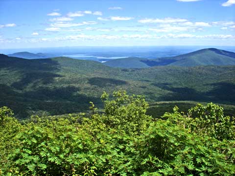
Join us for an awesome 16 mile hike in the Chester NJ area, mostly utilizing the Patriot's Path to connect Black River Recreation Area with Hacklebarney State Park. The route has one nice view, and mostly pleasant trails, scenic downtown Chester, abandoned railroad grades, abandoned telephone pole farm, the lovely Black River, abandoned former river swimming pools, iron mines, and more!
Hacklebarney State Park is located on State Park Road just south of Chester. From Rt 24/513, head south on Hacklebarny Road with the Black River to the left. Continue to turn right on State Park Road, and the entrance is on the left. Continue down the drive to the parking lot.
Some of the route we will be following is the FUTURE route of the Patriot's Path through the public park lands of Chester Township. It has not been marked yet, but the route has been chosen! These pastoral views are part of the new trail section through Chester. Currently, there is a short gap in the trail that this will fill! After passing through this area, hikers will have the opportunity to pick up more water and food or snack in scenic downtown Chester, also the route of Patriot's Path.From here, the trail makes it's way onto an abandoned railroad bed and descends to the Black River with more lovely scenery as we make our way parallel down stream and passing sites such as the old Cooper Grist Mill.The trail continues in part along former mine railroad routes, then as a foot path along the river, along what was once the estate of Elizabeth D. Kay. The tail becomes a narrower foot path and continues along the Black River. In addition to the main branch of the Patriot's Path, we'll take on the blue route, which is the Black River section, as well as the Conifer Pass Trail through lovely woods.We'll continue a bit further on Patriot's Path, then cut off along pleasant unpaved back roads to reach Hacklebarney State Park. We'll follow the old Orange Trail, no longer maintained, and visit some of the lesser known scenic spots within the park. There is only a short overgrown section, but not too bad here.
We then follow the formalized Hacklebarney Trails system back to the parking lot, following the riverside and the Main Trail.
This promises to be an extremely diverse and enjoyable hike with constantly changing scenery! If anyone has any questions or concerns, reach out to me here or at 908 343 8374. No public trans available to Chester.

Monday, August 19, 2013

Sunday, 8/25 Storm King, Black Rock Forest, and Helbing Farm Hike!

Join us for an amazing point to point hike between Storm King Mountain and the former home of my family, the Helbing Farm on the border of West Point and Black Rock Forest on Aug 25!Get a unique opportunity to learn the history of the land from my cousin who grew up there when Helbing Farm was a boarding house, and when visitors would come from NYC to bathe in the healing waters of Mineral Spring Falls which we'll also pass!
Mineral Springs Falls:
We will meet at 9 am at the Helbing Farm. Drive up Mineral Springs Road and the house is on the right side, down a bending driveway. The driveway bends to the right, then crosses a tiny bridge over Mineral Springs Brook. There is a wooden sign that reads "Helbing's Farm".

Once here, we will shuttle with as few cars as possible to Storm King State Park. We'll use many trails through this park and Black Rock Forest Consortium. This hike is not for weaker hikers as the terrain can be steep and rugged. We cannot take too long on the up hills because we are heading back to the Helbing Farm for a picnic dinner. We will be shooting for about fifteen miles as usual.
Along the way we will be stopping to swim in Sutherland's Pond, another historic swimming spot visitor's to the Helbing Farm boarding house used to frequent.
We may use as many as 15 different trails, for about fifteen miles, so everyone must try to remain reasonably caught up. The terrain is very rugged but the views are extraordinary. This hike is not for beginners.
Distance will be about standard 15 mile, but it's an epic area to explore.
Everyone signs a copy of my standard liability waiver before attendance. It can be found here: http://metrotrails.org/Metrotrails/Waiver.html
Bring plenty of drinking water, a lunch or snack, and weather appropriate clothing. This hike is rain or shine, and rain will only change the route somewhat.
Contact me for more info 908 343 8374

Monday, August 12, 2013

Upcoming: Corson's Inlet and Margate City Beach Hike!

Good stuff coming up as always!
This Sunday 8/18: Join us for a great point to point hike on the beaches between Margate City and Ocean City NJ! Meet 9 am at Corson's Inlet State Park boat launch on Bay Avenue south of town.

The parking area is on the left side for those traveling south, just before the bridge over Corson's Inlet. There is a boat ramp here, no fee charged.
On our journey south, hiking the perimeter of NJ, this section will lead us along the beach through Margate City and Long Port, then across two road bridges to connect them. We'll also stop for plenty of swimming (more than last time).
We will be using a grocery store parking lot for the beginning, and hike several blocks through parks and such to reach the boardwalk near the ocean. We'll walk a section of boardwalk until it ends, then get on the southbound beach. No pets allowed on this one; pets are not allowed on the beach between May and September. We'll hike through one dog beach section, but most of the way is not allowed.
Distance will be sixteen miles.
We'll head south through the towns of Long Port and Ocean City on the way. We will cross a couple of long bridges over inlets between towns which offer very scenic views of the surrounding area.
Everyone attending these hikes signs in on the standard waiver:
http://www.metrotrails.org/Metrotrails/Waiver.html
Feel free to contact me for more details: 908 343 8374
Furthermore, as planned on Sunday 8/25 we will be paying another visit to the Helbing Farm, most of which is now West Point! We will hike to the home of my cousin Dorothy, which is always a great time. The hike will end with a late day picnic! We will be hiking between Storm King Mountain and the Helbing Farm along the trails parallel with the Highlands Trail, and stop to swim at Sutherland Pond! More to come on that later.
I haven't decided on the hike yet for Labor Day weekend (Sunday). 

Monday, August 5, 2013

This Sunday: Southern Catskills!

Join us for a tough day hike in the southern Catskills including the high peaks of Table and Peekamoose Mountains on the Long Path! Read on for more details...

We will be meeting at 9 am at the Peekamoose Lower Field parking area located on Peekamoose Road in the southern Catskills. To get there, it will depend on where you come from, but no matter what you must get on Rt 209 north of Port Jervis NY. Take the turn north for Rt 42 toward Monticello. Continue on 42 north, right on 55, left on 55A, then continue on Sundown Road. Beyond Sundown, continue through on Peekamoose Road. Please consult a map to get to this area. It's a very back woods area with small roads where it's easy to get confused. I may have no cell phone service, so allow for enough time to figure it all out!
After meeting, we will shuttle a short distance to our beginning point. We start with an out and back hike to the Red Hill Fire Tower. Once down from there, we walk a short road walk to the Finger Lakes Trail, which follows part of Denning Road. That road becomes dirt, and is part of the trail route. It's very nice and allows for swim spots in the East Branch of the Neversink River.
We continue on Finger Lakes Trail to it's eastern terminus at the Long Path. From there, we begin to follow the Long Path south over Table Mountain and Peekamoose Mountain, some of the Catskill 3500s. Be prepared for long and steep climbs at times, though these are not as difficult as the ones further to the north.
After the last descent to Peekamoose Road, we'll follow the road a bit and check out some nearby waterfalls, maybe take a dip if it looks tempting enough!

Note also I may be doing a Friday night hike! Stay tuned to our Meetup group for more!