Thursday, November 27, 2014

Metrotrails Nov-Dec 2014

Hello everyone!
This fall has been going great with the Metrotrails events! There have been plenty of interesting trips that have forged important connections and opened us up to new areas.

October was a landmark month for us in that we have seen the greatest gain in membership in many years! Thanks to a lot of cross posting through other interest groups, most of our posts through our facebook page are doing 95% better than those of the past, and our meetup group saw the largest membership influx since implementing it's use in 2011! Great news! Check out the stats!
November 2014 Stats for membership.

Because there are so many newcomers to our group, I'll take a few moments to explain what we're all about...
Metrotrails was formed informally in 1997, and the mission is to assist with planning, development, maintenance, and promotion of trails and public open spaces. Have a look at our schedule of events. If you're familiar with other hiking groups, you might notice a huge difference in the locations of posted events. We almost never repeat the same hike, and we host the hikes in places most of the larger hiking groups don't visit, and try to cover longer distance.

We engage in long hikes as a primary function, but also plan and develop new trails mainly in the Skylands region of NJ. Ours is an eclectic group of people of all ages and all walks of life, from all over the tri state area.
You might notice that the location of the group changes from time to time. This is because the Metrotrails operating area is throughout the New York/Philadelphia metropolitan area, hence the name "Metrotrails", and our logo representing two cityscapes with the path and tree between.
Expect to see events posted all over New Jersey, as well as New York, Pennsylvania, and even some Delaware and Maryland from time to time. We may soon include a couple of hikes in Connecticut as well.
Each hike is intended to be an entirely different kind of experience than the previously posted ones. We'll cover mountains and formal trails, as well as rail trails and canals. In the Summer time there are beach hikes, and in the Winter urban city hikes.
If you see a hike posted but opt not to do it, don't assume the same  hike will be hosted around the same time next year! After almost 18 years, we've barely repeated any!
Also, I endeavor to connect each hike physically with other hikes I have organized. These hikes total more than 13,000 contiguous miles, more than half way around the globe if stretched out. As of now, our furthest west point we've reached is beyond the Susqhehanna River into Cumberland Valley, the furthest south has been Cape May (although I've connected now to Baltimore, which isn't as far south), furthest north is Yankee Hill on the Mohawk River of NY, and furthest east surprisingly is Albany.
I also try to showcase the historic and ecological aspects of the areas we hike.

We have quite a few interesting events coming up! Here's what to expect!
Trail work:
We recently completed clearing and blazing the new Musconetcong River Trail from the River Resource Center in Asbury to Valley Road naring Hampton! The new trail was developed partially by this wonderful non profit, but they needed some help! Some of what they cleared was long grown in, and other sections were never marked at all.  In about a month and a half of work trips, we were able to clear and blaze this route which is now open to hikers and fishermen. It has some nice deep, secluded fishing holes and lovely river views the entire way. Trail heads are along the river on Maple in Asbury, and on Valley Rd outside Hampton, Warren Co. side of the bridge. There is a stream crossing with no bridge yet at the Valley Road so, so requires a good hop. The through trail route is 1.7 miles. We will be working to redevelop an orange loop trail as well in the near future. (Hikes meet at 8:30 am unless otherwise noted).

11/30: Mahlon Dickerson
Join Dan Lurie, subbing for me this weekend on a hike in Mahlon Dickerson Reservation and Sparta Mountain. The exploratory loop includes foot paths as well as the historic Ogden Mine Railroad right of way. We offer a guide to this trail on our official website here:
http://metrotrails.org/Metrotrails/Ogden_Mine_Railroad.html
12/5: Friday Saddle River Hike
Join Dan Lurie and company for a jaunt along NJ's Saddle River! Should be a very interesting route!

12/6: North Hunterdon/South Warren Hike and Decemberween!
One of our traditions is hiking 'close to home', visiting my grandfather and hiking local trails. There are still so many we haven't covered, and this time we'll do Point Mountain as well as the new Port Murray Preserve, including the new Morris Canal Trail we are working to develop. The hike ends at our Decemberween Party at Washington Theater!
12/6: Metrotrails' Decemberween Party (6:30 pm ish). Cost: $10.
Join us for a costume party in December, in the historic Washington Theater with music by our friend Jack Lowry's band, GYPSY FUNK SQUAD! This is a fund raiser to help SAVE THE WASHINGTON THEATER! The owners recently acquired permits to demolish this landmark, and help is needed to save it from these untimely demise. There will be popcorn concession. BYOB.
12/12 Tentatively Planned nigth hike, 3:45 pm.
Hike parks and old rail lines in northern Hunterdon County
12/14 Appalachian and Darlington Trails
This point to point hike follows these two famous trails in the mountains just west of Duncannon PA, and is a major connection to 100 more miles we've explored in Cumberland Valley. Great views and lovely terrain.
12/21 Annual Holiday NY City Hike! 9:45 am
Always among our best attended events, this year we will hike the High Line again, with it's newly opened final section, then head to the East River and follow the waterfront north with outstanding bridges and much more. Meeting at xmas tree in Penn Station.
12/29 Jersey Perimeter Series: Port Norris and Turkey Point. Jersey Perimeter completed so far
We grow closer to completing the entire perimeter of NJ with every trip! This section takes us along Maurice River and north through former oyster capitol of the world.
These hikes have been much more interesting than one might think!
1/1: First Day Hike on Warren Highlands Trail!
Another of our great projects is a future cross county trail in Warren County, and we'll hike what we have complete so far on New Years Day! Should be a lovely hike with good views, abandoned mine, and more!
As we move on through January there are even more great hikes coming up that include lesser known rail trails, both urban and rural trips, and more!

Hope you can join us for many of them!

M'ke Helbing
President
Metrotrails

Saturday, November 8, 2014

Metrotrails: Nov 2014

Hello all!
So far, the fall has been off to a great start, and we have plenty more to go!
This past weekend, we had two great hikes, one around the perimeter of Spruce Run, and another in south Jersey for our perimeter series! Both were excellent! But what do we have coming up??
Planning
11/2: Appalachian Trail; Bear Mountain and Fahnestock
This hike will be mostly a linear route on the AT between these two parks! It should be a nice scenic way to have our annual costume hike, which has become a Hudson Valley tradition!
11/4: Jersey Perimeter, Forked River and Waretown
For Election Day, one of the only remaining sections on the entire eastern portion of the state, this back roads and trails trip will have a little off trail, some lovely back roads, estuary views, and some unconnected trails. Meet 10 am in Waretown, see description.
11/5: Musconetcong Trail Work
Meet at 3:45 pm to help with the finishing touches on a new trail connecting the River Resource Center in Asbury with Valley Road! This lovely trail will help both hikers and fishermen, and of course the programs of the wonderful Musconetcong River Watershed Association!
11/8: Metrotrails Thrift Excursion and Mini Hike!
Join us for some short local walking around, and visit one of my favorite thrift stores to purchase silly cheap suits for under $10 that many of us in the group have come to be known for!
11/9: Lackawanna Valley and Moosic Mountain Loop
In the Carbondale area, this hike will be the next in a series to cover the Lackawanna Heritage Trail, for which we've had a few, and another section fo Moosic Mountain. The coal heritage of the area makes this quite interesting!
11/11: Appalachian Trail Cross Susquehanna!
Join us to cover yet another section of the AT, this time between the Ebberson Preserve and Duncannon across the Susquehanna River! Nice views should be had throughout the trip as leaves will have fallen on ridge line!
11/16: Bluestone Wild Forest and Kingston
This hike is the last connection I've needed to tie 150 miles of our Catskills hikes to everything else we've done! We'll cover all of the trails in Bluestone Wild Forest, the easternmost and probably overall easiest trail system in the Catskills preserves, and then follow the old rail line from where we left off between West Hurley and Kingston! Should be very interesting!
11/23: Jersey Perimter Series; Thompson Beach to Port Norris
This leg of our ongoing NJ perimeter journey will be to circumvent the long estuarine wetland where the Maurice River connects with the Delaware. We'll be walking estuary trails, sand roads, back roads, abandoned rail line, and more! This should be quite an interesting one!

ALSO: Mark your calendars for Saturday, December 6th....rather than the regular Decemberween party that is usually hosted by Carol and Rob (they're doing a regular Halloween Party this year), we will be hosting a Decemberween fundraiser party at Washington Theater!
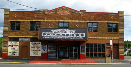
The theater is in grave danger of being demolished in early 2015, unless our friend Marco Matteo can come up with enough money to purchase it. Many fund raisers are going on, and we want to help him out! There will be a regular hike that Saturday ending at the theater, and then we will have the party, with our friend Jack Lowry and his band Gypsy Funk Squad entertaining! Cover is $10 which will go toward helping preserve the theater!

I would also like to thank our friends Michael Gronsky Jr. and William Honachefsky Jr. of Union Forge Heritage Association for giving us the tour of their new Solitude  Heritage Museum at the historic Joseph Turner House on a recent hike. After being removed from the Solitude House in High Bridge, they opened a lovely new museum in the Turner House, with it's original section dating back to 1760.
Continued renovations will restore the home to how it would have looked circa 1830.
They're doing a fantastic job, so when you're not hiking on a Sunday, stop by the place on Van Syckles Road, Union Township and have a look at their displays!

Development...
We have been working hard on our projects...Warren Highlands Trail has been at a stand still due to land owner issues with the latest piece I have to cut through. With things sort of stalled, we've taken on a secondary project helping Musconetcong Watershed Association rehabilitate existing trail and build a stretch of new!
Before...

After!
The trail stretches between the River Resource Center off of Maple Ave in Asbury NJ and will connect to Valley Road/Shurts Road closer to Hampton. The trail is currently about 2/3 clear, and we will be hopefully finishing initial clearing next Wednesday evening at 3:45! The trunk trail will be blue blazed with a short loop near Asbury will be orange.
Once this project is finished, we will be moving to Port Murray to develop the new Morris Canal Trail. This will open a good, long section between Hoffman Road in Port Murray and Harts Lane to the west. A foot path we will clear will circumvent a piece of private land on the canal.

Maintenance
Continued maintenance will be needed on Warren Highlands Trail. I may be posting clearing trips on that in the near future.

Promotion
The featured trail for this newsletter will be Paulins Kill Valley Trail!
Always one of my favorite trails, it stretches for nearly thirty miles from Columbia NJ to Sparta Junction. It's diversity of terrain, proximity to water, and intimacy with it's environment make it probably the best rail trail in the state of NJ.
It passes by amazing historic structures and ecological wonders.
On our official website, we offer a mile by mile guide to the Paulins Kill Valley Trail that can be viewed on PC or smart phone with great simplicity, following this link:
http://www.metrotrail...­
The trail begins officially as part of the Liberty-Water Gap Trail at the Portland-Columbia Footbridge.
The side of the old Rt 46 along the river is striped as a pedestrian and bike lane. It follows the road for a short time, then descends down a crushed stone path to the edge of the Paulins Kill River. This section is of course not former railroad.
After passing beneath Rt 46, the trail ascends to the left, then crosses the Paulins Kill on 46. On the other side, it turns a hard left along the edge of a private yard, along the right of way of the 1876 Blairstown Railroad, the first part of the New York, Susquehanna, and Western Railroad to be developed (Blairstown Railroad was absorbed into the NYS&W system and extended in 1881).
The trail turns away from the rail bed again past a former quarried area, then returns to it within Columbia Lake Wildlife Management Area where it passes by the dam for Columbia Lake.

The right of way is now a gravel road, which soon leads beneath Interstate 80 by way of a giant metal pipe. Prior to the construction of Rt 80, there was a junction here. The southbound NYS&W followed the earlier Blairstown Railroad alignment to connect with the Lackawanna old main line in Delaware, while a northbound main line crossed the Paulins Kill where the highway crosses today, and traveled north through Delaware Water Gap and on to Stroudsburg.
Columbia Lake is a silted in mess, more like a swamp these days, and the trail remains a gravel road out of Columbia Lake WMA. Beyond, the rail bed becomes somewhat overgrown and difficult to pass through at times. Because this section is so rough, Liberty-Water Gap Trail has routed it's marking to the right, then left onto Bruglar Road.
From Bruglar Road, the trail is shown on all state maps as going through, but there are often "no trespassing" signs on this side. Walking from Hainesburg, at Station Road, there are state park signs, but from this side they are missing for the first part. The rail bed can be quite washed out and wet in this section toward Hainesburg.
The trail continues east from here, through lovely woods and pastoral settings.
Although this is a rail trail, it is not a wide monstrosity like so many others can be. At times, it is just a narrow path that bares little resemblence to the rail line it once was.

Along the way, the trail passes through the village of Kalarama, where today we find the Blairstown Airport. The trail leaves the railroad right of way altogether here, and skirts the south side of the airport. At one point, the trail is right along the side of one of the runways!


Whistle signs and mile markers reading "JC" for Jersey City can be found along the way, as well as many other historic remnants.
When the trail reaches Blairstown, it passes through Footbridge Park. This lovely park is great for a side trip over it's namesake foot bridge. Trail users can cross the bridge, and immediately on the other side is Dale's Market, where snacks and drinks can be purchased. They have OUTSTANDING baked goods in the back!
Northeast of Blairstown, the trail crosses over the Paulins Kill on a slack water section above the village of Paulina. The Paulina Dam is probably the loveliest dam in the county, and the trail along the lake is beautiful.

The trail crosses the river again ahead, and then reaches the settlement of Marksboro. It is  here that the Ridge and Valley Trail breaks away. When complete, this trail will connect Paulins Kill Valley Trail to the Appalachian Trail. Most of it's infrastructure is already in place. The first part of it mostly follows the old White Lake spur, which broke away from the NYS&W to reach the Marl Works, a limestone processing plant for material dredged off of White Lake. The material was hauled by train to Newark where it was used to neutralize it's sewer system.

Shortly after leaving Marksboro, the trail crosses the most beautiful bridge in it's entire length (save for the Paulins Kill Viaduct which it does not cross). It is a through style truss bridge again over the Paulins Kill.

The trail becomes wider in the sections north of Blairstown. It remains a good width until reaching a farm area in Fredon Township vicinity where there have been washouts. It then resumes as a narrow foot path, and alternates depending on the accessibility of the sites.

To the north of Marksboro, there is even a wheel truck left over from an old derailment that has never been removed!

There are sometimes bridges missing along the line, such as this one at the downstream end of Paulins Kill Lake. The trail routes it's way down to the road for these sections, then returns on the other side.
The trail makes it's way to Swartswood Station area, where the platform still stands. Here, a section of rail  has been replaced as sort of a demonstration of what the line would have looked like.

Ruins of old water towers and other structures also exist in this area. The trail descends and ascends again to cross Newton Swartswood Road, where another bridge is missing. Beyond, there was a junction with the Lehigh and New England Railroad, which had about wenty miles of trackage rights on the NYS&W from Hainesburg.
After this junction site, the rail line left the Paulins Kill Valley on it's way to Sparta. The trail now passes through dramatic rock cuts on it's way heading east.

Beyond this point, the trail passes through more woods and farms and regains it's pastoral/rural character like in the westernmost portions.

It again looks more like a footpath than a rail trail.

At Warbasse Junction, the NYS&W crossed the Sussex Branch of the Lackawanna, and today the Sussex Branch Trail crosses the PKV Trail. Both trails are very very similar in character. One of the best rail trail hikes in the state is the Sussex Rail Triangle using the Lehigh and New England from Swartswood Junction, PKV, and Sussex Branch from Ross Corner.
In the vicinity of Warbasse Junction, the largest mushrooms we've ever witnessed on any Metrotrails event grow directly on the edge of the trail. The amazing size of these is unlike any we've seen anywhere, and it's owed to the narrowness of the trail and certainly it's proximity to moist ground.
The trail crosses the abandoned Lackawanna Franklin Branch ahead, which is not yet a trail. It then crosses a somewhat decked bridge, but nothing like the others on the line. The trail continues, though less developed.
A second bridge is out nearing the eastern terminus of the trail, with a sign facing it from one way. The bridge is just a narrow I-beam and can be crossed with ease. It is not as easy to access with a bicycle however.

The trail abruptly terminates at the rail yard where it once crossed the Lehigh and Hudson River Railroad. Ahead, the NYS&W still has tracks in place all the way to Jersey City. There is no offficial access from the eastern terminus of the trail, although the seclusion of this section is nice for an out and back hike.
From the western end of the trail, the NYS&W continued north through the water gap, and crossed the Delaware at Karamac, where there was once an inn.

From the Rt 80 bridge over the Delaware north to the former trestle site, the rail line can be walked, as it is now part of Karamac Trail. It is a beautiful unmarked section along the river worth exploring. Also, on the opposite side of Columbia Lake from Paulins Kill Valley Trail, a similar gravel road follows the rail bed for a short time.
In Pennsylvania, the right of way is not yet a trail in Minisink Hills, but it is informally used as such.

The old line once crossed the Broadhead Creek on a high trestle, over the Lackawanna line, then headed to Stroudsburg. Originally, the line made a connection with the Lackawanna at "Gravel Place" to get coal, but in 1893 NYS&W opened the Wilkes Barre and Eastern, a wholly owned subsidiary so it'd have it's own line. It was short lived, being abandoned in 1938.
On the other side of Brodhead Creek, the NYS&W is again a trail within Glen Park where there is parking. Washouts force the trail deviate somewhat from the original route, but it's an outstanding route to hike.

In closing, hope everyone can join us on more hikes soon! We have some fantastic stuff coming up!
Best Regards

M'ke
908 343 8374 cell

Friday, October 17, 2014

Metrotrails: Autumn 2014

Hello all,
We have lots more great stuff coming up through the month of October!
Moving forward, we will cover plenty more local spots, develop new trails, and also branch out into areas farther away.

We recently made a very huge connection in the Catskills covering the new re route of the Long Path over Romer Mountain, Mount Pleasant, and Cross Mountain. We covered this in addition to the entire Burroughs Range as a day hike. Quite the undertaking!
We have plenty more interesting things coming up, and so many of them are part of a "series".
For those of your who are new to Metrotrails, let me explain a bit of what we do with our hikes (Of course, we build and maintain trails too, but it all started with the hikes).
Every hike is intended to connect to a previous hike we have done. These hikes all become part of an interconnected series. Just as many hikers traditionally will try to hike the entire Appalachian Trail, we are similar but on a much broader scope.
The Jersey Perimeter Series is a perfect example.
No one has ever hiked the entire perimeter of NJ as closely as possible, and that was not something that started as a firm "plan". Back in the early 2000s, it was a goal to hike all the way to the open ocean. This was reached through a rail line series; I had wanted to hike the entire Lehigh Valley Railroad route from Pennsylvania to it's former eastern terminus at Perth Amboy. We did this, then opted to continue hiking the beach to the south. Similarly, we followed the coast as closely as possible to the north. On the western part of the state, we hiked the old Bel Del Railroad right of way and Delaware and Raritan Canal. By the time I reached Seaside Heights, I knew I wanted to one day hike the entire perimeter of the state. It did not become a serious endeavor, where we would devote one Sunday per month to the effort until a couple years ago.
Our last piece of oceanfront beach was part of LBI, which we recently finished up.
We were also featured in a very nice article in the local periodicle, the SandPaper out of LBI for this accomplishment! You can see the article here, it can be found on page 38:
http://thesandpaper.v...­
Further, we had the good fortune of even more PR through the Rails to Trails Conservancy who have spotlighted NJ in the most recent publication! The article of theirs can be seen here:
http://community.rail...­

So what is coming up and where does it fit? For this newsletter, I will go into a bit more detail about where we are going and why. It will shine some light on what might crop up as more future series'....

10/19: Governor Dick Hill and Mt. Gretna Area Loop
This hike will be a loop meeting in the village of Colebrook, Lebanon Valley Rail Trail lot. The hike will be mainly on the rail trail and the Horse-Shoe Trail.
The Horse-Shoe Trail is a very interesting trail that was intended to connect Philadelphia with the Appalachian Trail in St. Anthony's Wilderness, and I have been trying to complete the entire thing. Four more hikes will finish the trail for me.
10/25: Spruce Run Perimeter

This Saturday hike will be hosted by both Metrotrails and the NJ State Park Service through my job. It was decided that we should do the entire perimeter of the reservoir because the water is currently the lowest it has been in at least 12 years. As part of the hike, we will visit the new Solitude Heritage Museum at the historic Joseph Turner House. We celebrated our 500th hike years ago with the opening of their Taylor Steelworkers Historic Greenway which we helped to develop, and we've been wanting to bring the group to their newest museum, so this was the perfect opportunity.

10/26: Jersey Perimeter; Jakes Landing and East Point
We return to the Delaware Bay area where we left off last fall to continue north from Jake's Landing. The route will be back roads, woods roads, trails, and more. It is one of only twenty some hikes needed to complete our perimeter journey. This will also be one of our annual costume hikes. These routes are usually rather easy but are a completely different experience than some of the traditional trail hikes.

10/31: Gregg's Halloween Hike and Party
Long time Metrotrails member Gregg Hudis is hosting people at his house, and we'll do an area hike as part of it.
11/2: Fahnstock and Hudson Appalachian Trail
The Appalachian Trail has always been something we at Metrotrails avoid doing in full sections, because everyone seems to do that, but some sections are not always as easy to do as a circuit because of the lack of loop trails. With only a few in this section, it was decided we'd do some all-AT hikes with the purpose of connecting to the Connecticut line! We'll be doing a few AT hikes both north and southbound.
11/4: Jersey Perimeter; Forked River and Waretown
This Tuesday hike, beginning at 10 am for Election Day, is another in the perimeter series that we missed along the Barnegat Bay. The entire east side of the state is nearly finished, save for a couple of stray sections. This is the biggest chunk left of the few. We'll follow back streets, random woods, and some lesser known trails through the area in what is sure to be a pleasant walk.
11/9: Lackawanna and Moosic Mountain Loop
This hike is part of the Lackawanna Heritage Trail series, but works out as a loop to further explore Moosic Mountain, a very interesting area steeped in coal history. This is also one of four planned hikes to connect to Hancock, NY where the east and west branches of the Delaware come together. We have one unconnected hike up there. All connecting hikes should be very interesting routes along the O&W Rail Trail and the D&H Rail Trail, both of which we'll explore more in the future.
11/11: Veterans Day Appalachian Trail Cross Susquehanna Hike
Another AT hike, this one too has very few loop opportunities, and therefore is posted as a linear trip. It will lead from where we last left off on the AT at Ebberson Conservation Area and head west across the Susquehanna to Duncannon. It is one of two hikes necessary to connect with another hundred miles I've done at Cumberland Ridge and Valley. This one will have great views of the Susquehanna.
11/15 or 11/16: NY/NJ Ramapo Hike
This hike is not yet posted, but it will likely be a very diverse route between NY and NJ following several trails in the Ramapos. There are so many we've yet to cover, and the area is simply wonderful to hike this time of year. We will likely cover some of the Ramapo-Dunderberg Trail and many others with great views and historic sites in Mahwah.
11/23: Jersey Perimeter; Thompson Beach and Port Norris
This point to point trip is the next one up from East Point, but it will overlap the previous one just slightly. The hike is almost entirely different but reaches a different point on the bay. It will otherwise be very similar to the previous one, but unpredictable as these hikes tend to be. This one too features some lovely dirt roads.
11/30: Bluestone Wild Forest to Kingston
This is interesting hike is part of the series to hike the entire Ulster and Delaware Railroad, as well as the final connection to all of the trips we've done in the Catskills, which encompasses 150 miles of stuff that has not been connected to the rest of our hikes. We have been working on connecting this for quite some time.
After this, we will have covered the entire Ulster and Delaware right of way from it's eastern terminus at Kingston Point to Mt. Tremper, then from Fox Hollow to Bloomville. The short section in the Phoenicia area and the remainder of the line to it's former terminus in Oneanta NY may one day be the subject of other hikes, though probably not for a while because of the long distance.
Also, note that this year's holiday NY City hike will be 12/21!

Now, with a greater understanding of these series', I would like to offer something a little more with these news letters, in the form of more rich trail guides and history.
Many of the routes we have followed are formal trails, many are not. In some cases, portions are now trail but other sections are not. We present some of these sections on our official website, www.metrotrails.org as sort of "conceptual trails".
This time, I'd like to showcase the Bel Del Rail Trail...you can see our guide to it here:
http://www.metrotrail...­
The trail has fit in a great deal with the perimeter of NJ series.

In Trenton, the trail is separate from the Delaware and Raritan Canal. The two come together on the north side of town. It is a shame that the rail trail loses it's identity to the more famous and popular D&R Canal. Of course, the canal came first, but the trail on the Delaware River side more closely follows the railroad bed than the canal.
The trail merges with the D&R Canal along the feeder north of town, from which point the trail crosses the canal on a former rail bridge and remains on the rail bed most of the way. Most trail uses do not even know that this section was the railroad as well as canal towpath.
There are only occasional clues that this was part of the old Belvidere and Delaware Railroad.
"The Bel Del" was completed to Lambertville in 1851, then extended to Belvidere by 1855 via Phillipsburg. It was later extended in 1864 to reach the Delaware, Lackawanna, and Western at Manunka Chunk.

Only the occasional spur bridge to quarries across the feeder canal show the former history as a railroad line.
The section of trail heading into Lambertville is quite scenic with many views to the Delaware River.

In Lambertville, the trail route changes. Tracks appear once again along the old Bel Del, and the state park's trail crosses to the other side of the canal. In more recent years, excursion trails ran to Lambertville from as far as Flemington, but have not been used in many years.
The tracks are mostly overgrown, and they diverge from the canal for a time.
The tracks have a path along them which is used as a loop within the town of Lambertville, although the section with trackage is not signed with any trail signage. This section also has an abandoned car on it.
To the north of here, the rail line crosses over the Alexauken Creek on a bridge, while the adjacent canal crosses by way of an aqueduct. Just beyond this point, the towpath trail once again crosses and follows the railroad bed to the north.
The spur line, originally the Flemington Branch of the Bel Del, breaks off to the right, crossing the canal. Maps will show this as the Pennsylvania Railroad, which absorbed the entire Bel Del system later.

Another quarry spur is the lone remnant of the rail line in the section ahead. The canal weaves around, while the trail remains on the level, flat path of the railroad line. After not long, the canal departs to the left, with it's own trail along the side, though less developed. From here to Frenchtown, the trail almost solely follows the rail bed.
At Stockton, the trail passes the old station, with the canal further to the west, closer to the river. The canal trail ends, while the rail trail continues to the north, to Prallsville. A little section of track and an historic marker thankfully offers a glimpse of the railroad's history. The rail trail crosses the Wickecheoke Creek at Prallsville Mill, pictured, and below the D&R Feeder Canal nearly disappears into the river. A narrow berm of trees in the river is all that remains of the towpath, and the current flows through the former canal.
The trail passes below Devil's Tea Table to the north, sadly off limits to public these days for one reason or another. The view from this vista is absolutely outstanding, just above the rail trail.

The rail trail continues past Bull's Island. This was the northern terminus of the D&R Feeder Canal. Although there was no canal north of this spot, I have gotten into many arguments with people claiming their was. This is of course due to inadequate education on the railroad.
The rail trail continues to the north, to Frenchtown. 12th Street is the northernmost access to this trail. The trail continues a bit further to the north, but then abruptly dead ends at the edge of a farmer's field with no access. An informal path follows the right of way until overgrown tracks start up, and it enters the former Milford Paper Mill area.
The tracks beyond remain overgrown in many places, but quite beautiful. It is hoped the trail will be extended to Rieglesville.
The route makes it's way through the narrows below the Milford Bluffs, all preserved land with trail access from the east, and is adjacent to the walkable River Road. From the road and railroad are some beautiful seasonal waterfalls.

North of this point, the railroad diverges from the road and will one day make an excellent trail, but for now remains overgrown. It passes by some historic passenger cars along the way, which are difficult to access.
At Rieglesville, the Highlands Trail crosses the Delaware River. A connection here would be a valuable connection to the regional trail system.
To the north of Rieglesville, the line passes through Carpentersville in Warren County, with one of the most impressive collections of kilns in the state.
The line north of Carpentersville remains clear and in good repair. It is used by excursion trains out of Phillipsburg, which are well attended. The former Carpentersville Station site is a lovely tunnel of foliage.
Many ruins throughout this area between the railroad and the river are very interesting and merit further investigation. A trail along the rail line would be fantastic, but difficult in the narrower areas.
In Phillipsburg, the line crosses the former Morris Canal Inclined Plane #11 West, and beneath the former Lehigh Valley RR and Central RR of NJ.
Several historic sites are a short distance from the line in Phillipsburg including the Union Station, Interlocking Tower, Pump House, and more. The Warrren Highlands Trail, which we developed, is also there.
The line continued north through Warren County with connecting branches from Brainards to Martins Creek, as well as the Roxburg Branch to the PP&L Plant across from Belvidere.
In Belvidere, the line dead ends where it is currently used as a spur to Hoffman-LaRoche vitamin facility. It is inaccessible.

North of Hoffman LaRoche, the line is used informally as a trail to access the old Lackawanna Main Line, the Warren Railroad, at the north side of Manunka Chunk Tunnel. It remains somewhat clear from where it once crossed over Rt 46. Some of the old highway route can be seen deviating from it's current path at this point, where the smaller culvert once stood.

The old Warren Railroad at Manunka Chunk Tunnel is state park land, administered by Jenny Jump State Park. This old rail line is now an  unofficial trail, on public land all the way to Rt 519 in Bridgeville.

The Bel Del has been one of the most important pieces of the NJ Perimeter series for the western part of the state. Hopefully one day a trail will be developed on the right of way further. It would be amazing to be able to hike or bike all the way from the Delaware Water Gap to Trenton. It's not too far fetched.
For any further info on upcoming hikes e mail me at sneezehorse@hotmail.com or call or text 908 343 8374

Hope to see you all on the trail sooN!
M'ke
Powered by mvnForum