

Hike #1544; 4/23/23 Safe Harbor and Turkey Hill Loop with Brittany Weider, Diane Reider, James Kohan, David Adams, Professor John DiFiore, Kirk Rohn, and Everen
This next hike I planned as a point to point trip, focusing loosely on tracing the old Pennsylvania Railroad route between Columbia and Safe Harbor. I wanted to follow the trails of Turkey Hill, and then descend to trace back roads and such to the north.

I've already walked from Turkey Hill area north on the roads, but I did it in the dark, and a lot of it on the tracks. There is still a good amount of stuff to see, and it is a good cool weather hike. I really was pushing hard to get more cool weather hikes out of the way later than I should have been.
I also was definitely a little too ambitious when planning this one, because the mileage was coming out to be much longer than what I was planning after heading a ways into it.
Still, everything works out in the end, and we ended up having really a fantastic hike, which set us up for more of them in the future there.
The main themes of this were Turkey Hill, and the Atlgen and Susquehanna Branch of the Pennsylvania Railroad, known as the Enola Low Grade Line. When we hiked to Columbia, I planned to hike all of the prominent trails out of the area, and there are a lot of routes to trace from there.

I figured we would slap the Pennsylvania Railroad on there this time, and just get it out of the way, and do the Turkey Hill trail system before all of the leaves came out because we'd get better views.

It really wasn't the right time to start on either of those I came to find out, but the hike ended up going absolutely great and I'm glad we did it as we did.
We met in the morning in Columbia, near the terminus of the North Lancaster County River Trail that we'd hiked previously. There is some side road parking near the railroad tracks there, which we'd used in the past.
From there, we shuttled to the south, to the Safe Harbor Park where Conestoga River spills into the Susquehanna.

The spot I chose to park, right along the Conestoga River in the park, was steeped in history as well.

The park didn't have gravel or pavement where we stopped. It was just a sort of pull off in the grass along the creek sort of deal.
This location was the former site of the towpath on the Conestoga Navigation, a canal system I have great interest in tracing as well.
This one is referred to more as a "Navigation" because it was mostly the canalized Conestoga River. Dams with adjacent locks were placed, with a towpath along the river for navigation 18 miles from the Susquehanna River to Lancaster.

There would have been a rock fill crib dam on the Susquehanna at the time to provide slack water enough to ferry boats across to the Susquehanna and Tidewater Canal on the other side, which would have had an outlet lock (probably destroyed, but I'd love to have a look).

The Conestoga Navigation was active from 1829 to 1857. Boats climbed a total of 64 feet utilizing nine locks, each 100 feet long by 22 feet wide.

Lock 9 I understand was destroyed when the nearby Safe Harbor Dam was constructed.
We parked and began our walk through the pleasant grass upstream along the Conestoga River. It wasn't long before we reached the River Road Bridge, which is built on the abutments of an earlier bridge. The bridge is a nice one, with a good walkway across.
As we reached the other side of the bridge, I was astounded that the Conestoga Navigation Lock 8 was in great shape, collapsing somewhat, but with recognizable gate pockets.

The entire lock area was fenced in with chain link for its own protection as well as the safety of others.

This lock lifted boats six feet. Just downstream from the bridge, a little island existed, which might have been some sort of delineation for the old canal.
We continued across the bridge, and passed a sign denoting this as the former Conestoga native American village along the creek.
Once across the bridge, we made a hard left turn onto Warehouse Road, which goes out to Safe Harbor and the Susquehanna from this other angle. My plan was only to follow this road for a little bit.

We continued across Witmer Creek, which flows into the Conestoga River to our left, and continued down the road for a bit longer.

I had been looking into the preserves of the area, and in doing so discovered the Safe Harbor Nature Preserve. It is a 213 acre piece of land that was donated to the Lancaster Conservancy in 2011. I figured we'd utilize some of that from near the start.
All of the slopes from this area to Turkey Hill seemed to have quite a lot of preserved land on it, and the little bits of back road walking between looked like it would be as pleasant.
We walked down the road for just a little bit more, and then found our way into the woods to the right on an old road route for a bit.

There was a bit of confusion on this area, because it was all shown in green on Google and Bing maps, and it is all technically preserved, but the nature preserve itself is somewhat separate.

We went up to an opening in the woods where the old road seemed to disappear. Just into the woods ahead, a rough pathway led out to a very large clearing on the side of a slope. I had to get some help to get Ev and the stroller through some of this, and it was far harder than I was anticipating doing this early in the hike.
What looked rather clear and easy on the aerial images was just not so. I had to push very hard uphill, and somewhat steeply, to the left in the clearing.
The grass was really high, and pushing in this was very hard. Dave came up alongside of me and helped me get through this tough spot.

There wasn't a whole lot of woods between what was shown as a trail on google maps and the upper end of the clearing, but it would turn out to be far more difficult than I'd anticipated.

As we made our way up the hill, there was a long abandoned woods road to the left of us through the trees. It wasn't looking good enough to try to get the stroller through on.
We continued up to the top of the field, and in the tree line was another woods road that followed inside the woods just barely, parallel with the field section we had been climbing through to the east.
We followed this for a bit, which was okay, and then it dipped down into the wash and joined the other woods road we had been seeing from earlier. It was not as easy to keep pushing up in this area due to down trees, but we did eventually make it out to a power line clearing, but things weren't easy just yet.


We did a little scouting here. We could either go left or right. Left, in retrospect, probably would have been the smarter choice up and around the outside of a power grid area. However, we went to the right, because it didn't look too terrible yet, and there was somewhat of a path on the power line.
 |
| Photo by John D |
There were a lot of thorns on this, and the path dipped us downhill again and over another seasonal spring before climbing back up again. It was a definite frustration trying to get through this mess.
Eventually, we made it to where a faint path to the left led uphill, left, and then right out to the Observation Site Road, which is now considered the only trail in the conservancy property as it is closed to regular traffic.
It was such a huge relief to be out of that mess. The road was just as pleasant as could be to walk, although there wasn't a whole lot of shade. It basically followed the south side of the power line clearing we had been stuck on for a bit.
We continued along the road to the west, and I let Ev out of the stroller to run on his own, which he loved. A side trail went down to the left to the Enola Low Grade Trail, something I might follow on a future hike.
As we continued to walk the road, I was surprised to see an old family cemetery on the left side, surrounded by fencing.
I don't recall there being any signage giving this site a name, but I might just not be remembering it well. Many of the grave markers were not very visible because they were laying flat.


They looked to be the kind that were once vertical, but now lay horizontal.

We continued on the road ahead for a while, which had lots of lovely pastoral views. j
Soon, we reached the gate and parking area for the nature preserve. Just beyond on the road, there was a spot where a side road went downhill to the right. I assume that goes further into the actual Safe Harbor Nature Preserve, but we weren't about to do any further exploring this time.
We continued straight ahead past some farms until the next intersection. Oak Road went both straight and left, and we took the left turn to remain closer to the edge of the Susquehanna River bluffs.


This road took us downhill quite a bit and over a stream, and to our left was I think a piece of state game lands, but there was no good trail going through it, and no way out other than down steeply, so we didn't explore it.

We continued ahead on Oak Road, uphill again, and around a hard bend. The road leveled off and headed east toward the little community of Highville.

To the left, we could see down through a gully to Chestnut Grove Road, which would be our next turn. We had to go a ways east only to go west again, because there is no connecting road other than private farm lanes connecting the two roads.
Below, there was a beautiful old farmstead in the gully. We could see that the home itself was a beautiful old frontier log cabin that had been extended upon over the years.
Just ahead, there was an old bank barn with a giant tree growing along its entrance wall.
The views through this entire area were amazing. We reached River Road at the south side of Highville, a settlement for which I have no idea how it got its name except for the fact that it was high above the Susquehanna.
At this intersection was an old brick school house, converted into a private residence.
We turned immediately onto Chestnut Grove Road. I was far ahead of everyone else in the group except Jim who was pretty close behind me.
Chestnut Grove Road took us downhill over Frys Run, and there was a sign that read "Pale" and Manor Township (Highville is not an independent municipality). Of course, I had to get a photo of my Double Dog 18 IPA bottle in front of the sign, which I sipped as we traveled onward (that stuff is quite delicious).


There was a giant farm facility on the left known as Star Rock Farms, apparently named for a rock of that name in the nearby Chestnut Grove Natural Area, which would be the next property we entered.

There were a lot of cows on our road walk, which I pointed out to Ev as we went by. He started out being really into ducks, and now he still likes them, but he's been quite enamored by cows lately.
We made a ninety-degree bend in Chestnut Grove Road, and pretty soon came to the edge of the preserve property, then turned to the left between some trees and into the overgrown grass fields. A short bit through high grass and we reached the first of the mowed trail segments.
We turned right and made our way down to the main parking lot for the preserve.

This preserve was established in 2015 by the Lancaster County Solid Waste Management Authority, as I guess a natural cap to an old landfill.

There are many trails all through the area that showcase the great diversity in the property including meadows, rocks, ponds, and more.
Through this whole stretch, we could see the windmills associated with Turkey Hill in the distance.
The pretty scene at a distance was so pretty with the greens and blues with clouds and all that it looked almost exactly like the Windows XP wallpaper.
This is probably a good time to step back and mention how I'd watched these mills very closely on past hikes so many times. Both the first time and most recent time we'd hiked the Mason-Dixon Trail on the other side of the Susquehanna, the windmills were in view for miles in all directions.


The windmills power the popular Turkey Hill Dairy, which provides milk, ice cream, iced tea, and other products all over.

The company started during the Great Depression, when in 1931 farmer Armor Frey began selling milk to his neighbors from his sedan.
Frey was a Generation Farmer, and his family obtained the farm directly from Thomas and Richard Penn, sons of William Penn.
The Frey family obtained the Sheepskin Deed to the property, which was referred to as Turkey Hill by the native American Conestoga tribe from whom William Penn acquired the land. They called it this because of the wild turkeys that inhabited the property.
British legal deeds were once written on sheepskin, and that's where we get that term.
The family decided to name their dairy after the historic name applied to the property.
Armor sold the business to his sons, Emerson, Glen and Charles in 1947. The three families did well enough milking cows and delivering milk, but they began producing ice cream in 1954. The business grew.
The first Turkey Hill Minit Markets were established in Lancaster in 1967. These were operated as a separate business, started by the Frey family initially, but then sold in the 1980s along with the Turkey Hill Dairy.

When the dairy sold, members of the Frey family remained in major positions of power including company President until the last grandson, Quinton Frey, retired in 2013. That was around the first time I saw the company's towering wind turbines.

The ice cream did well in Lancaster, and then expanded to stores in Philadelphia, followed by New Jersey and up and down the east coast. By the early 2000s, teas were sold in 45 states, and ice cream in 43 states.
The management has changed over the years, but it is clearly as successful as ever, and some of the power is now in some sort of contract to be sold back to PP&L. j
Ever since the first time seeing the place, and I found out that Turkey Hill Trail went around the outside of the property atop the cliffs, I have wanted to get out and hike it.

We began following the trails to the west a bit. This took us over a little bridge across Fisherman Run, and past a side trail. One leads to a dead end out at Star Rock, which apparently has an overlook, but I made the executive decision not to visit that site this time. I knew we might run short of time, and I didn't know the conditions of the trail ahead to take any extra time.

It was a good thing I made this call, because some of the trails ahead would be rather rough.


We continued past the first intersection, and I briefly made a wrong turn on it, near an old stone farm building remnant. I'm not sure what it was, but it was old masonry. There was also a pretty little pond in this area.

We eventually reached the Turkey Hill Trail, which was pleasant and mowed, and turned left on it. It weaved its way around the outside of some grassy fields, and soon skirted a deer exclosure fence.

We continued on the mowed path around the north side of this fenced area, and eventually came to where the trail turned off to the left into a wooded area.
The first bit we were on was a mowed grassy road, but it then turned to the right into deeper woods. We stopped for a break at this turn and I let Ev out of the stroller.
A couple was coming up the trail from the north, and made a comment about what I was drinking saying I had the right idea. Then they commented about my son, ramming around happily.

They had kids of their own, and the woman said that I might have some trouble getting the stroller through some sections ahead, but that we'd probably pull it off.

It'd end up being a bit tougher than I'd imagined it would be, but we did indeed pull it off.
The trail was easy on the way downhill at first. I pushed the stroller and Dave and Brittay helped get Ev down.
Mann's Run was at the bottom, and it looked as though there was a connecting trail down to the Enola Low Grade Trail, but my plan was to continue on Turkey Hill Trail. There was a little dam in the stream, and I stood in the water for a moment, and carried Ev across.

On the other side, it got pretty steep, and the others helped me to get the stroller up the hill, while I carried Ev up and over some of the really steep stuff. Some of the side hill trail was easy walking and he could do it himself, but not the really steep stuff, not just yet.

There was one really rocky spot up near the top that was very similar to what we'd seen on the Mason-Dixon Trail, but then it got pretty easy again. A hard bend in the trail afforded us views out across the Susquehanna, and then when we hit a grassy woods road again at the top, we had a nice view across the gap of Mann's Run to the south.
The grassy woods road section ahead was really very pleasant. I let Ev continue to walk through this section, and he just stuck with the group happily.
There was a little side path to the left that Jim and I ran to the top of, which had a rock outcropping and a bit of a view across the Susquehanna.
The trail went into a wooded area away from the woods road, and there was at one point a side trail I think called the Paw Paw Trail to the right, which then came back a little further up. That one looked a little rougher, so I wouldn't be able to easily put the stroller through that.
There were definitely a lot of Paw Paw trees in the area, and in fact these ones were flowering, something I'd never seen before.

Pretty soon, we emerged at the clearing with the chain link fences around the Turkey Hill wind mills. The main Turkey Hill Trail turned hard to the left in this area, down along the slope below, but to go to the overlook, we had to continue straight ahead on a spur path along the fence. Google maps calls this Patrick's Overlook.

We continued ahead, and there was a bench and a wonderful view up the Susquehanna River toward Columbia and Wrightsville. The view had a 1950 US Coast and Geodetic Survey marker in it, labeled "Susquehannock".

The great view showed ups Grace Island, Shad Island, and the others of the Conejohela Flats upstream, and all the way up to the Columbia-Wrightsville bridges.
It was a great place for a break, but I wanted to get to the farther overlook first. I think that overlook was there first, and accessible from the other direction in the past. This time, the fences on that side were closed off.
This other overlook was not as great, but it did offer a bit better view of some aspects, including the Pennsylvania Railroad branches.

We could see the older branch to Columbia, as well as the still active bit of the Atlgen and Susquehanna Branch built in 1906, where they criss cross a bit.

We made our way back to the other overlook and had a good break. I let Ev run around for a bit more there, because I'd soon have to carry him down along Turkey Hill Trail ahead.
We headed back to where Turkey Hill Trail turned off, and I tried pushing Ev in the stroller for a bit. I could probably have gotten him through in it with some serious effort, but my arms were already fatigued and I couldn't chance losing control here. There was a big cliff there, and one slip and we'd both be done.


Thankfully, the guys "chunked up" the stroller again. I came prepared somewhat this time. The majority of the stuff in the stroller was already in, or easily put in my black backpack we'd found at Voorhees at work. I put that on, so the only stuff to be carried was the foldes stroller and the seat section.

I started moving along, carrying Ev along the slope carefully. If it had rained recently, I wasn't going to do it, but the conditions were perfect.

The leaves were coming in strong, but they weren't so thick that we couldn't see the Susquehanna River through most of this stretch. It was an awesome section of tight side hill trail, but it was getting a little tiresome trying to hold Ev the entire time.
There was once spot with steps down and a washed out former bridge site in a dry wash that was pretty interesting. That part would have been impossible with the stroller.
We lost elevation gradually until we came close to the Enola Low Grade line; we could easily have cut down to it earlier, but I really wanted to do the ENTIRE Turkey Hill Trail, not just truncate it somewhere.

I think I texted or something to the rest of the group who were at this point quite behind. Only Diane was up close to me.

My solo walking with Ev through this section led me to consider the route we were taking, and how much mileage we had already done. I was going to check with John to confirm miles so far, and that would be the final judgement call to change the entire remainder of the hike.
From this point, we would have been walking back roads up along the Susquehanna to Columbia, with a few choice stops, but it wasn't all that appealing at this moment.

Instead, I decided we would shift gears and make the hike a loop, right back to Safe Harbor where we had started. That would give us closer to the fifteen mile normal hike, whereas continuing to Columbia would then put us at about twenty miles, which I don't think anyone really wanted to do. The only thing we missed out on with that was stores and such.

Changing to a loop made it an overall better, more natural hike as well.

It was confirmed that the mileage would be too high, and so we shifted to begin following the former Atglen and Susquehanna Branch of the Pennsylvania Railroad.
Directly below us was another former Pennsylvania Railroad branch that is still quite active.
That line came first, and was constructed in 1877 as the Columbia and Port Deposit Railroad.
The Atlgen and Susquehanna Branch was built in 1906 as a freight bypass to Lancaster. The original Pennsylvania Railroad went up through the towns and such, and was used more for the passenger convenience, but this freight bypass would have very few grade crossings and maintain a more consistent elevation allowing for fast movement of heavy freight.
 |
| 1930s Paul Hartline photo |

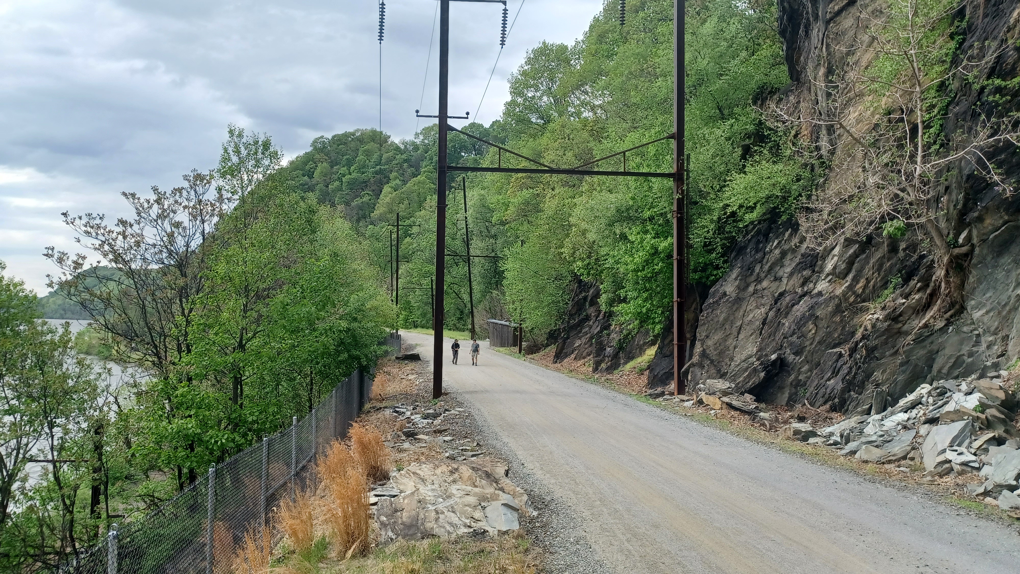
It became known as the "Enola Low Grade Line" because of the low grade changes and the fact that it re-joined the original main line over by Enola on the west side of the Susquehanna. Much of the line to the north is still in service today, but the segment from Turkey Hill to Atglen was abandoned in 1988, and torn up in 1990.

It was a comfort knowing that we were going to have this much nicer walk back without having to worry about traffic, and that we could do the other segment in the colder months.

It was a perfect, clear day with great views up and down the Susquehanna River almost immediately, at the impoundment of the Conejohela Flats known as Lake Clarke behind the Safe Harbor Dam.
We continued onto the trail past the parking area, and there were a surprising amount of people out.
The overhead caterary lines were never taken down when the railroad went out of service, and in fact, they are still used to power the SEPTA line to this day as I understand, used as a main conduit from the Safe Harbor Dam.
 |
| 1940s Shuman Collection |

As we continued ahead, there was a caboose parked on a segment of track to the left. It was originally New Haven Railroad caboose #23832, out of Connecticut. It was painted in 1914 era Pennsylvania Railroad colors. There is some argument that comes from rail fans about the authenticity of old rail items placed with different, inauthentic colors, but its nice to have it there anyway.
 |
| Pennsylvania Railroad Museum Collection |

A little further ahead, there was an observation platform along the left side of the trail which provided some views out along the Susquehanna, up and downstream, without having the chain link fence blocking the way.

We continued pleasantly ahead, and there was an old shanty structure to the right left over from the railroad days. These are cool to see, and they are all accessible. No graffiit inside, which was also cool. The majority of those using the trail at this time were Amish and Mennonite, so they'll not be the kind to be vandalising. Several families went by us, dressed nicely in dresses, and collared shirts with suspenders.
Ahead, we came to a spot where there was a major rock slide incident in 2018. This happened since the previous time I had walked this section. I'd done it once before with Jillane as part of a trip out that way before that time, and we covered from Martic Forge to Columbia (much of the later part in the dark).
 |
| Library of Congress |

We continued along, and there were pretty purple blossoms on the river side.

Soon, we approached the crossing of Mann's Run, which we crossed earlier on Turkey Hill Trail. There is a scenic little waterfall on the left side of the rail bed here, but just as interesting is how this and other streams make their way out to the Susquehanna without damaging the earlier Pennsylvania Railroad tracks below.
The stream flows beneath the railroad bed, then goes out onto a sluice that bridges it out and across the tracks below, then dumps it off of that into the Susquehanna. I've not seen anything quite like this setup anywhere else.
 |
| From my 2015 trip |

Some of the Pennsylvania Dutch kids we saw pass us earlier, a group of young boys, were all sitting out on the edge of the sluice ramp bridge as we went by it.

We passed by some more really nice cliffs, and then came to another of the little concrete buildings with a pavilion and benches nearby. The sky was clouding over somewhat, and beautiful striations of the sun passed through.
We came upon another observation platform, this time on the right side of the trail which meant it was closer to the edge and provided a different view of the Susquehanna up and downstream.
After this, we came upon a rockfall alarm system similar to what I had seen on the Lackawanna Cutoff in NJ, near the Roseville Tunnel. There were apparently called Slide Fences, and when a rock breaks a fence section, it turns a signal along the line red.
 |
| My 2015 trip |


The Safe Harbor Dam was completed in December of 1931, and is still apparently a main power source for Amtrack. Or maybe it was SEPTA. I forget which one honestly, maybe both.
We pushed ahead from here with continued good views of the dam below, including the giant bay door through which rail cars used to be able to reach. The striations of the sun got even more brilliant over the power plant section.
 |
| 1930s, John Barriger III image |

Just ahead was the Safe Harbor Trestle, a magnificent curving structure with combination deck truss in the center, and deck girder on the outer spans.

The bridge spans the confluence with the Conestoga River and the Susquehanna, and just below, the earlier 1877 line crosses directly parallel on a deck girder bridge that was built around the same time, because its predecessor was lost to flood damage.
When we reached the edge of the bridge, there was an elevated overlook area to the right a bit. I pushed Ev up onto that, and then I climbed up above him just a little bit higher for a better vantage point from which to take some then and now photo views.

I had an early 1930s view from the Paul Hartline collection from the top there, as well as another from the Shuman Collection in 1940s, Pennsylvania Railroad Museum.
After I climbed back down, I took several more then and now compilations featuring the bridge, using photos by John Barriger III from the 1930s, Library of Congress shots from 1988, and finally some of my own shots of the site I had taken in 2015.


When I had first visited here at that time, the bridge was not yet decked, but the trail was oddly finished to either end. It would have been easy enough to get around the fences at the time, but we didn't bother with it. In retrospect, we should have, because it would have been pretty awesome to see before it was done up. I just went out enough to get some shots.

Jillane and I came from east to west, and so we had to climb down the east side, cross over the Conestoga River on the 1931 pony truss bridge below, then climb back up rather steeply on the other side, by way of some rocks and a set of stairs, to get to the next bit of trail.
When the right of way was turned into a trail, the railroad actually funded some of the cost of the development, with a stipend of money that was given to each municipality along the way to re-deck the bridges and such. The Safe Harbor Trestle turned out to be a complicated thing, because it sat between two townships. Neither township, as I understand, used their funding to deck the bridge and instead for other projects, and so this bridge sat unused for about thirty years.
The bridge was recently re-decked, and I wasn't originally planning to cross it on this hike, but it is one of the things that made the hike that much cooler. The views from on top of it were stupendous.

The day I had hiked this with Jillane, it was incredibly foggy, so we couldn't see much of anything. That was all the more justification to walk the entire section again. It should have been the reason to just walk over the trestle, because no one would have been able to see us really. But we didn't do it.

There were outstanding views of the river, and also great views of the substation and up the Conestoga River. We could see about where Lock 9 on the Conestoga Navigation would have been.

Once we got to the other side of the bridge, I was anticipating the climb down that I had to do with Jillane when we hiked this before.
It was nothing like before. There was a lovely crushed stone trail down the side of the bridge once we got to the other side. It was mostly easy walking where I could push the stroller, save
for the lower part of it that is now stairs. My friends helped to get the stroller down that, and we were good to go.
The walk down afforded us great views of the superstructure of the bridge.

We came out to the Power House Road, and the 1931 pony truss bridge, which still has rails in it from the days of the construction of the power plant.

I have heard that the rail spur was also used to reach the Susquehanna River to dredge coal from far upstream in the anthracite region.
The tracks went to the substation just behind us, and across toward the plant. We decided to walk across the truss bridge, beneath the bridge we just crossed as well as the earlier line.
Once across the bridge, I was rather shocked to see something about visitors using the walkway. It looked as though the Safe Harbor Dam was open for visitaion!


I was quite surprised with this, and it seemed like a big opportunity we had to take.

The walkway itself was really cool; it was the railroad tracks, still in place, with pavement placed between the gauge, and pedestrian simples and "walk way" painted in it.
We moved on down the tracks to the gate at the entrance to the dam, and there was a guard and shanty. We turned left over the road, and walked right by him with warm greetings. This was totally allowed.
I was also surprised that there was nothing reading that there was no photography allowed either. The site was secure, but it wasn't some outlandish thing like we would have in New Jersey.

There was a giant grey, four wheeled machine with a window and cab on top of it, which moved back and forth across the walkway along the dam by way of two very broad gauge rails. There was a beam and chains for some sort of securing hoist attached to the bottom of this.

This place was not totally crowded, but there were a good amount of fishermen out on the dam. I hurried all the way to the end, as far as I could possibly walk, which felt like it was in the middle of the river. Actually, the walkway there didn't lead any further than one quarter of the way across, but it was still incredible to be on. I never thought I could be.
The view of the two railroad bridges over the confluence of the Conestoga River was incredible. It is certainly one of the best vantage points to see these structures.

I was beside myself with joy to have walked out to where we did. I don't know that the dam is regularly open to the public, but it doesn't seem like something normal.

We made our way back out the way we had come, along the paved through tracks, back beneath the rail bridges and over the pony truss.
I don't know where exactly lock 9 was, but I had a look around. There was a metal sign about the Port of Lancaster on the canal, and we turned left on an unpaved road that went to the left, away from the paved road and past a canoe launch.
The paved road continued through a section of trees, the pavement stopped, and it continued parallel with the Conestoga River upstream into Safe Harbor Park.

As we walked and got closer to the river, there was evidence to the left of what might have been the towpath along the edge, as a sort of level shelf that was obviously dug in.
This was a nice, relaxing little walk back to where we had started. The others helped to shuttle drivers back to Columbia, and I was able to start heading home from the Safe Harbor location.
I very much look foward to visiting the site again, as part of the Conestoga Navigation route, as part of the Atlgen and Susquehanna, and as connection to the Conestoga Trail. There's so much more to explore throughout this area, and it's been mostly great to bring Ev along on them.


No comments:
Post a Comment