

Hike #1571: 9/24/23 Southwest Staten Island Loop with Diane Reider, Justin Gurbisz, Evan "Joe Millionaire" Van Rossum, Galya, Serious Sean Dougherty, Jenny Tull, and Everen
This next one would be another great Staten Island adventure, this time building off of what we'd done just a little under two years ago, in the Fall of 2021.

The hike came about just the previous week. We had finished the regular Sunday hike in Rocky Hill NJ, and over dinner, we were discussing what next week should be.
It's getting kind of rare that I don't have anything decided on by that time, but I had nothing.
In the parking lot after, Serious Sean, Ev, and I were talking about what we should do, and Sean reminded me that we still needed to go back to Staten Island, specifically for the huge mess of parks on the south side that stretch down to the Raritan Bay.
We had hiked there on Halloween 2021, and it was just great. We'd had such a great time, but that one ws focused more on the beach. We never got around to doing much inland beyond what we had to in order to get around impassable stuff.

This time, we could post almost the same hike, and make it all about that inland stuff, and when we were at about the mileage we wanted to get, we just head to the nearest train station.
 |
| 1940 |
There are frequent stations, and they all go back to the Tottenville Station, which has a walkway directly from the platform to Bentley Street, which would be our meeting and starting point.

Saturday didn't turn into any kind of disaster either, and was more like a weak spritz all day long, so I figured Sunday would be fine because it would be intermittent rather than rain all day, as per Accuweather.
 |
| 1914 |

The meeting spot was formerly the spot of the Tottenville Ferry. This ferry was established by local entrepreneur Henry Hogg Biddle in the 1850s, between Tottenville and Perth Amboy NJ.

Biddle also established Biddle Grove, an amusement and resort area, on the north part of his property.
The Staten Island Railroad was established at this point in 1860, and terminated with a walkway right to the ferry slip at the end of Bentley. I understand that eventually, the railroad operated the ferry.
The first section of the Staten Island Railroad operated between Tottenville and Annadale. The original station at the site burned down about 1929, along the the platforms on both sides and several rail cars.
The ferry remained in service at Bentley Avenue until 1963. Not much remains of the ferry slip on the Staten Island side. Beyond the barricades, there is just busted asphalt falling off into the Arthur Kill, and there are a few bits of wood stretching into the water a short distance.


Slowly, the others started showing up. I used some of my extra time to get some of the stuff in my car organized, because it has been becoming quite a disaster.

Diane showed up first, followed soon by Jenny, then Galya and Justin.
While I was getting my stuff together, everyone wandered around with Ev looking at the waterfront and the end of the rail line.
The Staten Island Railroad train sat parked and idling just beyond a chain link fence to the right, and Ev was just enamored with seeing it. I'd gotten him excited all day about seeing trains from when we left the house. He'd just watch it and occasionally let out a "choo choo".
Once I had everything out of the car that I needed, the rest of the group showed up while I was running around setting up then and now history compilations of the former ferry site.


Joe Millionaire showed up last, and as he started meandering the area, he realized that there were cherry and grape tomatoes growing in the bed of plants at the station! Most of the red cherry ones had gone bad, but the yellow ones were quite excellent, so we ate several of them.
I tried to get Ev to try one, but he was enamored with everything, including some shells that were left in a heap along the south side of the road.
Once we were all set to go, we began walking back Bentley Ave to the east, and then made the first right turn onto Arthur Kill Road, a dead end street.


At the end of the street was the first park we'd go through, Tottenville Shore Park. The small park did have a small foot path through it, which headed inland to the left, and emerged on Hopping Avenue.

We turned to the right on Hopping, and continued to the south to Amboy Road where we turned left.
Along the way, there was an awesome, giant tree along the road, which I think was a Cottonwood. I suspect it was maybe as much as 180 to 200 years old.
I had intended to make the next right turn on Saterlee Street, but I missed the turn, and so we made the next right on Craig Avenue.
We followed Craig to Shore Road and then turned right. This brought us out to Satterlee Street again. We turned slightly right, and then left at a driveway entrance, parallel with Stairway Street.
 |
| 1950s |

At the end of this drive was the lovely H. H. Biddle House, with rare Greek Revival Doric columns on both ends, atop the bluff that once overlooked the Arthur Kill to the west. The area is now pretty much overgrown with trees, so there is no longer a view.


The home was built between 1840 and 1855 on the large tract of land that stretched to the Biddle amusement area where we had started walking.


We headed to the east from the building, and then out to the the covered pier out along the Ward Point Bend section of the Arthur Kill, with good views up and downstream.

Ev was happy to walk much of the time so far, but I had him in and out of the stroller very frequently. It had already rained and stopped raining several times for such a short time period, and fortunately he was happy to jump in the stroller rather than get wet each time.
We waited here only a few moments, and then headed back uphill slightly on the access path, and then turned to the right on a crushed stone surface trail.
We had already walked the beach below this point in October 2021, so I was quite happy to be doing the rest of the trails we hadn't seen that last time.

I didn't have Ev with me on the 2021 hike, and so this was a more appropriate route for him anyway. It started raining, and so I put him back in the stroller once again in this stretch.

We turned right at the next trail intersection, and we weaved closer to the beach. The heavy canopy of deciduous trees gave way to an open beach plant environment.
We turned right at the next trail intersection, and this section was once a through road known as Surf Avenue. It used to go on through to Brighton Street to the east.
The road had washed off into the bay at some point ahead, and all traces of the old paved road had disappeared. There was a small stream that flowed where the road went, and a single plant bridge to span it. Sean got on the board in front of me and carried the front of Ev's stroller so we could carry him across it safely. From there, we were on the beach for a bit.

This area where we came out is actually the southernmost boundary of the State of New York, as well as of course New York City.

We continued along the beach to the east, and I pointed out the waves crashing to the shore to Ev. He seemed quite mesmerized by everything. This was of course different than anything we had hiked together before.
We continued along on the beach for a bit, and I looked to my phone GPS aerials to where Surf Avenue cut back inland a bit again. I waited just a little too long, but there was another mowed trail that accessed it just ahead.
The problem was, there was a white sort of bagged sea wall thing in place. I tried to step up it, but it was too slippery to climb up like that. It wasn't hard, but I had to use my hands, which meant getting the stroller up would require some help again.

I climbed up first, and the group picked up two sides of the stroller, and I grabbed the end to pull it on up, and we were on our way.

I tried wiping my hands off on a blade of some sort of grass, and it ended up being really sharp and painful. I had to try to find other leaves to get the sand off of them. Some Japanese Knotweed wasn't doing the trick, but the mowed grass ahead on the trail did.
We followed the mowed trail to old Surf Ave again, and turned to the right, east.
We turned left on Brighton Street to the north, and reached Billip Avenue. We turned right there, and followed the street to the east for a bit. I let Ev out to walk again, and he was doing well staying close to us, and not running into the streets at crossings.

When we got to the next intersection where we had to turn, about four blocks to the east, at Loretto Street, Google maps showed me there was a path into an apartment complex straight ahead.

We headed onto the concrete path next to a pool or ball court or something, and it was gated and locked at the end. We had to turn back, which was awkward going by people's glass doors.
We continued back out to Loretto and headed to the north for a bit.
My intention had been to follow several development paths between sections of a development that would keep us more off of the main roads, but there was no good way in until we got a little further north.

Sean and I had been talking about the next piece of property, known as Hybrid Oak Woods Park, as being the next we would checkout, but there were no trails on Google maps, no trails mentioned on the official city park maps, and none even on Alltrails app.

I figured there must not be anything. I even checked Google street view and saw nothing.
Because I had the stroller, I figured we were better off just sticking to the roads in the uncertain areas anyway.
We continued north, and eventually turned to the east through one of the apartment complex areas, then to the north on a development path, and down a small set of stairs. A right turn brought us out to Sprague Ave, and we turned left to reach Hylan Blvd.

We turned right here for a bit, and then passed by the Tottenville Pool and playground area. If it hadn't been raining, I would have let us stop for Ev to play.

We got a picture with the big Tottenville sign, since Ev is a "tot", and it seemed like a cute photo to get. There was also a couple of arrows and "You're Cooler" written on the walls at the pool area, so I had the group stand by that to look cool.
We continued ahead a bit more, along more of Hybrid Oak Woods, and only saw one slightly clear trail route, but nothing marked or official.
We turned to the right when we got to Bedell Ave and headed south toward the bay area, into a rather new development.

Near the south side, we turned left into a new development road known as Ottavio Promenade. There were some new houses being constructed on some of the last couple of lots, and then a gate at the end of the road on the east side only, which would lead to Page Avenue.

We reached that, and turned right, which brought us into an annex property of Conference House Park.
Two NYC parks vehicles were parked at the end of the lot. One was a sort of small administrative vehicle, and one truck.
I had looked at this a bit during the week, but Sean reminded me that there was a good path shown on Alltrails that leads from this parking area, up through the Butler Manor Woods, to the Mount Loretto area. It looked like a perfect connection for us.

Sure enough, when we got to the beach access, off of the other side of the lot, there was the trail leading into Butler Manor Woods.

This woods was once part of the Butler Manor Estate, a 65 acre tract that included the main manor house, an earlier Butler family house, several cottages, a race track, gate keepers house, and more.
The property and home was that of businessman Elmer T. Butler. The main manor house was designed and built in 1908-09 by New York Architects Lamb and Rich, who also designed Theodore Roosevelt's home on Sagamore Hill. The home was the only building remaining in NYC designed by these architects.

Sadly, the beautiful Neo-Classical style Butler home was demolished around 2010. It seems that pretty much every building that remained of the estate were also destroyed. It seems that the earlier Butler home also was destroyed around the same time, more a Victorian style home at 485 Butler Blvd (the later one was at 500).

That entire neighborhood seems to have been knocked down in favor of new, ugly homes by comparison. Reading into it, the Butler estate probably had much greater value as more aesthetic property, but it was all let go. Each of the homes standing today at those addresses are cookie cutters with no character.
The trail was pretty nice. It had no markings that I remember seeing, but it was pretty obvious where to go. There was a fork in the path where one with sticks lining it went straight ahead, probably into that new development where the mansions used to be, and the one we wanted went right.

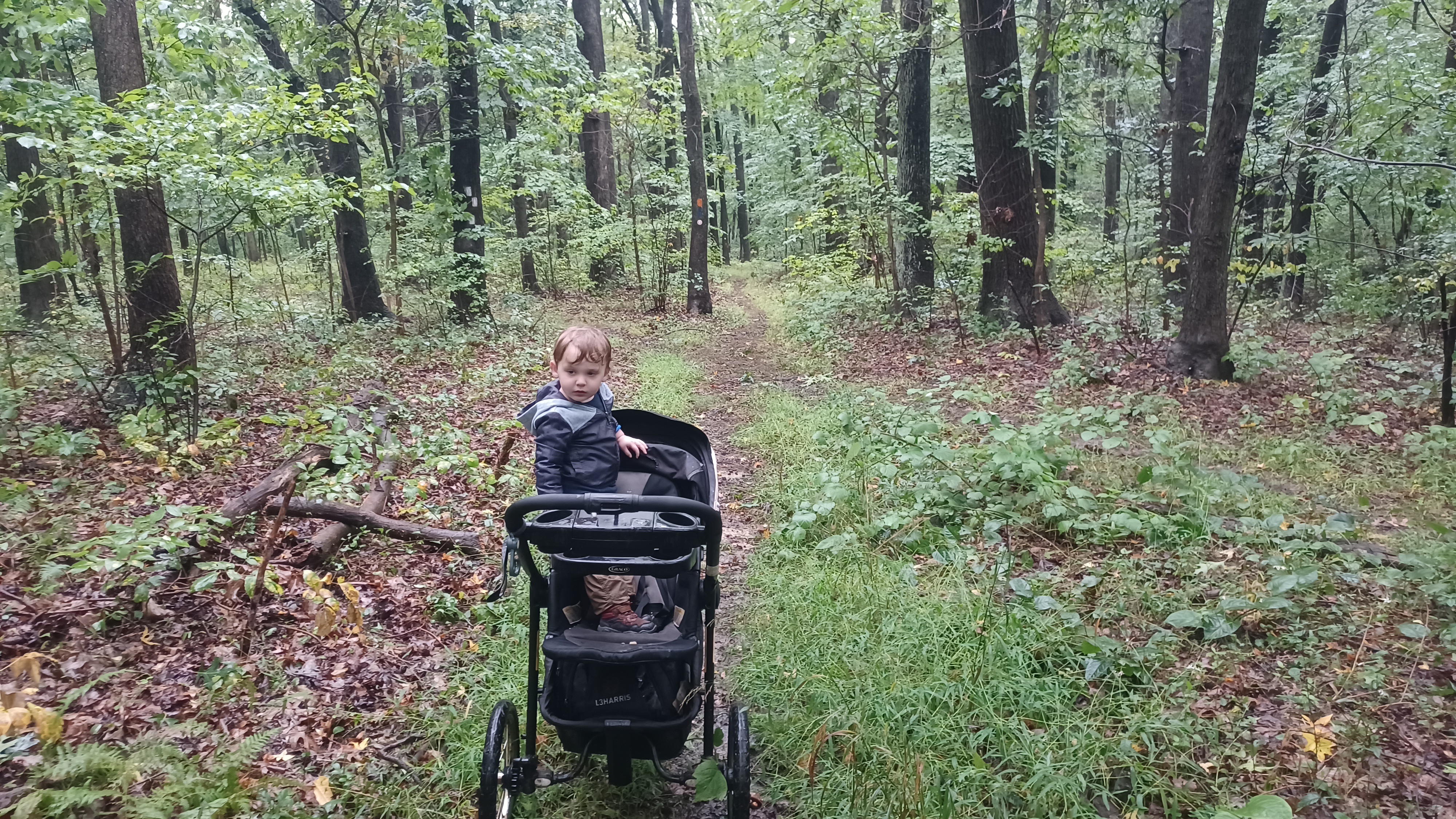
The section had quite a few tree roots, and the weather started getting better, so I encouraged Ev to get out and walk a bit. He was quite happy to get out, and did very well walking from here.

We headed through nice woods, passed a pond on the right, and then hit some old woods roads. I think one of these was the continuation of present day Richard Ave, or maybe Butler Ave. We crossed a small stream, as well as several other wet areas that the group helped to lift Ev through, and eventually skirted some new home properties before emerging into the edge of a field. This was the start of the Mount Loretto Unique Area property.
This was originally the Bennett Farm, but it was purchased by the Mission of the Immaculate Virgin, which was started by Father John Christopher Drumgoole in the 1890s. He named the property Mount Loretto for one of the nuns who worked with him at the original Mission in Manhattan.
The new orphanage was established on the property in 1883, and remained in use until 1992. It sat vacant for the next several years when two teenage boys started the fire that gutted it around 2000. The shell of the building was later demolished.
In 1999, the State of New York along with the Trust for Public Land purchased 145 acres of land here from the Archdiocese of New York to create the public ground.
We continued along the nicely mowed trail, and we could see the steeple of the church building that the Archdiocese still own a bit to the north. It was obvious that stuff used to stand out through this area, and that it had all been cleared out. I'm not exactly sure where all of the buildings stood exactly.

The facility that used to stand here was once the largest orphanage in the entire state.

The mowed path led us to the Cunningham Road, which is now used as a trail in the Mt Loretto Unique Area. We turned to the right, and there was a building that is apparently used by NY DEC.
We continued to the left, and there was a historic marker that told us some about the property. Just a little beyond here, we came upon the Shrine of the Immaculate Virgin. This is a stone masonry niche that was constructed in 1935 to face the girls dormitory building on the property, so this structure is the only thing I know to go by for exactly where any of the buildings stood.

The place was loaded with all sorts of religious trinkets, and memorials to lost loved ones. Photographs and funeral cards were all over the inside of it.

Ev got inside and was fascinated with all of the little things in there, and we had to make sure to let him know he had to leave them there. He was really quite good about it all.
From here, we came to an intersection to the east, and there was a little pavilion straight ahead that looked to be a great spot to take a break. To the right, there was a wooden observation platform with a view out to the Raritan Bay. From it, we could also see down the bay to a beacon at the base of the high moraine. This tower Justin and Sean climbed to the top of the last time we were out there in 2021.

We had a great little stop here, and Ev pretended to fly around in the strong winds like he was a bird or an airplane.

The rain had pretty much stopped here, and the wind wasn't dangerous, but it did have a little strength to it to add a chill, so I put a jacket on Ev anyway.
After our break, we continued across grass to the east, and then got on Monsignor Road heading gradually uphill to the height of the land along the shore.
The original Monsignor Road was just to the right of the current road, but the constant erosion of the bluffs here have caused some of the original road to collapse into the bay.


 |
| 1885 |


I could easily have gone over and gotten the shots of the building I wanted to get, but I'd pretty much talked myself out of walking over there for it.

Then, Justin reminded me "you're here now", and I woke up and realized that taking a couple of photos for a second was not a really big deal, and it was actually promoting a historic site, so I went and got them. They actually came out pretty good.
From here, we could barely see across Monsignor Road the mowed trail that leads downhill on the other side of the moraine.
We walked across and down that, and Ev did a great job walking on his own, fast all the way down the hill without falling.
At the bottom, the trail splits. I had considered that we might go left and start heading back in this area, but the mileage we were at was not nearly where I thought we might be yet, so we turned right.

The trail took us along the right side of a meadow area, and there was an old pond just inside the trees to the right as we were heading gradually downhill.

At the bottom of the hill, we headed out from the woods and onto the beach once more. It had started raining just before this, and I asked Ev if he wanted to get back in the stroller before he got wet. He ran right over to get picked up.
We made our way out to the beach, just as the rain started picking up. Not to repeat the last rain problem, I put my phone in a good pocket in my rain jacket before continuing.
The beach was strewn with all sorts of rocks and debris that had washed ashore. It made it a bit harder to navigate with the stroller through it.

For the most part, the stroller on the beach wasn't so bad because I could just stay closer to the water break where the surface was harder. When I got a little further away, it got hard to push.

A stream flowed into the Princes Bay just where we reached the beach, so I had to go to the right a bit, down across, and then to the left.

We continued along the beach for a while, and soon reached the Dorothy Fitzpatrick Pier, at the access on Sharrott Avenue. Ev and I got there first, so I let him out of the stroller and asked him if he wanted to run up onto the pier. He wasted no time and hurried up onto it.

The views was of course great, and I got a pretty close comparison of a photo I took on the previous hike toward the Princes Bay Lighthouse and bluff looking to the west.
There are fish statues at the entrance to the pier, and an Osage Orange tree. Ev tried to feed an Osage Orange to one of the fish heads, and then brought it out to throw it off of the pier.
After we came back off of the dock, on his own, he climbed up and tried to ride one of the fish statues. I couldn't believe he got up there by himself to try to ride it.


We made our way from this point up Sharrott Avenue. To continue on the beach at this point with the stroller would be extremely difficult. Last time, at high tide, which was coming in, it was very tough to walk it without anything to push, and with stronger than average waves, I wasn't risking.

We went up the road to Hylan Blvd again, and crossed directly. Just ahead, I was looking to see if there was an access in to the Resurrection Cemetery. There was none here, so we just continued down the north side of Hylan for a bit, until there was an opening to the left.
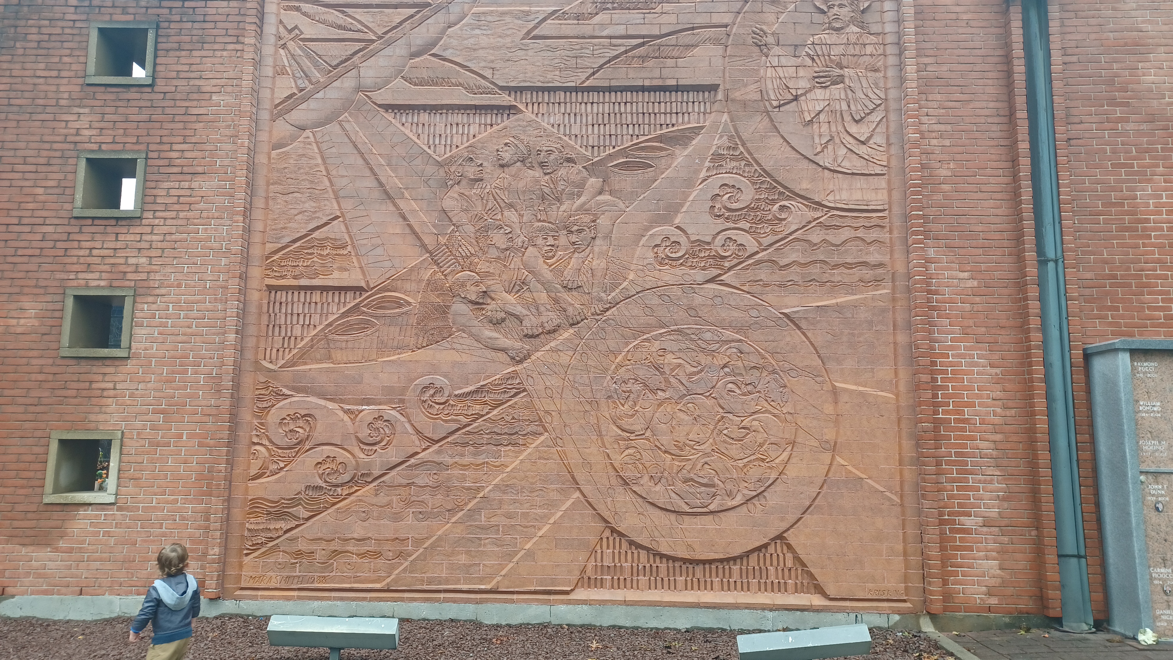
We cut to the left into the cemetery, and there was a nice pathway to a statue of a bearded man holding a child. Serious Sean got a photo of me holding Ev up next to the statue at the end of the path, which I've included in this journal.


We soon reached Woodvale Avenue, and turned right back out to Hylan Blvd again. We crossed, and then continued along the road heading to the east.
It wasn't very long before we crossed the Lemon Creek with some very nice views along the road.
We continued to Richmont County Savings Bank, turned right through the parking lot and then right onto Seguine Avenue. We had walked this bit back in 2021, but this time we'd go a bit more direct.
Along the way, to the right, the Seguine Mansion was off on a gated property. We'd seen it before, but were not able to get close. It has a private caretaker, but is park property. Neither of these times we'd gone by was it open for tours.

We continued down the road to Lemon Creek Park, and cut in immediately. We turned right on a crushed stone path along the north side of the park, which weaves around and then crosses a long foot bridge over an inlet.
On the previous hike, we went back out to the beach here, but it is kind of rocky at first, and so we stayed on the crushed stone path to a pavilion lined with little dolphin things around the awnings.
We came back out to the lower end of Seguine Ave after waiting in the pavilion for some rain to pass by Ev fell asleep while we were walking into the Lemon Creek area, and remained passed out as we walked out onto the beach to the south.

From there, we just continued on the beach for a good distance. It was again rather difficult at times with all of the debris that has come up onto the beach.

The rain also didn't make it much easier, and the wind. Fortunately, Ev slept through all of this and had the rain cover over the stroller, so he didn't notice any of it.
We went all the way around the southern tip of Seguine Point, which probably wasn't at all necessary, but even in the rain it was a pretty walk, and continued east. When we reached the Holten Avenue Park access, where we probably should have entered, I thought we were further than we actually were.
The beach was basically a causeway heading to the east to Wolf's Pond Park, where we were passing between the bay and Wolf's Pond itself. Just beyond this, where we came back up into the park, we figured we would stop and use the restrooms that look like above ground bunkers.

Amazingly, these restrooms were closed. I was surprised, because they were open on Halloween two years prior, and that was the end of October vs the end of September.

We took a little break under these things, because they sit up high on these stilts above the water and tide surge level.
Whe the rain let up a little bit, we walked along the nice surfaced path to the north a bit, along the big parking lot, and then to a trail at the far side of the lot.
This was a natural surface trail leading into what seemed to be deep woods, which I always love on Staten Island. One would never think the places we were going were part of New York City.
Wolfs Pond itself became more of a regular stream inlet, though still a little wide as we headed into the woods and climbed to a greater height of land.

I was surprised to find the trail system blazed with standard blazes, and proper turns, with paint on the trees. I knew the Staten Island Greenbelt was blazed in that way, but it was nice to see something familiar and easy to follow.
We followed the trail closest to Wolf's Pond, and then its associated tributary to the north. The stream became narrow, and the trail did too, with more tree roots in the way.
This narrow bit of park, both Wolf's Pond Park North and South, on either side of Hylan Blvd, as well as I believe a bit of Woodhull Park north of that, was a plan by Robert Moses from 1941 to 1970 known as Wolf's Pond Parkway.

A major highway connecting Rt 440 to the beach was planned and eventually deauthorized. The present day Korean War Veterans Parkway is part of the planned Richmond Parkway that would have gone through, but the Staten Island Greenbelt now takes up much of where it would have run.

We continued north to Hylan Blvd. There was a spot with a stone hope or creek ford to the left, but with the drizzle and such I didn't want to chance trying to carry Ev in the stroller across it. He was starting to wake up due to the bumps of the trail conditions, but I still didn't want to try anything crazy when we could just go up and use the road bridge.
When we got to the road, I was surprised to see that a white blazed trail we were following actually went left on the road anyway, and then left again on the other side of the stream into the woods.

We followed the trail south and uphill a bit more again. It was sometimes a bit difficult to get the stroller through due to tree roots, but overall not that bad. The white trail turned to the right near the top of the hill, and another trail turned left. These other trails were blazed as well, but I haven't seen a good map of where they all go. We just kept to the white one, which brought us on the slope above Hyland Blvd, and then down to the corner of Hylan and Holten Ave.
At the intersection, the trail blazes led directly across the street at the crosswalk and then into the woods to Wolf's Pond Park North. I was glad that it was a direct connection, because Google maps seemed to show I would need to go to the right down the road first.

These woods on the north side of the road were undulating terrain, with more side trails. We remained on the white for a while, which made a left turn onto an easier old woods road.
We continued on this route through pleasant woods, heading north, until we came to a more major fork where the white went up a slight hill and I think it was orange went right.
I started going up the hill, and Sean was watching his Alltrails app and found that the turn we should take was to the right. I wanted to try to get out toward Tottenville High School.

Fortunately, there was a side trail at the hill connecting over to it so I didn't have to really backtrack. I pushed the stroller along this route until eventually we came within sight of the high school buildings.
A trail went to the right, and another went to the left, parallel with the school property. There was an unmarked social trail to the right that led out to the lot for the school.
We made our way out to Chisholm Street, where there was a little pond at the spot where the road made a ninety degree bend. I decided the route we would take would be to the north here.
Galya was pestering me all day long about stopping for lunch somewhere, but I didn't really have any plans for anything in particular when it comes to that, just whatever came up.
We could have stopped at a place a couple of hours earlier, but the problem was it would have meant over an hour of walking only on the roads, and I didn't want to do anything that boring just to get something to eat. I had enough snacks for Ev, so he was good.

We settled on stopping for food at a place near the north side of Wolf's Pond Park, and so I saw Ciro's Pizza in the community of Huguenot.
We headed north on the road, and Serious Sean found a big mess of balloons just in the woods by the little pond we went by. He picked them all up and started carrying them with him.
A woman came jogging by on the opposite side of the road from us, and so Sean thought it would be funny to run behind her holding the big mess of balloons. That would most certainly freak her out, I'd imagine, but she didn't seem phased. I suppose he's probably lucky he didn't get pepper sprayed!

We turned right at the north side of the school campus, and continued out to Amboy Road, where it goes beneath the Staten Island Railroad tracks. We turned right, and headed to the east.
On the road, we went by the Reformed Curch of Huguenot Park, where they had their sign outside saying to "Be part of God's Havest", as if it were made by phonetic spellers from Boston.
We turned left on Huguenot Ave, and Galya and Joe Millionaire immediately went over to a pizza place, but it turned out there was no indoor seating. I was ready to just sit outside or whatever, but then the group found a Mexican place across the street in a strip mall. I don't know what the place was called, and it is not coming up on Google maps so it may be a pretty new thing.
We all went in, and Joe Millionaire and Galya soon came over and sat with us. I ordered a burrito, which Ev and I shared, and it was quite delicious. I was very happy with it.
We sat for a while, and eventually made our way out and over the railroad tracks on a bridge at Huguenot Station. Serious Sean went into a nearby store, and emerged with a bottle of Double Dog IPA by Flying Dog brewery, which isn't as good as the Double Dog 18 I usually drink, but it's still a pretty good IPA, so it was one more to get me through the rest of the hike.
This was one of the original station stops that opened in 1860 on the line. It was previously known as Huguenot Park, but MTA dropped the park part. Prior to that, the settlement was originally known as Bloomingview.
We turned left on West Terrace, and made our way to Woodhull Park on the left, which we just passed through on a brief side path, and then continued along Drumgoole Road east from there. This road was named for the same religious leader that started the orphanage further to the south, but at the time I did not know why his name would be applied to the area so far north of this signature property.
We turned to the right when we got to Foster Road and crossed the Korean War Veterans Parkway, and then turned left on Drumgoole Road West. In a short while, we came to the intersection with Lenevar Ave, and a trail entered woods parallel with Drumgoole into Bloomingdale Park. We walked through the south side of the park for a bit and emerged at the corner of Drumgoole and Maguire Ave. We turned left here and went under the Korean Veterans Parkway, then turned right on Drumgoole E.
There was a very short bit of this that had no sidewalk amazingly, so I had to hurry through that because people drive insane, but it didn't last long.
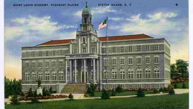
In a short bit, we turned to the left into the entrance lane to the Yeshiva of Staten Island, a Jewish school for boys.


The building struck me immediately as very stately and beautiful. It was certainly not new. This had been around for a while. However, when I looked up the Yeshiva of Staten Island, they had only been active on Staten Island since I think 1966. This building was certainly older than that. I became very interested in this.

I could not find much of anything on the building, until a forum told me that it was an old Catholic school originally. That gave me something more to Google.
I soon found the St. Louis Academy of Staten Island. This was an all-girls school that moved to the location after starting out as co-ed at a nearby location.
The only thing I could find was in a Staten Island periodical called Staten Island Live, an interview with an alumni named Lynnie Fass, who would have been the graduating class of 1971, but the school closed that year.
Nowhere else could I find any history of the building. Fass stated in the article that the school was built "during the Great Depression", under the Sisters of the Marianites of the Holy Crosswhich is kind of surprising because no one had money then, and that it started out as a boarding school. It remained a boarding school until the fifties. Classes started phasing out in 1965.
 |
| 1896 |
This started making more sense that the Drumgoole name was applied to the road nearby. Certainly the religious leader was involved with the development of the school and its 12 acre campus.
The Yeshiva took over the building some time into the seventies, under the son of the founder of the famous Yeshiva of southern Manhattan.
We turned right after heading toward the front of the beautiful building, and went up slope to newer buildings and a sidewalk that heads out to Bloomingdale Road. We turned left and followed that south.
Bloomingdale Road led us down to the center of the little community of Pleasant Plains, where we went into a store to the right to get some final snacks for the home stretch. I forget what I got for Ev, but there was a little something. I made lots of comments about getting diarrhea, and the store clerk seemed to think it was funny, and said something about me being a "funny guy", to which I responded I was very serious. He probably didn't know what to make of all of us.

We continued south and the road straight became Amboy Road.
The area was less developed, and on the south side of the road was more of the Mount Loretta property we had been on earlier.
At one point, there was an access road to the right leading toward the railroad. This was next to and partially on the former railroad spur that served the Mount Loretto facility. It remained in service as I understand until the early 1980s. Up to Amboy Road was owned by the Staten Island Railroad, which was controlled by the Baltimore and Ohio, and south of Amboy Road was on the property of Mount Loretto, and maintained by the railroad through some deal.

I didn't know we had seen the former rail spur when we were looking at it, but now I know that some of that right of way is now part of the trail system in the northern part of Mount Loretto. I was just thinking I have to tell Russ Nelson about it, since he'd done every rail trail in New York. It might just be one he hasn't done...
We continued west to a fork in the road, and went left on Amboy Road where Richmond Valley Road went slightly uphill to the right. A lot of the sidewalks through this area were suprisingly overgrown with lots of weeds. The Richmond Valley Station was just ahead on the right on a side road.

I thought up ahead that we might get on a piece of new trail to the right of the road, part of the Mill Creek Bluebelt, but it was fenced off and signed, so we couldn't get in.
We continued ahead on Amboy Road, and soon came to the Bethel United Methodist Church and cemetery on the right. There was a fence in front, but we were able to lift up a wall on the east side and steeply climb into the cemetery, which was surprisingly rather overgrown.
The church is still in use. The handsome brick structure was built in 1887, on the same site as its predecessor built in 1842, but burned in 1886.

The original congregation's church I read was located where the railroad tracks are today, but they moved to the current location and established the cemetery around it.

We turned to the right and headed north through the cemetery, then exited it to the left. At the end of the cemetery was the original site of the Nassau Station on the Staten Island Railroad. This and the Atlantic Station on the same were eliminated and replaced by the Arthur Kill Station, located right between the two locations, in 2017.
We turned right down Bethlem Ave and then left on St Andrew's Pl, where there had been a walkway down to the Nassau Station previously. We continued along the road to the west, and the sidewalks here were as badly overgrown as the ones we had passed by just a bit earlier.

We turned right on Arthur Kill Road, crossed over the tracks on the bridge, and then turned to the left on Ellis Street, with the new Arthur Kill Station on our left.

We continued walking Ellis Street from here, and when we got to just about the former site of the Atlantic Station, a train was coming by slowly up the track. Ev was mesmerized by it, and watched it go by.
The Atlantic Station opened some time between 1909 and 1911, specifically to serve the workers of the Atlantic Terra Cotta Company, so it was not one of the original stations on the 1860 line to Tottenville.
A pedestrian overpass was built for the station in the 1930s, and we just barely missed seeing it, because it was only demolished in 2022.

The Tottenville Station building soon appeared ahead. The handsome building looked to be a restaurant now. It was not the original station, as that one burned down and was replaced in 1929, along with both platforms and five rail cars. It was cool to see it was built back so nicely.

We went around the station and up onto the platform. We then went steeply up the staircase. I let Ev out of the stroller to climb, and we went over the bridge over the one set of tracks, then descended to the platforms in the middle.
There was a train parked on the left when we got down and Ev was almost read to run on board, but I made sure to stop him.
We continued on down the platform, and then out the exit to the former ferry site to Perth Amboy. It must have been something when this was an every day commute for some folks.

Before heading back to our cars, there were beautiful dusk views out over the Arthur Kill, out toward the bay, and up to the Outerbridge Crossing, the steel cantilever bridge between New York and New Jersey that opened in 1928.
I was happy to get a good shot of it like this at this time, because it's only a matter of time before they rip it down and build something new like they did with the Goethels Bridge just to the north.
The stroller held up really well, which surprised me because I had to add a lot of air to the tires, and I was afraid they were not going to hold for the day. They actually did really great.
The hike was really very relaxing for me, and having the ability to make up some as we went, and always have the ability to get out via public transportation, was really a great thing. Now, we've got several more Staten Island hikes we can pull off, because there are so many more trails in some of the parks that were new to us, and still several more that we haven't done at all yet.