

Hike #1572: 10/1/23 Wilkes-Barre and Nanticoke Loop with Justin Gurbisz, Brittany Weider, Galya, Robin Deitz, Red Sean Reardon, and Everen
This next trip would be another loop, this time starting where we'd left off on the Luzerne Levee Trail in Kirby Park, Wilkes Barre PA.

This ties together a whole lot of stuff, and also extends into some new ground. Of course, the Luzerne Levee Trail is pretty extensive, and while we walked a lot of it on two hikes in the past, we still had long stretches of it to do to the west of Kirby Park.
The levee system only stretches as far as a spot known historically as Edwardsville, and so beyond there we'd be onto something kind of new for us.
The former Bloomsburg Branch of the Delaware, Lackawanna, and Western Railroad has been of great interest to me ever since I saw that it was a trail for over fifteen miles just to the west of Nanticoke heading down the Susquehanna. I really want to get out there and hike that, so I figured we need to do the rest of it from Kirby Park as well.


We'll end up having to do more of it, because the branch went all the way from Scranton to Northumberland, not just Bloomsburg, and I still have to do much of it to the east of Kirby Park.

Still, this looked more promising than I had guessed it would be. It is not really formal trail in the stretch we would be following yet, but it is pretty clear and made for an excellent walk.
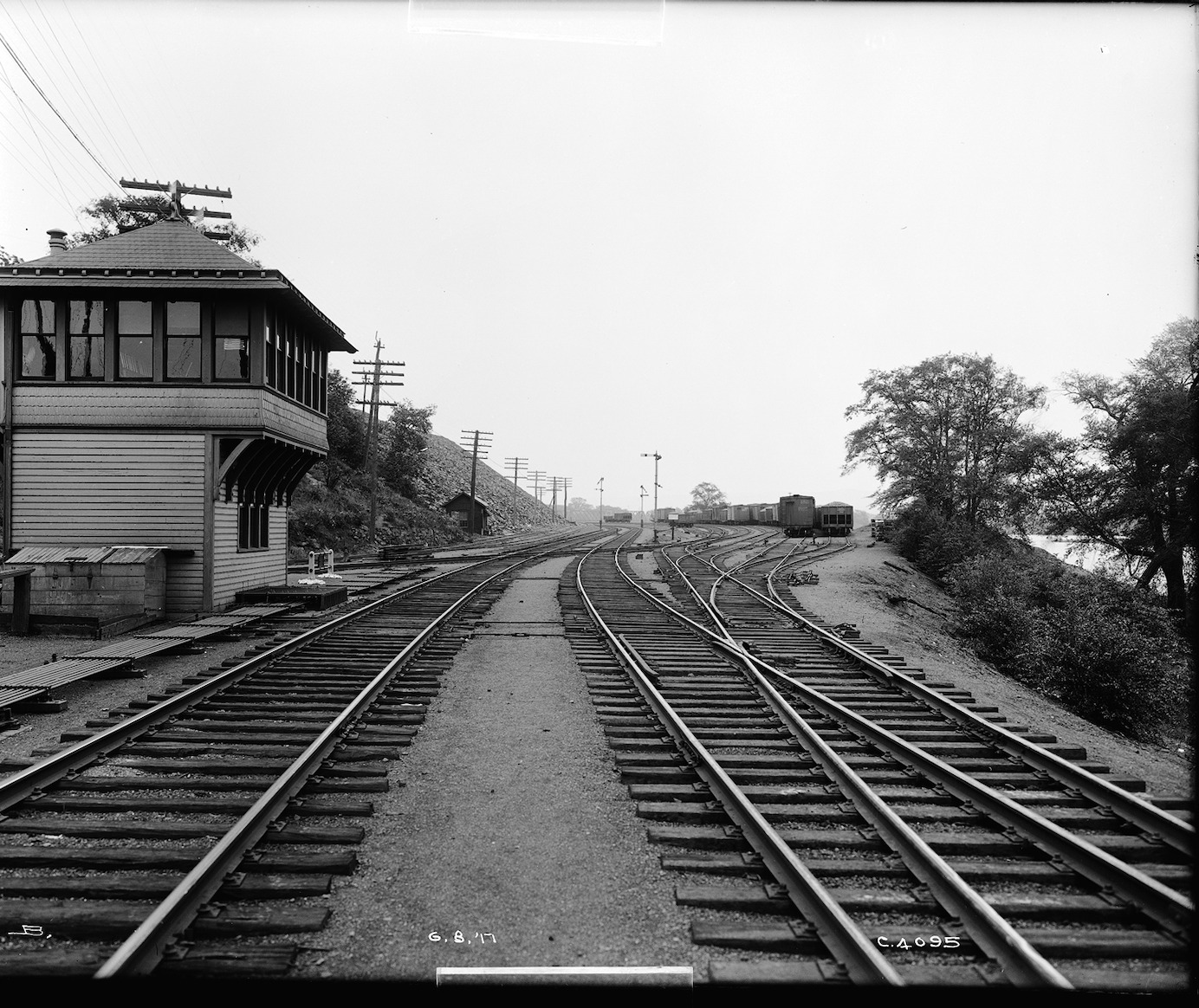
The meeting point was Kirby Park. We could go directly from there to the trail system I wanted to do.
I arrived early because my GPS was telling me it would take me longer to get there than it did. Because I was so early, set up a couple of then and now compilations on my way up. I got one at the Bear Creek Village area of the former Lehigh Valley Railroad branch that went through there, and then headed up into Wilkes-Barre proper where I set up another one of the old Laurel Line trolley going by the courthouse, just down the street from our meeting point. I still ended up getting there early.

We didn't take too much time getting ready. The best thing about the loops now is that I can just let Ev out of the car, change his diaper, and then let him run around and greet all of his friends in the group while I get the stuff together and ready to go.

I'm doing pretty good with all of this; it is a lot more to consider having a child on these hikes. Diapers, a bottle, drinks, straws, wipes, snacks. Things that I can just do without if I forget them, but not an option for him. Trying to make it all fit into the stroller, and considering if I will have to fold it all up to carry the stroller over obstacles at any point.
This one was looking like it would be quite an easy one for all of that.
We headed from the main parking lot area onto the paved trails in the park to the west. I'd never been further into the park that way, and was happy to see it had more very nice, giant trees.

We made our way along the paths out to the Luzerne Levee Trail, and then saw the path that went down along the Susquehanna.

Just ahead, the trail crosses over the railroad tracks adjacent to the Fish Island Bridge, also known as the Black Diamond Bridge. This was a jointly owned bridge built by the Pennsylvania Railroad and Delaware and Hudson Railroad in 1914, as the Wilkes-Barre Connecting Railroad. It is still active today.
The levee trail goes up to the tracks, but now it is fenced off. The grade crossing on the trail over the tracks was completely blocked. I figured maybe we could head down beneath the railroad bridge by taking the trail to the left. Ev was out of the stroller, and the others helped him on the grades, and we headed into the woods.

The trail started going the wrong direction. It was getting really muddy, and the mosquitos were getting bad. I didn't want to waste extra time going all through this area just to get past a few feet section of railroad grade. I decided we would head over and see if there was a way around.

When we got to where the trail crossed the tracks, now fenced, there was a guy drinking a fruity liquor drink, sitting on a block next to the tracks, in between the two sections of chain link fence. There were cameras up, but he didn't seem to care. They were probably fakes.
There were holes cut through the fence and people had just been going through anyway. The drinking guy just motioned us on through. I at first thought maybe he was a railroad guard or something.

He said there was a suicide by rail recently, and Norfolk Southern put the fence up over the trail. He said people were also crossing the bridge illegally.

This is really disheartening to see, because the trail has been there for a long time. Blocking this trail should have been illegal because it existed since probably Conrail days. Maybe per laws of Adverse Possession, they shouldn't be able to close it. But government does things differently.
I think it sends a bad example, when there are so many trail groups trying to take over active railroads to turn them into trails, and then active railroads are cutting off trails because of liability. Everyone knows that these fences are not stopping anyone, cameras are not stopping anyone, and the fact is crossing a railroad is a million times safer than crossing a road or even walking on a sidewalk. You can't steer a train. Certainly, you cannot stop a train fast either, so tracks must be crossed when trains are not coming.

There really needs to be legislative changes that protect railroads against frivolous lawsuits against them. There are risks in everything we do, and crossing tracks on a trail should be far less a concern than any grade crossing of a road, but it's treated with insanity.

We were able to easily get to the other side, and the guy remained sitting there drinking. I noted that he had the right drink, and he made some sort of weird comment that it was for his cat or something.
We continued along the trail to the east, which eventually started to weave to the north. We reached Rt 11, descended a bit to the left, crossed, and then climbed to the levee on the other side. There were "no trespassing" signs on the levee, but then there was also "bike route" signs on the same spot. This really sends a weird signal when we have the railroad saying no trespassing, but then another one from the water authority right next to the sign and arrow reading it was a bike route.

To the left, there was a strip mall, I forget what it was called, which used to have lots of stores and a K Mart as an anchor.

The Toby Creek passes along the one side of it, which apparently floods really badly, which makes it a bad place to build anything. Since this plaza is just on the outside of the flood retention berm, it will probably never been developed as anything substantial again. There are tractor trailers staging in the parking lot now.
We continued on the levee trail, and it took us out to a road access off of Plymouth Street and Main Street. To the left, there was a flood management system of sorts on the creek, right about where the trail ended.

It was in this area I realized we had reached the old Bloomsburg Branch. There were pretty obvious old rail abutments, some concrete and some stone, right above the flood dam site.

This flood control system was installed in the 1940s by the Army Corps of Engineers and the Works Progress Administration after a devastating flood in 1936. 9 separate pumping stations allow for water to flow into the Susquehanna at times of low water, but bail out the Wyoming Valley area at times of high water.
On the slope on the other side of the Toby Creek was Ross Hill. Coal mining began in that area in the 1870s, and the land below was the side of the Woodward Coal Breaker. The first breaker on this site was constructed in 1883 and was owned by the Delaware, Lackawanna, and Western Coal Company.

A newer concrete structure replaced the original one in 1916. Glen Alden Coal Company took over the breaker in 1936, and it remained in service until 1961.

It was at this point that we began trying to follow the Bloomsburg Branch. The line used to cross the creek right at this point, but apparently there were a couple of bridges used to access the coal breakers in the area.
The railroad was built in 1857 as the Lackawanna and Bloomsburg Railroad. It became part of the Lackawanna system in 1873. The line remained in service in the years after Conrail until 1984.
I pushed Ev in the stroller down the slope over the inlet, because there was no longer a bridge to go over in this area. It was apparently ripped out in somewhat recent years.

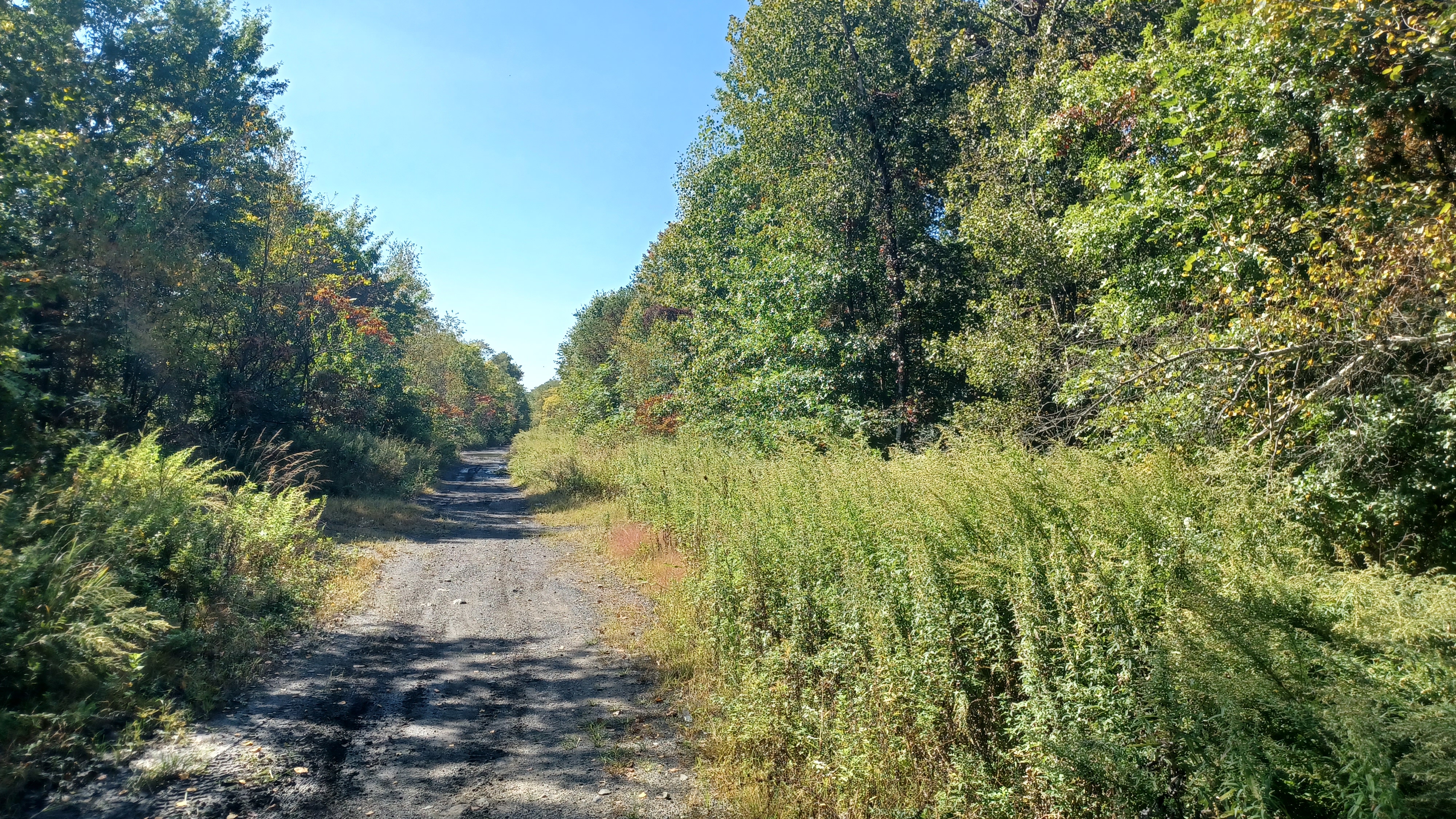
An ATV trail led into the woods, close to the railroad beds, but not right on the old Bloomsburg Branch just yet. That must be overgrown just below where we ended up.

Heading through the woods, it was a bit unnerving, because they are full of homeless people. One doesn't really associate an area so rural, just outside of Kingston, being something like that, but it is. We didn't engage directly with any of them, except one I think walked by us. Most of their tents were in areas just below us to the left.
The route we were following at first, I understand, was originally a rail branch into the coal industry, but was later used as a through road. It still had concrete pavement on it.

We pushed on through, past a couple of barricades, and the slabs were quite evident. At some point, the ATV path began to shift around a but until it came to a large open area, where I understand the breaker buildings used to be.

We had to shift to the left a little bit, and it started to become obvious where we got on the old railroad bed's main trackage bed. We continued ahead a bit more, and soon reached the underpass below Rt 11.
I was sure of the track bed when we saw that ties were still in place, although they were not at all noticeable except for where the ATV tracks went across them.
The underpass looks to me like it might have been placed after the abandonment of the railroad. The right of way had a little ballast on it, but overall was easier walking. Ev stood up in the stroller in his sort of "Tank Commander" way, as we approached the underpass.

Much of the right of way farther west from where we would be on it this day is now the Susquehanna Warrior Trail, and word is it will be extended to connect with the Luzerne Levee Trail system, so the bridge was probably built for that.

On the other side of the bridge, it was a mess of brush and invasives, a lot of phragmites and such, growing along the right of way. It was still pretty easy to push the stroller through overall though.

We were soon on a shelf above the Susquehanna, in a really nice area. The path was kept open enough by ATVs, but we didn't pass any in this area, so it was quiet and pleasant. It reminded me much of the rights of way my friends and I followed in the years when I started the group, so I felt really happy walking ahead of the others.
Pretty soon, we came upon a really cool discovery, an abandoned building on the left side of the track bed.
This was reportedly a coal industry pumping station, in the area of Larkville. I had been told it was associated with the Lance Colliery, which is farther west, but also that it was associated with the one we had just previously walked through. I'm more inclined to believe that based on the distance between the two.

It had a concrete sub level, and brick upper level. There was evidence of some attempt to demolish some of it, or rather, extract the components. It was more than a two story structure, with a set of concrete steps leading from around the outside down to the base of the building. John stayed with Ev while I went down to the bottom with Justin.
The one was entirely blasted out, I presume because the pumping system was probably taken out for scrap at some point following the closure of the industry.
We spent some time looking around this unexpected find, and then continued on the railroad bed heading to the west.
There were some splendid views to the left as we continued on, across the river. At one point, there was a view of where the former Plymouth Branch of the Delaware and Hudson Railroad once crossed the river.
The footway was rough at times, and there were some whoops up and down I had to take the stroller over, but it was far easier than a lot of the stuff we'd done previously.

There were yellow posts and such, because some sort of gas line and possibly other utilities were buried under the right of way. This is probably how they'll be able to put a trail in on it.


I didn't realize when we reached the spot where the D&H used to cross over the river. As per the Anthracite Railroads KMZ file I use for research on these hikes, this area was once the site of the Boston Breaker.


The right of way widened, and there was a wall along the inland side of both rights of way.

here are 1917 photos by Watson B. Bunnell, Lackawanna Railroad photographer, from the Steamtown National Historic Site archives, which show a tower that existed in this area.
The Delaware and Hudson would have crossed over the Lackawanna and headed further inland just ahead. When I realized I had missed the bridge site, I attempted to take some comparison photos of the site while the others caught up from far behind me.
In the wide former yard area, we started to come upon some seemingly abandoned vehicles parked along the way. As we continued along, these vehicles became more frequent.
It turns out that J L Used Auto Parts takes over the property of the right of way just ahead, and that some of that has encroached upon the rail beds to the east over the years. I was told by some locals when I later posted the photos that we were lucky, and that there is one of the homeless people living back there, paid off by the junk yard owner to throw people off of the property. We didn't see anyone, and we actually saw no signs as well.
The area ahead was home to the Lehigh and Wilkes Barre Coal Company, and then just beyond, the Lance Colliery.
When we got to the edge of the salvage yard, which takes over most of these industrial lands, we turned right on another ATV path that led away from the Lackawanna rail bed, on probably the D&H for a bit, then cut to the right into the back of A&B Tire and the access road to the old Shupp Cemetery, which was just above us to the right.


Several long trailers were parked on this access road, which we were able to walk right by with no problem, and get out to Rt 11, Boston Hill Road. There was an odd dragon with a lady riding its head on the business where we came out.


We crossed over to the left, and there was a convenience store and gas station just ahead. We went in to get some food and drinks, and I found some chocolate milk for Ev.
 |
| Watson Bunnel photo |

I think I might have grabbed a Four Loco as well. They had a lot of different liquor things, including I think adult slushies. This is a relatively new thing for Pennsylvania, especially on Sundays, but I'm not complaining.


We continued along 11 to the west for a bit, and there is now a Sheetz on part of where there was former industry, above the railroad bed. The D&H had crossed the road at the convenience store, and we had no way of getting back down to the Lackawanna just yet.

I think I went in to the Sheetz to give Ev a diaper change and to get rid of some garbage. From there, we made our way to Bridge Street, past the somewhat new Carey Avenue Bridge.
Bridge Street descended a bit, with some handsome old houses on a slope above us, and then crossed over the old Lackawanna track bed through a pony truss bridge. The road continued to Beade Street and ends, but this used to be where the road continued across the Breslau Bridge, a now long gone bridge over the Susquehanna.
The original Carey Avenue Bridge was built in 1894, and replaced by a steel girder bridge in 1948.
This spot has some interesting history, because when the 1948 span was put in, the Carey Avenue Bridge was moved further down the Susquehanna River to serve as a crossing for the State Correctional Retreat, a prison property, and was renamed the Retreat Bridge, and the 1948 span was torn down in favor of the new one in 2002.

When we do the next section to the west on this branch, we'll pass by the Retreat Bridge, one of the highlights I'm quite looking forward to.

I tried to put together a then and now of this site, using a photo that was wrongly referred to as the Carey Ave Bridge, when in fact it was the next one down, known as the Breslau Bridge.

We walked to the former bridge site, and the next bit of Luzerne Levee Trail begins there. Some of the old railroad bed was actually accessible in this area, through the neighborhoods, but I chose to skip that this time in favor of the easier trail with the stroller. That last bit had been a bit rough to get through at times, and one of the reasons for planning it this way was to give myself a bit of a break.
We took to a lower trail down along the waterfront at first so that I could have a look at the former bridge site, and I did manage to get one then and now compilation from here that was probably correct.
We continued along the trail, and soon made our way up to the levee area along the settlement of Plymouth. There were other coal industry rights of way that went through Plymouth, so maybe we'll go back there and walk those one day along with the Lackawanna grade through town.
While we walked there were some really interesting grated walkways, sort of platform structures to the left over areas of drainage below the levee system. Justin and Brittany climbed down one and went into a long pipe in it. I hate missing out on these things with the stroller, but fortunately Galya stayed with Ev, who was happily walking around on his own at this moment.
I climbed down and went into the pipe ahead, and they were back in there quite a ways. I only walked back for a bit. It probably would have gotten us stuck somewhere.

While I was in there, Ev apparently fell down while running around like crazy, right on the rubble rock walls of the levee. It wasn't so bad that he'd tumble down far, but it would be a concern. He's so tough, he wasn't even crying or anything when I came out. These types of things get me so worried. There are constantly threats along these trails, and part of me thinks I shouldn't even bring him in order to keep him safe, but of course I love having him there too much not to.


Ev had no cuts on him, so we were good to keep going along the trail.

There were constantly nice views of the town, and we passed the former site of the Breslau Bridge. This connected the settlement of Breslau in Hanover Township. It was a through truss type of structure built in 1911 and torn down in 2000. I didn't quite notice when we were in the area of it, or I would have tried to get some sort of then and now of the site.
We continued on the levee out in the open for a while, and both it and the trail turned ninety degrees to the north when we got to the Coal Creek.

The paved trail reached an intersection near Krest Street, where to the right it led to the road and some parking. To the left, the paved trail turned and abruptly stopped. This T intersection was the old Lackawanna line.


The pavement on the rail bed stopped just to the left, and there was a concrete barricade blocking the way. It was just barely wide enough on the right side to sneak the stroller through it.

There wasn't much shade on the right of way ahead, but it was totally clear and mostly good cinder dirt for walking. This clear area was apparently the former site of the Plymouth Washery Breaker.
When we reached an area with some bigger trees, we came to the former site of Auchincloss Junction. The Auchincloss Branch of the Lackawanna turned here to the south, crossed the Susquehanna River, and served the Loomis Breaker. We had hiked some of what maps showed as Auchincloss Branch briefly when we walked through the Concrete City on another hike.
This right of way is pretty overgrown, and the bridge that carried the line over the Susquehanna doesn't appear to have any remnants left.
We continued on the right of way west, and soon came really close to Rt 11. Lots of puddles were through the area, which I didn't mind walking through, and the stroller got through fine, but then we came to a really big one just before an access out to 11. I got through it, but then the path went off to the left, not in the direction I wanted to go. We needed to get back to another path further to the right. I thin the others bushwhacked the short bit over, but I had to walk back through the puddle to get the stroller through.
Along the Rt 11 access, we came upon the first official mention of a trail. Just ahead, was the former site of the Avondale Mine, and there was a sign reading "trail to mine memorial" or something to that effect.


The right of way was still a cinder path like before, but edges became nicely mowed on the way to the historic site of the Avondale Colliery. Soon, there were some ruins with steps that appeared to the right.

The Avondale Colliery dates back to 1863, and a coal breaker was erected over top of the mine in 1867, which was common practice of the time. From the rail bed the mouth of the mine was just above the first building foundations to the left.
Small fires were built at the bottoms of shafts to permit air circulation. On September 6th, 1869, this practice led to fire burning support timbers and spreading to the breaker itself, which blocked the only exit. 108 men and boys who were working the mine died of asphyxiation, as did 2 more men attempting to rescue.
The mine went back into service and a new breaker constructed. Mining continued at the site until the late 1960s.
This area was the most manicured we had been on other than the levee trail stuff so far. Weeds had been removed from much of the ruins. A remnant of rails was still in place between some concrete bases, and there was a good history kiosk telling the entire story of the mining industry there, complete with some great old photos.
Ev was tired from his adventuring on the levee, and he passed out just before we arrived at Avondale. I left him in a shady spot in the stroller, and we all had a break to look around the site.
Just above, the mouth of the mine, with the cold air coming out, was plainly visible and blocked by a metal grate.


Looking inside, we could see stone piers that were holding the roof of the mine.

Ev eventually hollered and cried, and I rushed over to take him out of the stroller. I was rather glad his nap was short this time, so that he could see the old mine.
Ev was really interested in the look of the old mine. Just down below, there was a set of railroad ties still in place, unearthed, and a railroad crossing sign installed next to it. Another kiosk with more historic photos was right next to it.
I tried to get as many then and now compilations as I could, but this site was pretty hard to tell just where everything was.
.jpg)


We continued onto the rail right of way to the west, and there were more concrete ruins ahead on our right. Somewhere in this area was the former site of the Chauncey Breaker, so some of it might have been that, but I'm not sure.

Pretty soon, we passed beneath the new Rt 11/Rt 29 bypass or connector. This is rather new I understand, but there were still bridges over the railroad bed. The southern swing of Rt 11 connects to the new Rt 29 bridge over the Susquehanna.
The right of way came close to the edge of older Rt 11 pretty soon, in the actually little coal patch settlement of Avondale. There were some old homes built into the slopes in this area.
To the left, there was a small building that had "WNAK", but we first thought it said "WANK". It was that much funnier that there was an adult club across the street. Some of the group wanted to go in, which would have been fun, but I couldn't do that with Ev, so we continued on.

Ahead, we crossed back beneath the newer Rt 11 and 29 connector again via a bridge. We checked out the river view on a side path of one of the two bridges, but I don't remember which one. I wanted to get in the water to cool off, and I might have found a spot here. I know I did at some point along the way, but it was probably back closer to Plymouth.


Pretty soon, we reached the little settlement of West Nanticoke, and passed beneath the old Nanticoke Bridge. There was a lot of old concrete and crap along the slope to the right, which must have been parts of old buildings. Included in the mess were some concrete stairs, so there might have been a building there at one time.


To the left, there was an old house along the right of way. At first, it looked as though it was probably abandoned, and then I realized that someone must still be living there. There just were not any cars around. It wasn't really in terrible shape, but it looked as though it was shifting along the slope of the river.

We continued ahead on the right of way, which at this point was sort of used as a driveway. We had to go this way to more easily get up to the slope of Rt 11, because the climb directly up at the bridge would have been a pain.
We made our way over to the Nanticoke Bridge, and began crossing.


I looked down when we reached the first bit of land on the other side, trying to see if I could find remnants of the old Pennsylvania Canal.

I tried to familiarize myself with the mapping a bit before we went on this hike, and although the canal used slack water navigation in the Susquehanna at this point, I understand that there was some sort of basin in from the river on the Nanticoke side.

The bridge was really long. Beyond the truss sections, the deck sections went on a long way.
When we finally reached the other side of the bridge, there were accesses to some industrial properties on both sides of the road, and the end of the abandoned railroad bridge.
In the past, I might have attempted to cross this bridge, which is in deplorable condition. At the very least, I might have taken one of the dirt construction roads nearer to it, or gotten along the active tracks of the former Pennsylvania Railroad line soon on the other side, which this abandoned bridge apparently connected to.

With the stroller, it changes a lot of things, and so this next bit got to be a bit more rough to do.

Pretty soon, at an intersection, there was a Weis Market, so we stopped for food and snacks and such there for a bit.
We left the store, and then headed to the east. We took Arch Street to Railroad Steet, and on the way walked through an abandoned car wash buildng.
The road was right above the railroad tracks for a time, which was nice, and the route wasn't too busy. We reached Main Street near the National Guard Amory, and then cut through a parking lot and grass to the left to come out to Loomis Street. This was also not terribly busy, and pleasant for walking.

We again paralleled the tracks until we reached where Main Street became the San Souci Parkway. This would be the biggest road we would walk along.

This was the crummiest portion of the hike really, but we made the best of it. Brittany put her bluetooth speaker on, playing a bunch of dance music. Ev stood up in the stroller doing his "tank commander" thing facing forward. While Brittany was dancing, Ev started emulating her, and it was absolutely hilarious.
We passed beneath Rt 29 bridge on the highway, and soon after that Dundee Road went to the right. There was a large abandoned coal industry building on the left side of that road, visible from where we were. I understand that is part of the former Loomis Breaker.

We had a narrower section of highway ahead, just after the last of the businesses on the road. In this area, a woods road to the left I think might have been more of the Lackawanna Railroad's Auchincloss Branch heading for the Loomis Breaker.

We got through this horribly narrow bit of the highway, and then turned left on Lincoln Drive, which took us rather steeply uphill for a bit.

We reached Main Road, and just across that and to the right of the intersection was the west side of the historic Hanover Green Cemetery of Hanover Twp Pa.
This cemetery was established June 9, 1776, barely predating American independence. This makes Hanover Green the oldest cemetery in the Wilkes-Barre area, with the exception of a few small private family plots.
We followed the edge of the cemetery to the north, and I had sort of considered trying to bushwhack from the end of it to the north, through woods toward the tracks along the Susquehanna below.

As we continued further into the cemetery, it became apparent that this was two separate cemeteries, with a large enough fence in between to deter us. We turned to the right to continue through the Hanover Green to the east instead of further to the north.
Had I been able to get through to the tracks, we might have tried to cross the Solomon Creek and gotten to the very western end of the south side Luzerne Levee Trail, but this didn't work out.

The other consideration was that Red Sean had contacted me about joining up with us late. If we got down into those woods, there was no easy way he was going to be able to meet with us.

We continued through the cemetery parallel with Church Street, but there was no access out! We reached the east side, at Center Street, and had to continue downhill to the right along the fence. When the fence came to an end, we went around it, and then followed Center Street back to the north again.
There might have been another way of accessing to the creek to the north, but at this point it was getting later, and I didn't want ot have any extra drama. We had already seen a lot on this trip, and I couldn't afford taking any extra out and back trips if I wanted to get done before dark.

Sean found a spot to park on the street in this area, and together we all continued to the north and east, then on Steele Street.

We followed this to Downing Street, and then passed through land of Hanover Korn Krest Green Elementary School. The other nearby coal patch settlement just to the south is indeed called Korn Crest. I have no idea how that settlement got its name, but I know the area around it used to be an amusement park called Hanover Park until the 70s.
My original intent, if not on the tracks or North Branch Canal, was to follow more side roads through this area, but again we were going pretty far, and had a ways to go. Instead, we just followed Main Road to the east again for a while.

This was an entertaining section because again, Brittany put on her speaker and played some children's songs. Standouts I remember being "Pirates Who Don't Do Anything" and "Baby Shark". This might have been Ev's first time hearing the latter, and he would go on to being crazy about the song like so many kids are.

We reached a peak of land and headed downhill, then turned left on Breaker Road. This is apparently named for the Buttonwood Shaft Breaker, which was abandoned before 1884.

A little ways on, we crossed over the Solomon Creek, and just on the south side of the crossing was once a former Central Railroad of New Jersey track, which served the Buttonwood Shaft Breaker.
There was an open industrial area, and then we crossed the former Pennsylvania Railroad, still active. This area was the western end of the former Buttonwood Yard.
We turned right after the tracks on Ferry Road, and then soon left on Nanticoke Street into a small neighborhood. We then turned to the left on 1st Street.

We were just starting to get burned out on the road walking I think. It was still rather hot out, and there had been far too much pavement. We soon turned left on Fellows Ave. This was the road that once led out to and crossed over the Breslau Bridge, which we passed on the way before.

We came to where the road was cut off to traffic, went around the barricades, and continued on the abandonment. This felt like a relief to me, to be out in a pedestrian only area, and with hardly anyone else around. There was a sewage treatement plant on the left, but other than that, it was pleasant.
Soon, we were out to the levee trail again, and we turned to the right to follow it. There was only about one more mile to the west of us on it that we had missed, which isn't so bad. I'd still like to get out that way, because there was once a lock on the canal in that area and I want to know if anything is left of it.

The levee trail took us above the river with some splendid views, above Richard Island, and along the edge of the settlement of Lynnwood.
We dipped down to go beneath the newer Carey Avenue Bridge, and back up to the top of the levee again. Ev got out of the stroller and walked for quite a while again in this section, which was pretty good. Along the way, Brittany got her speaker going again, and she and Red Sean were dancing with him, spinning him around, and he was just having a blast. I pushed the stroller behind them, entertained by the whole thing.

After seeing the end of Richard Island on the river, just ahead there was an access trail down the levee to the right. Where that hits the road was the former site of the Plymouth Branch of the Delaware and Hudson Railroad. The junction with the Wilkes Barre Connecting Railroad to the right was called Fish Junction. There was really no recognizable remains of this line today.

We continued around the bend of the river on the trail, and soon came to the Wilkes-Barre Connecting Railroad bridge over the Susquehanna, known as the Fish Island Bridge. We walked beneath it, and there were outstanding views up and down the Susquehanna from here as the sun was starting to set.

At this point, there wasn't a whole lot more left to the hike, but crossing this bridge would be slightly quicker. Of course, I could not take Ev across that with the stroller, but Justin and Brittany went across that way.
The bridge looked amazing with the lighting at this time.
Unfortunately, the trail did not continue right along the waterfront in this area. We had to head out to Riverside Drive, which had a good sidewalk through the area anyway.

We passed an historic marker to Teedyuscung, the aboriginal man who was looked upon as "King of the Delawares". He upheld the dignity of native people and strove to protect their rights to land in Pennsylvania. From 1756 to 1762, he represented his people in conferences in Easton.
Teedyuscung set up the last settlement of his people in this area in 1754. His cabin was close to where we were walking, and he died when it burned down in 1763.
We continued along the road to the intersection with River Street. We turned left there, and in about a block had access back up to the top of the flood protection berm.

A view to the Market Street Bridge between Wilkes-Barre and Kingston was prominent once we reached the top.
The 1,274 foot, 12 arch bridge, with the central 6 attractive open spandrel, was built 1926-29.
The four triumphal arches with limestone eagles partially spreading their wings were places as a memorial to veterans of World War I.

The sun was going down beautifully on the river, and we crossed Market Street Bridge at the perfect time to take in the views. By the time we reached the other side, it was getting dark, and the light poles on the paved pathways into Kirby Park were going on.
We made the left turn and headed into the park with the last remaining bit of daylight.
I knew we had done more miles than I had anticipated we would do, but I was incredibly happy to get this section out of the way. It actually felt like two different days to me overall; the first parton the levee and the railroad bed, and the second part on back roads and more levee.
I think in the future, the next bit of this right of way I want to explore is the section to the east from Kingston rather than to the west. To the west, it'll of course be all trail, and I'm looking forward to doing that section, but I would like to cover all of the branch from the east terminus first, I think.
It will also be sensible to do that section to the south during warmer weather, since we will be along the water most the entire day. There's a lot of great stuff to be excited about coming up.