Hike #1548; 5/10/23 Easton Area Loop with Kenny Zaruni and EverenThis next one would be another Easton area loop, almost the same as the one a couple of hikes prior, looping around Easton PA area, but with a little bit of a different start.
I got in touch with Ken, and planned on parking and meeting him in Easton, but I would be parking in Phillipsburg on North Main Street over past the Intervase Brewery.
I had a flat tire again in Ev's stroller, the second time it happened. I think it must have been from going through either thorns or the mess of garbage on the old Newtown Branch of the Reading Railroad on the previous hike.
The first time I had a flat tire, I went over to Easton, to Trek Bicycle, and they had me going again in like a half an hour, and for only about twenty bucks.
I've pushed the stroller on empty tires before, but I prefer not to do so of course. I started off that way, and put Ev in the seat. We made our way over toward the Bushkill Street Bridge, better known as the Rt 22 Bridge, and I had a then and now thing I wanted to get.
When the bridge opened in 1931 I think it was, the ramp on the New Jersey side came down much lower, and the original toll plaza was down there. Similarly, on the PA side, the road lined up to Bushkill Street. Both sides were changed after the Flood of '55, and it brought the grade of the highway up higher above the flood plain. That's why on the PA side, the road shifts abruptly when you get there from NJ, and on the NJ side, there is a grassy ramp adjacent to the highway, which was the old route.
The old administration building is still standing down below, with no toll houses. I went over there, and as best I could emulated the original postcard shot.
Ken was down along South Main somewhere, and I think we walked out that way along the road to catch up with him rather than cross the bridge at Rt 22, then we headed along the waterfront north to get to the bike repair place. I let Ev out of the stroller to ram around for a bit. Ken waited outside for a bit, until the guy inside said that his dog, Scout, was welcome in.
It took less than a half an hour, and we were on our way.
We walked up the street and into the Easton Circle, where I had a few more then and now history shots I wanted to take.
I had one of them featuring the monument, and another that showed some of the infrastructure of the underground restroom facilities that used to be there. I'm not sure if recent renovations eliminated or destroyed those facilities, or if they are currently capped, but still exist somewhere underground there.
Easton was settled in 1739, and founded as a community in 1752.
Easton became so important that it was one of the first three cities to have the Declaration of Independence read aloud, and one of the first to have the American Flag flown.
The center of the circle, or "Centre Square" was once home to Easton's first court house. It was town down in 1861 and replaced by an iron fountain. The iron fountain was moved to Nevin Park when the Soldiers and Sailors Memorial was erected in the circle in 1900.
The center area was originally just a square, but the circular road delineation owes its existence to a spite fence placed by the the then borough of Easton after a dispute regarding the local fire department's occupation of a county owned building.
The location has gone through many changes over the years, including the addition of the fountain around the memorial in 1975, and the elimination of the subterranean restrooms that were used from 1922 to 1968.
The 1960s group, The Cyrkle, with the hits "Red Rubber Ball" and "Turn Down Day" were from Lafayette College, and supposedly take their name from the location.
Major renovation was undertaken in 2022, and the Circle or Centre Square, whichever shape you prefer to refer, was reopened with text from the Declaration of Independence etched into the rock, and small paths weave around in segments.
We continued walking from the circle, which is what I more commonly refer to it as, to the west toward the Rt 611 intersection and the bridge over the Lehigh River.
We made a stop along the way at the smoke shop on the left at 611 so I could buy some chocolate milk and some Arizona RX Energy iced tea, as well as some snacks.
I had two more photos I wanted to emulate at the edge of 611, looking across to Mt Ida, the major rock outcropping that has a cut through it for both the former Central Railroad of New Jersey and the Lehigh Valley Railroad. The Lehigh Canal also used a slack water navigation in the Lehigh River between the Outlet Lock and the dam at the confluence with the Delaware here.
I had a few great photos that were in a book I bought on the Lehigh Canal recently, and so I wanted to try to get some modern versions of that.
I got the shots, and we continued across the bridge to the south.
We had to walk 611 for a bit, under the Jersey Central line, and then cut to the left when a chain link fence ended and we could get down to the Lehigh Canal towpath along the river. We could then begin following that upstream and beneath the 611 bridge and Jersey Central bridge once again.
There's a great view upstream, to the Easton and Northern Bridge built in 1899, and then we headed into some woods cover for a bit.
Much of the rest of the hike from here was what we had done the previous time out. We walked through this section, which was the vicinity of where Lehigh Canal Locks 48 and 49 used to be.
Those last two locks were filled in when the Lehigh Valley Railroad expanded in the area, and were replaced by the unnumbered Outlet Lock, which is the only fully concrete lock on the entire canal.
Some of the wickets from the original locks were saved and utilized in the drop gate of the newer lock, and so I had a closer look at them before we continued on past that lock.
The old vault building is still a mess there, and Lock 47 is just beyond and under the Easton and Northern Railroad bridge. We continued up beyond there, and then stayed along the canal towpath heading to the east. This was a good choice because a train soon went by on the former Lehigh Valley Railroad on the other side, and Ev loved it.
This was an oddball train because it was a work train with a back hoe precariously parked on the back of it with no visible restraint.
We continued on through to Hugh Moore Park, took the paved D&L Trail down and past the bike course, then turned right to cross the old Glendon Bridge. We then took the switchback up to get on the former Central Railroad of New Jersey, now paved.
It was a pleasant walk west from there, through the Riverside Park, where I stopped to give Ev a diaper change, and then on to the Chain Dam. We paused at that spot and looked over the current dam, which replaced the original one that had been upstream. The lock house on the Lehigh Canal in Hugh Moore Park was well visible and a train was going by on the former Lehigh Valley Railroad.
I made another of my little history videos, and I let Ev out of the stroller to walk for a while, which made it a little bit slower, but he was quite happy.
We continued on toward Freemansburg, but cut to the right before then on the former CNJ branch that used to go up to connect with the Easton and Northern line.
We passed under the Rt 33 bridge, skirted Hope Lock Road just above to the east, and then weaved back to cross under 33 once more. There were some nice field views on the rail bed in the section, then we crossed over Freemansburg Ave on the former rail bridge and continued into the suburban Wilson area stuff that started taking us back to Easton.
We continued pretty quickly; Ev fell asleep soon after I put him back in the stroller, and we moved along at a pretty good pace for a while.
After the area of Milford Street, the trail leaves the railroad bed and is a sort of parallel thing that I think was probably an industrial spur. There is a tall stack on that property, but I'm not sure what kind of industry it once served.
We dip down very steeply to the former Easton and Northern from there.
We got to that, then followed it to the north out to William Penn Highway, crossed, turned left, and continued on the paved trail that parallels the rail bed, which the Walgreens is built over.
I have a very similar shot by Rich Pace there taken back in February of 2002, the first time I walked through on the Easton and Northern line. It is so much different now, with an old white building now demolished, and the Walgreens in its place.
We continued across 25th Street, up where the bridge there used to be, and then out in back of the Taco Bell and Wendy's. I think I stopped and got some food at one of those places, but I can't quite recall which one we went for.
Where we turned off of the rail bed into the parking areas, there was an old truck parking area adjacent to the former Dixie Cup Factory, and someone was putting a lot of work into a new skate park there. I found out later that it was one that had not been officially approved of, so the work may be for nothing, but much respect to them for at least trying.
They were not exactly being quiet about it, as the one guy we saw working out there had music blaring away, a stone's throw from the Taco Bell.
I understand now that the Dixie Cup Factory has some new plans as well, which are quite different than the original plan of turning them into apartments similar to what was done with the nearby Simon Silk Mills.
The Dixie Cup plant here was opened in 1921, and it operated at this site until the 1980s when most all major operations moved to the Forks Industrial site north of Easton.
Now, even the Forks plant has closed up, in 2021 ending a century of production in the greater Lehigh Valley.
We got back on the rail grade and continued across Northampton Street, and in a short distance the trail turned left away from the railroad grade, then crosses Wood Avenue.
We continued on the trail into Lower Hackett Park, and then continued beyond where the trail turns up to cross Rt 22 into Upper Hackett Park. That trail eventually returns to the Easton and Northern line on the other side of Huntsman Pigments property which was just up ahead.
We continued parallel with Wood Avenue, through the park and ball fields, then out to the road where the former Easton and Northern line comes over close to it again.
We reached Hackett Ave, crossed, and continued up Wood Avenue parallel with the old pigment plant to our left.
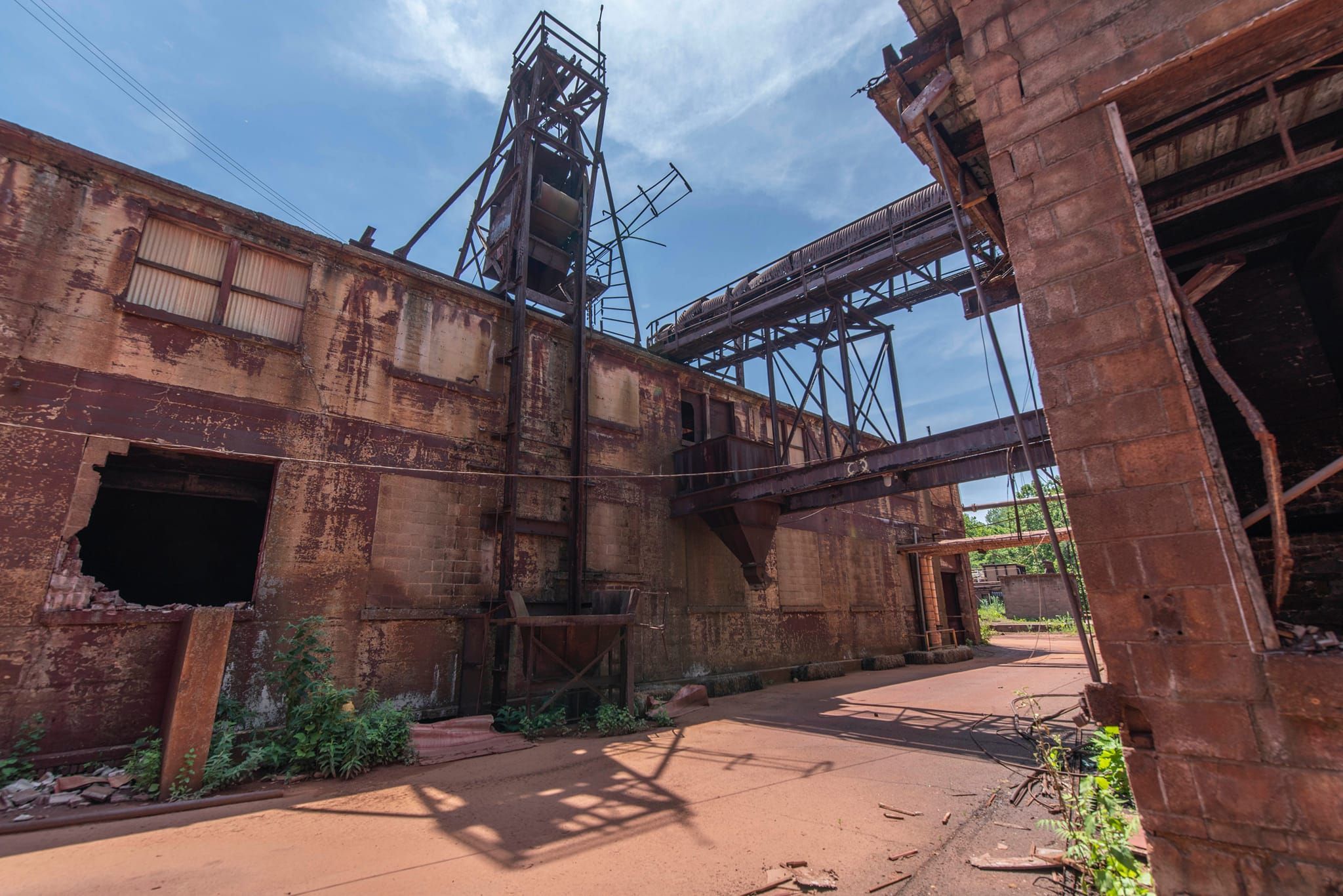
I had gotten into the plant on the previous trip out because it was just wide open a little further up. Since I had been in there and had taken several photos, Chuck Nyce on facebook sent me more photos he had taken of the Harcrose/Huntsman Pigments buildings before they had gotten demolished. I had at least one of them I needed to try to emulate going into the site this time.
We made our way down the road I knew the older photo to have been taken from and got it.
 |
| Chuck Nyce photo |
The former Easton and Northern Railroad bed and a couple of old roads go into the former Harcros Pigment Plant property, previously Huntsman Pigments, which is now just an expanse of disturbed land.
The business was still going until about 2017, a behemoth of a site visible from Rt 22, with giant rusty metal stacks and framework commanding the view.
The site dated way back to the 1870s, when iron oxide production started there. Supposedly the first structures were built by C. K. Williams. Several different entities owned the pigment plan over the years, including Pfizer in the 1960s.
There were workers that lived on site in company homes, on a street that was known as Lucy Street just above, now all demolished as well.
The Easton and Northern Railroad, part of the Lehigh Valley Railroad system, was abandoned in 1986, and it began development as a trail in the early 2000s. At that time, the business was still very busy and they did not want the trail going directly through.
Huntsman apparently funded the construction of new trail up into Upper Hackett Park, from which new connection would be made through Lower Hackett Park to avoid the industrial site and bypass that rail bed section.
The future of the site is uncertain, but it looks as though there may be plans to daylight a tributary to the Bushkill Creek that flowed underground beneath the facility.
We took the main road on down to the site, then to the intersection adjacent to where the old Easton and Northern line used to pass through.
From there, we turned to the right, and then made another right turn onto what used to be yet another right of way of a branch line that terminated along the downstream along the Bushkill Creek. We had to go under a couple of tree branches and such, but were out of there in no time. The route brought us out at the old coal chutes along Bushkill Creek adjacent to 13th Street.
At 13th, the Karl Stirner Arts Trail begins along the old railroad bed and always has new displays out on it, so I am fond of walking it over and over again. The original mill building is adjacent to the parking lot there, and the big Simon Silk Mill is across, and now apartments and businesses.
The mill was first opened in 1883 by Herman Simon with 250 employees. By 1900, the business had grown to 1,200 employees operating 1,500 pieces of machinery. By the 1920s, the silk industry ballooned in Pennsylvania to the point that one in three American silk workers were from Pennsylvania.
Despite
great success, these industries could not compete with the foreign synthetic materials trade, and the Simon Silk Mill closed in the 1960s.
After years of neglect and deterioration, it was proposed that the entire complex would be leveled in favor of ball fields and a new arts building, but the plan never materialized.
By 2010, new ideas for creative repurpose of the strong brick structures began to gain momentum, and the old mills have been redeveloped into upscale apartments with businesses on lower floors including restaurants, brewery, winery, galleries, and more.
The Simon Silk Mill is a bright example of how to reuse historic and sustainable infrastructure, rather than acquiesce to the typical developer looking for a clean slate.
We continued on down the trail, but took the side trail to the left to have a closer look at the old Easton and Northern bridge over the Bushkill Creek. The wood chip trail just goes down from the paved trail and comes back up. This bit of the Easton and Northern Railroad was not included in the trail when it was built, but apparently there are plans to add it on in the near future.
We continued along to the Easton Cemetery, then weaved out to the Bushkill Drive section where the new stairs are to be installed. As we got closer to the Rt 22 bridge, Ken headed off toward his car again, which was in downtown Phillipsburg somewhere, and I headed back with Ev across I think it was the Rt 22 bridge to get back to our car and closed out the day.
I really particularly enjoyed this one, as I got stuff done, documented stuff, finished early, had good company, and still got good exercise.


No comments:
Post a Comment