

Hike #1529; 2/5/23 Secaucus to North Bergen with Sam and Violet Chen, Professor John DiFiore, Serious Sean Dougherty, Jenny Tull, Michelle B, Teresa I, Justin Gurbisz, Jennifer Berndt, Tina Chen, and Everen.
This next trip would be a point to point, the second in our Hackensack River series!

I wanted to try to knock out a lot of this before we really got into the hot weather again, because I have so much stuff coming up in the Hackensack River series.
I posted it so that if we had any snow, we could do the next one in the series, which would take us to the American Dream Mall, but we have been having probably the easiest Winter of my life. We barely have had any snow at all.

This made things work out perfectly, and this hike would be a really great one.

We met at the Wendy's in North Bergen, in a large shopping mall area where there's a Walmart and a bunch of other stuff. The area was a bit tough to find, because the roads are so crazy there. Unfortunately, Diane was not able to find us and missed this hike.
We waited a little late for Diane, because it's just not like her not to show up. When it was over a half an hour, we moved on.
We headed to the Hudson Memorial Hospital, where we had passed by on the previous hike in the Hackensack River series. This was the hospital where Jen was born, so it was a cool spot to start again.

There is a paved trail that goes along the berm, beside the Hackensack River on the west side of the hospital, so we headed from the lot on over to that and started walking.

We reached the far end of the hospital, turned right on the trail, and headed out toward the Meadowlands Parkway. For some reason, maybe a fifty foot section of the trail was blocked by a chain saying not to enter, and it looked like there was nothing wrong with the path at all. Still, we went down and around it, or at least I did because I couldn't easily push Ev in the stroller over that.
We turned left, and the paved path continued parallel with Meadowlands Parkway to the north. We did just as we had done on the last hike here, and then turned to the left parallel with the parking garage at the Osprey Cove Apartments, only this time we stayed at the lower level. Last time we went on top of it to take in the view from up there.
We continued to the north along the waterfront, and when we got to the far side of the garage, there was an opening in the blocked chain link fence I could push the stroller over.

We continued under and to the left, and then made our way out the other side of the place, to what looked like a couple of vacant hotel buildings. We worked our way around the north side, and then descended to Snipes Park by crossing over a foot bridge, the same as we'd done the last time. Everyone helped to lift the stroller up or down over whatever was needed when it got to be areas that weren't flat.
We headed to the north side of Snipes Park, on a paved path, then weaved back around to the south again on the same path, which had a second foot bridge out of Snipes Park.

We crossed, then turned left, skirted some apartments, and reached Meadowlands Parkway. In this area, we had turned away from the waterfront last time to make a beeline for the Kohls to the east where we were parked.

On that trip, I had considered going north further around the Secaucus Greenway, but considering how long that would take this time, it was certainly a good thing we didn't make that attempt.
The Channel 9 WWOR-TV station building was on the left. The last time, we had crawled beneath the gate to get out to the road through that. The station has been closed for a while, and it looks as though the lot is only being used to park contractor's equipment.
This location was reportedly used for filming a few talk shows back in the 90s and maybe the 80s too, but I'm not sure. The shift in the stations, from WWOR to UPN or whatever it was failed and the station moved to another location leaving this one abandoned.

I've heard that the site is going to be completely redeveloped, but I'm not sure into what.
We continued to the north and soon passed beneath the eastbound Route 3 bridge, which was a long span with a single through truss section.


We made our way into a parking lot and to the rear of the Red Roof Inn, along the Hackensack River again in the back. They had their own private boat launch back there.
We soon passed beneath the westbound Rt 3 bridge, and around another building closer to the river. The American Dream Mall came into view with its enormous ferris wheel in this area. We turned left along a road beside some apartments or townhouses, and soon reached the end of the Secaucus Greenway.

The trail went directly out to the waterfront and then turned to the left, north. This was an outstanding section, and the views were continuous.

We continued to the north along the water and apartments, and eventually came to where the old Paterson Plank Road used to cross the Hackensack River. I think originally it would have been a ferry, but in later years, it was the route of a trolley as well, which would have had a bridge.
Trolley Park used to have trolley tracks still stretching to near the river, and Violet actually had photos of it before they were removed, which was somewhat recently. Not only did the end of the road have the trolley tracks, there was also an original section of cobblestone street.
It is sickening that they allowed this landmark to be ripped up, which defined the area with historic character.
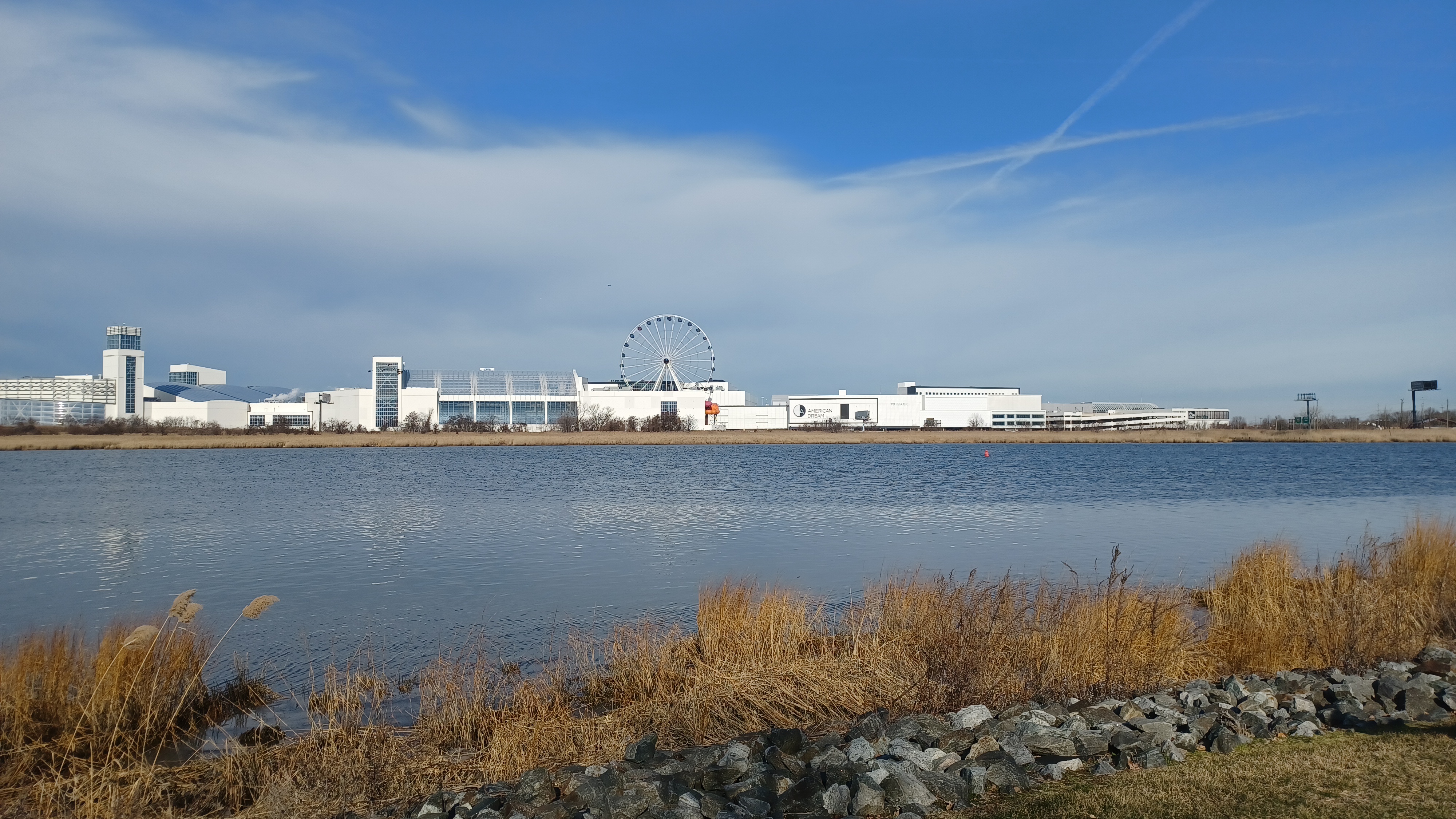
There were more great views of the American Dream Mall across the water from this area.

Well after the hike was over, Violet shared a photo of what the site looked like just last year, with the rails and cobblestone still in place.
I don't know what foolishness they were thinking to remove all of that, but
We continued along to the north and east a bit, and it soon came out to a small parking area at the end of Oak Lane. The trail doesn't continue on through to the east at this point because of private homes, so we had to go down Oak Lane, and then turne left on Acorn Road.
 |
| Trolley Park photo by Violet |
They took us to a house that was adorned with fine cut wood paneling as well as a hand-crafted, working water wheel. Sam and Violet had talked to the owner their last time out and said he was really cool. We didn't see him this time, but it was a cool thing to see.
We headed back to Acorn Road and continued to the east for a little bit, then turned left on Farm Road. This led us out ot Acorn Park, and we went to the left to remain on the outside of it. There was a sort of berm on the waterfront side of it, with a crushed stone trail on top of it, the next part of the Secaucus Greenway.
We continued along with great views of the Hackensack River where it bent to the east. There were several interpretive signs in place along the way that detailed the animal and plant life in the area.
The trail skirted the waterfront side of the Secaucus High School property, and at the end of that, got on an awesome, long boardwalk over the Mill Creek wetlands.
There are tidal wetlands through this area associated with the Mill Creek, and the boardwalk section leads out over them to a peninsula of higher land known as Mill Creek Point.

This was just a stunning area, and one of the best parts of the hike. Certainly people don't travel far to see this place, but it really was quite incredible.

Stupid destruction of history
We made our way across and out to Mill Creek Point. The Secaucus Greenway continued to the right, away from the views of the waterfront, so we continued into the grass to the left.

As one of the typical silly things that happens on these hikes, the gimmick brought by Serious Sean this time was a life size cardboard cut out of Waldo, of the "Where's Waldo" books and art.
Waldo was created by Martin Handford in Great Britain, with the first book published in 1987, featuring the character hidden in crowds and different settings throughout the world, and at different time periods. He is actually known as Wally, and the books are called "Where's Wally" in his home country, but for American and Canadian publication, they changed it to "Waldo".

Some say this was because in America, "Wally" is not seen as a typical name. I actually don't know the exact reason it was changed from Wally to Waldo.

Sean's idea was that he wanted to have Waldo show up in every photo throughout the hike, which of course was kind of impossible, but he definitely got him into a lot of them, and did his own great compilation of photos featuring him everywhere.
One of the funniest and best things about all of the silly antics is that it becomes so natural that we forget that we're even doing it.
While Sean was carrying the Waldo/Wally, he would forget that he's carrying a life size cut out of Waldo. I forget that I'm out hiking in a suit and tie. I forget that it's odd that I'm pushing a stroller through a rocky trail. Or that the group is dressed in a silly theme like bath robes or something.

When someone notices and reacts in some way, we forget that we're abnormal, and for a moment, have to question what it is about the onlooker(s) and how they are reacting to us.

There was a neat pavilion at the northernmost part of Mill Creek Point, so we went out to that and checked out the view.

To the right, there was a little Ampitheater area facing the water, which was pretty nice. We moved over to that, and could see the Hackensack River shifting between its east/west course to north/south again. The Mill Creek joins the river from the south to our right, and there was a fantastic view of the New York City skyline through the park. There was also a boat launch just slightly to the south.
We moved to the south slightly, and there was an old mill stone set in a large compass type of circle in the paver surface.

Around the outside, there was a set of blocks on guy who donated the mill stone, about a mastadon that had been found along the Hackensack, and about the native American name for the area.

As I understand, the mill stone was used in one of the old tide wheels, probably along the Mill Creek if it is significant to the area. These mills would have water wheels that worked with the tides. Some tides would come rushing in and out with such force that it could power a mill, and the wheel would work in both directions during the right times of day.
We continued from this area past the boat launch, and then onto the official route of the Secaucus Greenway, which skirted the west side of the park and then followed a berm parallel with Millridge Road.

I could have done a few things differently in the next section, which we didn't do, but as Sean said, it just meant we would have to come back to the area for another one.

There's definitely enough to justify more, and the Secaucus Greenway around the north point was well worth revisiting.
There is another informal path along the east side of the park and around ball fields we can do the next time, as well as one of the only remaining bits of natural woods in Hudson County that we missed this time, just to the south.
We continued to the end of the path, where the berm went right into private yards. We had to come down off of it at the official end of the greenway, and turned left into the Millridge Community Garden property.

We cut to the rear of the garden and then up onto another flood control berm. There, we turned to the right and followed the top of it out to the east side of some town houses.

We turned left along the back edge of these townhosues, and then had to turn right to get to Creekside Court. We walked through the development and emerged on Koelle Blvd. A brief left turn and another left into another parking lot took us past the Secaucus Recreation Center. We moved on around the left side of the building through grass, and soon reached a very nice statue of Mahatma Ghandi.
We continued around to the rear of the building, where there was a very nice paver circle and nice landscaping. The area is known as the Sadhu Vaswani Meditation Garden.

There was a good view of the wetlands from back there, as well as the New York City skyline once again.

We continued around the building and onto a sidewalk, back to the front, adjacent to a waste water treatment facility.
When I planned this hike, I had intended to cut across to Schmidt's Woods Park, which is that only woods area left in Hudson County but I missed it. We turned left on Koelle Blvd, and Sean pointed it out when we were just about past it.
I was a bit upset with myself for missing it because I was watching the aerial images so closely, but I concentrated too heavily on the waterfront, which is why I missed it.

We continued to Huber Street and turned left, and it looked like there might be a way of getting back on the waterfront on a flood control berm to come out at Monarch Park.

We reached the end of the road where there was a sign for Mill Creek Park, and a view through the reeds toward the city across the Mill Creek. It looked like the berm was doable from here.
Sean helped me to hoist Ev in the stroller over the wall at the end, and I carefully took the lead ahead on the berm, which wrapped around the backs of the houses along wetlands. Everything looked to be going alright, and it seemed that some people do walk it, but then I came to a fence at the end.
The chain link fence did come out to the Monarch Park, but it was too high to easily scale, especially with the stroller. For the amount of time and effort to get the group over, I decided it was better to just go back and make our way around.

As we went back, a guy came out of his house to holler at us from his second story deck.

"Hey, this isn't a walkin path!" he yelled. I told him that we just went in from the park and figured it was a through route, and that there were no signs saying otherwise. He immediately calmed down and we went by without a problem. He said that there wasn't a way through, changed his tune a bit and told us to be careful because if we fell to off, we'd be going down into the muck.
He certainly didn't know the kind of stuff we typically go through, and this was definitely not the kind of thing casual walkers do.

We made our way back the way we came and Sean helped me to hoist Ev back over the wall. We then headed back to Huber Ave.

From here, we followed the road to the west again, and continued until we got to Radio Ave. I was half wondering of the same guy would come back out of his house in the front ot see if we went by.
We continued left on Radio Ave to Monarch Park, where a little bit of the Secaucus Greenway exists for maybe a block. There were also some wooden platforms on the swamp around some serious radio towers that can be seen from miles away, all out in the wetland.
We continued through a vine covered archway, and then back to Radio Ave briefly, and then back to the left again onto another bit of greenway parallel with the road.

When the greenway came back out to the road again, we continued out toward Maple Street, and then turned left on a side road parking lot.

The parking lot had a sidewalk access out to Route 3 at the start of it, but then it was blocked off by thick shrubbery. I thought maybe we would be able to get through at the end near the next building, but there was no way. Tina was pushing Ev in the stroller, and there was no way of getting him through without having to ram on through or lift him over, so I told the others to go ahead, and I would hurry back to the last spot I could get out to 3, then come back on the sidewalk on the other side.
Everyone got pretty far ahead of me, but they waited over near a hotel building on the left.

Once we got past the Mill Creek, there was a Buy Rite liquor store and a Kohls, so we turned to the left and then walked out behind the Kohls, parallel with the Mill Creek.

A few cars came through, but mostly it was a pretty pleasant walk along the back of the place.
We paused at a spot where the grass came out in the parking lot because Ev was getting really fussy and I figured he needed another diaper change. I got him all cleaned up, and we moved on ahead to the north.
We passed behind The Mall at Mill Creek which included Ashley Furniture, Best Buy, Bob's Discount Furniture, and Burlington Coat Factory, and at the northern end of the lot, reached the entrance to the Mill Creek Marsh Trail.

This would be one of the most beautiful sections of the entire hike.

The Mill Creek Marsh was incredibly beautiful, and it is set up in such a way that we can walk in one way and out the other without doubling back on the same ground.
We went through the main entrance, which was oddly lined with quarry stone, and led us to the east, to where there was a fork in the path. We of course took the longer way, which was the left fork. Ev was in a very good mood having a clean diaper, and he soon fell asleep on the nice flat terrain.
There were some great views across the wetlands toward the New York City skyline again, and through these wetlands were the old stumps of Atlantic White Cedars, probably cut down a century ago or more.

A side path led to the left, out to a little lollipop loop, which we took and doubled back, and it allowed those in the back of the group the time to catch up with the rest of us.

A second side path to the left led to another wooden platform with no purpose to it. We continued back to the main path to the east side of the trail, and then turned to the south.
There were great views of the main flow of the Mill Creek to our right through this section.
Sean brought some Old Stock Ale from Northwest Brewing that was pretty good, and we sampled that out there. We continued to the south, and there was a section with more trees, followed by an area of more prominent Atlantic White Cedar stumps, and the tidal water going out over them. Just past that, there was another long section of boardwalk over a section of wetland.

We eventually came to the trail intersection that would close a full loop, but we went straight across on a wooden foot bridge.

It led to a chain link fence area, which we went around, and then skirted and passed beneath the Park Plaza Drive bridge.
We turned right behind the Michael's and Pet Smart stores, and pretty soon we came to a little foot path that steeply went up to the Park Plaza Drive. I flipped Ev's stroller around backwards and pulled him up the hill on the slope, then we lifted him over railing at the top onto the sidewalk on the road.
There was a good sidewalk on Park Plaza Drive over the Mill Creek, and once we were on the other side, we turned to the left into the Sam's Club and Walmart parking areas.

We followed the sidewalk for a bit out to the buildings, and we we reached the end of the Sam's Club, we cut to the right, directly across the parking area.

At the other end of the parking lot was the Harper at Harmon Meadow Apartments. There was a chain link fence that blocked people from the Walmart from getting over to the apartments, or to the next bit of greenway trail on the wetlands.
It was kind of annoying, and Jen pulled a shopping cart up to the edge, flipped it on its side, and used it to get over the fence, which was about four or four and a half feet high. We lifted Ev right across with the stroller.
Immediatly on the other side, a paved section of greenway headed to the north again. They obviously didn't want any of the Walmart patrons to have any access to this trail or there would have been a break in the fence. I would assume the people from the apartments didn't want them out there.

It was an interesting character study, watching the people. The people going to the Sam's Club were dressed better, their cars were more expensive, and just looked to have higher incomes, whereas the patrons to the Walmart were more wearing ratty sweat pants, and drove more beat up cars.

We continued on the path to the north, turned ninety degrees to the right, reached the edge of the Cromakill Creek, and then turned to the right, back to the south again. Tina pushed Ev again, who had woken up pretty well, and was hanging around the stroller looking ahead.
After that first ninety degree bend, the trail was one of the coolest parcourse circuits I'd ever seen. There were all sorts of exercise fitness stations along the trail, but they were not wuss ones. These had things like monkey bars and more strength test types of things we don't typically see on these courses.

There was a pole climbing thing, and there were some nice monkey bars. I went across them a couple of times, skipping every other rung and swinging like a monkey.

Sean was really going at it with these things, and took just about any challenge we had the time for, which is always fun.
Pretty soon, we reached a big parking lot and turned to the left, and then right to continue to the south. This was a busy area. The side road merged with Park Plaza Drive again, and we continued to the south parallel with some businesses and such in this development.
The group was beginning to ask me when we were going to stop to eat, and I'd looked ahead at Google maps a bit.

Maybe we should have stopped in this area because we wouldn't come across quite a lot before we got to the end point, but I'm glad we waited a bit of time anyway.

We continued south to the Paterson Plank Road again, and turned to the left, heading east.
We continued to a bridge over railroad tracks, which I think used to be part of the West Shore Railroad. There was a little path going down to the left, which led to West Side Ave, and that had been my intended route, but that kind of changed at this point because it looked a little boring, and it wouldn't get us to where there was any food.
By missing this section, we only missed one little bit of greenway trail, a small foot bridge, and less than a quarter mile of path that might be indefinitely closed off anyway along the edges of some industries. It looked covered over by dirt in some of the google street views.

Historically, the maps showed this area on the other side of the bridge as called Schuetzen Park. Newer maps refer to this as New Durham.

As we crossed the bridge, a building to the left had a chicken with a talk bubble reading "Pat LaFrieda says eat my meat", and another sign below it that read "reliable". For some reason I found this hilarious.
Once we were across the bridge, we turned to the left and took a side road that descended to Routes 1 and 9, Tonnele Avenue. At this point, we were getting closer to the end very fast and we needed to decide on somewhere to eat.
I didn't want to make the decision, so I had everyone looking at their phones to determine where we would go. Some of the suggestions were up and over the Palisade formation and way out of the way.

I didn't mind much, but I knew not the entire group would want to do all of that.

We continued north on the road, headed right over to Bergen Turnpike for a bit, and then made our way to Rumba Cubana to see about having some late lunch there.
The place looked very nice, and there was one of the most beautiful baby blue Chevy Belairs I have ever seen parked under a car port.
The place had more than a half an hour wait to get in, so we all decided to move on ahead. Some of the group decided to break off and get back to their cars anyway, but most of us continued. This was the area that even today is known as New Durham.

We continued ahead, and we reached the crossing of the Hudson Bergen Light Rail and Tonnelle Ave Station. I think this used to be New York Central Railroad at one time, but I don't remember.

There is a tunnel beneath the Palisades formation that the light rail uses today.
We continued to the north, and to the west of us was the Granton New Durham Rail Yards, which are still quite active. The light rail no longer connects with it, but rather has a loop at where the connection used to be.
The walk to the north took us through more neighborhood, and then parallel with the Hoboken Cemetery, as well as the Macphelah Cemetery.

I would like to walk through both of these because it seems that both of them would provide for excellent views to the west.

We already had some views to the west along the small slope the road was on, and at times we could see toward the Watchung Mountains further west.
After being let down a bit from the previous Spanish food type of place, we had our eyes set on Noches de Colombia ahead. I waited outside for a bit to see what some of the group through going in.
At first, I thought we weren't going to be going in, because I was told it was crowded, there wouldn't be much room for a stroller, and that there was loud music playing. A couple other opinions were thrown around, and it didn't seem too terribly loud, so I agreed to go on in.

I took an end spot at a table where I was able to pull Ev's stroller right up rather than use a regular elevated seat.

We ordered some pretty good food. I forget what it was that I had, but I enjoyed it, and Ev had a good amount of it, so he was content.
I made sure it would be something with mushrooms and vegetables and such that he would be able to eat.
I think someone had fries or something with theirs as well, so he got to have some of that too.
The entertainment in this venue was a Spanish singer in a beige coat with black trim, sporting a goatee that was longer than the short trimmed beard on the rest of his face.

He was just using a computer and a karaoke machine as backup, and there was a projector on the wall that showed a continuous loop of head shots and his name: D'Marquez.

He was a pretty great singer, and did sang some slow songs wonderfully, all in Spanish. His head shots didn't really do him justice because his hair looked super thinning in them, but wasn't that bad in real life. It was just kind of funny that it was a guy with a karaoke machine as the regular entertainment.
I kept on repeating "El karaoke profesional". It felt kind of silly, but Teresa in particular loved him!
We spent a good amount of time in there, and Ev waved at other patrons to the place, who all thought he was cute.

He eventually crawled out of his stroller and ended up sitting in the middle of the table, getting whatever food like fries and such from everyone.

At this point, we were within a mile of where we were parked, and we had only done twelve or thirteen miles. We had missed the one park I wanted to get into earlier, and the one side trip, and I had figured we would make up the remainder of the time by wandering through stores and such.
The hike was pretty cool, but I wasn't going to cut it short under my 15 mile minumum, and I certainly wasn't going to try to cut it short because it was Jenny's last time she would be out with us before she would embark on the Appalachian Trail.

The only thing I had in mind for this was to do stores and such, but then Justin had a suggestion that would be the perfect coda to this hike.

We would continue a bit further north to Fairview, and check out the old Edgewater Tunnel. This was an abandoned railroad tunnel I had heard of so many times, but I had never been through it before.
It was one of the only railroad tunnels in the state I had never been through, which makes it a big deal.
This tunnel has a great history that ties into so much other stuff we had been doing for years.

It was part of the New York, Susquehanna, and Western Railroad, which I'd been following for much of my life, as about thirty miles of it are now the Paulinskill Valley Trail.

The line was completed between Jersey City and East Stroudsburg PA in 1881, but it required some trackage rights over the Delaware, Lackawanna, and Western Railroad to the east and west, and Pennsylvania Railroad to the east in order to get from coal country to the ports.
The western end of it was taken care of with a subsidiary known as the Wilkes Barre and Eastern, which I led a series of hikes on to completion. That was completed in 1893.

To the east, a similar subsidiary, the Hudson River Railroad and Terminal Company, took care of the job getting the railroad directly to the Hudson River. It was completed in 1894.

The Erie Railroad held a controlling interest in the NYS&W at the time.

The Edgewater Branch would end up being 3.174 miles long from the Little Ferry Yard in Ridgefield, east to Fairview, beneath Bergen Hill (part of the Palisades formation) and out to Undercliff, which was what Edgewater was known as at the time.

The line connected directly out to yards on the Hudson River and eliminated the need for the Lackwanna and Pennsylvania Railroads.

There were substantial operations including a car float on the Hudson at the time of completion. The shore line was dominated by industries that included Alcoa Aluminum, Lever Brothers, Ford Motor Company, Archer Daniels Midland, and Valvoline Oil.
All of those businesses slowly died off, and the Ford Motor Company's Assembly Plant closed in 1955.
The west end of the line also did not see success for so many years. It was a single track line, and even though it was the most direct route from coal mines to port, the many sharp curves on the line required that lower speed limits be imposed.

The Lackawanna double tracked and eliminated many sharp curves after 1900, and so the NYS&W couldn't really compete. The Wilkes Barre and Eastern was closed down in 1939, and much of the NYS&W was abandoned in 1962.

Still, the Edgewater Tunnel remained lightly used until about 1991, and the tracks were removed about 1992. A power cable as well as a pipeline were placed within the tunnel by 2013, but it has otherwise remained out of use. It was discussed for reactivation as part of the Hudson-Bergen Light Rail we passed a bit earlier,
The Edgewater Branch is still active just to about five hundred feet west of the west portal of the tunnel, but no longer passes through. The future of the tunnel itself remains in question as their is active costruction going on on the east side with some new hotel or something. The west side is in the middle of a cemetery, so there won't be anything developed there. It would be a really cool trail, but I doubt we'll see anything of that any time soon.


Justin had been through it before, so he knew how to get down there. I turned the hike over to him, and he led the way further up Routes 1 and 9 toward that.

We passed a store that was selling High Viz clothing and commented that Craig Fredon should be with us to see it (because he always wears high viz).
The huge Fairview Cemetery soon appeared on the right side. Edgewater Tunnel makes its way into Weird New Jersey a lot, not just because it's an abandoned tunnel, but because it goes directly under a cemetery. So, there are bodies directly above anyone going through it. That's certainly a strange feeling.
The cemetery may not have been started until after the railroad was completed, but I'm not sure.
We continued past the cemetery and crossed over the railroad bed along the right, east side of the highway. 
1954 by Walter Zullig

After a little bit, there was a road, now fenced off, that descended parallel with 1 and 9 to a self storage facility office, and apparently an apartment area that was crack houses or something, now gone.

There had been a rail siding that went into that facility, whatever it used to be. Today, the tracks end just parallel with it.
We crossed over the highway when there weren't cars coming, but it didn't look like there was a good way to get down the road, just because of the chain link fences. The concrete wall on the highway side had no sidewalk, and we'd have to time it for when there was no traffic to get over it there.
Sean seemed to think we could do it easily, and he was right. We hurried over when we saw no traffic, hoisted the stroller over, which was easier than a lot of the things we'd hoisted it over in the past, and then just casually started walking downhill. .png)
1985 by Ken Accomando

We were soon out of sight of the highway, and the active construction site was not active at all on a Sunday afternoon.

We reached the railroad bed to find no blockage whatsoever. We simply turned left on it and started into the rail cut.
A stream flowed to the right of us there, and had an odd sort of culvert beneath the 1 and 9 underpass that kept it from the railroad bed.
As we headed deeper into the cut, there was only maybe one down branch I had to lift the stroller over. Other than that, it was totally clear and pretty easy walking except for the ballast rock.
The tunnel was a sight to behold. It was amazing not to see anyone else down there considering how easy it was to reach.

The stream that flowed down cascaded over a small waterfall to the right from the cemetery. Water did flow into the tunnel to some degree, but it was shallow enough through most of it that we could just walk on through.

I pushed Ev inside in the stroller, and he wasn't in the least bit scared.
I was surprised to see that inside the tunnel, there was an elevated concrete walkway along the left side, and the right side had another concrete walkway that was pretty much flush with the level of the ballast rock where the rails had been.
I kept to the right because it was the easiest to do. There were a few collapsed spots, but it wasn't all that bad, and when those kinds of rocks were in the way, I just went around them back out toward the middle.
The tunnel is about a mile long, almost equal with the Musconetcong Tunnel in Pattenberg, but easier to get through because there's less water.
1980s by Ken Accomando

We could see the other side most of the way through, and it just got bigger as we continued.

About half way through, there is a shaft to the surface, which was created because of the steam locomotives and the inhalation risks caused by them during the days of steam. I suspect that if it were to be reactivated today, they'd have to run only electric through it in order to mitigate some of that.
Water was falling down from the hole, which looked really crazy being in the middle of this tunnel. At that point, I understand that we were 200 feet below the surface.
We continued through the tunnel, and as we got closer to the other side, the water on the tunnel floor began getting a bit deeper. I continued through it for a while, because it wouldn't get the stuff in the stroller wet just yet, but I wouldn't have long.

Eventually, I asked Sean to help me lift the stroller up onto the ledge on the left side of the tunnel so I could continue. This was pretty good overall, but I had to get down when there was a collapse blocking it and come back up.

Eventually, even the ledge along the left side reached the water. The water level at the entrance to the east end is so deep that there would be no getting through with the stroller at all. We were very close to it, and no one was working to cause a problem.
Still, we could see contractors equipment parked direclty outside of the tunnel mouth. That portal is even visible from roads, and can be seen on Google street view.
I didn't need to do that last hundred feet or so to feel happy with having gone through. We turned back, and I stayed on the ledge to the right for a while, and had Sean help me get back over the collapse area again. Most of the group I think made it most of the way through.

After a while, that ledge was getting to be too much a pain, so I lowered the stroller back down to the floor, then back over to the other concrete walkway on the other side because it had been easier.

We continued pretty quickly back to the other side of the tunnel, and I was incredibly happy to have done this, and still in shock that it was as easy to do as it was.
Ev absolutely loved it too, because he loves shouting out and hearing his echo. He did that until we were clear of the tunnel mouth.
The slow stroll back out found me taking photos of the tunnel mouth at different angles for potential use in then and now history compilations.
This would end up panning out well, because when I posted the photos, several more historic photos of the site were shared, and matched up pretty closely with what I had taken. A few of those compilations are presented in this journal.

We made our way back the way we came, and then turned back up the old road to the right to reach Rts 1 and 9 again. I once again had Sean help me get Ev over, and it was just as easy as before.

We waited for the traffic to die off, and then continued back to the south along the highway.
As we headed back, all I could do was thinking how thankful I am to have this life, where I haven't given up on my dreams and adventures at all. I've had to make concessions and shift trajectory a bit in order to accommodate my son, and he enriches rather than inhibits the adventure.
We headed back to the south and crossed over when we got to 91st Street. From there, it was just a little meandering through the parking lot and we were back ot the cars at the Wendy's.
By taking the side trip to the tunnel, it put us up over the fifteen miles I wanted to do, and it was the perfect way of closing out this great hike.


It was also a perfect adventure to close Jenny's last hike with us before heading out on the Appalachian Trail.


She wouldn't be able to join the hike the following week because her family was planning on having some gathering for her, which made this the last one. 
The tunnel shaft
She would take off on Monday February 13th, and start hiking the AT in Springer Mountain Georgia on Valentines Day.
Unlike so many of these hikes where I head home feeling exhausted and have to take a power nap, this one had me feeling energized. I was really incredibly happy having it work out the way it did.
Just looking at the map of the area we covered, with aerial images and all, one would never think that what we had just walked would be as enjoyable as it was, but it was really fantastic.
I can't wait to get back out and do the next bit of the Hackensack River, which will probably end up being along its tributary, the Overpeck Creek.
There are so many more great things coming up, and I'm beyond ecstatic about it.