

Hike #1555; 6/11/23 Scheafferstown to Brunnerville with Kirk Rohn, David Adams, Diane Reider, Brittany Weider, Mike Heaney, Ken ?, and Everen
This next hike would sort of fit into the next stuff I'd been doing in the Furnace Hills area, but also be the first one in my planned series to hike the Conestoga Trail again.

I had already hiked the entire Conestoga Trail before with Ev's mom, Jillane. I really loved it a lot. The first bit we did as part of a backpacking trip from the Horse-Shoe Trail south to Lancaster.
The second bit we did together was part of an overnight trip we did just on the Lancaster section. The last section we did was southbound on the Conestoga Trail, to the Mason-Dixon Trail, and then that south to Havre De Grace, Maryland.
The trail was so weird, it was one of my favorites we ever hiked. I was really excited to get to doing it again. There were some reroutes along the way, so it made it kind of worthwhile to do more.
I wasn't happy to do just the Conestoga Trail however. There is so much stuff through these areas I wanted to see, and I'm trying to incorporate everything along the way.

For this first section, I thought of how much I loved the creeks the Conestoga Trail followed (it follows Hammer Creek to Cocalico Creek to Conestoga River, then to Pequaea Creek, then the Susquehanna), but there's a lot more to the Hammer Creek.

I particularly loved that creek, so I decided that the hike would begin around the headwaters of the Hammer Creek, and we'd walk pleasant backroads south to the start of the Conestoga Trail. As such, it was more of a Hammer Creek themed hike than a Conestoga Trail hike.
How exactly to put this one together was a bit of a challenge for me, but I settled on how the series would go, or at least I thought I did, before even doing the first one (it would change).
Part of the challenge in these hikes is having adequate places to park at the beginning and ends of the hikes. For this one, I found a location that worked in the John Beck Elementary School in Brunnerville PA, a northern suburb of Lititz.

We all met there, and then shuttled to the north to begin the hike in Schaefferstown, which was north of the Furnace Hills. I chose a spot at the local fire department, in a lot adjacent to their baseball field off of Locust Street.

To start, we simply walked from the parking lot and down the hill onto Locust Street to begin heading south.
We crossed over Oak Street and then came to Rt 419, Main Street in Schaefferstown.
It is believed this settlement was founded before 1720 by a group of German Jews.
The town is named for Alexander Shaeffer, who settled here in 1758.
Schaeffer was the local tavern owner, a common way a settlement comes to be known for a proprietor.

We continued across Main Street on Locust Street onto the lovely dirt farm lane to the Alexander Schaeffer farmstead. It's a rather obscure little spot to go to, and doesn't immediately look like public are allowed to go back the lane.

There were lovely views from the driveway heading down, and then a handsome golden yellow barn to the right. Just ahead, the old homestead was at an intersection in the dirt lanes.
The original portion of the house was built in 1738, and it was apparently that smaller size when Schaeffer purchased it some twenty years later. Schaeffer build the addition to the house of similar native stone to the original section in 1771.
The German-Colonial style building is known as a "Weinbauernhaus", or wine maker's house. The ground level of the original house section has a lower level vault storage space for the distilling process.

Schaeffer probably purchased this property as an extension of his business as tavern owner in the town.

This was a really beautiful spot, and giant Sycamore and Silver Maple trees were found around the homestead, and along the other entrance road leading east out to Carpenter Street.
We meandered around the building, and saw a little of the headwaters of the Hammer Creek flowing down behind the house with a little bridge. They originate in the Schaeffertown Springs located a short distance away to the east, maybe four or five blocks worth.
We turned to the left, east, down the lane to Carenter Street, and we were afforded a pretty good view to the north of more of Scheaffertown.

When we got out to Carpenter, rather than walk the busier street to the south, I decided we would turn slightly left, and then right on Cherry Alley to Lancaster Avenue.

As we reached these intersections and looked to the north, we saw a stately old building on the corner.
This was the Weigley Mansion, also known as Heidelberg Hall, built 1876-1882.

The Second Empire style sandstone mansion with mansard roof was designed by Isaac H Hobbs for prominent businessman and philanthropist William M Weigley, one of the most influential men in Lebanon County in the latter half of the nineteenth century.
We continued down Cherry Alley to Lancaster Ave and turned to the right. This steet would be less busy than parallel Carpenter.
Pretty soon, we crossed over the tributary of the Hammer Creek only a couple of blocks from where this branch begins.

We headed uphill on the road, and Market Street came in on the left. We continued up to the top, and then turned right on Old Mill Road.

We soon crossed over Carpenter Street, which is a cul de sac dead end to the left. It looks as though this was once the main drag from the south into town, but it was cut off from Rt 501, Stiegel Pike. We continued ahead and crossed that busy road, and continued on Old Mill Road.
We made our way down the road, with excellent views to the left, of farmland and beyond to the Furnace Hills. We dipped down a bit, and in one of the brief segments of shade on the road, came to a Black Mulberry tree with ripe fruits.

I passed one of the berries to Ev, and he ate it up right away. He ended up eating a ton of them, and his hands and face were covered in purple stain for most of the rest of the day.

One of the few one syllable words he's producing is "YUM", and it's quite hilarious to hear him saying that and "Nomnomnom" as he excitedly eats the berries. He shovels them into his mouth so fast, it is quite adorable.

Black Mulberry or Morus nigra, along Old Mill Rd near Schaefferstown PA.
Black Mulberry is actually an introduced species, which has been around for so long that it is typically regarded as naturalized.
Native to southwest Asia, they are thought to have originated from the mountains of Mesopotamia and Persia.
The trees were cultivated and spread west, to England by the 1600s for the failed attempt of hosting silkworm.
The edible berries can range from dull to strong sweetness and have been used for a variety of jams and sherbets.

The Hammer Creek was immediately to the left of the road starting in this area. Some of its headwaters were in the Schaeffer farmstead to the north, and flowed over to it, but this main flow found its way out of fields in this area.

We had lovely views along the creek, two little bridges in the farm to the left, and signs denoting that this land had been preserved by the Lebanon County Agricultural Land Preservation Board.
We passed a beautiful huge bank barn ahead on the right, ascended a bit, and reached Distillery Road.
We turned left here, and crossed the Hammer Creek, with more good farmland views as well as views out to the Furnace Hills beyond. There was a beautiful old stone farmstead to the left at the bridge as well.


We descended a bit on the road to the old buildings, with the most historic one right next to the road.

This was the first industrial Distillery facility in America and was the oldest operating when it closed in 1989.
Production began on this site by 1753 by Swiss Mennonite farmers John and Michael Shenk. Abraham Bomberger purchased the property in 1860.
By the mid 1900s, Louis Forman owned the site, and along with Master distiller Charles Everett Beam, of the famous Kentucky whiskey producing family, they developed Michter's Original Sour Mash Whiskey. The name comes from an amalgamation of Forman's sons names, Michael and Pete.

Much of the facility was demolished, but the circa 1840 still house and some other structures remain.
A modern distillery in Louisville Kentucky uses the Michter's and Bomberger's names but have no relation to the original Pennsylvania outfit.

There was a spot where there used to be some sort of epitaph on the historic relevance of the property, but it had been removed, so there was no sign at this site talking about what this place was.

At the old distillery building, I felt it appropriate that we do a shot of whiskey, so I made sure to bring some on the hike.
It was rather disappointing to see how the place had fallen apart.
I can't say it wasn't well manicured at all, but it wasn't what it was. There was still a large parking lot, for when they would have been taking on many visitors, and the old distillery building was in fine shape, but there were obviously more buildings that had been in the area, which were now demolished.

There was also a giant whiskey jug that apparently once sat on top of one of the buildings, in view behind the distillery building.

We continued walking the road to the south, and we came close to the Hammer Creek once more.
The road turned somewhat at the distillery, and we could see the clearing in the Furnace Hills where some logging had been done somewhat recently.
We passed a couple more farms, and came to the intersection with Obie Road, where it crossed Hammer Creek, and we continued straight on Michters Road, which soon became unpaved.

The road became an unpaved gravel route, and very pleasant.

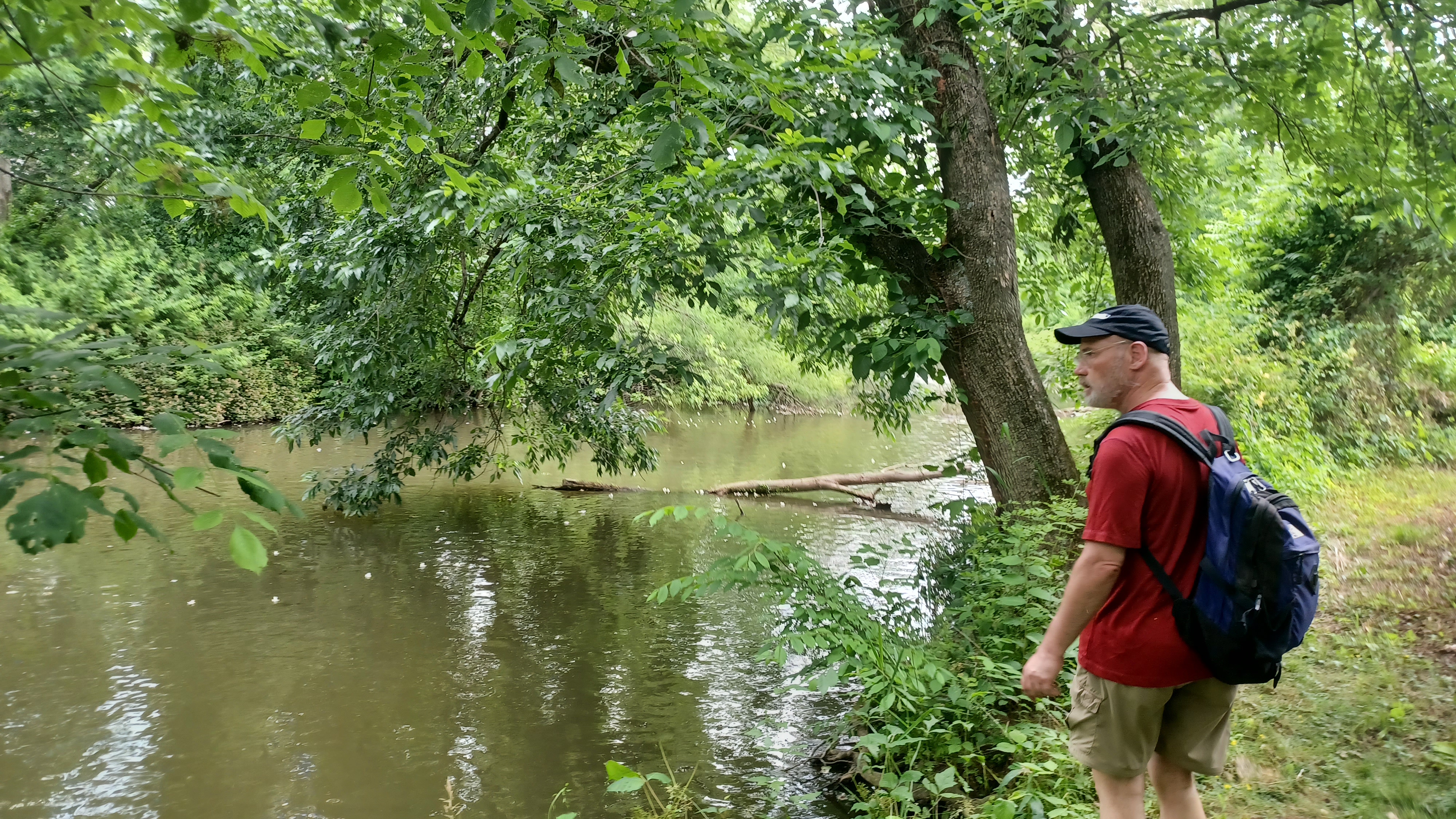
We made our way south for a while, on a shelf above the creek that was just lovely. I kept checking for paths down to the water on our left, so we could go in for a dip. It was getting really hot out and I wanted to get in badly.
We made our way down the road, at this point through State Game Lands 183.
After a while, I spotted a good path to a swim spot where we were able to go down and get in. It wasn't too deep, but it was enough that I could lay in it and saturate myself.

There were more people in this area, as we could hear their voices. I was glad we chose this spot, because anything better that was farther down would certainly have a lot of people already there.

After cooling off, we headed back up to the road and continued to the south a bit. To the left, I spotted some old masonry stuff along a small tributary or side stream, which might have been part of an old water works in the area.
At the Lebanon to Lancaster County line, I think is where the road name changed to Pumping Station Road, which is apparently named for this thing that used to be to the left. I really don't know any of the history behind that.

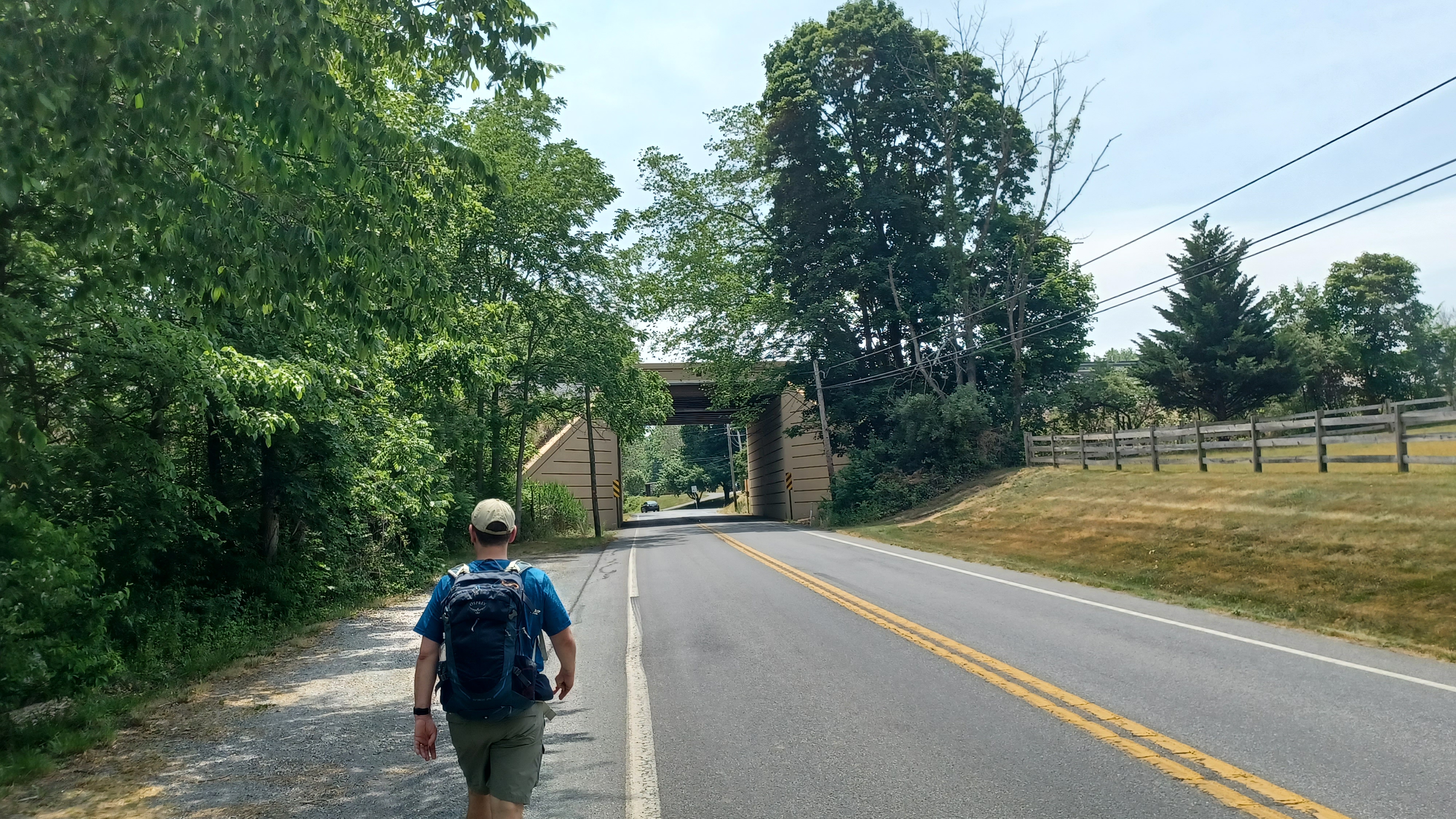
Pretty soon, we reached and crossed over busy Rt 322.

We continued ahead on Pumping Station Road, blazed in this part as the Horse-Shoe Trail where we'd been last month, and continued down to the parking area on the left. This area is the former site of Peter Grubb's Upper Hopewell iron forge, built in 1742. A memorial to this is in the lot, and appears to be made of remnants of the forge, as well as pieces of slag. This spot is the northern terminus of the Conestoga Trail.
The Horse-Shoe Trail westbound turns to the right into the Furnace Hills. The Conestoga Trail takes us along the road to the south, then turns left on Speedwell Forge Road. We continued on this and soon passed beneath the Pennsylvania Turnpike.

Just after passing beneath the PA Turnpike, the trail cuts into the woods on the left, into an area that is signed no trespassing as a private hunting and fishing club, but apparently the trail has permission to use this land.
The markings of this trail vary quite a lot. In the northern and many prominently used sections, it is marked with a sort of mauve or salmon color, a sort of orange. In less used areas, it seems to be marked with pink. In other areas, like this, it occasionally has plastic Lancaster County trail markers, square in shape, hammered to the trees.
This area was mostly orange paint.
The trail starts off grassy, but then there's an oddball section where it goes steeply up, crosses the Hammer Creek on the overpass for the PA turnpike, then comes back down the other side.

For this bit, I was not getting the stroller through myself. I took Ev out of the stroller and carried him through the precarious section, and then Dave managed to get it up and down the sides of the culvert for me.

Once on the other side, it was only a little bit of time with tree roots and such that I had any trouble, and was able to put Ev back in the stroller and push it. He stood in the thing and looked ahead excitedly as we made our way through the woods.
Much of the foot path section was easier on the stroller than I'd imagined it would be.
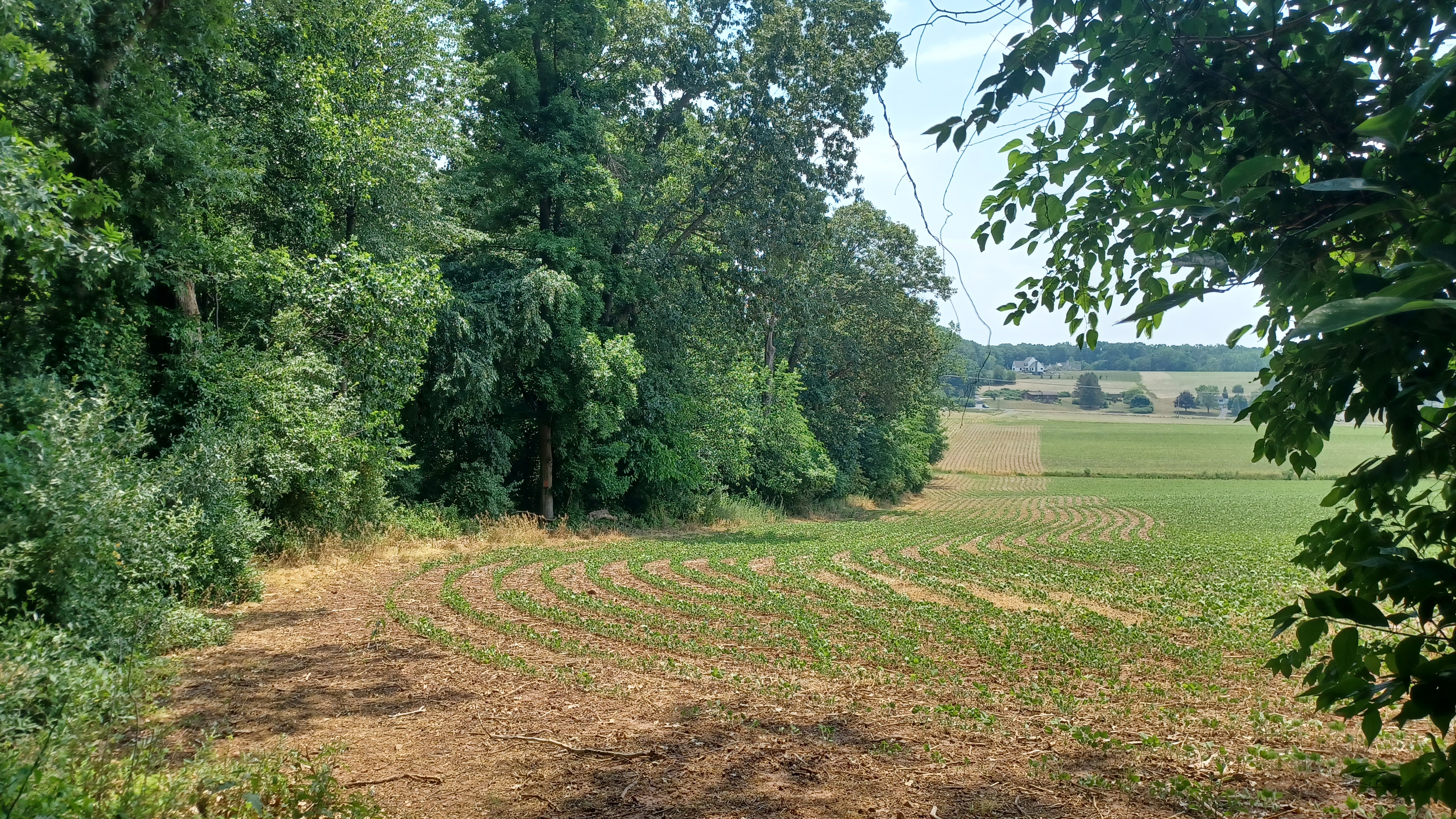
After weaving around in the woods, we emerged on the edge of a corn field, then went back into woods. At times, we were parallel with the fields, just inside the woods. I was impressed that as much of it was clear as it was through these woods.

The section went on for longer than I remembered, but eventually we emerged in the edge of a field and headed south to Long Lane, just a short distance to the west of the little settlement of Brickerville.

We turned left on the road, then pretty soon right into woods again to the south, adjacent to the new DeParrot Woods Nature Preserve. I think the trail remained on its old route though.
The next bit was all just old woods road, which was pretty pleasant. We had a gradual uphill for a while, then gradual down along a small side stream. We crossed the stream on a footbridge, and by that time Ev was fast asleep from all of the excitement. It amazes me how he just zonks out when we get to sometimes the bumpiest of sections.

We ascended a bit from the bridge, and then came to a fire pit, seating area, and amazing cabin of two stories in the slope.

I don't know if this was a trail shelter, hunting cabin or what, but it definitely seemed out of place back there. It also definitely was not there when I hiked through before with Jillane. I understand that now more of this property is preserved, so maybe it is used as a trail shelter, but I don't know. Either way, it was quite interesting to come to, and it was a perfect break spot.
We continued from here uphill further, and Ev woke up near the top. The trail weaved around as a foot path for a bit, passed by an old bicycle, and descended to the edge of Speedwell Forge Lake.


I let Ev out of the stroller to walk through some of this because it was too difficult to push the stroller without tipping it unless it was lightened.

The section was quite pretty above the lake heading south. I told everyone about how Jillane and I stealth camped below the trail in this area, along the lake, when we got stuck in a rain storm years ago.
The trail took us above the lake out to West Brubaker Valley Road.
We turned right, crossed over the lake on the bridge, and then turned left into the parking area for the boat launch at Speedwell Forge Lake.

We continued through the parking lot, and then into the woods on the other side. There was slightly a slope in there, but not too hard that I couldn't get Ev through in his stroller.

Eventually it got a bit tougher, and I tried pushing him through on it, but relented and let him walk with the help of my friends. The trail went along an access road near the dam for the lake, which was narrow, and I could barely fit the stroller through, but was being stubborn about going up to the road when there was such nice trail there.
I got myself ridiculously sweaty trying to get through all that, so when we stopped for a break, I jumped into the water at a point where there were a couple of rocks and cooled off.

From here, we passed through a gravel lot, turned a hard angle up and through a swath of shrubs, then out near the main dam.

The trail followed a mowed path down near the main dam, and then along the Hammer Creek just downstream.
It was a nice and easy walk, and easy to push, on the trail in this section. We headed out to the next road, which was called Old Pike.
Here, the Conestoga Trail used to turn left across the bridge over Hammer Creek, and then right onto private land following he creek to the south. Sadly, the landowners have closed that section, and the trail is now a road walk through that section. We turned right to follow the new alignment.

This area, and the area immediately Upstream on the hammer creek, was once a community known as Brubaker.

Family names such as Brubaker, as well as Snavely, and Hess settled in this area. There was an early dam on the Hammer Creek near the site of the current Speedwell Forge Dam, and it appears several homes in the community were eliminated in that area.
We turned left from Old Pike at a lovely red home with several tiers to the roof levels, which might signify different additions to the house at different times.
We followed Zartman Mill Road to the south from here, which was a route I'd never followed. The area had a surprising amount of healthy Catalpa trees overhead.

It is said that a tea can be made from the Catalpa that could be used as a cure for snake venom. It was traditionally used by Native American Medicine men.

Although more common in subtropical sections of North america, we often find Catalpa along riverside or planted as ornamentals further to the northeast.
In the past, it has been referred to as "Indian Bean Tree" because of its elongated seed pods.
Zartman Mill Road leads out to Rt 501, Furnace Hills Pike, but we got off of it just before that on a short road called Spring Street, which went under one of the brilliantly flowering Catalpa trees. We turned left on 501, and reached the bridge over the Hammer Creek. The original trail used to come out on the other side and cross this bridge.


We continued to the right into the woods on a very surprisingly nice mowed path beside the Hammer Creek. This was a rather still section because there was slack water fro a small dam downstream.

This was a section I particularly loved because it was so odd when I backpacked it. We headed along the stream a bit, to a swampy area, and then rather steeply uphill and along a sidehill bit until descending to the Snavely Mill Dam and spillway.
The trail does this odd thing where it crosses a narrow bit of concrete over the mill race, then turns right next to the dam to follow the mill race downstream.
I was really hot, so I went down into the raceway and laid in it for a bit.


Ev was out walking, and started heading toward the raceway, which freaked everyone out because they thought he would try to walk over it. I'm pretty sure he wouldn't have, because he gets afraid when it comes to heights like that and won't get too close.

I climbed back up from there, and we all continued along the raceway downstream.
The trail occupied a pretty narrow spit of land between the creek and raceway for a bit, and then made its way downstream, then the creek moved off more to the left. This entire section, before and after the raceway, was full of amazing giant trees.
We continued along the raceway, and the trail was still surprisingly nice to walk. No bushwhacking, as it had been rather recently bush hogged.


The original mill was constructed in the 1860s on the site of an earlier mill, and it was purchased by the Snavely family in 1875.
The mill suffered a devastating fire in the 1980s, which led to a complete modernization of their flour milling process.
The Snavely Mill is one of the oldest family owned flour mill operations in America, processing 20 different grains at 3 locations, with their own fleet of trucks.
The family believes in giving back to the community, and one of their contributions is allowing the Conestoga Trail to pass through their lands, including this section of the historic mill race.

The trail reached Snavely Mill Road, and turned to the left to cross the Hammer Creek. It went uphill slightly, and then turned right into the trucking area of the Snavely property.


The trail went on back to the rear of that gravel lot, and then continued through fields to the right, closer to the Hammer Creek again.

This was a nice little section, and some of the group cut the corner through the fields while I pushed Ev more to the right and closer to the creek. There was a spot with a rope swing I recalled in this area, but they passed it.
We continued around a corner, and I stopped with Ev to take a dip in the creek at the next good place I saw. I couldn't pass up any more of them because I knew we would be leaving the creek somewhat soon. There had been another reroute in the area up ahead, and this would be possibly the last chance.


When I felt cooled off, and Ev was happy with the amount of debris he had thrown, we headed back up to the trail and continued to the east.

The trail brought us from field edge back into the woods again, on another nicely mowed path.
The trail continued as a good mowed route along the creek to a point where it turned abruptly to the left and up to Snavely Mill Road, just before reaching a very picturesque pond.
The trail followed the road ahead, and just ahead reached an old house which was once a flour mill, also owned by the Snavely family. We continued past that and turned right on Brunnerville Road.

We crossed the Hammer Creek, and the trail used to turn to the left along field edges from there. It was there the last time I did the trail years ago, and it was a bit of a rough stretch I recall. It's still sad that the section is now closed.

Now, the trail continues uphill gradually on Brunnerville Road. As we gained some elevation, it afforded us some pretty good views of the area.
The road section was busier than I care for, but it was okay. This was the home stretch.
We headed toward the top of the hill, and soon approached the center of the settlement of Brunnerville.
The community was named for early settler Peter Brunner.
The settlement started to take shape in the mid to late 1800s when people were moving from nearby downtown Lititz to the South.

Conestoga Trail makes a hard left turn on Hackman Road and continues back down to the Hammer Creek, but we'd save that section for next time, and continue straight on Brunnerville Rd.

The Brunnerville Hotel, which is situated at the was opened by A. M. Bruckhart in 1861. It passed through many hands over the years, and as such took the name of different proprietors.
The hotel remains opened as a bar and restaurant to this day.
The establishment is only two tenths of a mile off of the route of the Conestoga Trail, and an excellent place to stop for food and drink, so it should really be in the trail guide I would think.

When we met at the school in the morning, there was a neighbor that came out and chatted with us briefly. He told us that the Brunnerville Inn was a "strange place", that they have really good greasy burgers, but that if we went in there, everyone's heads would turn because they knew we weren't from around here.

I didn't care much about that, and when we got done in reasonable time, and everyone was interested in stopping for food, plus it was only a few blocks away from where we parked, I was totally for stopping.

We went out back for the outdoor seating, after I first pushed Ev inside the tight front door with some difficulty.
I had to lift the stroller up to get up the stairs in the back deck area, but it was otherwise a perfect spot to finish off.
I ordered the burger as was recommended to me in the morning, and more specifically the Brunnerville Burger, and it was absolutely amazing. Just mouth watering awesome.

Ev had some of the burner, but at a lot of my fries, which he loves. I also had one of their IPAs.

This was such a great stop, and aside from when I first went through the front door with the stroller, we never really got any strange looks that I noticed.
We finished our food, and it was only a short distance across East Lexington Road and down Brunnerville Road to the John Beck School parking lot and the end of our trip.
I think the trail lacked some of the excitement I felt the first time I had done it, maybe because I knew some of what to expect, but I still love it very much.

It's just not the normal type of trail, and I think I may have played it up too much for my group, who are used to some really outstanding stuff on the hikes.

I was glad to have seen a lot of new stuff, and really felt like this one was quite an enjoyable one, and I was looking very forward to the next ones in this series.
There's been so much stuff going on that I've been looking forward to, and no shortage of stroller-able trips in the future. Little Ev is coming along so fast with his walking, we'll be using the stroller less and less all the time. In some ways, I'll kind of miss it, because it has its advantages too!
I'm just going to enjoy every moment for what it is, and hopefully he'll want to keep with it too.
No comments:
Post a Comment