

Hike #1578; 11/12/23 Bear Mountain to Cornwall On Hudson with Serious Sean Dougherty, Robin Deitz, Jenny Tull, Diane Reider, Rob Farrell, Mike Selender, Alyssa Lidman, Russ Nelson, Lynette Rorer, Dan Asnis, Evan "Joe Millionaire" Van Rossum, Justin Gurbisz, Brittany Weider, and Everen

This next trip would be a point to point hike in our Hudson River Greenway series. I pushed this one a bit further up on my priority list based on some circumstances that we just couldn't bear to miss out on.
That major item of interest would be the Storm King Highway.
This scenic highway around the outside of Storm King Mountain was for a time closed on Sundays to allow for pedestrian use of the scenic route, but it was not certain if this would happen again soon.
Then, during the major flooding that had occurred just a little earlier, a large section of the highway was completely washed out. The stretch was closed to all traffic, and it was unforeseeable if it was going to ever be opened again.


I had to see it. Before it got to be too popular and was blocked off more, or before they decided to fix it, I had to see it.

As such, this hike, even though it was not really the next one on our agenda to do, it had to get pushed up the priority list.
As usual, the beginning and end of the hikes are the parts that are hardest to try to plan. I always have the bulk mileage in between, but where to park at either end and those couple of miles attached to that are the toughest.
The end, I decided, would be at Cornwall on Hudson NY. I chose the Estie and Hellie Stowell Trailhead at the base of Storm King Mountain, where the Highlands Trail passes through, as the meeting point. We would then shuttle with as few vehicles as possible south to Bear Mountain State Park NY.


The end, I decided, would be at Cornwall on Hudson NY. I chose the Estie and Hellie Stowell Trailhead at the base of Storm King Mountain, where the Highlands Trail passes through, as the meeting point. We would then shuttle with as few vehicles as possible south to Bear Mountain State Park NY.

When we got to the trailhead, I was concerned that it might be an issue having cars there after dark, just in case it took that long. I didn't want to chance it, so we moved all of the vehicles a little farther to the north to Hudson Street in the town proper.

We shuttled south to Bear Mountain State Park, and actually paid to park in the big lot. That had not been my initial plan, and I didn't think they would be charging a toll, but we got stuck with it.
Had I realized that ahead of time, I would have chosen another nearby location that would have been better.
We just made the best of it, parked, and started heading out on our way.
I had wanted to start around this area because I had some historic postcard photos of the Bear Mountain Inn that I wanted to get modern versions of for the Metrotrails page.


We continued along the edge of the lake to the north. Despite it being rather chilly out, there were a lot of people hanging out around the lake.

At the end of Hessian Lake, a paved trail makes its way gradually up to Hessian Drive. From there, we would have to be on the roads for a bit, so I made Ev get into the stroller.
We turned right to cross Rts 202 and 9W just below the Bear Mountain Circle, onto the service road that heads over toward the Bear Mountain Bridge.
We came to where the Appalachian Trail crosses the road just to the west of the bridge, with good views of the old toll building.

The Bear Mountain Bridge was originally supposed to be a railroad bridge, where work started in the 1880s.

Work had “progressed rapidly” on the footings to this bridge, but it stalled out and was never completed for it’s original intended use. Instead, the highway bridge was planned, and eventually completed in 1924.
At the time of it’s completion, it was the longest suspension bridge in the world, a distinction it held for only 19 months, when that title was taken by the Ben Franklin Bridge between Philadelphia PA and Camden NJ.
We crossed carefully, and I took some photos. I had wanted to try to get some then and nows using some historic photos I'd saved to the phone, but I couldn't find anything in my collection.

That's getting to be a problem; I don't have the time, or I don't prioritize enough to get those photos ready all the time before the hikes, and then I can't find them at the spur of the moment when I need them.

I had wanted to go down to the Popolopen Creek from here, but it looked like some of the area was closed for construction. I also had a lot of stuff I wanted to do, so I didn't want to take extra time if I didn't need to.
Instead, we crossed and continued on 9W north across the Popolopen Arch Bridge. This is a deck truss structure with an arched frame completed in 1936 to replace the previous 1916 steel span, which was immediately downstream from the current one. During the American Revolution, there was a sort of pontoon bridge over the mouth of the creek on the Hudson.

The walkway on the east side afforded a splendid view of the confluence of the Hudson and the Popolopen.

In 1609, Henry Hudson, while searching for a gateway to the west, moored his ship, the Half-moon at this location. A replica of it was moored here in at one time as well.
The former West Shore Railroad, still a very busy freight line, still spans the end of the creek, established about 1872 here.
The most modern bridge is the trail bridge between the highway and railroad, a suspension structure on or about where the Revolutionary War era structure was, and it carries the Twin Forts Trail. This trail goes between the sites of Fort Montgomery and Fort Clinton, and it is the route I originally intended to use.

Walking across the higher bridge was actually good for this time, because it allowed me to get a couple of then and now shots of the bridge.

Once on the other side of the bridge, we went a bit farther, and then turned to the right into the historic Fort Montgomery site.
The area has been cleared out so all of the ruins at the site can be more clearly seen, and the first we came to were the foundations of the officer's quarters on the right.
The complex was built in 1776, and it was one of America's earliest militarized strongholds.
The Fort was destroyed by British forces in October 1777 when some 900 men of British forces came around the back side of Bear Mountain and attacked, while the remainder of their 2100 men Army took Fort Clinton just to the South. West Point, to the north, became the strategic focal point after that.

We continued ahead, and soon came upon the guard house complex. I let Ev out to walk more at this site, especially after we got to viewing platforms. There was a good little bridge over the entrance to the powder magazine.

The site had excellent walkways around it, which we traveled around in a counterclockwise fashion to the former baracks site. Each area had good interpretive markers telling the story of what the ruin was.
Near the point where we would turn around to head back out to 9W, there was an enormous glacial erratic in the middle of the fort site.
Justin and Brittany climbed onto the top of the thing, and then helped Ev up so that he could see from u on the rock. He loved it of course.

We weaved back toward the highway and left the crushed stone dust trail over grass to get back onto the highway, and then started heading to the north.

Mine Dock Road descends to the river from here, which was the historic location of the "Mine Dock" on the Hudson, dating back to colonial days. It was also the location of the Fort Montgomery Station on the West Shore Railroad. A tunnel also goes through a rocky outcrop below.
There was a pretty good view out ot the Hudson from this bridge as well.
From here, there would be a lot more road walking on the hike, but when it comes to the Hudson River villages and towns, there is always something interesting and significant to see.

The next thing we came across was a lovely old stone church across from us on the west side.

St Mark's Episcopal Church in Fort Montgomery is a wood, stucco, and cobblestone Tudorbethan style structure completed in 1923.
It was built here to coincide with the completion of the Bear Mountain Bridge and nearby Popolopen Bridge, to serve the abundant numbers of vacationing public.
We continued on just a little bit, and on the right was the "Little Brown Church In the Dell", which is a United Methodist Church, and the first church constructed in the area, about 1830.

In keeping with the theme of churches, we soon passed the Blessed Sacrement Chapel on the right, a handsome stone structure. I don't know the year of construction on this one, and I couldn't find any answers on a bit of an internet search, but it certainly does not look like the modern chapels.

Nearly across the street from this church, with a safe crosswalk to go over, was the Chestnut Mart, so we stopped to take a break and get some snacks. I always want to try to grab something for Ev to keep him happy in case he has some sort of tantrum. A peanut butter cut pack almost always does the trick.

After the stop, we continued to the north along the road a bit more. We passed an old eating and drinking establishment called the "Old Oak Inn", and there was a giant white oak in front of it, dead and chopped off some twenty or so feet up. It was a sad sight to see.

We turned right here on a side road called Montgomery Road, a more pleasant and far less used alternative to the larger 9W.

Almost immediately, we went by the pretty Garrison Pond, which had an old mill wheel on display.
There were a few ups and downs on the back streets, but nothing too terrible. The relaxing walk eventually took us back out to 9W and we walked a little further to the north.
We stopped at another little mini mart, this one a Mobile station where there was a guy with a Honda Element. I noticed that this guy was having the same problem I'm having with mine: the back wheels are flaring out and wearing down too fast.

This is apparently a problem with most all Honda Elements. The guy told me he was selling his, and I let him know I was having the same problem to politely show I wasn't interested!


In the distance, the pronounced Sugarloaf Hill was in view directly ahead.
We could not have picked a better time to be walking this road, because a bridge closure further down it left it almost devoid of all traffic. It was quite nice.
We continued to the north along the road, with some seasonal views to the Hudson River to the right. Soon, we were parallel with a pretty cemetery, with more good views toward Sugarloaf Hill.

This cemetery is the final resting place of Benny Havens, who ran a popular bar and eatery in the town of West Point frequented by cadets. So popular was he that to this day, cadets sing songs in reminiscence of the man who has been dead since 1877.

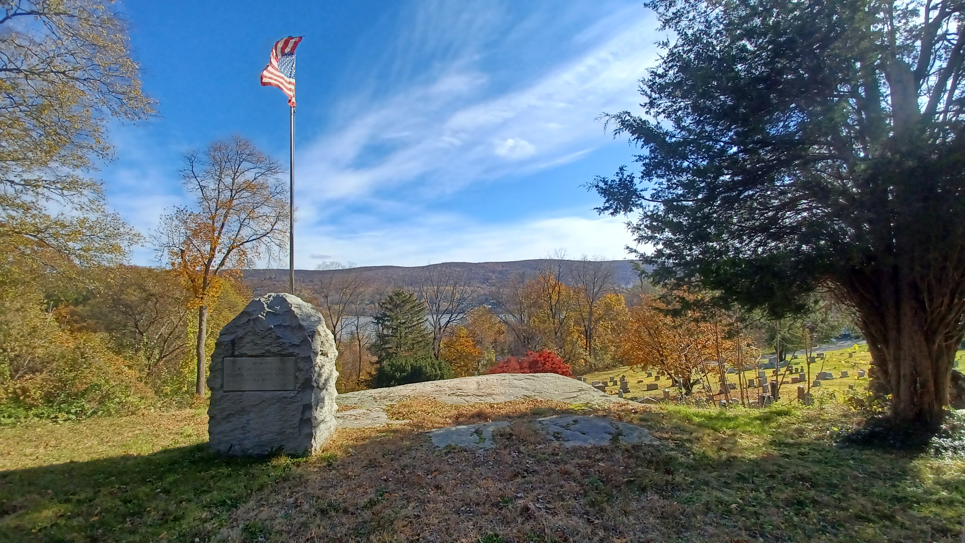
We continued up the road, and there was a Benny Havens historic marker, followed by a very nice veterans memorial at a better view over the cemetery.
We continued on down the road, and came to the spot where the bridge was being worked on over a stream that was the outflow of Crystal Lake and some other water bodies to the west.
I was a little worried going to this point, that we wouldn't be able to get through at all. If that was the case, we'd have a long walk back and around on a not so fun highway.

Fortunately, we were able to get through using the construction crossing, and with a little help, we got Ev and the stroller right over all of it.

We went uphill on the other side, and then approached a driveway called Cragston with an historic marker.
The historic marker denoted the final residence of Margaret Corbin, one of the women labeled "Molly Pitcher" during the American Revolution.
Her husband, John Corbin, was killed while manning a cannon in defense of Fort Washington on Manhattan Island. His wife took his place and continued to operate the cannon until she too was badly wounded.
She became first woman in history to receive a pension from Congress for military services.
Margaret Corbin died in Highland Falls in January 1800.

We continued ahead on the road for a bit, and there was a Mexican restaurant on the left that had sculptures of a horse and cactus and such made all of horseshoes.
We continued further into the village of Highland Falls, and I continued singing bits of Billy Joel's "Summer Highland Falls" song, with the the emphasis on the "sadness or euphoria" bit.
We met up with Russ near the Veterans Park area where the road split, and we stopped for a little break at Brothers Pizza I think it was on the left near there.

There is more to see in this area, in particular the "highland falls" for which the settlement takes its name. I definitely need to do another trip over there.
I had looked up some of the information on West Point Military Academy before going there, thinking we would hike through the facility, in the gate from Highland Falls, and then out the west gate to get back on the closed Storm King Highway.

This didn't work out as planned. We walked to the north and headed toward the gate. Rob's wife works at the place, which I didn't know ahead of time, and we'll have to coordinate with him the next time we try to go through this, but this time it didn't work out as planned.
I clearly did not have everything in order the way I thought I did from just making phone calls and staying on hold for a while during the week. The officers I spoke to were not aware of what it would take to get the group in for a walking visit.

When we approached the gate and got turned around, we had to go back to where the museum area was, which I also wanted to visit, but at this point it was going to run a bit late.
We went inside the building where we'd have to go to get permission to go in. Everyone took the stairs except for Ev and I, because Ev and I had to take the stroller into the elevator.
We took it to a lower floor, and through a corridor with a waiting room. Each person had to go up with ID, and then fill out paperwork. The girls that were running the desk were beyond annoyed.

They told us each one of these things might take us 45 minutes. We might be waiting there for hours before we could get the entire group in.

I waited for a few moments, thought things over, and then called everyone together to officially bag my original plan. Fortunately, I had gone over the route and was already ready to circumnavigate West Point by way of other roads.
Like usual with this type of thing, I had to come to terms with the fact that I'd changed the hike and how we were going to get through. I had to start looking at the phone GPS aerial images and make sure I was going to put some worthwhile stuff into the alternate route I had planned. I would have to make sure the new turns that I was going to make would take us where we needed to go.

More historic churches were of course among the interesting points along the way. The United Methodist Church of Highland Falls was originally built as the First Presbyterian Church of Highland Falls in 1868.

It is a granite, Gothic Revival style structure designed by Frederick Clarke Withers.
The Church of the Holy Innocents in Highland Falls NY.
Designed by Robert Walter Weir, and completed in 1847, and so named for the children of Weir who died young.
We walked right through these church grounds, then turned left on Church Street at the top. We turned right on Cozzens Avenue, and meandered some of the back streets to the west.

I think we ended up on Schneider Avenue to West Ave, on a weird route close to traffic that was really steep to push the stroller up.

We came to Mountain Avenue, Rt 218, and continued gradually uphill, soon parallel with the Highland Brook. To the left of us, the brook was pretty through the trees, with stone remnants of two old masonry dams.
The first one was totally purged out and flowing through, but the second one still had a picturesque cascade flowing over the top of it.
I was a little nervous about the part coming up. 218 was soon merging with Rt 9W, which was large and had limited access to some degree. There was an exit to Stoney Lonesome road into West Point.

We crossed over directly, and continued onto the on ramp to 9W. It didn't feel quite right walking this route, but there was no other choice because of where we were.

There was plenty of shoulder room, and it was only three tenths of a mile to the next pull off onto an older road, and we made it with no problem.

Pretty soon, we passed the Catholic Cemetery of West Point on the right. Just behind it was the Eagle Valley Cemetery, which I considered walking into and trying to get around, but I'm not sure where the West Point boundary is, and I didn't want to have any kind of problem.
We continued past some road department buildings on the right, and then a path led directly into the golf cart paths of the West Point Golf Course.
There was a foot bridge over Rt 9W, and standing out more obviously than any other text were the words "open to public". I looked at that like an invitation.

We reached the cart path, turned left, and crossed 9W on the pedestrian bridge. We came to the edge of the course on the other side and followed the cart paths to the right, at this point parallel and barely visible from 9W.

There were a few people playing golf in the distance, and we steered clear of them where we were. When the path turned to the left, we cut through the grass to the area below. A right turn here led out to an apparently seldom used paved path out to the ramp connecting Rts 293 and 9W.
We kept to the left, crossed the on ramp, and the barely used paved path followed the Storm King Highway beneath 9W. We then followed Rt 283/Storm King Highway to the north, parallel with the golf course. Justin went up onto the golf course and walked on that for a while instead of the road.

"Duty Honor Country" was written on the golf course buildings, and the like. The area where we came to the turn between Storm King Highway and 9W is known as Deep Hollow.

I was surprised by how much traffic was actually on this section of road that was closed as a through route. I didn't expect that much traffic would be going to the golf course in such cold weather.
There were some little cascades on the left side of the road as we continued, and then there was a clear spot on the left with a giant likely oak tree, probably where a house once stood.
Much of the land on the left was military owned which had some very foreboding signage on it. I was surprised no one came out to talk to us about where and why we were walking the direction we were.

We passed the entrance to the golf course, Victor Constant Road, and then soon Washington Road, at the western gate of the military academy.

We were on a public road, but it was closed to vehicular traffic north of this gate. Because of that, my fear was that the guard at the shack would come out and tell us not to go in there. Maybe because the land around the road was posted as government property.
There was a path around the left side where it was obvious people had been going through here and there, but not that often. I had to get some help to get the stroller through it.
The guard in the shack didn't seem to notice at all until the last of us were making it through. Then, he stepped out and looked on at us passing through. Still, no one was dispatched to the site. Maybe they figured we would be coming back the same way, because there was no way we would get through.

We had a very pleasant walk from here for a good long while. There was no one around, and the highway was completely devoid of all traffic evidence. The yellow lines were still visible, but the edges covered with leaves where obviously nothing had worn or pushed them off.

We pushed along quickly while we were still close to buildings, and across the Crows Nest Brook.
Beyond, we were up on a higher shelf where the highway rose above everything. We could occasionally see some buildings below us when we were looking, but otherwise we were totally out of sight.
There were some pretty huge barricades placed, as well as big chain link at either end. If anyone needed to get in beyond these gates, it'd take some effort.


I let Ev out of the stroller pretty soon after we got on the road, and he was moving along at a pretty good pace.
We made our way downhill for a bit until we came up on the Lee Gate, and then continued on to the north. I didn't see anyone in there, but I think someone in the group mentioned a car pulled up and watched us.

From that gate, there was a good view of the rocky formations coming up to the edge of the highway ahead.

The coolest part of the hike was just beginning here, but I was getting a little worried that there wouldn't be a whole lot of daylight left.

Russ knew this. He started powering ahead because he wanted to try to get the sun setting just as we reached the pinnacle of the historic highway.
Dan had ended up really way far behind us. We had been walking through the golf course the last time I saw him, and he was a bit farther behind, but not too bad.
When I turned off to the right, toward Storm King Highway, he was in sight, and I figured he saw me pretty well, but then he wasn't catching up and we couldn't dillydally around by the gate for him.

I finally heard from him after we onto the highway. He had continued on the golf course path and had gone the wrong way to the south when we were all going north. This set him back a lot.

Fortunately, I was able to get him back on track heading toward us. I was worried about him being so far behind us, that he might be the one to get stopped, since the rest of us were all seen going through.
Dan stayed in next message contact, and I called him a few times to make sure he was still coming up closer behind us.
He made pretty good time, and I talked to him right after he had made it through the left side of the gate, and then just after he had passed the Lee Gate.


Justin was making me nervous walking along the tops of the old stone walls behide the edge of this closed off highway. They were clearly all damaged, not only from the Summer storms that led to the closure of this highway, but from years before.

Along the edges of the road, there were some catch basins that were badly collapsing. Ev was loving walking through the dead leaves, and I realized quickly that there might be holes in the surface, through which he could fall, and we just couldn't see it. So I kept him from walking in them more.
We continued uphill a bit, with some more views across the Hudson to the right, and then gradually back downhill.
In this section, I began seeing what the problem was on the road. There were a few minor problems, but there was one very major washout to worry about.
There was a backhoe parked on the right side as we were approaching the site of the washout.
This was far worse than I had anticipated it would be. The drop was pretty much right down to the former West Shore Railroad tracks. That had already been cleared soon after it happened, but the road was entirely gone through this section.


It was a bit unnerving approaching the collapse spot, because we couldn't tell if anything of what we were walking was undermined at all.


We inspected the site to see if there was going to be any good way of getting through. One slip up would be a long fall down.

There was actually a pretty easy way to go up and around, and most of the spot lower was still pretty easy, but there was one spot where some water was flowing near the end of where we would have to step.
There was no carrying the stroller through this with Ev in it. I would have to take him out and carry him over it very carefully, and have spotters in place just in case. I was confident with my footing, but I couldn't chance anything bad happening to Ev. If it weren't for him, nothing of this would have bothered me.
Russ got to the other side and waited for us, and then was ready to help when we got to that tough spot. I walked over there with Ev, and then handed him over the one weird footing spot, where I actually almost slipped.
The rest of the group helped to get the stroller through for me. They carried it further up the slope to keep better footing. I walked Ev up the road to hang out with the others at a far enough safe spot, then returned to have the stroller passed off to me.
It really was overall pretty easy, so we didn't worry too much about Dan on it. We took a break at a spot a little further ahead, because Brittany mainly was worried that he might have an issue there.
It took us a little time to go through, and I talked to him on the phone just as he was approaching the site. I figured he would be right there, but Brittany knew it might be a problem, so she went back to check on him.


It was a really good thing she did this, or more of us would have been going back later, and closer to dark.


Dan had walked over some of this, and made a wrong step. He fell down into the collapse, where the ground let loose beneath him.


Some of the group went back with Brittany to check on him, and found him like that, and the story I was told was that they lowered Brittany down to grab hold of Dan, and helped to pull him out.

When Dan caught up with us, he was actually totally fine, barely any scrapes thankfully. He said he felt fine and shrugged it off pretty well.
He would have been okay either way, but Brittany saved us a lot of time and stress by going back to check on him.
Once we were all across that mess, we knew we wouldn't have any other problems.
When we first made it over the mess, there was a couple walking their dog there, and they told us it was pretty clear sailing from there all the way back to Cornwall On Hudson.
The rest of this hike was going to be nothing short of a great joy.
I think I had a Four Loco on this, because I wanted to pick up something cheap and strong earlier in the day, where if I had to throw something out because of going into West Point, it would end up being something cheap that I didn't care too much about losing.
The road descended a bit, after passing around the heights of the land around Bull Hill, and then went into an area known as The Clove. In this area, the former West Shore Railroad goes out onto a causeway on the Hudson to be straighter.
We gradually descended, and then came to where some of the trails of Storm King State Park terminate.


The small parking areas were all vacant. I figured that the road couldn't really be considered closed when all of it was accessible from this trail system without any signage on them that the road was closed.

Below us in this area, there was an abandoned comfort station building that looks similar to those in Harriman, and other things associated with Palisades Interstate Park Commission from NJ north on the Hudson.
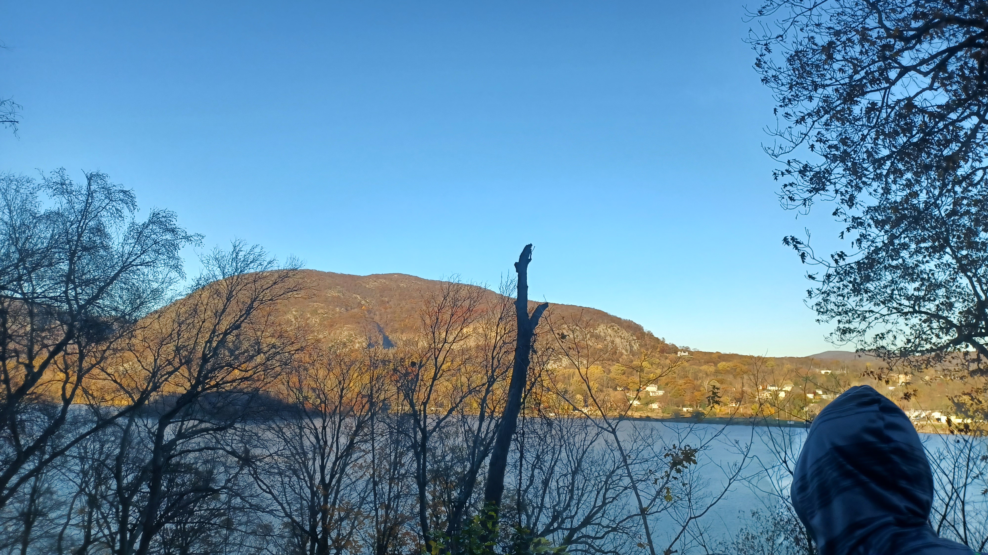
There was a great spot with a view looking to the north through the gap in the Hudson Highlands, sometimes referred to as the "Twin Sentinels, Storm King Mountain to the west and Breakneck River to the east.
We could see the Storm King Highway in the distance, where we were headed from this point, and the sun was going down fast. I didn't want to sit still for too long.
Russ called me to let me know it was just about the sunset and he had arrived at that high point. He would wait for us there.
On the left, there was a spring with a large rock placed in the middle, which was some sort of famous roadside spring back in the early days of the state parks in the area, as well as the highway.


From this point was the final ascent to the highest peak on the edge of Storm King Mountain. It wasn't too tough to walk up, and it looked as though we were going to catch it before it got too dark.


There were fantastic views on the way up. The causeway of the West Shore Railroad was unobscured in view to the south as we reached the height of the road.


A giant rid and black ship was passing through these narrows just as we reached the top, which served to further define just how far up we were from the river.


Through these narrows, Bannerman's Castle on Pollepel Island was in view.

Bannerman's Castle is an abandoned military surplus facility built in the form of a castle on the island. "Pollepel" is a Dutch word for "pot" or "ladle".
The island is named for Francis Bannerman VI, an arms dealer who purchased the island in 1900 to serve his growing surplus business. He began building his arsenal at the site because his New York City site was not safe to store his thirty million surplus munitions cartridges. Bannerman designed the place on his own, and let the constructors interpret the designs on their own.


Bannerman built a residence castle, smaller, on the height of the land on the island. Bannerman provided munitions from the site in 1917, but he died in 1918. In 1920, some 200 pounds of shells and powder exploded, and destroyed some of the complex.

The ferry boat "Pollepel" served the site, but it sank in 1950 during a storm, and access to the island was pretty much cut off. The state purchased the island, and gave most of the historic military items to the Smithsonian. Tours were conducted on the site in 1968, but the buildings were all gutted by fire in 1969. The place was made off limits to public after that.
More of the castle collapsed in 2009, and there is a friends group working to try to stabilize what is left, but it is uncertain what will become of it.


It was a little tiring getting back later than anticipated, and having to deal with a couple of mishaps, but nothing too serious in the long run.

It had been a really spectacular day, and I was really glad we had done this when we did. In the days following it, Rob had said there were talks about never re-opening the road again, because it simply isn't necessary with the newer highway just to the west.

In truth, it probably would be better served as a multi use trail, but a lot of people complained about it.
The latest I heard is that the road is going to be reopened just as it was before, to vehicles. This surprises me, but it's alright. In the couple of weeks following this hike, an access was constructed down into the washout to begin the process of repair. It was a good thing we walked it when we did, as we might not have gotten away with it just a little later.