

Hike #1490; 6/16/22 New Hope and Lambertville Area Loop with Shane Blische and Everen
This next trip would be another one in the Lambertville area, looping to New Hope and covering canals and rail beds again.

I hadn’t hiked with Shane in a while again, and so I called him
about this one.
It was another weekday adventure where I had to bring Ev to his
physical therapy appointment, and so I had off work. I moved those appointments
to earlier so that I could get some hiking in.
I parked over in the lot behind the Lambertville Station
restaurant, and then headed along the old Bel Del Railroad tracks and Delaware
and Raritan Canal heading back to Bridge Street.
Along the way, there were lots of Day Lilies growing along the trail.

The attractive, common
perennial flower lasts only about one day, hence its name. However, it is often
amazingly replaced by another one on the same scape in a single day.
It is actually not a
true Lily, but rather in the family Asphodelaceae.
Daylilies are native
to Eastern Asia, and have been growing wild as well as cultivated for thousands
of years.
Every part of the Day Lily is edible, and can be used in many dishes. However, eating too many of the flowers could cause diarrhea. Some species are poisonous to cats.

Little Ev is only allowed to try one wild edible per week, and I take it away after a bit. This is to make sure he has no allergic reaction, and because his safer portion would be less than for an adult.

We reached the bridge over the Delaware, and walked across
admiring the view downstream.
I was surprised to see
a helicopter going back and forth across the river. I had seen this before on
the Susquehanna River. They were spraying something, which appears to be aerial
black fly suppression operation between Lambertville and New Hope.
They are likely
dropping VectoBac, a biological larvicide used to control black flies,
mosquitoes, and other nuisance flies.


The substance is the only of its kind to complete the World Health Organization Pesticide Evaluation Scheme.
Once across, we headed to the left onto the Delaware Canal.
Shane joined us from his house in this area. We soon reached and crossed the
Aquetong Creek Aqueduct, and then passed by Lock #11.
There were four consecutive locks in close proximity in New Hope. The canal here was built in 1832, originally the Pennsylvania Canal Delaware Division. It was built by the state to extend commerce, and later most of the state canal system was sold off. The Delaware Canal however remained in operation thanks to the Lehigh Coal and Navigation Company.


New Hope was already a prominent location prior to the canal, and it was named for the “New Hope Mills” that were constructed, bringing new hope, after the originals were destroyed by fire.


Commerce of course grew because of the locks. With four steps of locks, boats would have to wait for the previous one to lock through before they could go through.


If there were two in waiting between the locks, it was a convenient time to step off and purchase or barter for supplies. The traffic got so busy that all of the locks here were doubled in the 1850s.

We got past the first lock, and then descended to cross over Rt
32. My plan was to head south to Washington’s Crossing, cross the Delaware, and
come back on the old Bel Del on the other side.
I had several then and now shots I wanted to get of the area, so
we would spend some time on that.
There were steps down from Lock 11, which meant I had to go slow with the stroller. There is also a weird dinosaur sculpture at the edge of the canal that I have no idea what it’s about. It’s been there for years.

Lock 10 is now buried beneath Rt 32; it is one of the only locks on the canal that is now completely obscured, and one of the most substantial breaks at the near sixty mile length.

To the right, the old River House, a handsome stone structure
that used to stand adjacent to Lock 8, stood in its new location. They moved it
up the hill from the original location because it kept getting damaged due to
flooding. It was an amazing feat to move the entire historic stone structure. I
was glad to see it was saved.
We descended from lock 10, and then reached lock 9, which is
intact. Another improvement that was made with these locks were drop gates on
the upper end, which allowed for quicker use of the locks in later years.
To the left, we could see through the trees at the outlet lock to the Delaware River. Around 1850, navigation began on the Delaware and Raritan Canal Feeder on the NJ side, and so outlet locks were placed on both canals on both sides. Boats could then travel out of Delaware Canal, cross the Delaware River using a cable ferry, and then lock in to the Delaware and Raritan Canal for a shortcut to New York City.

Wing dams below Lambertville and
New Hope exist to provide the slack water in the Delaware needed or this
navigation.
I got a pretty good set of photos of Locks 10 and 9 area, and
the building I think is the lock house is still in place at Lock 9.
Just ahead, where the River House used to stand, there is now a brand new
building. It is still an upscale restaurant like the River House was, and has
some stone façade to it as well as a big fire place on the one side that looks
like it is intended to emulate the one from the inn that used to be there.
We went by lock 8, which no longer has a lock house either, and I got some more shots. We then went to the left a bit, and checked out some of the outlet canal. It kind of lost some of its ambiance with the construction of the new building between the connection between the main canal and outlet channel.


I had Shane stand with Ev for a few moments while I ran across to the other side of the Delaware Canal to get a now version of another historic shot, which showed from a distance where the two channels came together.


Once we were done there, I headed back down and we started following the towpath south some more.
There was a lot of vegetation coming in on the edges, and some more Day Lilies. I gave Ev another one to eat as we moved on.


There are newer apartments and town house type residences on the left side through this area, formerly the Union Mills Paper Company paper mill.


One of them was the office building associated with it as I understand. Just below this spot, there was a fifth lock.

This was an unnumbered lock with negligible
lift, which helped to serve the Union Paper Mill with water power, and as I
understand, the amount of lift depending on the water use out of the canal
there. Shane explained that it was simply known as the Paper Mill Lock.
I could see gate pockets in the canal at that point, and I’d
never heard of this until recently.
I did another then and now at one of the bridge accesses, and we continued past the condo areas to the south. The canal got to be much more bucolic after this point.


There is a side trail up into Washington’s Crossing Historic Park property, which I believe we took this time. We paused when we got near a pavilion area with a garbage can so that I could give Ev a diaper change.

The area isn’t specifically at Washington’s Crossing, but some of the
continental army did cross in this area. The crossing of all of those soldiers
did not take place only at the spot today known as Washington’s Crossing. They
were up and down the river through the area.
We continued back around to the towpath and continued south, and
soon passed the Thompson-Neely Bridge.
This bridge is one of only six remaining authentic camelback truss bridges
spanning the Delaware Canal that were erected while the canal was still in
service. I always liked that along the canal, even when they are not weight
bearing trusses, they have adopted a brand that looks like these.

Concrete
bridges are adorned with red trusses that complement the ambiance.
Next, we reached the Pidcock Creek Spillway.

The Pidcock Creek does not have the aqueduct beneath the canal, but rather
serves as another feeder to the canal. Directly across from where the creek
flows in to the canal, there is a spillway so excess water can flow over and
not wash out the towpath.
I had never been to the Pidcock spillway while the water was this high. I
approached and found it to be a bit unnerving. I could carry Ev and the
stroller across, and I know I could get over if I were out there on a regular
hike, but with the stroller it might be dangerous.
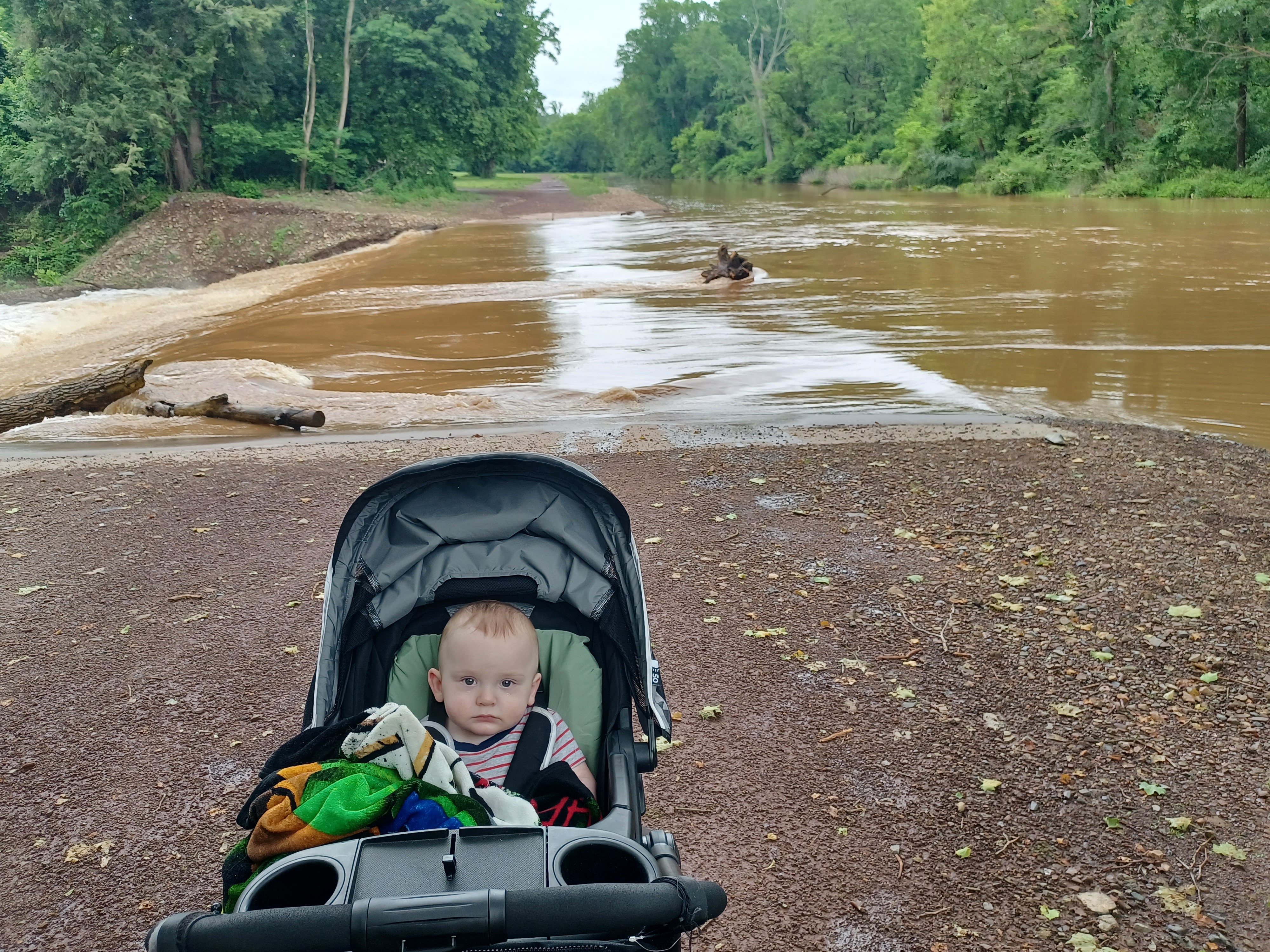
I had Shane stand with Ev, and I walked ahead to test the depth and current.

The spillway was slippery, and the current very strong. I could have gotten
myself across with care, but there would still be the chance I’d get swept over
the side. I could not take that chance with Ev. The entire hike had to change
here.
I paused and thought this through for a bit, and then decided it would be best to head back to the north, and then we could head up to Stockton and Centre Bridge. We could take on some excess mileage by heading across to Lambertville first and go north from there, then back the PA side.

We turned around and made our way back north through town, and I
looked at some more photos for which I could put together some then and now
shots on the way.
We went back past the old Union Mills Paper Company site, and then past the River House again. I think we walked the outlet channel this time around the outside, because there is now a way to get back over to Lock 9 from that point. The last times I was out there, a lot of the area was closed for construction.


We headed back out to Rt 32 and the Lock 10 site, but then instead of going up the stairs again, we went around to the west onto New Street.

A little bit ahead, we went to the right to Lock 11. I had an historic
image of that site that I wanted to get a then and now of, which I didn’t get
earlier.
We got that, crossed back over the canal, and then walked up New Street for a
bit.
Shane’s phone had died, and he didn’t want to be carrying it around for the
whole day without a charge, so we were going to stop back by his house on the
way. I didn’t mind, because I wanted to do the mileage and needed to wander
some to get that done.


We continued up New Street, which was a road I’d never walked before, then turned left on Mechanic Street past the municipal building.

I’d
like to explore more of that one day too because there’s some cool and up in
there including a cemetery.
We then turned right on Stockton Street, and left on Ferry Street. We crossed
the New Hope and Ivyland Railroad, which used to be the New Hope Branch of the
Reading Railroad, and Shane’s house was on the left. We walked around back and
I pushed Ev to the shade while Shane went inside to deal with his phone issue.
Ev needed another diaper change pretty badly, because he had an incredible poop disaster, so I took care of that in the meantime.

When Shane came back out, he pointed out this little picnic area that he shared
with neighbors of his home set of buildings, which date back to the 1700s. He
stood with Ev while I walked down the steps to check out the area.
It was a beautiful little spot along the Aquetong Creek, with a great view of
the plate girder bridge that carried the New Hope Branch over top. This would
be an outstanding spot to hang out, just rather impossible to get a stroller
down without a struggle.

From here, we headed back around the house, and then down Ferry Street to the right. When we got to the canal crossing, I set up another then and now compilation looking north toward Bridge Street.

We continued down Ferry Street, and reached the corner with Rt
32 where there was a cannon on display to the left.
This was a nine inch Dahlgren Smoothboro gun placed in 1907 to mark the
colonial approach to town from the ferry landing. It is on loan to the
municipality from the US Navy.
The gun was cast in 1855 at the West Point Foundry, and installed on the USS
Minnesota where it saw action at the Battle of Hampton Roads between the USS
Monitor and the CSS Virginia in 1862. It was then installed on the USS Richmond
where it got more action. By 1888, it had been fired 108 times.
We turned left on 32 and headed through town to the north.
New Hope is always super popular and loaded with people. Back when I was in
high school, it was the cool place to go and wander around, but it has becomes
so insanely popular and far more expensive than it ever was, I do have to say I
miss the way it used to be.

We headed to Bridge Street and turned right to cross the Delaware River again.

The first bridge to connect New Hope to Lambertville was a
covered bridge opened on September 12th, 1814. It was washed away by
a flood on January 8th, 1841. The second bridge lasted until the
Pumpkin Flood of 1903, which took it out. The current through truss structured
opened to traffic in 1904, and was built high enough to last through the crazy
flood of 1955.
I had one more then and now shot to get of this bridge from the other side,
which I didn’t bother with earlier because I was in a hurry to get moving. It
was of a trolley crossing the current truss bridge.
In order to get it, I couldn’t really bring Ev down to the spot where I wanted
to stand, so it was good to have Shane on site to stand with him while I made
my way over.
There was an employee of the Station Restaurant there doing some work, so I
showed him what I was doing as not to look too suspicious, and the compilation
came out pretty good.

The old railroad station is a beautiful stone building now used as a restaurant. It was built by the Pennsylvania Railroad, which owned the Bel Del line along the river after several years of it being independent.

We turned left and started following the old Bel Del Railroad to
the north. There are still tracks in through this area, and it was getting a
bit more use on that side because the towpath access on the other side of the
canal, leading north, is closed due to some washout issues that recently
occurred.
While we were walking the section of the tracks to the north, we came upon a
turtle laying it’s eggs in the fresh mulch beside the tracks.
We continued walking and pushed a little further ahead from
town. There were other people walking the tracks as we walked by, and everyone
smiles and waves at the baby, who cutely smiles back at everyone.
Pretty soon, we reached the old blue baggage car that has been parked on the track for forever. I had probably first seen the thing many years earlier, but the first time I remember noticing it was on a hike I had done in 2001 with my then girlfriend Cathy Fisher and lifelong friend Jeremiah Apgar.

On
that day, we set out to hike from Frenchtown to just below Lambertville, which
ended up being kind of brutal.
Along the way, we found the baggage car, and at the time the tracks were still passable. As I understand, the Black River and Western Railroad, which run excursions out of Ringoes and Flemington, was still bringing trains down to Lambertville, but that ended by 2002. It had been twenty years since last movement on the branch to Flemington.


Work had been done to extend service south from Ringoes, but problems with the bridges along the Alexauken Creek, which flows into the Delaware just ahead, had kept it from happening.


Recently, a major washout on the north side of Lambertville left tracks suspended in the air and will take a great deal of work to repair.

I wanted to see this old baggage car at least one more time
because an old passenger car that had been sitting on a track on the south side
of Lambertville had just been cut up for scrap, so who knows how much longer
before the baggage car is gone as well.
I tried to set up my own photo accurately with a photo Cathy had taken back in 2001, and then I stood in the end of the baggage car, and tried to have Shane get the exact same photo with me in it. Overall it came out pretty well.

It’s amazing to see that trees have grown so huge around it. The indication of
the passage of time is quite surreal, because I honestly don’t feel that much
different than I did back then, when I’d just turned 21.
A young couple that had been walking behind us climbed up into the car while we
were checking it out as well. It was full of graffiti inside. When I first was
in it, there was pretty much nothing.
We climbed back down from the car and continued on our way to the north.

Pretty soon, we reached the bridge over the Alexauken Creek. I had not seen it since the aforementioned flood damages.

The Bel Del Railroad bridge and the Delaware and Raritan Canal Feeder Aqueduct
are parallel with one another, but the official trail used to go across the
east side of the canal on the towpath route, which has a wooden walkway.
The wooden walkway was completely blasted out in the middle section from flood
waters, which is amazing considering how high it is. That means the flood
waters were probably up over the railroad bridge as well.
The rest of the concrete chute that carried the canal, which replaced the
original aqueduct, looked to be in okay shape.
There was a little deterioration in the concrete connection between the rail bridge pier and the canal aqueduct pier. Some of the original canal aqueduct stone pier is still in place upstream from the current aqueduct, and it appears to be in good shape.

The old railroad bridge pier is badly undermined, but fortunately none of the
stone work that is collapsing is directly supporting the rest of the bridge
structure. Still, it will need to be shorn up or it will eventually led to the
deterioration of more of the bridge pier.
Upstream from these two bridges, the Flemington Branch bridge was in plain view
as well. This was the section Black River and Western hoped to reopen. It was a
relief to see that the deck girder spans were still in good shape, but it would
be just to the north of that it had washed out badly.
We continued to the north beneath Route 202 bridge, where the towpath trail is supposed to have come in. The Bel Del Railroad bed is often referred to as the towpath, but this was probably never the case at all.

I had been doing some research on both the canal and the railroad, and found that the Delaware and Raritan Feeder Canal was built in 1834, but it did not carry any freight initially.

It wasn’t until about 1850 that locks were added,
where freight could be carried. I towpath would not have been necessary up
until that point, and it was in the 1850s that the Bel Del was built. This
means that the towpath was always on the inland side of the canal, and the
railroad bed was never the towpath.
Pretty soon, there is the abandoned bridge over the canal where a track spur
served a trap rock quarry. The quarry is still active, but the railroad has
been out of service for forever. Shane said that it once had a function for
turning or something so boats could get by. It seems to be deteriorating and
sinking more every year.

We continued to the north, and the canal actually deviates in this section quite a lot from the railroad. At first, it goes way off to the right.

Pretty soon, the canal turned and passed beneath the Bel Del.
We used to be able to make a choice to hike either the Bel Del or the canal
from this point, but now they have the canal blocked off with a fence and no
trespassing signs. I’m not sure what all of that is about because the canal is
supposed to be state land even where it is not a park, as part of NJ Water
Authority. There seems to be no reason to cut off this section.

We continued ahead on the railroad bed through a bit more woods
in toward the middle of Stockton.
The settlement was renamed for Robert Field Stockton, who was a Senator
instrumental in the creation of the Delaware and Raritan Canal.
We reached Stockton pretty soon, where the old railroad station is now an attractive little deli and convenience store. Shane went in to get some sustenance, and I ran around outside to see about getting some more history photos.


The main point of interest I wanted to get was the old Stockton Inn, a handsome old stone structure that sits at the intersection with the Bridge Street in the middle of the settlement.

The inn claims to have been built in 1710, however the inn as we
know it was reportedly constructed of locally quarried stone along with the
Delaware & Raritan Canal in the 1830s, as a stately home for Asher Johnson,
of Johnson & Johnson fame. It first opened as a hotel in 1832.
According to the Stockton Inn website, the building was
originally a smaller residence that was added upon to reach its current size.
The development plan in Stockton shows various new shops around the property, with the inn being the centerpiece.


When the Belvidere Delaware Railroad came to Stockton in the 1850s, the building was added to again, with a new stone section, mansard roof, and ornamental trims.

In 1914, after passing through several other hands, the inn was purchased by the Weiss family of France. Elizabeth Weiss purchased the inn from her mother during prohibition and married bartender Joe Colligan. The inn became nationally known as Colligan's, and was a speakeasy during the time serving high quality local spirits. Members of the Colligan family operated the establishment over the next sixty years as it gained popularity.

Fox and Club rooms were added, as well as art to adorn walls commissioned by prominent local artists.

The inn and its setting inspired the song "There's a Small
Hotel (With a Wishing Well)" by Richard Rodgers and Lorenz Hart for the
1936 Broadway hit "On Your Toes". Many other prominent names in
entertainment patronized the inn, and some believe Margaret Mitchell, under the
name "Peggy Marsh", registered at the hotel and wrote "Gone With
the Wind" in 1936. Clark Gable, who would star in the film, also stayed at
the inn with a long list of others.
The Colligan family sold the inn in 1983, and it was renamed the Stockton Inn.

It served excellent food, both fine dining and tavern menu, until closure in July of 2017.

The very last paying dinner guests were Jillane, Cupcake, Darlene, and myself on the night it closed (and we also bought all of their remaining bar wine at discount).
I came back across the street and to the station again, and had
Shane watch Ev outside while I ran in and got myself an Italian sub sandwich,
which I was pretty happy with. I think they also had some of my favorite
chocolate milk or something I recall. I definitely got something else.
It had been getting to the point that most anything I eat, I share it with Ev
as well. He’d been getting teeth gradually, starting with one silly tooth on
the top, then two, and two were coming in on the bottom at this time.

We turned left from the railroad bed and station and headed over
to the “Centre Bridge” as it was known originally.
This was once was the route of Old York Road between New York
City and Philadelphia.
The first covered bridge was built here on the site of the
earlier Readings Ferry in 1814. That first bridge was faulty, and was rebuilt
in 1830.
The second bridge lasted until 1841 when 3 spans were washed away in flood.

The third bridge had been rebuilt well enough that it was one of
few that survived the Pumpkin Flood of 1903.
The covered bridge was finally destroyed completely by fire
after getting struck by lightning in 1923.
The current through truss on the old piers was completed in
1926, opened In 1927. It is an 825 foot, six span through truss structure.
Today, the toll free bridge serves as an ideal loop trail connector between the Delaware Canal towpath in Pennsylvania and the old Bel Del Railroad right of way in New Jersey. Loops can be made north to Bulls Island or south to Lambertville and New Hope.

Once we got across, we turned left onto the Delaware Canal
heading back to the south again.
On this section of the towpath, there were some amazingly huge trees. The
towpath changes character from other areas around here, because it turns inland
for some of the time heading back toward New Hope.

There are only three driveways that cross the canal and access land on the river
side from this point until the Rt 202 bridge. We could see houses along the
way, but it was overall pleasant. In some places, there were nettles growing
close to the edge of the towpath, which I tried to guide Ev away from as not to
get him scratched.
After we reached the Rt 202 underpass, where there was a bit of a turnaround, the towpath was a shared use thing with driveways and homes up until the next Rt 32 crossing.

A white utility truck came out to the turn around, and then barreled back down
the towpath to the south, bumping through potholes very carelessly. I took a
photo of them to maybe file a complaint with whatever idiot was doing it,
because they’re only undermining the towpath and driveway more with that type
of behavior.
We passed beneath River Road and soon approached the start of
New Hope again. Homes appeared on the left, and we made our way right back to
Bridge Street. Shane headed straight ahead to get back home a few blocks away,
and I turned to the left to cross the bridge back into NJ, and went to the
right through the station and hotel parking lot to get back to my car.
It was pretty hot out, and so before we headed out, and because I had to give
Ev a diaper change again anyway, we went down to the Swan Creek, which flowed
directly into the Delaware next to the parking lot. I took Ev down and sat in
the water with him, which is more calm and shallow at this confluence, and he
really seemed to like it. I think he appreciated it since it was so hot as
well. It was a great way to close out the day, showing my son that water is fun
and can be safe.
I was hoping for this kind of experience for most of the Summer, but
unfortunately this would be one of the last ones.
No comments:
Post a Comment