Hike #1482; 5/1/22 Pennington and Lawrenceville Loop with Jillane Becker and Everen
This next hike would be a big loop around the Pennington and Lawrenceville area featuring the long Lawrence-Hopewell Trail where some new section had been added, as well as other connecting trails and back streets around the area I had been wanting to see.
Ever since we started doing these hikes with Everen in the stroller, I had been thinking about Lawrence-Hopewell Trail and how perfectly appropriate it is for everything we were doing.
It reminded me somewhat of the McDade Trail stuff we had done the end of last year, where it wasn’t just a rail trail, it wasn’t super straight, and it wasn’t always perfectly flat. It offered some different things than we would typically see on a rail trail, and I thought maybe Jillane might like it too.
There
is a pull off parking spot along King George Road on the east side of
Pennington I chose at the starting and ending point. There is a spur trail from
the Lawrence-Hopewell Trail that leads over to the spot, which is quite
pleasant.
We walked to the east from the car to Pennington-Rocky Hill Road and turned left to cross the Stony Brook on the bridge. Paved trail started up immediately on the other side. We followed the trail parallel with the road for just a little bit, and then it reached the main Lawrence-Hopewell Trail, which went straight and right. We turned right to follow the sort of southbound route on the west end of what is over a twenty five mile loop trail.
The trail went over a section of fields ahead, and switched to pleasant crushed stone surface. In this stretch, in a tree line to the south, there is a visible Bald Eagle nest, although people have reported that it has not been active in quite some times. The trail soon turned right, parallel with Old Mill Road.
We followed
along the road to the south for a bit, and at the spot where it turned ninety
degrees to the left, the trail turned harder to the left into meadows.
There were views to the farm we had passed on the road, and then we got down closer to the Stony Brook again. The lovely section of trail weaved around and went over really awesome sections of board walk following down stream along the brook.
There were really nice sections of board walk along the way over wet areas, and we weaved a hard left around a very nice big Sycamore tree with a single low branch close to the boardwalk bridge.
We went over another section of boardwalk, and then up and over one of the longest foot bridges in the state, spanning the Stony Brook over to Rosedale Park.
We had in the past followed the former route of the Lawrence-Hopewell Trail, which went to the south of this spot and along roads through a nearby farm, but this new section was really something special.
The trail emerged in Rosedale Park, and we turned to the left, away from the official route over toward the pavilions in the northern part of the park near the Rosedale Lake dam.
Once over there, we took a little break under the pavilion, gave Ev a diaper change, and enjoyed the shade. It was getting warmer out fast. The leaves were blooming in full spring fashion, and everything was looking alive. Quite a few people were walking through the park, although we didn’t pass many through the new section. Just a couple of cyclists.
We continued from this spot up the dam of the lake and went left
to cross over the berm to the east.
I had hiked Rosedale Park many times in the past, but the official trail hadn’t
really been so well developed at this point on my previous visits.
We went over the little foot bridge at the east end of the lake, stopped in the shade briefly, and then continued uphill to the next intersection. More Red Wing Blackbirds were clinging to the reeds.
I believe the official trail used to go right at this intersection and then south toward the Pole Farm property, but now it went to the left. It wasn’t the way I had initially scaled off for the hike, but I did want to see exactly what the official trail was at this point, so we stayed on that route.
The woods were full of little blooming flowers, and the trail weaved to the
east a bit longer and reached a pleasant little pond. The trail turned to the
south here, and entered the historic farm district.
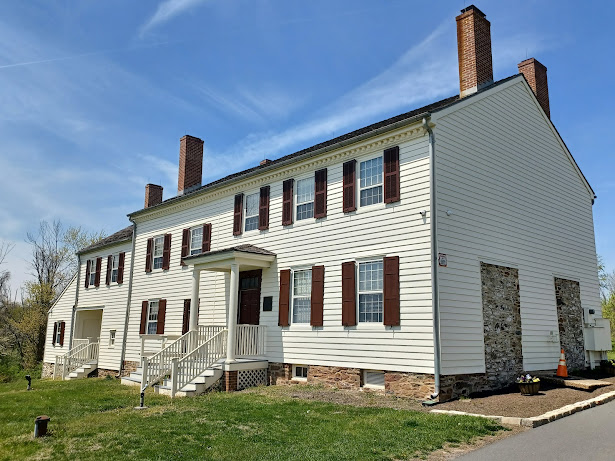
After a short bit of young woods, we came to the historic Hunt House. Now the
headquarters for the Mercer County Park Commission. The Hunt Farm was settled
before 1749, and the farm house we were approaching was built in 1762, with
additions made in the 1790s and in 1850. The home remained in the same family
until 1918.
When Mercer County acquired the property in 1969, it was allowed to deteriorate pretty badly and apparently sat vacant for a while. A study was done in 2001 to determine the feasibility of reuse, and it was found that the bones of the building were pretty good. It was decided that the house would become the headquarters building, and construction began on restoration in 2009.
We took a little break near the building at a little pavilion for a bit and did another diaper change I think, then continued on the trail route, which followed the driveway from there out to the Blackwell Road.
We crossed directly into a meadow area, and just ahead we came
upon an area that had been the subject of some controlled burn recently. The
ground still had blackened char to it.
Burn plans might burn one year and eliminate
only leaf litter, but that will grow lush, higher grasses like we see coming up
here.
In another year, it will burn "high and
hot", and the strategy can be used to eliminate highly invasive species
such as Autumn Olive.
We turned to the left and passed through more meadow, then a section of woods
before coming out parallel with Cold Soil Road.
The trail paralleled for a bit and passed by a pretty old stone house, then turned slightly to the right, further into the fields, into what used to be part of the historic Pole Farm.
19 towers, each 180 feet high, stretched nearly a
mile across the fields supported by these bases.
The towers held steel mesh curtains that were the
actual antennas, aimed to send powerful radio signals to a receiving station in
England.
The Pole Farm section of Mercer Meadows was
originally the location of the American Telephone and Telegraph (AT&T)
shortwave international telecommunication station from 1929-1975. To create
their facility, AT&T purchased several family farms, relocated the
farmhouses, and clear-cut much of the property.
Two transmitter buildings were constructed on the
southern end of the property, and the remaining fields housed the steel antenna
arrays and later, many rhombic antennas.
Pole Farm was an AT&T Bell Labs project using radio short waves to transmit telephone calls to other parts of the world. The first call was made to London in 1929.
In 1965, AT&T launched it's first satellite
capable of handling the transmissions, and ten years later the Pole Farm was
decommissioned.
These fields were grazed by a local farmer's
livestock. Farming continued on much of the property until Mercer County purchased
the land in 1998.
The main trail headed through the center, and there were some concrete bases to the left. A sign denoted some of these to be the only remains of the London Towers.
We continued to the south from here a bit, and the trail led to an open
area and parking with a lot of interpretive signage and such.
The trail weaved to the right a bit along a tree line, then went south to cross
Keefe Road.
The trail then crossed over a footbridge across Shipetauken Creek, and made its way into Village Park.
The actual trail I believe goes
along the east side of the park at this point, but there is a loop that goes
around most all of it. I forget which
way was the official one at first, but we stayed to that east side and came out
on Bergen Street where there was a sign about the ill-fated Arctic Parkway.
This highway was proposed in the 1920s as a scenic alternative route between Princeton and Trenton along present day Bergen Street, which never came to pass.
We continued away from the Lawrence-Hopewell Trail route at this point and got on Stonerise Drive. That led to a path at its end that went to Phillips Avenue.
When we got near the crossing of James Street, it was also the former crossing
of the old Johnson Trolley Line, which was the subject of many past hikes.
It was the historic trolley line that traveled between Trenton and Witherspoon Street in Princeton NJ. This was the "fast line" trolley, somewhat parallel with the older trolley line, but mostly off roads. The line opened between these towns in November of 1901, and remained in operation until November of 1940.
From Trenton to Lawrenceville, the line was then used as a freight railroad until 1974. Some sections are now trail, truncated by Interstate 95, and others are private tracts.
Still, it is worth
exploring what remains, and short road walks between private bits make for a
great long hike which can be done using public transportation from point to
point.
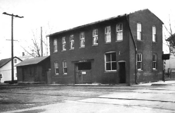
This was also the site of the Hopewell Station, and I didn’t realize until this
trip that the station building was still standing on the corner.
We followed the road right on out to Rt 206, and on the corner was TJ’s Pizza
and Pasta where we stopped for a late lunch break. I got us some slices and we
ate at a bench out front under some shade, which was a really nice stop.
The original concept for this hike as a loop meant heading to the east somewhere, and following other branches of this or other trails to the north, then cutting back to the west again around the Pole Farm. I’d done some variations of hikes like that in the past, but at this point, the amount of time and mileage we had already covered, I decided it was best that we start turning back already. There were a lot of other trails through this area I had barely touched before, and we could weave around on those enough to have it be more miles than we had covered on the way down, and that would bring me to my typical goal fifteen miles.
We made our way out of the pizza place and back up to the former
Johnson Trolley Line crossing, then turned left on it only briefly. When we
reached Craven Lane, the actual Lawrence-Hopewell Trail route, we turned right
and followed it north, back up along the other side of the Lawrenceville
elementary school.
At the end of the road, a pedestrian path section led out to a short stub of a
road, then to Bergen Street again. We weaved right and then immediately left
again to re-enter Village Park. This time, we would remain along the west side
of the park as to do something completely different.
We skirted the left side parallel with a parking area on a paved
path, and that path eventually led out to Yeger Drive to the west. We turned
off of the paved path and started following the grassy area beneath the trees,
still to the west side of the park.
A sort of new trail was across the intersection with Keefe Road, which led back into the Pole Farm property, officially now known as Mercer Meadows.
We passed a parking area and headed north back into the woods where some more infrastructure of the Pole Farm was still in existence.
We skirted a field edge after a section of woods, crossed some handsome foot
bridges, and then one very long impressive section of boardwalk around the
crossing of the Shipetauken Creek.
We took another break at a nice little bench near a trail
intersection and the spot where the boardwalk ended. Jillane was in a foul
mood, and started arguing, and then turned down the wrong trail to get back to
the start. I continued straight on the correct trajectory, and then came to another
amazing area of board walks.
For a bit, I thought I had forgotten to bring enough baby formula before finding some more.
My first inclination was that I needed to
water down the regular formula a bit to appease Ev in case he didn’t have enough.
It was getting pretty hot out and first and foremost I didn’t want to get him
dehydrated. Fortunately, he was fine and never got fussy about being too
thirsty, and never ran out of anything to drink.
We turned right at the next boardwalk trail intersection, which took us across a section of open field, and then to a viewing platform.
I had been to this site before, but the problem was I had never gone in the day light. During the time that I was transferred down to Washington’s Crossing for work, I was doing all of my night hikes down this way, and so I hit a lot of these trails in the dark, but never got around to seeing them in the light.
We went up to the platform, and the lower level was all ADA accessible so I could push Ev right up onto it. The upper level I ran up the stairs for myself and got a few views of the area.
Nearby was the historic Reed-Bryan Farm, some of which is restored within the
park. I don’t know a lot about the site, but it was quite pretty from here.
Meanwhile, Jillane was walking somewhere on the trails parallel with me. I continued straight and passed the lane that accesses the Reed-Bryan Farm, and then continued straight on the trail that remains along the field edges. This section did not have the improved surfacing that the other trails I’d been used, but it was still a nice walk with a lot of pastoral views.
Somehow, I stopped looking at my phone for only a short period of time, and I had made a wrong turn. I ended up back over on the east side of the Pole Farm again because the trails didn’t all have great markers along the way.
In doing so, I ended up back at the Hunt House. At least from there, I knew
what I could do to continue on. I figured this would end up buying Jillane some
time to catch up with where we were. She had google maps on her phone, so she
should be fine.
After a little ways down and across Blackwell Road, just before
the Hunt House, I made a left turn which took us rather steeply up a trail that
followed a utility clearing. This took a little wind out of me but I needed the
exercise.
Once to the top, and a little ways down, there was another trail to the right
that led into the woods. The unimproved trail led to a good crushed stone trail
continuing to the north. This was the original route of the Lawrence-Hopewell
Trail, and the route it used the last time I had hiked through. That would
explain why the surfacing was done on that section. It brought me back to the
main Lawrence-Hopewell Trail, and we turned left to descend and cross the dam
at Rosedale Lake again. There were still a lot of people around that park when
we passed through.
We went by the pavilion, then made the hard right to bring us over the very long foot bridge over the Stony Brook.
We crossed and turned left, then continued through the same area
we had gone through in the morning, over the nice board walks, out to Old Mill
Road, then across fields to Pennington-Rocky Hill Road.
We turned left, to the south, onto the spur trail route and crossed
the Stony Brook, then turned right on King George Road to reach Jillane’s car
parked above the Stony Brook.
Jillane was not there yet, and I figured she would be somewhat shortly, so I
took Ev out of the stroller and we went down to play in the Stony Brook, at a
very nice spot.
After a bit, she texted that she was not so close, and I asked her if she
wanted me to come and pick her up. She said yes, and so I brought Ev back up to
her car. She said she was at some historic farm somewhere. I assumed it would
be the Reed-Bryan Farm.
Sure enough, that’s where she was, exactly two miles away by quickest route.
I strapped Ev in and we went out there to find her. The sun was starting to go down, and there were a couple of women there doing some sort of Yoga. I put Ev back in his stroller, and we walked a little bit more around the area where Jillane was checking out old trees and possibly old farm dumps.
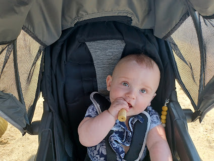
I’d had a really fantastic day pushing Ev around, despite the weird altercations. Ev seemed to really enjoy this one more than the usual, and I couldn’t wait to spend more of the Spring experiencing these places with him.


No comments:
Post a Comment