

Hike #1570: 9/17/23 Rock Mill Preserve to Rocky Hill with Jenny Tull, Professor John DiFiore, Serious Sean Dougherty, Justin Gurbisz, Shayna Michaels, Galya, Ric Giantisco, Lyz Hagenbuch, Evan "Joe Millionaire" Van Rossum, Diane Reider, Violet Chen, Sam Chen, Kamila ?, Jenn ?, and Everen
This next hike would be a point to point back in Central New Jersey. It does not coincide with Governor Phil Murphy's asserting that Central Jersey is officially a "region". I see that as just more pandering craziness from him to be completely honest.

Central Jersey does have a sort of identity, but when it comes to declaring certain regions, it is hard to take a small place like New Jersey and to draw a line. As a moderator for several different social media groups, of which some of the most popular are the "Things That Aren't There Any More", northern and southern NJ editions, I find it easiest to draw the line right about where Rt 1 crosses from Trenton up to the Arthur Kill area. There are certain exceptions, such as parts of Monmouth County like Sandy Hook where you can see New York City. There are certain people who live further south who will refer to Princeton as North Jersey. That's all fine, and I don't need to make any rules about it.

However, when it comes to "regions" as government is concerned, New Jersey was already responsibly set apart into Tourism Councils.

I've grown up in the Skylands; not quite just the Highlands, which is the geological province, but also not urban east Jersey, the Skylands encompasses Warren, Sussex, Morris, Hunterdon, and Somerset Counties. It seems appropriate.
Similarly, Monmouth, Middlesex, Essex, Hudson, Bergen, and Passaic are known as the "Gateway" counties. This seems appropriate because they are the route most any artery from the city enters. It includes Gateway National Recreation Area.
Truthfully, the only place I could really see being labeled "Central Jersey" would be Mercer County, and maybe Middlesex. The other areas, which include some of Hunterdon, just sort of confuse things.

That being said, the area we were hiking was very much the central part of the state. It would be mostly in Somerset, some Mercer. Much of Somerset is certainly the central part of the state, but the county extends so far north and even into some of the Highlands, that it shouldn't be set apart as a region.

There are some really great trails that connect all around Princeton, and that town has been ahead of the game for decades. Now, the neighboring municipalities are catching up. I've done a lot down there, but there is still a ton to do.

I was covering a lot of that stuff on night hikes in the past, but at this point, not doing night hikes, I feel like there has been a deficit of hikes in that area, so it was time to go back.
I found a whole lot of stuff I wanted to do between the Kingston area, north of Princeton, and the Sourlands Mountains, and so I planned it around this.
Often, I plan a hike based on where the middle parts would be, and then figure out either end by tacking miles on there. This time, because it was so easy to put together anything really, I decided to just pick a start point and figure on the right distance from there.

In this case, I was initially looking at the Sourlands Mountain Preserve of Somerset County, but then I noticed a preserve I'd not seen before. This was the Rock Mill Preserve, at the foothills of the Sourlands. I came up with a route that would take us from there to Kingston, and then up to Rocky Hill, featuring many different park lands.

We met at the Rocky Hill trailhead on Kingston-Rocky Hill Road, and shuttled with as few cars as we could north to the somewhat new Rock Mill Preserve, which is located in Montgomery Township on Grandview Road.
We got a bit separated in the shuttle, but everyone showed up pretty quickly. A woman and her child were walking there, and looked rather surprised to see so many people show up at this obscure preserve area.
I announced to everyone that we would not need to bring our packs or anything at the start. We could simply walk the little loop out of this lot and come back in under a mile, then grab our stuff.

There was no way of making this part of a through route, so it was just a nice little thing to add on at the start.
The trail was well worn, and often lined with sticks and such. Some rocks were laid out over occasionally wet spots, and on the west end of the preserve, there plantings of new young trees by Sourlands Conservancy I think it was. I don't know what species they were, but they struck me as being too close together. I can't judge much not knowing what they are.
As we made our way around to the west side, we got close to the Rock Brook. I know this brook was used for some minor milling in the past, but I could not find anything of such on the historic atlas maps of the area, of which there is one from 1873 online.

Just a bit to the south, there was a stone wall, built in vertical fashion, which does not look like other area stone rows.

I assume this might have been part of an old mill of sorts, maybe a saw mill. A channel of the Rock Brook beside the trail was dry, but looked like it may have been artificially channeled out for use of the water in milling.
We continued around to close in the loop, and paused when we got to an area where deer exclosures were set around trees and areas of the woods. I pointed out to everyone how the understory within the fences was doing far better than on the outside, because of the overpopulated deer over-browse.

We headed out to the lot again from this point to the parking area and got our stuff together. I was going to let Ev keep walking from here, but then realized the road was pretty narrow and I need him to be safe.

I put Ev in the stroller, and he didn't protest too much since he just got to walk a bit loop, and was still getting a lot of attention despite being in the stroller.
This one was great because Lyz, Ric, Galya, and Shayna were all there, had hiked so many miles with me, but had never met my son before. As expected, they all got along with him wonderfully.
We made our way down Grandview Road, and crossed Rock Brook. The water level was pretty low, but it was pretty.

We turned to the left on Hollow Road briefly, and then almost immediatley right on Servis Road. I'm not sure where this name came from, but it was a nice and small road that went gradually uphill, and was very narrow. It was just perfect for walking. I immediately let Ev back out of the stroller asking him if he wanted to run again. He immediately started running much to everyone's amusement.

We continued to the top of the hill, and then descended the other quite easily.

We emerged at the bottom of the hill on Hollow Road again, and I put Ev back in the stroller to ride some more. A short distance down Hollow Road, there was an old building on the right that used to be a small school house.
Just a little further than here, we turned to the left on Camp Meeting Ave. We crossed the Rock Brook again, and then turned to the right into our second park, Bessie Grover Park.
This little park is basically just a tiny picnic park with no real trails through it, but it does have a portable toilet, trash cans, and a really good playground.

I changed Ev's diaper, which was definitely needed, and then let him run and climb on the playground. There was a ladder up the one side of it, which he climbed really well the first time, but slow, and then he proceeded to come down and climb it over and over again.

Everyone else jumped all over the playgrounds at the same time, and so Ev was not alone in his climbing. Every time he came back around for the ladder, either Violet or Ric was there to spot him if I wasn't. There was a slide that had rollers to it, and although he wouldn't go down the regular slide (his fear of these goes away and comes back), he kept doing the roller slide over and over.
After this good shady break, we continued on the road to the east, which changed names to Skillman Road ahead. It soon crossed over the active railroad tracks on a bridge.


This was the former Delaware and Bound Brook Railroad built in 1876, which became a main line of the Philadelphia and Reading system. It was the line that put the nearby Mercer and Somerset Railroad out of business in 1880. Today, it is operated by CSX.

I waited on the one lane bridge a few moments with hopes that a train would go by for Ev to see. It is used pretty frequently, but nothing came by and there was no walkway and too many cars.
We came down from the bridge, continued ahead, and then turned to the right when we came to the entrance to the Montgomery High School. This area seemed to be a public common area more than other schools, and perfect to get us off of the road for a bit before getting to Skillman Park.
We were on the north entrance road only briefly, and then turned to the right through the grass, and around the Couger Stadium.
The area around it was mowed until a point, and then became heavy grass. I was still able to push Ev though it in the stroller without a problem. I thought to maybe let him out at this point, but I also knew we were going to be going into the Skillman Park which has a lot of roads going through it, and it'd be better to let him out when we were clear of some of that.

The heavy grass ended at the west side of the stadium, and it was nice and mowed as we continued walking to the south through the property.

We stayed on the grass around the stadium and then some tennis courts, beyond which there was a bit of paved trail along the side of a baseball field. That ended, and we continued through the grass. We turned to the east at the south side of the high school property, and then came to another paved trail adjacent to the second baseball field.

Just to the south of the school property, there was a large barn, which looked as though it might have once been converted as living space. It even had a skylight on it, which I doubt they would have installed for just cows or other farm animals.

It is my understanding that this, which had state land, no trespassing signs, was part of the Skillman Village we were about to enter. I think even where the high school is now was once part of it, just not the main part.
Just after the barn building, also on the private state land (an access road known as Cedar Lodge Road, probably Skillman Village building), there was a large yellow abandoned house.
The building was in surprisingly good condition. The roof looked fine, and the windows didn't appear to be broken really.

Where the house stands is either right on or directly next to where the Mercer and Somerset Railroad used to go.

I think some of it was on the Cedar Lodge Road. The Pennsylvania Railroad funded this project, which would have been a through route, built rather haphazardly to try to block the National Railroad from going through. It was completed in 1874, but the National Railroad materialized as the Delaware and Bound Brook, and was build to higher standard. It could not compete.
I had tried to give a history talk on the Delaware and Bound Brook while we were out there, and half the group just kept walking ahead with no interest, so I stopped on that one. I meant to bring up the Mercer and Somerset, but then I forgot as we were going by. Violet remembered, but figured I decided not to say anything about it.

The paved trail turned to the left, north, and headed up to the solar panels that are over the parking lot and access road. We walked under it for a moment, and then followed the access road sidewalk out of the high school area, to the edge of Rt 601, Belle Mead-Blawenburg Road.

A paved path went right and then crossed over the road to the left, and entered Skillman Park adjacent to one of the access roads heading east.
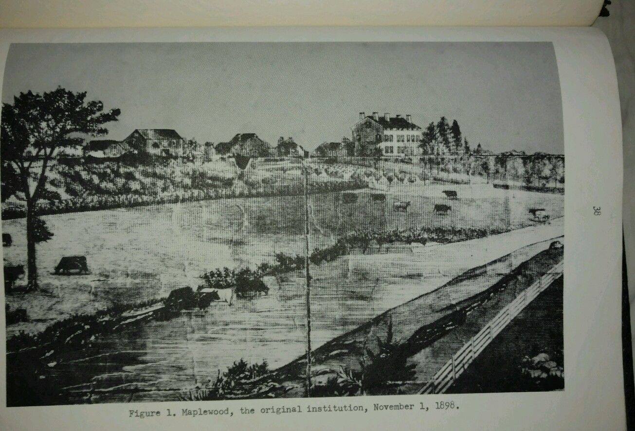
This area was originally six large farms. They were purchased in 1898 by the state of New Jersey to create the “New Jersey State Village for Epileptics”.
It was one of the first facilities of this kind in the United States; a completely self-contained village for the disease which at the time had no known treatment. There were residences, a power plant, hospital, farm school, maintenance area, theater, water treatment, cemetery, and land fill. The entire thing was sewn together with lovely landscapes designed by Charles W. Leavitt in 1901.

Focus shifted in in 1952 and it became the New Jersey Neuropsychiatric Institute. Then, from 1975 until 1998, it was the North Princeton Developmental Center, a Human Services facility.

Things changed in the 2000s. There were over one hundred buildings in the village, which were now falling apart and neglected. Like so many other places, studies were done on creative reuses for the property, but most of the buildings ended up torn down anyway.
The few buildings that remained and were thought to have a future ended up demolished by 2011 as well. As is to be expected, the Maplewood Cottage, possibly the oldest and nicest of the buildings on the property, burned down suspiciously in the fall of 2011.

The property is now just a passive recreation park that retains much of the original landscape design, but all of the buildings are gone.

I paused the group up near the central circle area where the main administration building would have been in the center, to let them know what it was all about.
In my earlier days of urban exploring, I'd been in a lot of places, but Skillman seemed to escape me somehow. I remember reading about it quite a lot in the Weird New Jersey forums on Yuku, and then people started getting busted there. I figured one day I'd get to going through it, but then it was all of a sudden too late.
Even Justin, who has been in just about everywhere, somehow never managed to get into Skillman, and yet we were both very much aware of its existence before it was gone.

I had some historic photos of the site, of a couple of the buildings around the outside, but I amazingly could find no historic photos of the large administration building itself.

I find it rather hard to believe that almost nothing of these buildings is found online anywhere. The only stuff I seem able to find is the stuff I'd posted on Metrotrails in the past: images of three buildings. Everything else is recent urban exploring photos from recent years, after abandonment.
On the far side of the main circle, there were people unloading stuff, I think for a 5K run thing. Half the group wanted to go over and crash it, but I kind of wanted to leave them alone.

I was also trying to figure out where two of my historic images were taken, and I think I narrowed it down to one of two buildings on the southeast side of the circle, but I had a hard time trying to get the shot right. I need to review an historic map of it to figure it all out. I didn't have the time to be stressing over things that exact at this point.

We cut to the right from the circle, off into grass, and then to a paved trail on the south side of the property. This was shown as Lake Drive on the maps. The Rock Brook goes through the property, and Sylvan Lake used to be on the south side. It still holds some water, but it looks as though the lake itself was purged and turned into a wetland restoration project of sorts.
I definitely need to explore the property more. There are many mowed trails that go along the south side of the property, and the fact that six farms were once here, some more might be preserved than I'm realizing.

We skipped a nature trail turn, remained on the pavement a bit longer, turned right on another former road called Maplewood Drive, and then turned right on a mowed trail to the east just after the turn off for Greenhouse Drive.

We emerged from this mowed trail on another old paved road called Doctor's Row. This was not used as part of the trail system, and had grasses and such growing through the pavement.
We turned to the right on this, downhill gradually, and came out to Burnt Hill Road.
Once at the public road, we turned left briefly, and then right, and crossed over the Rock Brook Bridge, which is a 5 panel, bolt connected, Parker pony truss bridge that used to be on Burnt Hill Road, but was taken out I think in the 1990s, and then re-erected at its present spot as a greenway connector.

The municipal sites seem to claim that it may be the only Parker pony truss in the State of New Jersey, but this is false, because the Carnegie Truss on the Taylor Steelworkers Historic Greenway in High Bridge is the same design.

There was a green acres sign at the entrance, but no trail markers. This property ahead is quite obscure as far as open space goes, and Google Maps simply labels the public land as "Dale".
Once across the bridge, there was a steep trail that just went up a clearing, which appears to be a utility clearing, but with nothing on it. It was kind of steep, but Sean, once he'd finished walking across the top of the Parker truss, ran over and helped me pull Ev in the stroller up the hill.
Once we got to the top, a mowed trail continued around the edge of the fields to the left.

I had walked some of this once before, but as a night hike, and I did this section as well as Skillman Park in the dark. The park was easy, but I remember being through high grass in this section in cold weather. This time, there was an obvious perimeter path around the fields.

I figured this would be a good spot to break out something good Sean showed up with: some Jersey Cyclone Brewery's "Thunder in the Distance", a barrel aged barleywine style ale in a big bottle.

This one had one of those weird wax coverings around the top of it, which I guess keeps it more fresh. I forgot my bottle opener, and usually I use a sign or something to open it, but I didn't have anything.
Fortunately, Kamila had one handy, and we partook of the good stuff immediately.
This barleywine was absolutely excellent. An excellent choice.
This was right on time for the next little surprise. We reached the edge of the field, turned to the south, and then through an opening to the left, we came upon a sprawling cemetery, which at first looked to be military because the stones were all the same.

We then saw the sign, which noted this to be the cemetery associated with Skillman. A sign at the entrance gave the three names the site went under, and the years it was active under those names.

The cemetery was kept in surprisingly good repair for something that is no longer in use. It seems to be regularly mowed down, although not at lawn length.
We paused for a break here, in good shade, with some lovely large trees along the south side.
Once we were done with our break, we continued along the trail, which shifted along the fields to the west, and then to the south again. Eventually, it emerged onto the Georgetown-Franklin Turnpike.

Here, we turned right only briefly, and then left on Cherry Hill Road.

As we walked the road, I missed a turn off to the right. We could have eliminated some of the road walk because the trail goes farther than I realized, through the Waldorf School of Princeton property. At the turnpike, we left Somerset and entered Mercer County, which is probably the reason the trail systems are not more formally connected.
Whatever the case, we just headed down the road until we got to the point where the trail crossed the road. To the left, it entered the system of trails in the Cherry Brook Preserve.

This next section was nice and easy again. I let Ev back out of the stroller here, and he took off happily on the trail.

We were first in a successional woods of Eastern Red Cedar, which provided a bit of shade. There were some mowed side trails that did not appear on the Google maps, but when I checked it later to the ones on the NJ Trails Association site, it showed lots of them.
I had to watch for where each of these trails broke off to be sure we were going the right way.
We passed from the cedar into a nice, laid out plantation of Norway Spruce ahead, which was kind of neat compared to the rest of the stuff we had gone through.

We got to a point where two very prominent trails came together, and we had to hold up to make sure everyone was going the right way. Ev was further in the back with John at this point.

The trails were wide, but narrow enough that we couldn't see everyone all together. The second time we re-convened at a trail intersection, Ev was picking at his butt which meant he needed a diaper change again, and it was a major yuck disaster.
I had to take some time to find a good bag in the pack to carry the mess out in, and fortunately I did come prepared for that this time.
Once we were on the move again, he was feeling much happier, but he was also burning out from all of the walking. Once again, he allowed himself to be put in the stroller with far less protest again.

We exited the young transitioning forest and entered a field. We took the trail that remained to the north side of it, which then shifted to the west. At the south end of the field, there was a trail to the left, which we should have taken, but I remained on the edge.

By the time my phone GPS caught up, I realized we went a bit too far, and we had to turn around. We took a path through a line of trees, and emerged on the edge of a retention pond, where we turned left to go north. Soon, we passed the entrance from the other trail we should have taken.
We continued along the edge of the retention basin, continued behind some homes, and then emerged at the end of Linton Drive. From there, there was a paved pathway that paralleled the road ahead.
We continued on the road out to Cherry Valley Road where we crossed and turned left. A paved pathway followed the road for a bit, but we turned in to a townhouse complex along the road sooner, to follow the development walkways to the east.

We continued east from Griggs Drive between the buildings, and emerged onto Billie Ellis Lane. The group made some comments about singer Billie Ellish or something I think at this point.

We turned left briefly, backout to Cherry Valley Road, and turned right. We continued on this, and my intent was to turn right when close to Herrontown Road.
The group asked to go just a little further ahead to an Exxon station or something where there was snacks, so we went over that way first and took a little break. It was only a short distance away, and we made our way back to the southwest again, along intersecting Rt 206, and then headed east on on Herrontown Road, which had another good paved path along the right side.

At the intersection with Mt Lucas Road, Herrontown Road used to continue straight, and is now abandoned. I had followed this route once before on a past hike, but it'd been a while.

We headed uphill gradually on the old road, and I pushed Ev up it in the stroller. When we got to the top of the hill, Bunn Road went right, Herrontown Road continued straight, both open to vehicles again, and the Stone Hill Church of Princeton was in the corner between the two.
We turned to the right, into the parking lot for the church, and walked the sidewalks around the outside of the building to the far corner. In that area, there was a trail access into Herrontown Woods Preserve.

This was Princeton's first preserve, donated by internationally renowned mathematician Professor Oswald Veblen, of the Institute for Advanced Study, in 1957. The preserve expanded including the final fourteen acres surrounding and including the Veblen House and Douer Farm Cottage.

As soon as we got out of the connector trail from the church and onto the main trail, it was lined with rocks to keep folks out of water in wet conditions. it made it tough for the stroller, but not too terrible.
We meandered through the woods until eventally we came to the Douer Farm Cottage.
This building dates back to before the Veblens occupied the property. It was built as a farm cottage about 1875, and when the Veblens took it over, it served as an adjacent study in the wilderness.

It is said that Albert Einstien, on his walks about Princeton, would stop in at the house and have a sandwich while he was passing through.

The Veblens started acquiring the properties in the area around their home and their cottage around 1930.
The one out building at the cottage was open, and inside was a ping pong table. Also in here, there was a skeleton of an animal for display.
We continued from here down toward the main entrance to the preserve. Violet told us which way we'd need to go to the actual Veblen House, but I decided that would have to be for another time. There was just too much more to see, and I didn't want to put us too far out of the way.

We continued through the woods, and there were more of those stones that would be in the trail that inhibit erosion and allow for dry footing.

Pretty soon, we reached the parking lot for the preserve, which took us through the preserve.
This was unlike anything I remembered from before. The entire entrance of the park had been upgraded to a sort of art garden, known as the "Botanical Art Garden", or the "Barden" for short.
As the story goes the way I read it, things were looking pretty bad because some major storm damaged at the entrance area to the park due to stomrs. As a part of cleaning up the mess, as well as removing invasive species and such, the Barden was created. They did a pretty amazing job.

We all sat for a break at the entrance, and Violet encouraged me to check out some more of it, so Ev and I started meandering one of the little loops through.

There were little buildings, an awning with a grandfather clock, sections of logs to walk across in addition to bridges, wooden art installations, chairs, and more.
After we were just about ready to leave, a guy came up to us to chat a bit. He said he was working on the trail system there, and was curious where we were coming from and going to.
I gave him my contact info, and he seemed pretty cool. I told him I'd be glad to come back through and organize another hike through the area when they have their new trail open to promote. I have probably another almost completely different version of the same hike we'd just done, with some of the different trails, that would be quite worth coming back for.

We continued out the access drive to Snowden Lane, and continued straight across into Barbara Smoyer Park.

I made a mistake in the area just ahead. Paved trails lead through the park to the east, then northeast, out to Herrontown Road past a pretty little pond with an aerator fountain.
I went that way, but I had intended that we would go along a southern route and come out on Terhune Road, then follow that a few blocks to enter the Gulick Preserve at the end. That would give us a bit less road walking on the way out to the Kingston Bridge.
It was no terribly big deal that I missed the turn. We continued along Herrontown Road to the east instead, and we did turn right into a corner of the preserve before making our way out to River Road. We just followed the bit of it over to that, and then turned to the right, to head south.

Pretty soon, we crossed and passed through the parking lot of the Princeton Church of Christ, and then reached the intersection with Rt 27, Princeton-Kingston Road.
We crossed over, and then a set of steps led downhill to the old stone bridge over the Millstone River, which sits adjacent to the old mill and later highway bridge.
Everyone stopped for a break on the bridge, which had a great view upstream of the old mill dam, and the Carnegie Lake dam just a little further upstream. It was running surprisingly dry this time. The last time I was at this spot, a lot of water was flowing over both dams.

The first mill in Kingston was constructed in 1755, and burned by the British army in 1776. It was rebuilt, and replaced in 1888 with the handsome old mill that still stands on the north side of the bridge today. The road is now cut off at that point, and a staircase (which we used) brings walkers up to or down from Route 27.

The 1787 bridge replaced the original also burned by the British army. It has a stone tablet in the middle of it with the date of construction, and the miles to Philadelphia and New York.
Lake Carnegie, built in 1906, was a gift to Princeton University by Philanthropist Andrew Carnegie.
Prior to the construction of the lake, the Princeton Varsity Rowing team rowed in the still busy Delaware and Raritan Canal, which was far too narrow for the purpose. While sitting for a painting by 1876 Princeton grad Howard Russel Butler, Carnegie was related the story of Princeton’s needs. Carnegie, who had constructed many lochs in his homeland of Scotland, took interest in the project and asked Butler to look into it.

Butler complied and came up with an estimate of $118,000. Starting in 1903, a group of Princeton alumni began purchasing land of local farmers in what would become the bed of the proposed lake. They would then sell the properties to Carnegie.

Having the alumni purchase the land was done as a strategy to avoid arousing suspicion in local residents, as well as to get Carnegie the properties at the lowest possible prices.

Woodrow Wilson, President of Princeton University at the time of the lake’s completion, tried to secure a second grant from Carnegie, who responded “I already gave you a lake!”.
Carnegie, while generous, would not allow himself to be taken advantage of.
I took the opportunity to climb down to the bottom of the bridge, walk underneath, and lay in the water for a few moments. I was terribly hot, and thought I'd have the chance to lay down in the Rock Brook much earlier on, but it was never really deep enough for any of that.
I came back up, and we walked east off of the old Kingston Bridge.

Just to the east, we came within good view of Lock 8 on the Delaware and Raritan Canal, known as the Kingston Lock. This was built as part of the main canal in 1832 and remained in service for a century.
Once we were on the other side of the lock, the rails were still visible in place on the former Rocky Hill spur of the Pennsylvania Railroad.
The branch was constructed from Kingston to Rocky Hill in 1864. A terra cotta factory was constructed at that town three miles away, which could be served by both the D&R Canal and the railroad.

In it’s heyday, a train could be taken from Rocky Hill to Kingston, and then on to Monmouth Junction.
The original connection was as a spur off of the Camden and Amboy Railroad. There was a branch of that line between Trenton and Monmouth Junction area that was built in 1839 to better serve the areas around the Delaware and Raritan Canal, Princeton, and Trenton. It didn't do so great, in part because it followed the berm side of the canal, and was subject to a lot of swampy conditions and needed a lot of repair.
 |
| A scene on the Rocky Hill Branch at Rocky Hill Station |
When that branch of Camden and Amboy was abandoned (and led to the creation of the Princeton Dinky) in 1865, the section from Monmouth Junction to Kingston was retained to access the Rocky Hill Branch.
Passenger service ended however in in 1929, the same year the terracotta factory closed.
The line served freight from the Rocky Hill quarry until Conrail abandoned it in 1983. It now serves as part of a loop trail used with the canal towpath between Kingston and Rocky Hill, and provides access on the opposite side of the canal to the former Camden and Amboy Junction, and trails through Princeton Nurseries properties.

We crossed the road and continued walking along the old Rocky Hill Branch to the north. It really wasn't very long at all from this point until we got back to the parking lot, and Ev walked most of the way himself.
When we reached the end, some of us decided we would have some dinner at the Rocky Hill Tavern, which was quite splendid. I was pretty hungry, and feeling a bit out of it. Ev loved the burger we ordered and of course had a lot of fries, which he loves.
I think he's getting better about sitting down for dinner with time, which is great. He sat in a regular chair instead of a booster this time and did pretty well, although he ran into the main room of the placed and moved chairs just a bit.
Sean summed it up pretty well over dinner, that it wasn't a crazy party hike, but it was a pretty good party of a hike. It was kind of mellow, but also diverse and a lot of fun. I think it was definitely the right one to schedule for this weekend.f
Sean, Ev, and I stayed in the parking lot for a bit after, and discussed what we should post the following week, and before we left, we agreed that Staten Island would be the best choice, because there was so much more there to do, and it'd been a while since we revisited and tried to do some of the parks we left off with.
No comments:
Post a Comment