

Hike #1563; 7/30/23 High Falls to New Paltz with Matthew Davis, Robin Deitz, Steve Sanbeg, Heshi, Diane Reider, Stephen Argentina, Karen Lee, ?, and Everen
This hike would be the second to last one in our Delaware and Hudson hike series, which has brought us from the gravity railroad in the Lackawanna Valley of Pennsylvania all the way to High Falls.

I planned for a short portion of the canal from High Falls to Rosendale NY to be the first bit of the hike, and then we would follow the Wallkill Valley Railroad to the south, which would also make this part of our Empire State Trail series, which we hadn't revisited since we did completed the Maybrook line a while back.
Unfortunately, Russ Nelson did not make it out for this one, only two from the end, which meant I was the sole remaining person who had done all of the D&H series hikes, with only two remaining.

I planned for the hike to meet in New Paltz at the New Paltz Plaza, and we'd shuttle north to High Falls to begin the hike. I also threw a couple of other things into the mix with this one which we hadn't done before, to make it a bit more interesting.

Once we had everyone together, we shuttled with just two cars to High Falls where we met up with Bill Merchant for the start.
We had just done his "Five Lock Walk" through High Falls on the previous hike, which is soon to become six locks, because they were closing on the piece of property that includes Lock 16 as well as the telegraph office.
I got Ev together in his stroller at the start, and we soon crossed over Rt 213 to explore the canal toward the High Falls Aqueduct.


This route we were following was the 1850 re-alignment of the canal. The original 1827 aqueduct was a stone arch structure that sat just upstream of the John Roebling cable structure.

The two diverged just below Lock 16 and the Depue Canal House, which served as a lock tender's house for several year. Mr. Merchant brought up that the white house across the street from the Depue Canal house is known as the "lock tender's cottage", but it nevers erved as such. It was a sort of quarry company's office, never a lock house.
Depue Canal House was a lock house, but it was not built as such. Its history actually dates back to before the canal.

The Depuy Canal House actually predates the canal, having been built in 1797 on the major trade route to Kingston NY, believed to once have been part of Old Mine Road.

The Delaware and Hudson Canal was constructed in 1828 between Kingston and Honesdale PA, and originally passed along the north end of the building.
When John Roebling completed the High Falls suspension aqueduct to replace the original stone arch aqueduct in 1850, the canal was significantly rerouted, and it passed along the east side of the Depuy House.
Directly adjacent to the house is the well preserved Lock #16, which raised or lowered boats 12.66 feet. The flight of six 1850 locks at High Falls are composed of fine cut stone rather than the composite wood lined design of most of the D&H Canal locks.
We got on the towpath to the right of the canal; there were actually towpaths on both sides of the canal for the High Falls Flight, for convenience of traffic of boats here.
Lock 16 only has some of the fine cut masonry remaining at the upper end. All of the rest of it was removed and re-used somewhere else. I don't recall if we know exactly where those blocks ended up.

Lock 16 had a lift of 12.66 feet.

The telagraph office was tarped and being worked on as part of the new exhibit as well. Money is needed to really pull it together, but with Mr. Merchant at the help of these projects, they might just succeed. He's working on trying to get the site recognized as a national historic site, which might make them eligible for more funds.
We continued down from Lock 16, and there were abutments, which were quite high, where a towpath bridge was for mules to cross between the two towpaths. The original canal route diverges to the left, and was used to some degree after abandoned for navigation as well.

We crossed over a spillway in the canal, or maybe waste weir. I had Ev out of the stroller and walking here, but had to stick close to him because I didn't want him to get clumsy and fall off. He's pretty sure-footed, but when I know he's tired I have to watch him.

This weir area was also grown in pretty well, and so I didn't want him to wade into weeds that didn't have footing below.
Ahead, we approached the former west end of the Rondout Aqueduct, one of four cable suspension aqueducts designed by Roebling on the canal (the others included the Neversink, the Lackawaxen, and the Delaware which is still standing).
We went through a very interesting and in depth dissertation on this, and Steve helped me with Ev, because he kept pulling away from the group to explore every which way.


This aqueduct was destroyed by fire around 1913, but the original stone aqueduct from 1827 survived until the 1950s when it was dyanamited away due to some bunk claim that it would inhibit water flow during times of flood.

The canal was abandoned in 1899, but below High Falls remained in use some years later for the industrial cement uses along the way.
We made our way to the left and down to the older canal route, where we checked out an old office building foundation, and then the stone lined lead-in to old Lock 15 on the original canal alignment. We could see the lower wing wall remnants to some degree where a gravel road is built over the end of the lock. It is an obviously narrowing part making us pretty certain this was the lock site. Above the gravel road, there is also what might be the remains of an old gate pocket still standing.

From here, Mr. Merchant was going to depart from us, and then meet up with us again later at the Century House on the former Snyder Estate.

The rest of us turned to the left on Rt 213, then left again on Bruceville Road.
The road was quite pleasant, and had barely any traffic, so it was a good walk. On the left, we almost immediately passed the old blacksmith shop.
This was the shop of Silas M. Niles, built in the late 1800s.
We continued on down the road, which brought us to a great outlook point with lots of rocks along the Rondout Creek.

I didn't realize it at the time, but it was from this road that several of the historic photos of the High Falls aqueducts were taken. I was able to pull these photos up on my phone, and get some modern versions of them that I was quite happy to get.
I had figured I'd need to be standing in the middle of the stream to ever get them, but this was perfect.
We continued down the road, uphill a bit, and through some good shade. We had some drinks and just really enjoyed the walk.
 |
| Probably old lock 15, buried |
We unfortunatley missed a large section of the canal on this road stretch. It is one of the longest sections of the canal we had to walk parallel road for due to private property.

We were actually pretty high above the canal at this point, so we couldn't even see it.
On the last trip, we visited locks 13 and 14, and came very close to 12 to where we could at least seen the lock house. Those were the locks known as the "N***er Locks", because there were black families who were lock tenders in this area, probably shoved out of the way from High Falls due to prejudice. They were some of the very secluded locks. The N word name of these locks were left out of the guide book, while most other locks are referred to as their historic names in addition to their numbers.

The guide book by David Barber refers to an old railroad bridge over the Rondout Creek and coming probably form the New York, Ontario, and Western line from the north, but Mr. Merchant insists that this was not a railroad and there was never a spur that came off of that line.

It must have been something else, like a road bridge or a tram of some other kind. I checked the aerial images and the lidar of the area myself, and it does look unlikely that a railroad would have made such a big drop in elevation there. I also could not find a railroad on any of the historic USGS maps of the area either.
The next lock we missed while on this slope on the other side of the creek was Lock 11, also known as Cole's Basin lock. The lock had a lift of 10 feet, and is in a secluded area along the Rondout. There are also ruins of a lock house there, with masonry fireplace in the basement level.

It was in that area of the canal that the Cottekill Brook flowed down to the Rondout, and there was apparently a basin, as well as a dry dock on the downstream side between these locks.

Less than a half mile east of Lock 11 was Lock 10, known as Humphrey's Lock, which had a lift of ten feet. Coles Basin was between these two locks.
It would be a rough bushwhack I'm sure, but I hope to one day be able to visit these locks. This area is not like some of the areas farther to the west in Pennsylvania where we were able to just bully on through. The people on this end are richer, and probably more likely to press charges if we were caught on their lands.
At the height of the land on Bruceville Road, there was a high land berm we passed between, which I wondered if it could have been a railroad bed associated with the abutments we never got to see, but it looked unlikely. It was definitely a natural formation.


We continued downhill from the top, and reached Rt 213 again below. We turned left, and soon crossed over the Rondout Creek on the road bridge with pretty views.

A little side road to the right on the east side of the bridge had a parking access to the Rondout, which I saw as an opportunity to get in the water. We went down to the parking lot, and I was blown away to find that there was absolutely no path down to the stream at all. It really struck me that people are becoming terribly lazy and not taking advantage of what could be such a great river access.
I was in no mood to bully on through to get to the water here, so we headed back up and started following 213 to the east.


We could see where the canal used to cross, into the private land that keeps us from going through the next section to the west of us. They have plenty of signs and large fences keeping people out.

To the east, the canal is immediately below Rt 213, so we needed only to follow along that for a bit.

Pretty soon, there was a side road to the right that went down to the Snyder Activity Fields area. The main public access to it was a little further to the east, but we went down the first one, crossed over the former canal, and then passed through grass along the edges of the sports fields to the main access road.
Mr. Merchant drove by us just before we reached that turn off and came back looking for us. While we were down in the Snyder fields, we saw him walking above.
The fields had a mowed lane going east for a bit, which we tried to follow in case it was a new trail they'd put in, but it turned out to be nothing but a dead end to a vegatative dump area.

We headed back up the road, across the old canal, and then turned right on 213 again. Mr. Merchant told us that the canal there was in public ownership, but just not cleared. It also goes into private land just ahead, so it might not be worth it to go on with clearing it for such a short stretch.

We continued along the road for a bit more, into the little settlement of Lawrenceville. We found a box of kids toys out for free in front of one of these houses and gave Ev a weird blue ball we found there. He kept throwing it out into the road, so we couldn't let him have it because it turned into a game we didn't want to deal with in traffic.
Ahead, the road got ridiculously narrow, so Mr. Merchant took us up a side road to the left, past some private homes, which brought us to the Century House at the former Snyder Estate, part of the major Rosendale mining operation.

To fully understand the scope of what we were exploring, one must understand the scope of cement mining in the region.

When the Erie Canal was being dug upstate, Engineer Canvass White discovered a way of making natural hydraulic cement using the limestone and dolomite. The similar process was found, some believe by engineer James McEntee when the Delaware and Hudson Canal was being built, around 1825.
The Snyder family got involved in the cement mining business, and the Century House was built by Christopher and Deborah Snyder for newlywed Jacob Low Snyder in 1809.

In 1825, Snyder ceded some of his land to John B. Jervis for the Delaware and Hudson Canal to pass through. As a condition to this, Snyder required of the canal company that they construct a slip from the canal from which he could ship his produce to market directly from his property, and a bridge to connect to his mill.

When the area for the slip was being excavated, it was discovered that a large amount of dolomitic limestone of high quality, which could be pulverized and used as cement without additives, was on the property.

Snyder leased the southeast portion of his property to Watson Lawrence, who had already built a cement facility just to the east. That area grew up to become Lawrenceville with this industry.
Popularity grew, to the point where all natural limestone cement became known as Rosendale Cement.
The cement was used on such huge projects as the footings of the Brooklyn Bridge, the Statue of Liberty, Washington Monument, Grand Central Terminal, Croton Aqueduct, Empire State Building foundation, and our nation's capital.

Popularity of the Rosendale style cement declined when the Portland Cement industry took off, starting with the first facility in Coplay PA, which we've hiked through many times.

Mr. Merchant stated that it might well be possible that Portland Cement was seen more favorably specifically because it could be demolished. Rosendale Cement did not demolish so easily, which is why the first attempt to take down the original Rondout Aqueduct with a wrecking ball failed, and the ball just bounced right off of it (but a generous amount of dynamite took it out).
There were ups and downs in the industry, and the Snyder family continued with it. There was a drop during the Great Depression, but in 1935, it became the Century Cement Manufacturing Company, wholly owned by Andrew J. Snyder II.
It was discovered that Portland Cement could be made even faster and stronger by mixing with natural cement at an 80:20 ratio. It was particularly well suited to highway construction, and the last major American Rosendale Cement project was the New York Thruway in 1954.

The industry continued to shrink until the only real customers it had were for historic buildings made of the product, who needed more of it for repairs. Snyder finally gave up on the business in 1970 and passed away 5 years later.
The old cement mines had been used to grow mushrooms, as well as to store top secret documents. A museum was intended to take over a portion of the property including the 1809 Snyder Residence, known as Century House, but that folded up.

When the property went up for sale, it was purchased by Dietrich Werner, who really got things going with the Century House Museum. My friends involved in abandonedmines.net had their annual picnic there, and Jillane became a part of that group.

When I met her, she took me to the site for the first time, when I got to meet Dietrich. I ended up attending the abandoned mines group picnics a few years in a row at the Widow Jane Mine, and got to explore the adjacent Lawrence Mine system as well. The last couple of times there, Jillane stayed in the car the entire time, and I went with the group to go through all of the mines.
Sadly, Dietrich Werner passed away a couple of years later, and the site reorganized with different leadership. It was always what Mr Merchant calls a sort of "roadside attraction" more than a museum, but I really like it for what it is.

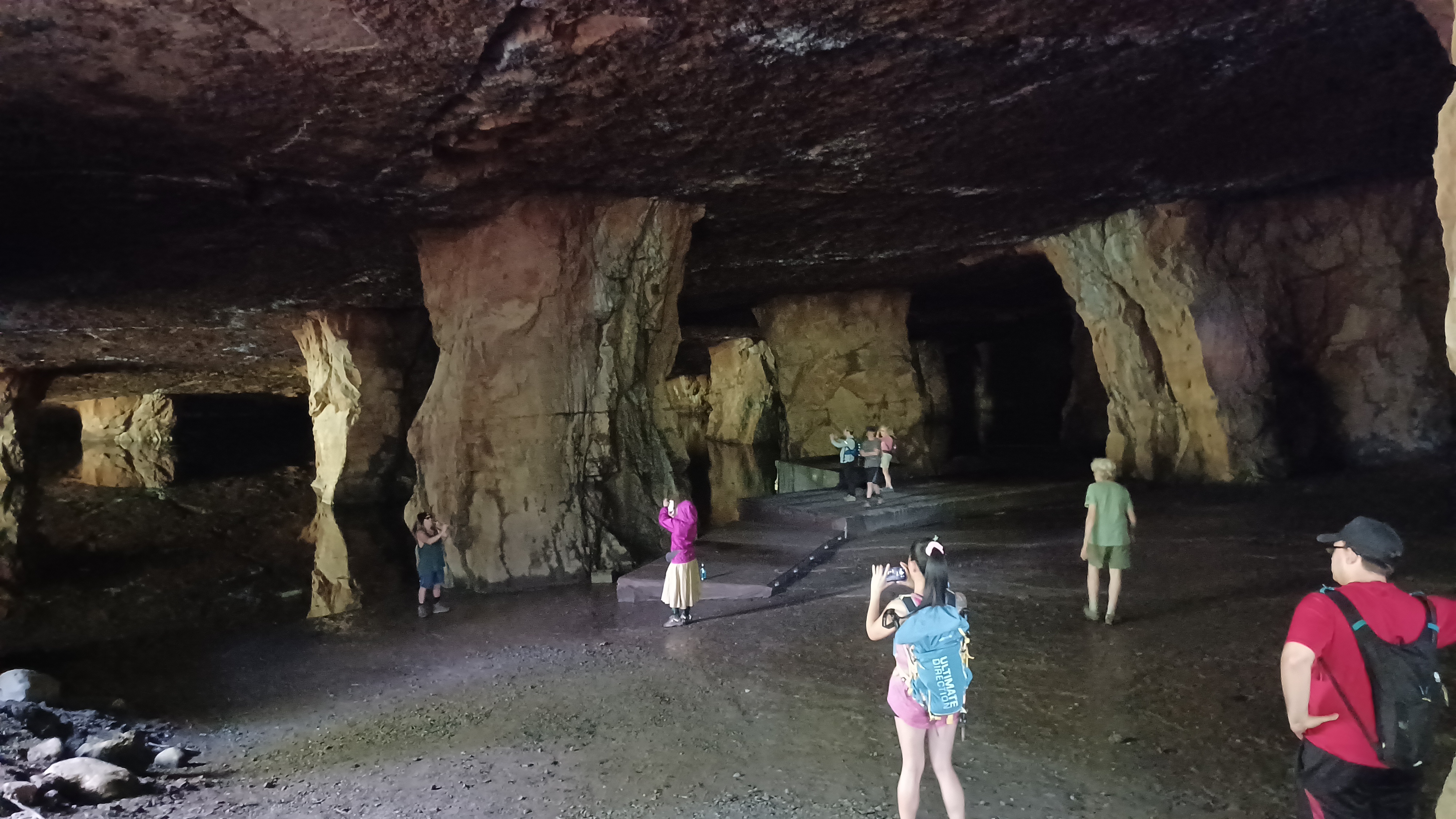
We didn't go for the museum tour this time, and instead just headed uphill to the Widow Jane Mine to have a look around.

Bill Merchant is absolutely outstanding, because he's not only involved in Rosendale, he is now a trustee at the Century House, and deeply involved in everything. He knows details in great minutia, and with normal patrons, he has to reiterate the basics to everyone all the time, but never tires of it. It must be nice for him to have groups of people like us, who already have a frame of reference for everything he's invloved in, and who appreciate the details he has to offer us.
We went into the mine, and heard lots of the history of the area. When we arrived there, there was a guy in there playing a flute, so we tried to be quiet as they tried to get a recording. Ev was surprisingly quiet for the time we went in while he was playing. The acoustics in there are amazing.

There was also someone there that was arranging a mine yoga thing. A lot of different community groups have been using the space, which is cool.

So much of the mine is now under water level. The nearby Lawrence Mine, which we couldn't go in, has much more accessible. We could walk a mile out through that and not cover the same thing (the first time I went through, we had to crack glow sticks to find our way back out).
Widow Jane Mine is apparently named for Snyder family widow, as the 1870s atlas maps on the property to the west name the owner as a Mrs. Snyder, where usually it is the man's name on those old maps if he is in fact alive.

We headed back down from the mine, and the one old abandoned building was standing uphill to the left. Mr Merchant says it is pretty much too far gone, which is a shame because it would have been good for a live in caretaker on site. I remember going into it back in 2010.

As we headed down the road from the Snyder Estate, Mr. Merchant showed us a long slip where canal boats could come in from the main canal, just across Rt 213, and sort of back up into this masonry laid thing that was almost like a lock, so material could be loaded onto the canal boats. Barber's book refers to this as a basin, and at first one might think it was that, but there was definitely stone work down below, which Mr. Merchant says they recently had cleared.
We said goodbye and continued on our way along Rt 213. In this stretch, Lock #9, one of the Lawrencville Locks, was obscure to us up on the road. Lock 9 had a lift of 10 feet.

We continued along the road, which was still narrow, with some reprieve when we reached a cement mine on the left, which has some sort of industry operating out of it. Cement piers to some sort of elevated rail or tram or something broke away, and continued along the south side of Rt 213.

Where these piers parallel the road and canal, there was a six arch cement kiln area along the canal below, but we didn't get to see it. here.

Lock 8, which also had a lift of ten feet, was below us to the right on private land near to homes and such. We were probably too high on the road to see it at this point unfortunately.
Lock 7 was 10 feet also, but that was just ahead and we didn't get right to it.
The road was pretty bad a couple of spots. We were able to meander along the edge of some old cement industry, through Lawrenceville section, and we had one spot where there was no shouldere on 213 at all. It was a long straightaway for a bit, so I waited until there were no cars in view ahead, and ran with Ev and the stroller where I had just enough time to get by. People would have gone around us anyway, but I still wanted to get out of there as quickly as we could.

We turned to the left on Binnewater Road. That's an old Dutch word for "side", and many narrow flows around side streams are known as Binnekills. The road goes uphill parallel with this Binnewater stream, and after a bit reaches the dam to Snyder's Pond.

I had hiked through here maybe in 2013 when there was still water flowing over the top of the masonry dam from Snyder's Pond. Now, no water flows over the top and is piped to the side instead, which maintains a lower level in the pond.
Also, there is now a trail that goes all the way around the Snyder Pond, so we crossed the top of the dam and followed the nicely mowed trail around the east side, and below Binnewater Road.
Pretty soon, we came to the Wallkill Valley Rail Trail parking lot, which has giant cement kilns lining the end of it. We crossed Binnewater Road and ascended a bit to reach the railroad bed.

The Wallkill Valley Railroad began in 1866, stretching from the south at Montgomery where it connected with the Erie Railroad main line. It was originally built in the six foot Erie gauge.

The line extended north through Walden, then Wallkill, Gardiner, and was extended to New Paltz in 1870. By 1872, it bridged the Rondout to Rosendale.
Steamboat magnate Thomas Cornell purchased the line and extended it further north to Kingston. It was operated by the Erie for ten or so years, but then after that eventually became part of the West Shore Railroad as a branch line.
Conrail took over the line, and it was reported that the piers of the Rosendale trestle had shifted, and it was not worth the expense to fix them.

The line was abandoned, and most of it was removed in 1983-84. A section of team track remains in Kingston, and the southern stub from Walden to Montgomery, and an extension south to Campbell Hall is all the remains.


I've talked quite a lot about this like with John Rahl, who owned the trestle the first time I went across.

He purchased the Railroad Franchise, which as per these old laws should give him rights to the entire line, but no one in modern day even understands railroad laws now. One story I've been told is that Rahl owned taxes on it, and the other one, which seems most accurate, is that Ulster County siezed the line because they claimed to need it for buried utilities associated with a prison on the south side of the county. They took it, and never put in the utility. They also put a trail in, but not near the prison, so it is not a through route.


Rahl told me he had his guy look at the trestle and deemed it safe, and that his guy does inspections on other major bridges including those in New York City. He doesn't give up on it, but it seems like Ulster County won't listen no matter what.

While we were heading to the south, there was a wonderful cold air coming out of one of the Joppenberg Mines, at the edge of Joppenberg Mountain along the railroad bed. The opening looked pretty good, so I had the group stand with Ev while I went over to have a closer look.
Karen, Mike, and Heshi all went in behind me. Karen went ahead and down into the mine further. It required a turn in, then a short climb up, then a bit of a shelf, then a drop down to continue in. These mines were probably far larger back in the day, but I have been told they all badly collapsed.


Steve and Heshi went further, but I opted to stay close to the entrance in case Ev hollered.

We headed out from there, and then continued to the south, to the trestle.
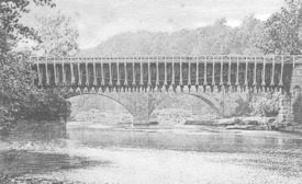
We soon reached the Rosendale Trestle, which was built in 1905 by the King Bridge Company to replace the original 1872 structure due to instability issues.
The views from the bridge are absolutely amazing. The Delaware and Hudson Canal is directly under Rt 213 from the base of Lock 7 and under the bridge. It was hidden from view in the trees and has a carport put on top of it.


I was able to emulate a couple of historic postcard views from the bridge as we went across.

We headed into the trees on the other side, and the old Rosendale Station used to stand on the left side of the bridge, along Mountain Road. The site is now rather grown over. I tried to do another then and now showing where the station used to stand.
We headed into the shade from here, and the route would be much more pleasant for the rest of the day. The smooth ground put Ev right to sleep for a while.
I celebrated with a Founders brew called Curmudgion's Better Half, which was absolutely excellent. We passed the Giant's Ledge Trail to the right, which we made our way through on a hike last year, and then continued on the rail trail ahead.

As we walked, a continuous thumping sound got louder and louder. We soon arrived at a small trail side concession stand, pavilion, and a group doing a drum circle and chanting.

This was the Two Row Wampum 10th Anniversary Concert, "Honoring the River of Life (Guswenta)", and the concession is called the Rail Trail Cafe.
2013 was the 400th anniversary of the Treaty of Tawaganshi Hill (now Albany), where colonists and Native Americans decided they would live in peace and not interfere with each others lifestyles and beliefs. On that anniversary, it was decided that hydraulic fracturing, or "fracking" was in violation of that treaty, and a flotilla of canoes was sent down from Onondaga to the UN to renew the treaty. Fracking has been banned in New York ever since.


It was a really cool thing to walk up on and hear along the trail. It's good to see a community effort like that happening.

We continued ahead and crossed the farm road where the access to that property was, and continued across another farm access to the south.
The pleasant route was surrounded by farms, and we crossed many lanes along the way including Old Canaan Road, Cereus Way, Portuese Lane, Cragswood Road, and Coffey Road.
In the middle of a field section, there was a side trail on one of the farm lanes that went to Coppersea Distilling, so we took the side trip to that.


We went inside, in a sort of barn open air type of place, and I had a shot of one of their things, which was nice and smooth. Karen got a frosty thing, and amazingly we could just take the stuff right back to the trail.

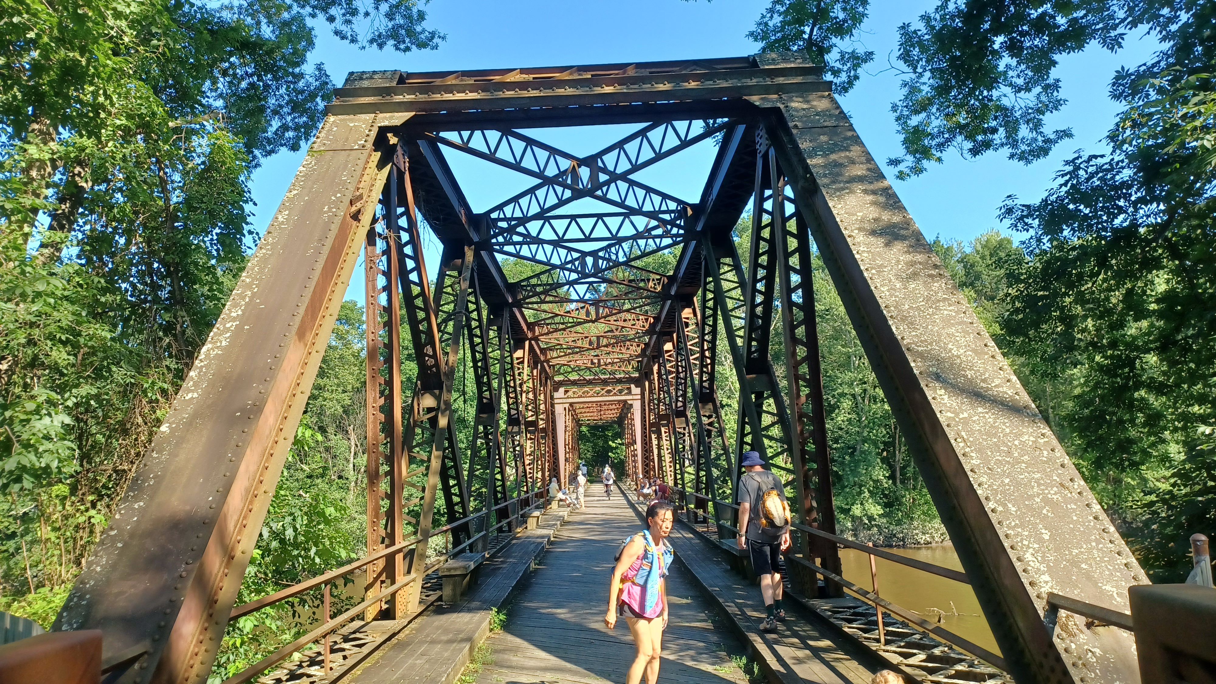
We walked back to the rail bed, and headed south to cross Springtown Road, and then the Springtown Bridge, a through truss bridge over the Wallkill.
I had swam under this bridge before, so I knew I had to stop to do it again. We headed down to the edge and had a really nice break under the bridge, but I was the only one to go in. It seems to be that way quite a lot this Summer.
Ev had a nice time throwing stones and such again while I took a dip.
Soon, we were back on the railroad bed heading toward New Paltz. Some of the group went ahead, and they would miss the side stuff I had planned because they'd go directly back the rail bed.
I actually amended the route a bit to excluse a bit down further in New Paltz, and added a bit in another preserve.
After a long, nice section of woods heading south, we reached Huguenot Street at the north side of New Paltz. Here, we turned left and then immediately right into the lawn of the Jane Bullowa Conference Center. We continued to the right along the tree line, past the Mid Hudson Regional Information Center, then turned left across Old Kingston Road former route, across Chestnut Street, and then into the parking lot for the Church of the Nazarene.
I don't know what the deal was with the church. It looked like an abandoned lot with someone working on a car in it.


We continued from this lot out to Sunset Ridge Road, and began walking that to the east. Matt helped by carrying Ev on his shoulders at this point. He used to hate riding that way, but all of a sudden now he likes it.

We passed an abandoned house on the right of the road on the way out before the cul de sac, and at the end, to the right of Duzine Elementary School, we got on a trail heading into the woods of Mill Brook Preserve.
We went up slope a bit, and the trail evened out. This was not a very hard one to push the stroller through, thankfully, so when we got to the first trail intersection, rather than take the most direct route, we went to the left around the north side of the preserve.
It was the green trail we took in, but then went left on the blue trail to the north. We soon passed by the Julie Seifert Learning Circle, which was a nice cleared area with logs for sitting. This preserve seems very geared into outdoor education.
When we reached the intersection with the pink trail, we turned left and continued along the north side of the preserve. A side trail to the left from this leads out to Hummel Road, which was a route I'd considered coming in on when I was planning the hike, but it looked like I could have less paved surface moving by going in where we did.


We went over a very long section of puncheons on the pink trail, which were very nicely done.

We then came to the yellow trail. Pretty much every time there was a wet area, there were more puncheons or bog bridges. This could be a little rough pushing the stroller through, so Matt helped to carry Ev through these parts while I pushed the stroller.
We turned left on the green trail, and then left on the orange trail through young successional forests of eastern red cedar, and then came out on George Danskin Way.
This road had a very wide shoulder, so it was a pleasant walk. It changed names to Lent Drive, and then we turned left on Waring Lane to the south, another pleasant development road.

This took us out to Henry Dubois Drive, which is the route of the Empire State Trail. It follows streets through the north side of town, but kind of sucks compared to the downtown, so I didn't bother walking that bit.

We didn't bother walking it this time either. We went right across the street and into the Meadowbrook Farm development. There are pedestrian walkways through this area, which we used past the apartment buildings, and then came out to the main road, Meadowbrook Circle on the south side.
At the end of the development, there is a set of steep steps that lead up to behind the New Paltz Plaza where we were parked.


A lot of us were pretty hungry, so while most of the group left, some of us went looking for food.

Matt went back with some of the others to get my car for me so we didn't have to drive Ev back in another one. Ev and I went to the west of the plaza a little bit, because there was a place that sold burritos called the "Smash Shack".
We went in and had a burrito, and this giant thing was delicious. I was terribly stuffed after that. I had all of this extra time to make sure I hadn't been drinking anything bad before driving home, but sometimes eating too much food can be worse. I was ready to go into a food coma from this thing.

Typically, when I put myself in a situation like that, I end up having to pull over and take a power nap on the way home, but thankfully Matt came to my rescue again and drove much of the way home when I was getting too tired.
Before we finished this hike, we hammered down the date of the final Delaware and Hudson series hike to take place in one month.
It seemed almost unbelievable that this could be coming to an end after so much time, and how badly it was stalled.
I'm already planning, that when it ends, it's just another beginning. I'll continue with the Empire State Trail. I'll continue hiking along the Hudson, both north and southbound, because those were part of the navigable waters. Maybe I'll push more heavily to a Champlain to Chesapeake series.
Whatever it is, it'll continue.
No comments:
Post a Comment