

Hike #1564; 8/6/23 Marlin Hills to Bethlehem with Justin Gurbisz, David Adams, Brittany Weider, Evan "Joe Millionaire" Van Rossum, Diane Reider, Violet Chen, Stephen Argentina, Jesse ?, Carolyn Gockel Gordon, Anne M, Professor John DiFiore, Karen Lee, Robin Deitz, Chris "Cupcake" Kroschinski, Darlene Perez, Serious Sean Dougherty, and Mike Piersa

It was time once again for my annual March on Musikfest hike, which is one of the best attended events of the year. I had looked over several different routes, and wanted to be sure that I had something that my son Ev could be in the stroller for. At first, I was going to do the old Bethlehem Branch of the Reading Railroad, which is now mostly Saucon Rail Trail, with some other stuff, but I would also be doing that again as part of the PA Highlands series, so I really didn't want to do it just yet.
The music arts festival has taken place annually since 1984, with German themed stage names "platz" meaning place.

Free music stages are found throughout the festival, with a few fee events for nationally known artists.

Metrotrails has had an annual March on Musikfest Hike every year since 2005, and is one of our best attended events every year.
I decided what I could do this year would be to come up with something a bit more odd, and much more new.
I came up with something that really interested me from the southeast, which was something I'd never done into Bethlehem before.


My dad lives on Morgan Hill out of Easton (and so does my brother now), and I'd spent some time over there driving around backroads and checking things out. That was when I found the old school house at Kingston Park we had recently visited, and other stuff.

I'd recently done the hike from that area, known as the Marlin Hills, back to New Jersey, but I found a route that looked good heading west from there. Old Redington Road along the Lehigh is a narrow, one lane route that seemed like it'd be cool to hike. I had been wanting to do it for a while, and this was a good opportunity.
The route I planned would involve the Woodland Hills Preserve at the old golf course, then the old area of Redington, and then through Steel City, across the Lehigh, through Freemansburg, and then a bunch of oddball trails, fields, and development paths as well as a cemetery back into Bethlehem. I figured the route would be very interesting.


The day before the hike was to happen, Cupcake posted on Facebook that we'd be doing the Musikfest hike the next day, and Ev's mom saw it so she made plans to take him herself so I couldn't.

I always get upset about this initially, and the best I can do is to try to plan something around it that I wouldn't have done if Ev were with me. That turned this hike into a bit more of an adventure than previously planned.
We met at Iqor in South Bethlehem, as we'd been doing the past few years. When I started doing these hikes, we had different parking areas. Back in 2005, the parking was the Brodhead lot in South Bethlehem near Lehigh University. That lot was later closed to all but school use, and we started parking at Martin Tower on the north side. The tower was closed, and so we switched to either the Home Depot on the north side, or Iqor on the south.

From here, we shuttled with as few vehicles as we could to the start point at the Woodland Hills Preserve.

This is an interesting preserve that was formerly a golf course. It was preserved by the township in 2014 and turned into a nature preserve. It seems to be a trend with golf courses where many of them in different areas are turning over to parks as interest in golf is waning. We've seen it at Forever Green above Stroudsburg, Cherry Valley National Wildife Refuge near Delaware Water Gap, the Union County NJ park where their music fest events are held, and others I can't even think of right now.
We headed into the preserve straight, and then made the first right turn. On my previous trip, we weaved around through the middle before following some of the perimeter, so this time I decided we would follow the extreme perimeter around the entire property.

The route shifted between improved surface paved path and just mowed path. Not all of the trail system follows exactly where the golf cart paths used to be. It comes and goes from them, and passes by a couple of pavilions along the way.
It was pretty bright, but not quite as hot in this preserve as the previous time we were there.
We got a little reprieve under some evergreens along the edge when we got to where we had been on the previous hike, at a set of overgrown steps the present day trail bypasses.

We continued to the east side of the preserve, through a pretty area of meadow. I find it kind of odd that they call it Woodland Hills when really it's not very wooded at all on the former course. It is a good succession study with the transitions between meadows and young forest.
We continued north when we reached the east side, dowhill and then up once again to probably the highest point in the course. We all paused there because this was where we left the property on the last hike, near the religious place that apparently took over some of the buildings from the course.

We turned left, and the trail around the perimeter gave us a lot of extra distance. It didn't just follow the perimeter; it weaved around through the lands and was really quite pretty.

I was ahead of the group most of the time, who otherwise congregated closely together. Stephen was running behind, and so he ran sort of clockwise around the outside of the preserve while we were going counterclockwise, and met up with us in this area.
We headed along the northern perimeter to the western perimeter, which had mowed access to a private house. We accidentally took this from a path, but found that one of the former golf cart paved paths was right along the edge of the yard.

Of course, I figured this was part of the trail system, and we followed it along their yard. No one said anything to us, and I get the feeling we're not the first people who have made this mistake.

The paved path went into a tree cover, and then swerved into the woods to the left, away from the private land. It got to be pretty overgrown, and so we had to bushwhack a bit to get back out to the main trail again. It was a bit frustrating, but we were okay.
We got back to our cars and the parking lot again, which I wasn't sure would happen. I figured there might have been a chance of leaving the preserve a different way than we went in on the west side, but there wasn't.

We headed out to the parking area and then to Countryside Lane, where we turned to the right. We headed slightly downhill here, and then reached the historic Lutz Franklin School house.

Built in 1880 in Late Victorian Style, the one room school house was used for education until 1958.
The building was restored 2004-2006, connected to Kingston Park. It is now home to Lower Saucon Township Historical Society Museum. Historic Beers Atlas maps from the 1870s show that there was a school on this site prior to the stone one there today as well.
We headed in past the school and into Kingston Park where we used the restrooms and took a little break under a pavilion. There, I told the group of my plans ahead.

When I found out that Ev wouldn't be with me, I looked over the maps and figured on some things that we might do as an alternative.

One of these was a stream culvert beneath Rt 78 that I felt surely must exist, but we didn't know what it would look like.
This wasn't something that everyone had signed up for, so I didn't want to force it upon the entire group. I offered the rest of the group the original planned route, and we would meet up with them again at Redington Road.
We headed past the school and turned left on Countryside Lane again.

After passing by a dead end road to the right, I went up into the woods, off to the right, because it looked like there was a bit of a grade and maybe a slight path there.

It was definitely something at one time, and I figured maybe it was part of an earlier road alignment from before Rt 78 nearby was built. Off to the right, there was a big pit, which I thought might have been an iron mine since we were in the South Mountain formation, and there were mines up there.
It was likely, I found later, that this was just a minor stone quarry just off of Applebutter Road, just ahead. A couple of people in the group followed me through this, and we cut down to Applebutter Road from there and turned right, a little east of where it goes over Rt 78.

Some of the group went ahead here and turned left on Lower Saucon Road.

We made the left turn onto Helms Road, which is now a dead end, but used to go on through before Interstate 78 was completed. We continued past all of the homes on the road, and then reached the dead end where there were barricades over the remainder of the paved road, to the Rt 78 fill.
There was a bridge just beyond the blockage, where the road crosses a small tributary known as Bull Run. That is the one that goes beneath 78. We continued on the road ahead of there, and Joe Millionaire ended up spotting an impressive stone ruin near the highway fill. I suspect this was the ruins of a grist mill that stood on the stream long before 78 was built. It was just the stone shell of the building remaining.
Also, just after the abandoned bridge, there was once another road that went to the left, back toward Kingston Park. This road too was abandoned, possibly even earlier than when 78 changed the road alingments in the area.
When we reached the 78 fill, we turned left and climbed down to the stream.
There was what appeared to be a box culvert going under the highway, which I thought might be fine. I stepped inside of it, and there was an immediate slide down to a round pipe. It reminded me of the pipe underpass I use near JT Baker Chemical in Phillipsburg to get out to the Delaware River.
It was a steep grade, and much longer than the one I'd done in the past, and it had a good amount of water going down it. I decided I would check it out first.

I was able to step onto the slide without a big problem, and had enough grip with my shoes, but part of my problem was that I wore my beat up thrift store bowling shoes down this.

As I was making my way down along the wall, I lost my footing and began sliding at a fast rate down to the pipe.
This was incredibly frightening. If the pipe had been a big drop, I could have been dead. I didn't know what awaited me at the bottom of this drop.
I skinned my elbow going down, but other than that I was fine. I looked ahead and could see the light at the end of the pipe on the other side. I couldn't be sure if it wasn't a vertical drop from there, but at least I knew I could walk through it.

I got up and let the others know I was alright, soon others followed me. I think Stephen climbed down the same way as me and did the same slide.

Jesse and Brittany both came down the slide after that, but they went in the middle and had much more grip than I'd had, so they did it without falling.
I started walking through the pipe ahead, which seemed fine. As I approached the other side, the water continued to get deeper. Before I was through, the water was up to my knees.
I stepped out the other side into a shallow pool, beyond which was another slanted drop with large blocks in it.

This is a device used to take pressure away from the flow of water below. By slowing down the water with this device, it keeps it from causing major erosion issues downstream. Quite an interesting thing.

I figured we'd be able to climb down this without too much a problem, as long as it wasn't too deep at the very bottom. A bit of this was a gamble, but we pulled it off.
Several members of the group went back and walked the roads around to Redington Road, and used the underpass on it beneath Rt 78.
I was quite surprised that the majority of the group decided to push on through.

As I stood at the edge of the erosion deterrent blocks, which reminded me of a sort of 3D Pac Man (others have told me Q-Bert, but I have no idea what they are referencing except that it's another game), I listened back for the group behind us. I heard a whoosh sound, and a scream, and it turns out that was Joe Millionaire making a similar slip down the drain. He also got away with only a scraped elbow.

Stephen made his way down the crazy slope of concrete first, followed by Jesse. I followed both of them, passed Jesse, and then followed Stephen's recommendation to go to the right rather than the left at the bottom because there was shallower water and better footing.

This slope was such that they were easy to stand behind, but we had to step with a foot down to the next one, then let gravity bring our bodies forward to grab the next slab of concrete. It was actually pretty fun.
It took us quite a while to climb down this thing, but it was definitely the kind of adventure the hikes had been needing for a while!
When everyone was down, we made our way downstream a bit over slippery rocks, and then turned to the right up a slight slope. We could see a woods road fording the stream below in this area.

As we headed up, we came to the pavement of the other end of the road. We re-grouped again, and began following the old road sort of west.

At a bend, we could see another road grade continuing downhill parallel with the stream. Old maps show that this road was once a through route, but has been also abandoned for a long time, probably longer than the rest of Helms Road.
After a corner, we came upon an impressive abandoned farmstead. The farmhouse on the right was in rough shape except for an upper level addition that had been worked on not so long ago. Old collapsed barns structures with good stone walls on the north and south side were in place on the other side of the road.
This was such an interesting spot, but we opted not to bother with it. I was glad we did, because just a bit ahead we came out behind no trespassing signs, when there were none from where we had walked in (not surprising I guess).
I'm not sure if the road right of way is still municipal or not, but we got out of there before we upset anyone.
We turned left onto Redington Road, and headed northwest a bit. This lightly traveled road is quite nice. Just below it is one lane only along the Lehigh River in a narrow section sandwiched between cliffs, the former Lehigh Valley Railroad, and the Lehigh River.
This area was the community of Redington, a company town of the Coleraine Iron Company, which operated until World War I when it was taken over by Bethlehem Steel.

Before we started to descend into the Lehigh River basin, we passed a private residence that used to be church for the little town, built in the 1800s.

At the bottom of the hill, the others were waiting for us at the entrance to a fish and game club. That road going to that used to go through as well, but has been closed off for a very long time.
We waited for a while, and a guy who lived in the last house before the top of the hill drove down to make sure we were alright and see what was going on. Of course, it is not often that one sees a big group of people congregating along this little used road.
We had everyone together except for Cupcake and Darlene, and I finally called them to see what was going on.

They were somehow in possession of a lost dog that had come out from the woods while we were walking the road, and they were trying to figure out who it belonged to.

They weren't finding anything, and it was taking them forever to catch us, so we had to continue walking down the road to the west.
There was a really nice slope and cliffs in this section, and occasionally a good view of the railroad tracks.
The Lehigh Valley Railroad was one of the original Anthracite Railroads, and the the first competitor to the Lehigh Coal and Navigation Company, including it's subsidiary, the Lehigh and Susquehanna Railroad, which was leased to the Central Railroad of New Jersey in the 1870s.

The first section was completed between Easton and Allentown in 1855, and of those two lines that usually operated on opposite sides of the Lehigh, this is the only one that is still in service today, though only for freight sadly.

A train came by as we were just above heading eastbound, which was pretty cool to see from above.
Barely any cars came by the entire time we were walking this road, and it was pretty well shaded until we got closer to Steel City. As we approached that area, the road became two lanes again, and we went by where there is a famous hill climb for ATV enthusiasts. We saw one guy riding around, but didn't witness anyone take on the famous hill. Also in this area, another train went by on the tracks, this time a longer one with double stacked containers heading westbound.

As we walked, on the right side of the road was the historic Richard Freeman homestead, close to what is today Steel City, built as early as the 1760s with one substantial addition.

Freeman came from England and first lived in Allentown before building this beautiful home on Redington Road.
Richard Freeman's ancestors would become namesake of the town of Freemansburg, across the Lehigh River and just west of here.
Ahead, in the hedge row to a house on the right side of the road, there were large blackberry bushes. Usually, blackberries are the least favorite of the local species of raspberries we find growing.

Black Raspberry is different, sweeter, and Japanese Wineberry is great but a little more caustic. The blackberries are more tart and have a larger pit center than the others.

These ones, however, were absolutely delicious. The best blackberries I'd ever had, and they were huge! We stopped and ate a whole lot of them.
We walked up to the left into Steel City Park, into a ball field for a little break from the road, but then there was an annoying chain link fence I had to go around to get out of it. Some of the group had more sense than me and went around it on the road.
On the right side of the highway, off into a yard, there was also a beautiful reproduction of a Lehigh Valley Railroad station.

The sign on the edge of it read West Portal, which was a stop in New Jersey, so named because it was that portal of the Musconetcong Tunnel, one of the longest railroad tunnels in New Jersey.

I'm not sure if any of the station building is actually historic of if it is just a replica, but it is cool to see.
When I hiked the Lehigh Valley Railroad through this area in 2003, I remember coming up on a property that had an outdoor train layout in it, and I suspect it was probably this property closer to the tracks.
I was in regular phone contact with Cupcake and Darlene, who were on their way, but way behind us. Darlene did a good amount of mileage, but hadn't done this in a while, so they opted to Uber out and maybe try to meet at the fest later.

They passed us in their Uber as we were walking down the road to the west.

As we continued through Steel City, there was another surprise fruit, a pear tree on the right side. We picked a few of those and ate some more.
Pretty soon, we arrived at the Freemansburg Bridge over the Lehigh. The original bridge at this site was a covered bridge, then an iron truss bridge, before the current one was built. There used to be steps down on the west side that led to the passenger station on the Lehigh Valley Railroad, all gone today.
At the north side of the bridge, I changed the trajectory of the hike again.


I had planned to go right here, along the Lehigh Canal a bit, and then climb up to other parks and such, but that was the stroller plan, and at this point, we had taken so long with everything we'd already done, it was better to go more direct.

We went down steps in Freemansburg to the Lehigh Canal towpath and regrouped under the bridge, with plans of going more directly west to Musikfest.

There was a Henry Fonda film, I think from 1934, called The Farmer Takes a Wife, which was set on the old Erie Canal, but they used footage on the Lehigh Canal in Freemansburg for those scenes, because it looked so authentically like the Erie would have in its heyday, and the Lehigh Canal had just closed here in 1932.
As we headed west, we had a look at a spot where we could see some of the remnants of a Bear Trap Lock dam, which was basically a dam and lock in the river that allowed boats to simply ride a deluge of water below, but there was downstream only traffic.

This started in the Lehigh I believe around 1819. A formal towpath canal was warranted with the amount of traffic, which started service in the late 1820s.

Serious Sean joined in with us on his bike in this area. He had been working on his new house and missing a lot of hikes, and had by himself carried a piano into his house earlier in the day.

He'd rented a box truck to get it, and he had to return it to I think somewhere around Hellertown, and put his bike in it to ride and catch up with us.

We continued along the towpath until we got to the Minsi Trail Bridge, where we stopped for a break and took a much needed dip in the Lehigh. It was quite refreshing, and from there we were able to shift around a bit and do some more exploring.
It was suggested that the group, during a night hike, had traced some of the old Central Railroad of New Jersey right of way on the berm side of the canal. I had bushwhacked this route myself years ago, and it was absolutely awful to do as I recall. With this assertion that it was now passable, I definitely wanted to do it again.

We continued across the Lehigh Canal, which had some small amount of water flowing in it, but it was rather easy to cross. Some of the group went up and over the Minsi Trail bridge to try to find another way over and down to us.

We walked to the slope on the other side, and found ourselves in an insane thick mess of grape vine, which had inundated everything all around us probably the worst I had ever seen.

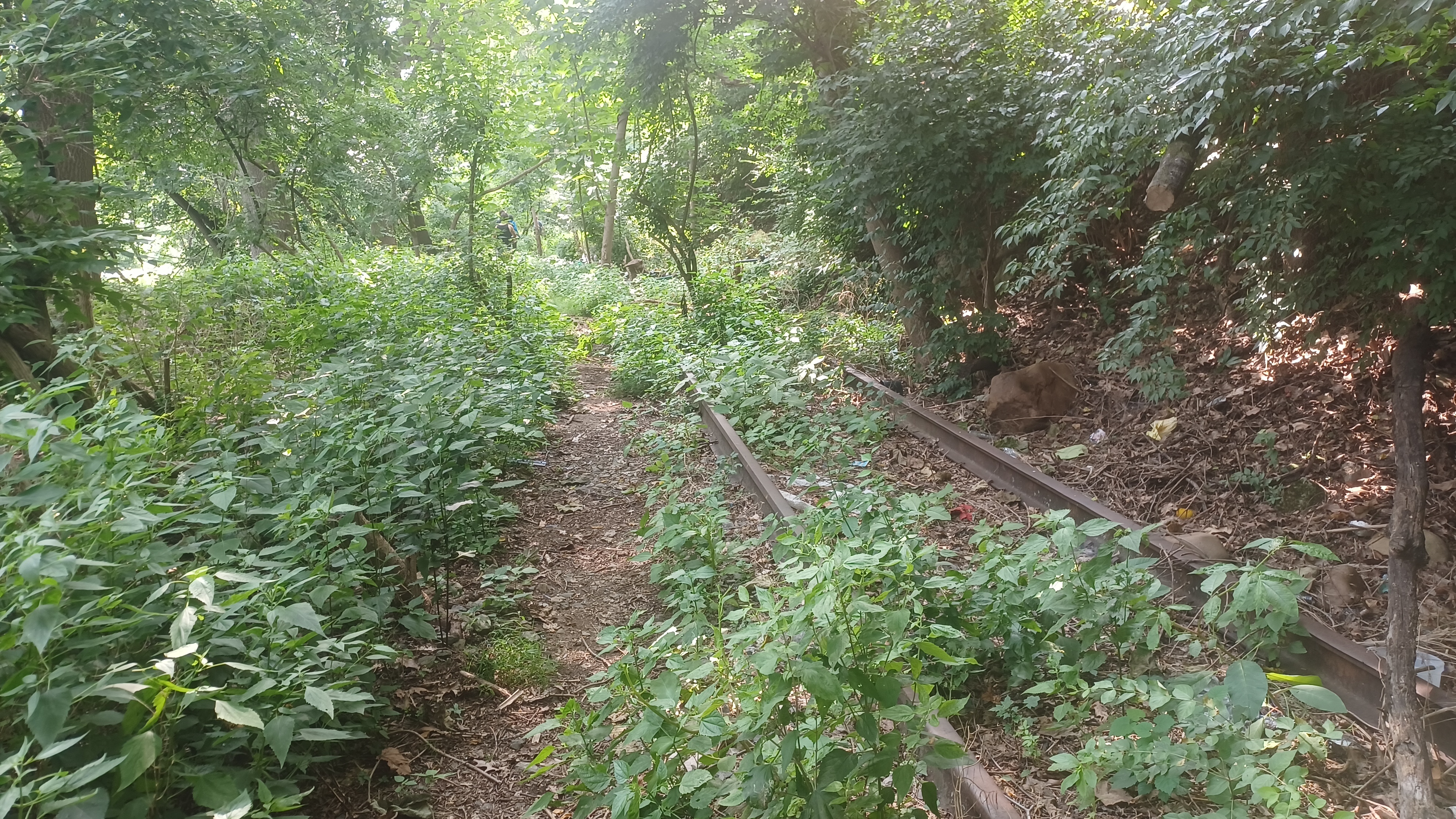
We turned left on what I think was part of the railroad right of way. It was a path, but there was no way of telling it was there. There are still tracks in place through this section, but it was so thick we would never have been able to see them.
Soon, we made our way into woods with enough of a canopy that we could see around.
The tracks came into view just to our right, and the clear path went across and then parallel with them for a good while. I thought this section was abandoned in 1986, but they were definitely in a big woods.


Someone else told me it was 1983. The largest trees there were Ailanthus, the invasive Tree of Heaven, which grow super fast, so they could easily have gotten that big in thirty some years.

I've gotten quite a lot of jokes already about this being the "trunk line" because of the trees growing through.
There were quite a few tents of homeless people out in this section. Some of them may be occupied, but we didn't see anyone back there while we were there. I figure it was because they might have jobs they were going to during the day.
The first shanty we'd reached was inundated with grape vine and certainly not occupied, but the rest were in reasonable shape.


We continued along until the right of way started getting pretty badly overgrown. It was getting to be a chore to get through it, but we were directly below the cemetery I'd been wanting to walk through as part of my original plan, so I decided we would try to climb up a dry wash to the right from the railroad bed, and end up in the cemetery.

Nisky Hill Cemetery was established in 1864 as a Moravian burial ground. It seems to have annexed the earlier Union Cemetery, which has much earlier burials than that in one section of it.
We followed the south edge of the cemetery, past the veterans area, and then out toward the north side of the Fahy Bridge. We shifted inland a bit, and walked through some of the Moravian College campus to the west.
Eventually, we reached the Main Street, and continued to the north into Musikfest.


This is where it becomes very easy to lose people. We tried stopping at a place that sold wine or something, but I decided against getting some expensive stuff there, and we all continued north on the main drag through the fest. It was nice going this way, because we could just see what was going on.

When I reached the end of Main Street, we turned around and I had no one else with me. I found some of the group congregated in the middle of the road.

I'm sure we lost some of them somewhere there. Jack and Sarah were not on the hike, but they were hanging around Musikfest trying to catch up with us, but we never did end up seeing them.
I picked up a four pack of Fegley's Hop'Solutely IPA, which was quite good, and just over 11% abv, so it was my style. I cracked one open and enjoyed walking more through the fest with the others, who I joined up with again just ahead.
We continued on down the main drag again, and then took a set of steps down below toward the old Waterworks and Monocacy Creek.

Somewhere in this area, some of the group got on line for some kind of food, and I saw cheeseburgers available just across from them with no tickets needed, and no line. I grabbed up one of those really quickly and scarfed it down.

From here, we headed south a bit more and made our way to the Wooden Match, the former Central Railroad of New Jersey station. The line we were following in the woods is overgrown to the station, and then is rather clear just ahead. Some of it ahead of there is still used, but some of the tracks were only removed from that area within the past year.
We went around the station to the left, and then out to the Lehigh Canal. The railroad and the canal crossed the Monocacy Creek right next to each other here. The canal crossed on an aqueduct, and a narrow one replaces the original one that would have carried boat width.

This small one just keeps the canal watered in the area. Immediately adjacent to the aqueduct was Lock 42, which raised or lowered boats 8.2 feet.

I've been taking a dip in the aqueduct back there for I guess 17 years. They've fenced off some of it to keep people from going in, but I never have any trouble with it.
Some more of the group left us around this area I recall, but Mike Piersa, from the Museum of Industrial History, showed up there to greet us and go over some historic stuff for the remainder of our trip!
From here, we headed onward following Mike on the towpath below the lock, then turned right on the historic truss bridge over Monocacy Creek. This is known as the Sand Island Bridge these days.

The rare pony truss bridge was built in 1867, and originally carried Township Line Road over the Monocacy Creek. It was built by the Beckel Iron Foundry and Machine Shop of Bethlehem.

It is a rare example of a cast iron truss bridge.
The style is the rarest type of historic bridge in America, and the mid Atlantic has more examples than any other region.
The bridge was rehabilitated and relocated to cross the same Creek at Sand Island Park in 1991.
From there, we were on Sand Island, and we continued to the steps up to the Fahy Bridge. We crossed over the bridge, and then down into South Bethlehem. I wanted to make my annual stop at Lehigh Pizza, because they're pretty great, and have some specialty slices.

They also sell cans of Four Loco, and it used to be that you weren't allowed to drink them inside, but now you're allowed to drink them if there is more than one person sharing it. I pretended like someone was, and had a new one flavor I'd not had before.

From there, I left it up to Mike where we'd walk heading on toward Iqor. He took us through the downtown, and pointed out new construction going on, and talked about the future.
We headed to the east on 3rd Street for a bit, and there were buildings under construction. One of them looked to be an older facade but may have been new, and one of them was definitely new. Mike explained that this is a new south side revitalization. I must say it does seem more appropriate that the existing centers be multiple story buildings in proximity.

There is a Rite Aid across the street from the new buildings, and Mike was saying that this was supposed to go in a couple of years as well, in favor of some new similar development more appropriate for the downtown.

I'm still not happy that the historic Banana Factory is to be torn down and replaced with a new building, but ArtsQuest can do what they want I guess.
We headed to the south slightly, and went over to the Museum of Industrial History where we got more dissertation, and Mike showed us "Tug".
"Tug" once operated inside of the sprawling buildings at the steel complex, moving heavy items around. A railroad coupler is a fixed to the front end in the nose position. The vehicle is still operable! Mike offered to start it up for us, but we declined this time because we had a good amount more to walk.
The machine is not a rail one, but rather a rubber tire vehicle with extreme strength. It had a smile face and eyes affixed to it. Quite an interesting piece of equipment.
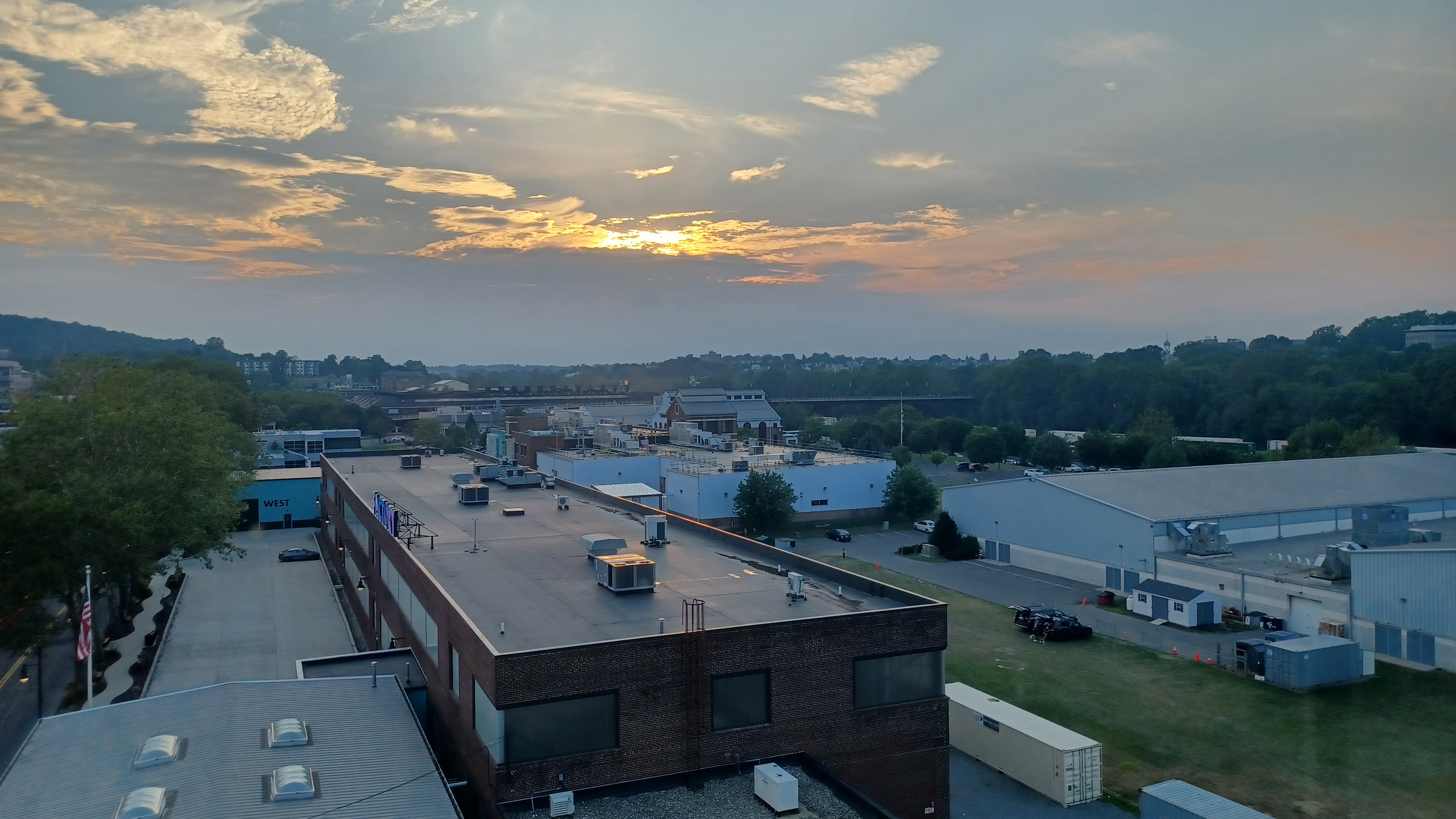
We made our way to the east a bit more, and Mike brought us to the top of the new parking garage in the area, which affords an amazing 360 degree view of the Bethlehem area, which he was able to give an excellent dissertation on.
Some of the vacant buildings in immediate proximity were perfectly viewed from this spot. These were the Iron Foundry site in South Bethlehem, Bethlehem Steel. Previously, it was the Bessemer Steel Mill. It contained the Bessemer Converters that converted iron to steel. Built 1868-1873. First steel made in 1873.
John Fritz was in charge of construction, which took a long time because he wanted it to be an industrial cathedral.

The building originally extended 931 feet long.

Beyond, the "steel stacks" and Hoover Mason trestles and such were all in view, at the Bethlehem steep proper site. Mike described that one of the furnaces was built in the same foot print of a much earlier one.
Bethlehem has roots in the iron industry dating back to the first industrialization of the site in 1857 as the Saucona Iron Company. The name changed in 1861 and Bethlehem Iron Company operated on the site until 1899, when the owners of the company founded the Bethlehem Steel Company. Five years later, the Bethlehem Steel Corporation was founded to be the steel company's corporate parent.

The American Steel Industry faltered in the 1970s, and Bethlehem Steel ceased all metal production on this site in 1995. Bankruptcy was filed in 2001, and dissolution of the corporation took place in 2003.
There has been major redevelopment of Bethlehem Steel as the Sands Casino, now Wind Creek Bethlehem.

We headed down from the garage building, and then through the area around the Steel Stacks area of old Bethlehem Steel. Mike headed out in this area as we continued on our way back to the cars.


We went beneath the Hoover Mason Trestle, and then past the casino buildings. We went under the Minsi Trail Bridge, and then beneath the giant crane with the Wind Creek sign on it.

We passed the old High House, where treatment of forged material was performed, and it wasn't very long after that we got back to Iqor and the end of our trip.
I drove John and I forget who else back to their cars at Woodland Hills Preserve.
As I was backing out, my car just died. Right in the middle of the parking lot. I called John up because he'd only recently left, but didn't realize that his car is not able to jump start, because it's a Tesla.

I was stuck. I didn't know who else to call, although I should have called my brother or my dad because they're not so far away, but I didn't want to bother them.

I ended up calling AAA, and they told me my battery was shot and I needed a new one. They were going to charge me a couple hundred dollars to install it right there, but I told them let's hold off.

I was able to get it jumped, and I was on my way back home.
The exhaust had recently fallen apart, and so it was not working very well. The idle would cause it to stall.
I was so stressed out about what I was going to do about all of this stuff going wrong, but fortunately it somewhat worked out.
In the end, it was a good thing I didn't have little Ev with me, scared in a parking lot at night in a car that wouldn't move.


Serious Sean ended up riding his bike all the way home! At least I didn't have to do that!
No comments:
Post a Comment