

Hike #1515; 11/13/22 Dobb's Ferry to Northvale with Jennifer Tull, Brittany Weider, Justin Gurbisz, Carol (CJ), Professor John DiFiore, Robin Deitz, Serious Sean Dougherty, Rob Farrell, Diane Reider, Violet Chen, and Everen
This next hike would bring us to something we'd been intending to do for some time now: the Tappan Zee Bridge.

The new bridge had had a walkway added to it that was not available on the old one, and the three-mile section of the Hudson River would make this probably the longest bridge I have ever walked across.
I wanted to come up with a really good hike that we could include this on, and the timing was perfect since it would be stroller friendly, and I was trying to switch up all of my hikes so that I could bring my son with me.
I came up with a route that would put us near Rockleigh on the NY/NJ state line, and hike to that spot from Dobbs Ferry in Westchester County. There seemed to be some trail along the Hudson that could all be tied together on the east side, although I didn't realize just how extensive it was yet. 

I figured we would do this, hike to the bridge, cross, and then follow the old Erie Railroad right of way to the south, which I had hiked already almost ten years prior, but would be worth doing again.

I spent some time going over what I thought the route should be, and I figured out what I thought would be a good one ending in Tappan, at the south end of the Joseph B. Clarke Rail Trail, which follows the old Erie Railroad bed. Mr. Clarke was my good friend Shane Blische's uncle.
We had a problem when we arrived at this trailhead, in that there was not enough parking for everyone. The paved trail was already being used by dog walkers and joggers in the area. We had to take up basically all of the room there, and some of the group was forced to go across the street and park their cars there while we waited. I figured we might have to move the cars to a point to the south since there was no room, but it ended up working out because we had just enough spaces considering those who shuttled to the start.

I of course headed to the starting point because I had to have the car seat for Ev. Justin also headed out that way, and he had pulled off on a side street.

It was a pretty easy but sort of long commute north and across the new Tappan Zee Bridge.
Our starting point in Dobbs Ferry would be the old Dobbs Ferry railroad station along the Hudson. There are twenty five non pay parking spots in the lot, and fortunately we were there early enough that we would not have to worry about any permit parking.

The station was first established in 1849 on the Hudson River Railroad. This was one of the main lines to be taken over to become the New York Central. That successor built the current station in 1889. Today it is operated by Metro North through to the city.

The very historic location of Dobbs Ferry was so named for Jeremiah Dobbs, who settled early on at the location on the Hudson. He was a fisherman by trade, but he complimented his income by occasionally ferrying people across the wide Hudson River from this point in his boat called a "periauger", which was a canoe hollowed out of a solid log.
It was really windy when we arrived, and it took me a little while to get everything for Ev all together. I made sure to have my Ninja Turtle blanket to put over him for most of the day to keep him warmer.
Once we were all together, we headed out to the edge of Waterfront Park with all of the views of the Hudson River and the Palisades formation beyond. 

Tallman Mountain was almost directly across from us, and the New Jersey Palisades were just a little more to the south. We could see the New York City skyline down the Hudson to the left pretty clearly.

We began walking to the left along the waterfront, and we could see the new Tappan Zee Bridge there as well.
The site is originally named for the Tappan sub-tribe of the Lenape Nation who lived here, and "zee", for the Dutch word for a sea. The three mile wide area is one of the widest spots on the entire Hudson River.
The original Tappan Zee Bridge was a cantilever structure completed in 1955. It was expected to last only 50 years, and the location over the brackish todal section of the river left it open to salt water corrosion. It was overburdened and structurally inefficient.
As the story goes, the location was steeped in politics right from the spot. 

It seems that it is the most foolish spot they could possibly consider for a bridge, being the widest spot.

However, the spot was chosen because it is at the exact location it needed to be in order to be out of the jurisdiction of the Port Authority. This is apparently why the tolls aren't so high as they are on the other Port Authority controlled bridges.
Work began on replacements, twin cable-stayed bridges, in 2013. The northbound span was completed in 2017 and the south in 2018. The north span now has the pedestrian route 3.6 miles long.
The old bridge was officially called the Governor Malcolm Wilson Tappan Zee Bridge, but the new one was named the Governor Mario M Cuomo Bridge and dropped the heritage name altogether. Most still refer to it simply as the Tappan Zee, as I will continue to do in this write up.

I haven't read into much on Mario Cuomo, but I do have big issues with his son, Andrew Cuomo, who resigned as Governor of New York State after accusations of sexual misconduct. 

My big problem with Cuomo was his push of false information I witnessed personally with regard to the pandemic, but I won't get into that here again at the risk of having yet another of my journal entries deleted.
Plenty of things out there are named for politicians, and most people agree that naming for living politicians is usually a bad idea. In this case, direct family of the politician making that call also does not sit well with me.
I think the thing that bothers me the most is that the heritage name was stripped from it completely. In this day in age, especially among Democrats like Cuomo, we see a very strong politically correct, sometimes even as far as pandering support for people of limited demographics, but when it came to the Native America name here, it was overlooked and let go. 

We continued on along the waterfront on the paved trail to the north side of the Waterfront Park, and I saw fences and assumed we couldn't get through any further. Of course I was wrong, and I'll have to go back and do it again.

There was a path behind a fence we would have just had to go around, and then another bridge over the railroad tracks that would have saved us a little bit of time, and potentially added some other cool little spots.
Instead, we turned back through the lot and passed our cars, and then reached the pedestrian bridge over the former New York Central tracks. There was an elevator that I could bring Ev up to the top in rather than use all of those steps, which was fine. Brittany rode the elevator with me while the others took the steps.
We crossed over the tracks, and then jumped in the elevator to the other side, but accidentally took it all the way to the bottom. We only needed to go down one sort flight of steps that we didn't need the elevator for.

We came back up and exited the elevator, then turned left on Palisade Street adjacent to Dobbs Ferry Memorial Park.

There was a path through the edge of this park that continued to ascend off road, but because it was stairs, I figured it would be tougher, so we just kept on ahead along the road.
Near the top, behind some homes, there appeared to be a way to get back on this route. We went over to it behind a building, and the route down on the stairs was so overloaded with fake cobwebs. Clearly, the locals that use this (or don't) don't want anyone going through there.
We walked to the right and I had to turn Ev around backwards to pull him up more steps behind the playground, and we eventually came up at a road known as Ogden Park. We turned right there, and headed into downtown Dobbs Ferry, which was quaint. It was just a two block walk further uphill from here to reach the Old Croton Aqueduct.

I had led an entire series of hikes on this historic route and trail in the past, and revisited like we did this time to tie together other bits of greenways we wanted to do.

The Old Croton Aqueduct was developed in 1842 as a clean drinking water source for New York City, the first significant "piped" water from upstate. One of the designers was Jonathan Jervis, who was also much responsible for the early Delaware and Hudson Canal we'd also been hiking.
Manhattan was fast growing in the 1800s, but the local businessmen made a grave error when they built a tannery along the shore of the Collect Pond on the south side, the main drinking water source for lower Manhattan. Without it, water borne pathogens became very serious. Something had to be done.
The Croton Aqueduct was a stone lined waterway that was built to drop one foot per mile from the Croton River in Westchester County all the way to Manhattan. 

The original Croton Reservoir was a square structure that is now known as The Great Lawn in Central Park. It was further piped down to an Egyptian style above ground reservoir on the present site of the New York Public Library. That building is actually built on the reservoir footings.

By the late 1800s, the old aqueduct was already replaced by the "New Croton Aqueduct", but in many ways the new one, which employed more inverted siphons and was far less noticeable, lacked what the old one had. The old one basically had a promenade walkway on top of it for its entire distance. While most of it in Manhattan was destroyed, the majority of it in Westchester County was preserved and is now a State Historic Park.
I became enamored by the historic route about 2010 and decided to hike the entire thing, which I finished. We even walked the entire historic route of it down through Manhattan even when there was very little to see. The only part I couldn't get directly on was the part now under the water of the New Croton Reservoir. 

Just before the end of the developed area, I think it was Diane noticed a case of beer sitting next to the trail. It was almost an entire case of Bud Light! I thought maybe it was some Hashers or something that had placed it but I kind of doubt it because it was in such an obvious spot.
I don't drink Bud Light, but it does happen that we get these mooches that want my good expensive beers from time to time, and it would probably be a good thing to have some crap beer to hand off in such a situation! I took all of the beers out of the box and loaded them into the undercarriage of Ev's jogger stroller just in case!

I don't drink Bud Light, but it does happen that we get these mooches that want my good expensive beers from time to time, and it would probably be a good thing to have some crap beer to hand off in such a situation! I took all of the beers out of the box and loaded them into the undercarriage of Ev's jogger stroller just in case!
I only planned on being on the old aqueduct route for a bit. We went a few blocks through the town and entered the woods to the north, which is a really nice section.
There was a bit of some steps to get down to the lower level on the aqueduct, and everyone helped me get the stroller down, although I ended up dropping a bunch of those beers along the way. 

I probably would have looked like some crazy lush with all of this cheap beer strewn about if anyone had seen. We only realized there was a ramp after we got mostly to the bottom.

We crossed the road entrances to the Mercy College, and it had been my intention to walk through the campus closer to the Hudson River, but unfortunately this wouldn't be possible because it was loaded with no trespassing signs and authorized user and the like. We had to continue on the aqueduct until we got to Hudson Road West where we could turn to the left again.
The road was lined with beautiful, giant trees as we headed down toward the Hudson River again. Some sections of the college campus to the left of us still had signs to keep out, but the farther walkways had nothing of the sort. If I'd walked from the north to south, we would have been able to get through without passing such a sign. I wonder if some of it is part of the Westchester RiverWalk, which is a new greenway I'd only found out about this time, but I'm not sure.

The official website for the Westchester Riverwalk doesn't show anything "Under development" in this area, but it does have dotted lines for areas that area complete but with "restricted access" so this was probably one of those.

There was a good walkway along the road for the last descent down to the former New York Central/MTA line along the river and then the Ardsley-On-Hudson station.
The handsome station building we came upon was built in the mid 1890s as part of the Ardsley Casino country club through the support of notables such as Cornelius vanderbilt, J Gould, and JP Morgan.
The casino and Club closed in 1936, and the depot associated with it is the only surviving structure. The area of the country club is casino is now the site of Hudson House Apartments.
We meandered past this site along the road, which then weaved back to the right and gradually started climbing again. I had studied the aerial images of this prior to find that there was a good path into the woods to the left, that led directly into the next developments. I really enjoyed laying out the start of this hike, because it was like what I was doing more regularly when I was planning my night hikes, and I haven't been doing anything so much like that lately. This was a more creative route than some of the things I'd been planning with the stroller.
The path weaved through the woods a little bit, and then came out at the dead end in the end of Half Moon Lane, named for the ship Henry Hudson sailed up this portion of the Hudson on in 1609.

We continued north on this road, with its big houses, and then reached a four way intersection. Straight ahead along Buckhout Street, the Half Moon Apartments were on the left. 

A sidewalk leaves the corner and moves closer to the apartments, making it a perfect walking route, a bit away from the roads. It felt almost like doing another greenway trail.
We continued on these pathways to the end of the apartments, and we had to head back out to Buckhout Street.
We followed this road ahead to the intersection with Astor Street on the left, where we'd turn to go down closer to the Hudson again.
We were now in the river town of Irvington. On the left and on this corner was the sprawling Cosmopolitan Building. The three-story structure was built in 1895 as the headquarters of Cosmopolitan Magazine, and designed by Stanford White in classical Revival style, modeled after the Vanderbilt Museum of Hyde Park.

The site, along the Hudson River, was chosen by magazine owner John Brisbane Walker because he wanted an office close to his Irvington home.

The magazine left Irvington in 1905 when it was purchased by William Randolph Hearst.
Today, various offices occupy the building, but it is still quite a lovely piece of architecture. It was kind of disappointing that there was not a single historic marker about any of this stuff. I had to look up so much stuff myself on this, which can kind of be fun, but its sad that those less curious don't have access to the information.
On the next corner where we'd turn to the right, once again parallel with the old New York Central along the river, the Red Barn Bakery, featured on Martha Stewart's show, occupies an old automotive garage. Most of the group seemed to be getting kind of hungry, and this was a vegan bakery. Having two friends in the group who were pretty much vegan made this a must stop.
I didn't bother going in because of some virtue signaling vibes I got from some signs, and instead ate a tastykake apple pie I'd brought with me to share with Ev outside.

Sean came out with this big plate of pumpkin pie stuff that was vegan. It had no cholesterol in it, just sugar, and he gave me a piece to try. 

It was actually quite impressively delicious, so I second guessed my initial reaction to the place. I gave Ev a piece of that as well, and he seemed to really like it.
This place was pretty upscale because it was garnished with all sorts of stuff. Sean kept handing me stuff from it to try; the main part of it was definitely a soft pumpkin pie, but there was some other almost nutty flavored edges to it, and then fruit things. He handed me a weird fruit thing with sort of the shape of a starfruit, but it had something inside it that looked like a little grape tomato from the small bit of it I could see. Whatever it was, it was delicious also, but probably a good slice of the cost of the pie too. Sean also gave me this enormous wad of super sweet frosting that was several inches thick. 

It was like a butter cream but only better, sweet but not Duncan Hines sweet. That wad of frosting surely canceled out any healthy amount of exercise I would be getting this entire day.

Brittany also got some key lime pie and I'm not sure who got what else.
The Scenic Hudson Park is on the other side of the railroad tracks from where we were, and while I wanted to see that section, I decided against going on through to that because it would take so much time to go out and around, and we had a long way to go still. I would have to come back to do a more detailed covering of everything we'd see on this hike, so it was just one more thing to add to the list.
We walked along parallel with the tracks, and to the right was the handsome Lord & Burnham Building, which almost looked like an armory or stronghold of sorts. 

Built in 1881 to replace its burned predecessor, it was a factory that manufactured greenhouses and boilers. Today, it has been converted to upscale residences and is home to the Irvington Public Library.

Just ahead from here, we re-joined some of our group members who had hurried ahead to find a restroom. They were waiting for us at the Irvington Station on the former New York Central Railroad, built in 1889, designed by the Shepley, Rutan, & Coolidge architectural firm.
The original station at the site opened in 1849 under the Hudson River Railroad.
The town was originally called Dearman, but efforts to change it in honor of author Washington Irving, who lived just to the north of this site at his modest home estate called Sunnyside, were already underway despite the fact that he was still alive the time.
This station continued to serve as a ticket office until 1957, after which it was utilized by various other businesses. Today it is a quaint Cafe and part of the Irvington historic district.


There was a tunnel beneath the tracks at the station, and then a bridge over them to the park a little bit beyond. There was the perfect picture opportunity at the top with a gas pump sign reading "EV" with an arrow. I parked Ev in his stroller to the left of the sign by the arrow to get a great shot. It could mean "Ev has gas" or whatever funny thing.

Matthiessen Park stretches further up along the Hudson from this point, but we didn't take time to go into this either. There's just so much stuff to see, and so far to go, it just got more and more apparent that I needed to come back for a repeat visit.

I had done some of the side parks on a hike previously on the section between Dobbs Ferry and Ardsley-On-Hudson, but there's still so much more.
We continued to the east at the bridge on North Buckhout Street to look and see if there was any way of continuing through without going on streets, but it didn't look like there was any way. At the next ninety degree bend in the road, there were more steps but only into private land. We continued south once again to Main Street, and then turned left to go east.
Up ahead was the beautiful old Town Hall building, constructed in 1902. Outside the southwest corner of the building was a giant stone Bowl trough with a somewhat legible epitaph or something on it
The history of it located on the small marker reads:
"This stone bowl was originally part of a horse and dog trough at the intersection of Broadway and Harriman Road in Irvington. It was dedicated to Dr Isaiah Ashton, a family doctor who came here shortly after the civil war and traveled by horse and buggy to tend the sick and deliver babies. In early 1889, he suffered a fatal skull fracture in a carriage accident. As a tribute to him the double trough, with elaborate metal ornamentation, was commissioned. It was designed and built by A.J. Sackett of Tarrytown.
Because “Horseless Carriages” kept hitting the monument, It was moved to Main Street and North Ferris in 1954."
Just past the big bowl was the entrance to the town hall, and I was rather surprised to find the front door wide open. I asked the others to stand with Ev for a few moments while I checked it out.

Justin, Brittany, and I went in to the front hall, which was beautiful with wooden paneling everywhere.

There was a set of stairs and wing hallways going left and right from there, and a main room ahead that was closed. Just inside the door, there was a public restroom on the left as well as a public reading room with tables. It was apparently a stipulation that a reading room be kept available when the public library, which was originally housed in this building, was moved the previously described location.
Just outside of the building just to the east was a nice statue of the character Rip Van Winkle, the man from Washington Irving's story who fell asleep for one hundred years beneath a tree. I got a funny photo of Brittany lying next to him, and then we found it quite humorous when we left a full can of Bud Light in his left arm.

The old Main Street School was just behind the town hall on the slope to the left, and in the parking lot a farmer's market was going on. Of course, we had to check this out as well.

Just as we walked into the place, there was a food truck to the left selling empanadas. I'm always a succar for those, so I got one chicken and one beef. I figured it would be something good I could share with Ev as well, but on these hikes he gets fed pretty well as it is. CJ had been feeding him apples pretty much all day, and he loved those.
They were too hot to eat at first, but Ev ended up eating some of each of them.
We walked all through the farmers market, and I was disappointed they didn't have any local wineries present, but oh well.
Rob waited online for something, I'm not sure what, but it took them like a thousand years to get it, but everyone else was meandering around so he wasn't holding us up either. 

I used the opportunity to give Ev a diaper change in the grass along the Old Croton Aqueduct, which borders the school parking lot just to the right.

A deer was scared of all of the commotion but fences on the uphill side kept it from running away, so it kept trying to ram into them. Eventually it moved off ahead down the trail and was okay.
When everyone was good to go, we started moving along the Old Croton Aqueduct again to the north.
We crossed Matthiessen Road, another driveway, Fargo Lane, Meadowbrook Road, and then turned left on Sunnyside Lane. It was my hope that we might find a way to walk through Washington Irving's old estate to get to the Lyndhurst Estate to the north.
As we approached the property, the entire area was chain link fenced so we couldn't get through except the main entrance and would probably have to get the tour. 


I really do want to do the tour there, but this would probably take quite a while and I couldn't really spare any of the time yet. So, instead we continued walking back to the north the way we had come to go back to the Old Croton Aqueduct.

This ended up being a nice walk because it forced me to notice the crumbling old landscaping from the Sunnyside Estate that is no longer in use.
There was a set of lovely stone stairs and a mostly missing bridge over the little brook that flows through. Just upstream from that, there were two more pretty stone arch bridges that at least partially crossed the same brook, both of them out of use and crumbling. Without walking the road, one would likely not have seen any of this.
We could also see some of the stone work that carried the Old Croton Aqueduct over the brook as we came back to it.
We turned and followed the route to the north for a bit, which wet through a very nice wooded section. We watched to the left for any trails that might come through, and there was another area with a chain link fence that probably would have blocked us if we'd tried to go through anyway.

Ahead, the Belvedere Estate was above us on the right. The manor house was not in view, built probably in the 1910s and then extended upon and upgraded in 1928 when it was purchased by Dr. Philip Gillette Cole.

He named the property Zeeview for the Tappan Zee and around this time greenhouses and out buildings were added. We could see the greenhouses, which looked to now be abandoned, to the right of the aqueduct trail. The property was later purchased after Cole's death by Samuel Bronfman of the Seagrams Whiskey family, and he renamed it Belvedere after his main residence in Toronto. In 1972, the estate became the center of operations for Family Federation for World Peace and Unification. Today it is an event and meeting venue rental property.
The first part of the trail that is named the Westchester RiverWalk we came to crossed the aqueduct trail here. It emerged from the right on what must have once been one of the Belvedere Estate roads. It then descended a bit from and paralleled the Old Croton Aqueduct before turning away from it. I studied a trailside sign that told of where the trail was or was at least proposed. It made the prospect of doing more of these Hudson hikes that much more interesting.

While I was looking at the sign, two women were walking by. I did my usual greeting "beautiful day for a walk" or something.

I think one of them asked where we were headed, and either myself or someone else said we were heading for the Tappan Zee Bridge. The one woman said "Well you're going the wrong way! The bridge is back that way!" and she pointed to the direction we were coming from. I felt that this was a mistake someone from around there wouldn't make, and that she was just trying to keep us off of the section of trail to the north, which was where they were headed.
I smiled at the women with a knowing look and said "No it's not...". The same woman replied "Oh. Yeah. You're right" and the two of them moved on. If they indeed were lying to us just to keep us off of their favorite section of trail, it just goes to show the kinds of snobbery we have out there. I hope it was just a silly mistake.

We continued along the trail below the aqueduct and old greenhouses, and then started to turn away to the west.

We passed between some lovely trees, and then came to a fee parking area at the Lyndhurst Estate. The trail went down the access road to the left, but since we got in this way, we took the opportunity to explore some of Lyndhurst. There was a trail that went right across and beneath some sort of dry stick or vegetation arch. The famous mansion was just above us to the right.
The building was originally the home of William S Paulding Jr and his son Philip R Paulding, and designed with architect Andrew Jackson Davis in 1838.
Paulding was a military officer, politician, and mayor of New York City in the 1820s.

The country villas was named simply "Knoll" for its promontory location above the Hudson River at the wide Tappan Zee.

The younger Paulding resided at the home until the 1850s, and the property was purchased by NY merchant George Merritt in 1864. Architect Davis was brought back to design the expansion to the house making it one of the most impressive Gothic Revival style homes in America.
Merritt retained a Master Gardener, Ferdinand Mangold, who transformed the rolling farmland of the Knoll into a landscaped country estate with ornamental plantings, specimen trees, and walkways. "Knoll" was renamed "Lyndenhurst" for the large Linden trees planted around the house.
Merritt died in 1873, and his widow Julia chose to sell the property.
Railroad Tycoon Jay Gould purchased the property in 1880. Gould retained Ferdinand Mangold as gardener, and beautiful landscapes were further developed.

Jay Gould died in 1892, leaving his eldest daughter Helen as Steward to the property. She opened the property to free trade classes for disadvantaged children and supported women's programs.

After Helen's death in 1938, the youngest Gould daughter, Anna, took ownership and continued charitable efforts and the home remained a country estate.
When Anna passed away in 1961, she left the entire estate of the National Trust for Historic Preservation. The museum and historic site opened to public in 1965.
Once again, we had a very long way to go, and so we didn't bother wandering through the house this time. We just enjoyed the look of it from afar. We did walk up to these weird skeleton horse statues they had on display while going through though.
There was a good path going through the upper end of the property, and some impressive historic photos printed large on display signs on the property.

I used one of these to take a photo of Serious Sean sitting at just about the same site as another guy in the historic photo on the same spot over a hundred years prior. 

It is amazing that so much of the property remains as it was.
The property is also full of all sorts of beautiful giant trees.
The pathway we followed went somewhat steeply down from the knoll and to another lower building, which I could not positively identify yet. It had a restroom inside, but it was clearly an older building that served some purpose. Justin went around and looked through the windows to discover that it was a very old bowling alley.
It turns out this was the 1894 Helen Gould Bowling Pavilion, and it was much more significant than any of us would have realized at the time.
The two-lane bowling alley is the oldest regulation bowling alley in America, built just before the codification of modern bowling regulations.


An avid sportswoman, Helen Gould insisted that bowling could be enjoyed by both men and women.
Gould also opened this building for sewing classes, for underprivileged children. 

We could see into one of the windows that had photos on display, I assume of the two Gould sisters who each oversaw management of the site.
There was an excellent view of the new Tappan Zee Bridge in front of the bowling alley building. The road in front of it is also now the route of the Westchester RiverWalk, so we were back on course.
I had seen the trail route north from this point on the google maps, but didn't expect such an extensive plan that would effect our future hikes.
We continued ahead and through a gate onto the paved trail through very nice woods along the river.

The railroad tracks were always below us to the left, not always visible. The Montefiore Health System property was above us to the right, and had gates with locks and codes to access, and the NY DMV was on the hill above that a little further on.

The entire section was just lovely and secluded.
The two women that maybe tried to direct us the wrong way passed me in the front in this section, and I just commented "this sure is a beautiful section". The woman I'd talked to before agreed in a tone that almost sounded disappointed.
I paused when we got to the trail bridge over the Sheldon Brook, which flows from along the Montefiore place, because there was a lovely cascade just upstream as well as a second foot bridge on that property, but it was closed off. There was also a nice waterfall just below the trail, but there was no good spot to view it from and Ev had fallen asleep, so I didn't want to leave him with someone else in case he woke up and saw someone other than me. 

So I went without seeing that waterfall closer.
The trail weaved around on the slopes and came to a viewing spot with an historic marker telling the story of the area, from Henry Hudson to the bridge.

The river had widened to the three miles by this point, and it is no wonder Henry Hudson thought he might have found a passageway to the west when he reached the Tappan Zee.
Just ahead of this point, we were closer to the railroad tracks, and there were outstanding views of the Hudson, the new bridge, and of Blauvelt Mountain section of the Palisades formation, which doesn't have the dramatic cliffs like the other sections do, but are still pretty mountains.
The trail didn't stay in the open very long. It soon came to its end at the dead end on Van Wart Avenue.

I waited for the rest of the group to catch up to us there, and we all walked the road out to Paulding Ave, and then out to Broadway.

We turned left on the highway there to cross over Interstates 87 and 287.
I let everyone know that this area just to the north of the iterstates would be the last stop where food would be available for a good while, perhaps until Sparkill, but no one jumped on it. We crossed over some jughandles, and then on the left was the entrance to the new bridge walkway.
We stopped at the new restrooms they'd put in, which were standard government crap with the automatic stuff, which will break of course. Government always does things the most expensive way that is not sustainable. 

I've learned a lot from parks and the foolish developments they put in restrooms. Aesthetically, they did a great job. Everything from path surface to the approach to the bridge walkway looked quite nice.

In this area, there were also some really great history panels that went over the history of the Tappan Zee.
It didn't go as far back as the Native Americans and Henry Hudson on this one. They started with the early 1900s here, and discussed the ferry crossings between Nyack and Tarrytown. This followed with bridge discussions and oppositions.

It was understandable because some two hundred homes had to be removed in order to build the highway and bridge. 
They weren't going to build it further north because that would encroach on the Rockefeller land holdings. They weren't going to go farther south because that would be within Port Authority jurisdiction.

They weren't going to build it further north because that would encroach on the Rockefeller land holdings. They weren't going to go farther south because that would be within Port Authority jurisdiction.
I would suspect so many used the bridge at the start just to shun the Port Authority tolls.
The originally planned bridge was going to be a sort of bowstring arch suspension, but there was a lack of bidders, so the cantilever design was used.

The bridge carried 29,000 vehicles per day in the 1960s, 66,000 per day in the 1970s, 74,000 a day in the 1980s, 112,000 per day in the 1990s, 134,000 per day in the early 2000s, and 140,000 in the 2010s.

When the shared bicycle and pedestrian path opened to public in 2019, it was the longest example of such a thing in America.
As we headed out, we could see the former New York Central line below us, and there was even an abandoned control tower of sorts within view to the right.
After a bit of walking, and with lined glass along the edges switching to chain link and then to clear glass, we came to the first rest area.

The walkway with approaches comes to about 3.6 miles total, and so they have these seating and viewing areas at intervals across the bridge. The first one was levels of seats and steps.

Serious Sean brought some of the best coffee stout by one of his favorite breweries, Three Floyds, and it was the best coffee imperial stout I've ever had. It was called Crushing Mass.
The reflective thick glass was often good for photos, but sometimes too annoying with reflection.
I fell a bit behind taking photos and such at the little outlet area. I moved on ahead from there out to the next one, which was set up with more normal chairs, but the near ones were upright with a back rest, and the back rest tilted on down to the far side where it was intended for laying down.

The group was lined up on it with the farthest ones laying down and the near ones sitting upright. Sean with a beer in his lap.

The sky was looking more blue, and the bright sun was periodically shaded by the somewhat sparse cloud cover at the time making for perfect photos as we got to the main towers of the bridge.
The viewing areas were great because they not only provided a view out, but we could look east and west along the bridge as well, because they jutted out so much. People seemed to think I was using a drone when I published the photos to Metrotrails.
We continued across the bridge from this spot and beneath the giant towers under superb lighting.

It was really something to see, and I tried to take my time to take it all in. I'd already done the rest of the stuff on this hike in the past so it wasn't as big a deal for me, though I wanted to see it again.

The next viewing area had a long bench with no back rest, but a sort of shade cover thing that hung only from one side, and with a sort of checkered floor area.
The lighting was probably best from this one, so I took a few more photos and took Ev to the edge so he could look at the river. One of these things actually had a broken panel with a replacement cover on it. I'd imagine it would take some serious force to break one of these things.
To the north of the bridge, Hook Mountain, the next bit of the Palisades formation, came into view beautifully.

In this area, we soon crossed over the county line between Westchester and Rockland.

The viewing area beyond this one had a sort of ampitheater look about it, but by this time no one in our group was waiting at each one of them. They'd gotten farther ahead of me, and didn't stop at each one.
I continued to push ahead, but always took the time to look off at all of the views.
CJ brought Ev a banana which he was happy to eat.
On the Rockland side, the group did wait for me at one of the next rest areas. These ones actually had some sort of theme to them for interpretation or whatever, and the next one was the Palisades.

One of these things had computer console things or something where if you were looking for more information, you could have it texted to your phone. Justin put it in and had a whole lot of links texted to my phone.

This rest area had long foot rests where one could sit down, but without their feet on the ground, or sit with feet on the ground without a back rest. I think the farther ones were more normal.

We continued from here along another stretch of bridge, which had no towers or anything; it was just spans over wide water. The next rest area had "Fish and Ships" written where it said Palisades on the previous one, and the chairs were individual ones that faced to the east out to the rest of the bridge.
Blauvelt Mountain on the Nyack side was starting to become more prominent in view.
We started reaching the Nyack side of the bridge as it curved to the right a bit. At the end of the bridge, the walkway curved away from the traffic lanes a bit. There was a long sort of pier that went directly parallel with the bridge with boats moored along it.
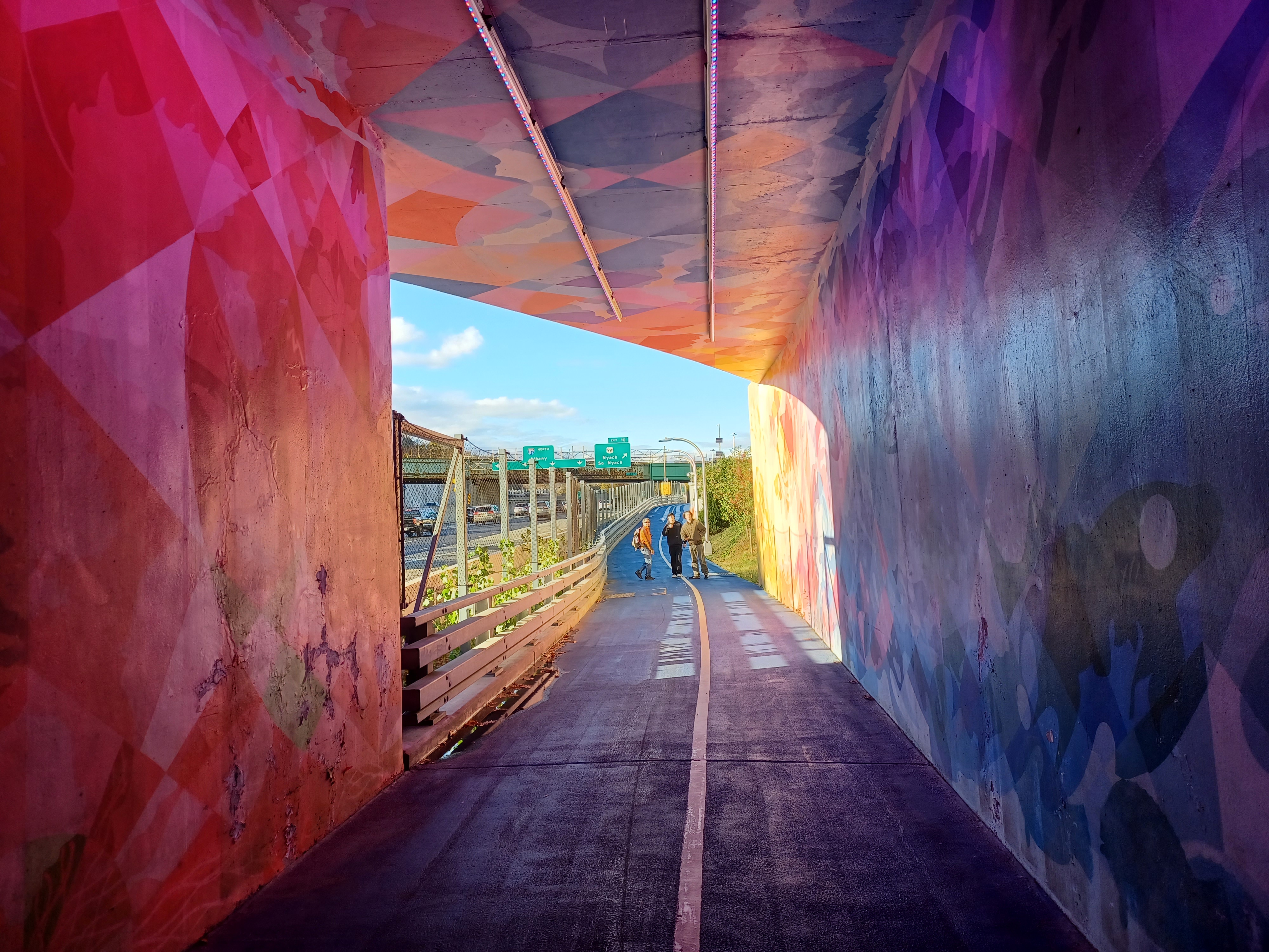
The walkway had to continue on for a while more after the bridge was over. We came back closer to the highway again, and passed beneath the bridge under Broadway in South Nyack.
The underpass was a beautifully painted square culvert with combination abstract and other designs. The title of the full piece on the walls was "The Flux of Being".
A little bit beyond that point, there was a side path that went up to the right. The route leads up to the old Erie Railroad bed, which at this point is the Raymond G. Esposito Trail.
We waited for a bit at this point so that everyone could see that we were turning here, not going ahead to the end of the walkway and visitor center.
.jpg)
While we were there, a guy pulled up on a utility vehicle. He wasn't used to seeing such a large group out there, and asked us if we'd seen the visitor center. 


 |


I told him we were headed for the New Jersey line, so we couldn't really go out that way out of our way.
Once everyone was together, we climbed to the bridge, then turned left across 87 and 287 on the former Erie Railroad to the south.

This branch was completed in 1870 by the Nyack and Northern Railroad as an extension from the Northern Railroad of New Jersey to their line built to connect the old Erie main line at Piermont. As I understand, the South Nyack Station was closed the end of 1965, and the main Nyack Station in 1966. This along with the Northern Railroad of New Jersey were formally leased to the Erie Railroad soon after completion. It was known as the Northern Branch for its later years as it was fully owned by the Erie. Everything north of Sparkill was formally abandoned in 1966.
The rail bed very closely paralleled Route 9W for the first part of it, but it wasn't paved down this far and made for a nice relaxing remainder of the trip.
We headed south and crossed Broadway at grade, and then continued along the edge of a wonderful sloped shelf between 9W and River Road.


Along this stretch, there were a couple of places with some good views of the new Tappan Zee Bridge. I recognized some of theses spots as the same as where I'd gotten photos of the old span back in 2010. I can't believe that was twelve years ago already.

The route went by pretty fast. I got out some of the really great imperial stout I'd picked up previously at the Vault Brewing place, and it was a great stroll. There was one bridge along the way that was kind of neat with old stone abutments that probably date back to when the line was constructed.
The rail bed very closely paralleled Route 9W for the first part of it, but it wasn't paved down this far and made for a nice relaxing remainder of the trip.
We headed south and crossed Broadway at grade, and then continued along the edge of a wonderful sloped shelf between 9W and River Road.
Along this stretch, there were a couple of places with some good views of the new Tappan Zee Bridge. 


I recognized some of theses spots as the same as where I'd gotten photos of the old span back in 2010. I can't believe that was twelve years ago already.

The route went by pretty fast. I got out some of the really great imperial stout I'd picked up previously at the Vault Brewing place, and it was a great stroll. There was one bridge along the way that was kind of neat with old stone abutments that probably date back to when the line was constructed.
More views opened up to the left as we continued, a few of the new bridge, but more came about looking toward the famous Piermont Pier.
The pier was constructed by the Erie Railroad at Tappan Landing in 1838, and was extended a full mile out onto the Hudson. The settlement was renamed Piermont for this most prominent man made feature, as well was "mont" for Tallman Mountain, the most prominent natural feature, part of the Hudson Palisades. No tracks connect to the site today, and lots of upscale apartments and such have been developed out onto it. I hiked out to the end of the pier back in late Summer 2010 when I was recovering from smoke inhalation damage, and it was a really great day.
We continued ahead, and eventually came to the old Piermont Station, a beautiful structure we'd seen before.
 |
| 2010 |

The Victorian stick style structure was built In 1883. The tracks through here were abandoned in the 1970s.
 |
| 2010 |

The stop was a "whistle stop" without a station structure as early as 1873. The stop was originally referred to as "Piermont-On-The-Hill". 

Passengers had to wait in whatever inclement weather came about for the train at this location.
Marion Belle Byram-Kelly was the sort of station master and telegrapher at the site for thirty two years. She married the telegrapher and stationmaster from Nyack, who died six years later and left her a single mother. She continued to live in the station until 1976, and kept it just as it was so that restoration was not so big a chore.
The station was restored beautifully, and with its original color scheme by Piermont Historical Society in 2006.
It is hard to believe that forty trains per day once came through this site.
By the end of service at this site, the line had already earned the moniker "Weary Erie".


The line below this area was completed in May of 1859 as the Northern Railroad of New Jersey.

It was built with the intention to connect the Erie line down near present day Exchange Place and Croxton near Jersey City up to the original Erie main line at Sparkill. This line could then operate on Erie tracks out to the pier at Piermont.
I had saved some photos along the line to my phone to do some then and now compilations. I had already done some of the Piermont Station, but I figured I could do them better, because I wasn't going about it as accurately as I do now when I set those up so many years ago.
When we moved south of the station, I didn't quite notice where the junction was with the branch that went down to the Piermont Pier, but it was getting darker by that time.
 |
| 1960s Piermont Historical Society Archives |

The station is also passed by the Long Path. Serious Sean reminisced that his second major hike with me was in this area, my annual Halloween costume hike in 2013.

It is hard to believe that was nine years prior. On that one, we hiked the Long Path and other trails and then looped back to the west of Blauvelt Mountain.
The Long Path is a major long trail that was intended to connect New York City with the Adirondacks. It was originally not supposed to be blazed at all, but rather an orienteering trail planned by Raymond Torrey in the sixties, but it took on a different identity and had to be changed because too much land went into private ownership and was developed. Now it is all blazed in an aqua color.
I've been working on doing the entire Long Path as a series, and I've pretty much done all of it up through the Catskills.


I'm missing a reroute near my cousin Dorothy's house in Central Valley, and I'm missing a bit west of Middletown, as well as a bit between Port Ben on the Delaware and Hudson Canal and the Catskills.

Aside from that, I've done all of it up to the Devil's Path in the Catskills, and then all from near Featherstonhaugh State Forest to across the Mohawk River. A lot more to do there.
I got three different then and now compilations, and we crossed Hudson Terrace to continue south toward the end.
We shifted direction to the west and the original Erie main line to the pier came in somewhere to our left.
This original route, which later became known as the Piermont Branch, broke away from the later main line in Suffern. Some bits of it are still in use, in Spring Valley and Nanuet, but the rest is abandoned east of Suffern. The station stops were Dater's Crossing, Tallman, Monsey Heights, Monsey, Spring Valley, Nanuet, Blauvelt, Orangeburg, and Sparkill.

We continued ahead beneath Route 9W, and then crossed Piermont Avenue. At this point, the old Erie goes right and is paved, the Joseph B. Clarke Rail Trail (Shane Blische's uncle), and the original Northern New Jersey Railroad went to the left.

It's still unpaved for this bit, but then reaches the southbound junction where it becomes paved as part of the rail trail as well. I think the Sparkill Station used to stand in this area, but I'm not sure the exact spot. It was really getting too dark to try to set up any more compilations at this time, so I got a quick shot and figured we'd have to try to come back.
I think some of the original Erie is under development as a rail trail to the north, so that will be a good reason to come back and try to hike it as well. Little bits of it are also trail out there, so it might soon be something I can get the stroller through.

We continued across Sparkill Ave at grade, then crossed Washington Ste
et and William Street at grade on crosswalks, and continued to the south as it continued to get darker.
Pretty soon, we passed beneath the Palisades Interstate Parkway.
It wasn't much longer and we emerged at Oak Tree Road parallel with Lawrence Street where we had met in the morning. Cars were there, and it was pretty much the end. However, I needed my car and there was no other carseat, so Jenny went back to drive my car back over to the NJ side.

Rather than hang out in the parking lot, Brittany, Ev, and I continued across Oak Tree Road.
The traile ends at this road, but there is still a good path along it from here. I had done it before back in 2010, so I figured we'd be able to muscle on through it, even though it was dark.
It was actually extremely easy to move Ev's stroller along the little path next to the tracks, which started up again just past the trail end. We soon came to the bridge over the Sparkill Creek, and I lifted the stroller over the rails to push it over. Ev apparently threw his bottle at an inopportune moment here, and it was one of the good glass ones. I was not happy about losing that one because I couldn't find another one for him in the car (he was totally peaceful on the ride home anyway so it didn't matter that much there, but it was a good and more expensive bottle).
There was another good path along the left of the tracks just after the bridge again, and we moved on ahead.

In a shot distance, I could see a bit of a small path to the right across the rails and down into a gully below the tracks. This was right on the NY/NJ state line. We crossed and dipped down, then back up to come up in the corner of a parking area.
We were in New Jersey and heading though the parking area to the Shop Rite of Northvale. It felt great to know we made it to a destination where it'd be easy to scoop us up, and we could grab a bit to eat or something.
We headed down to the Shop Rite and meandered through the store for a little bit. I think I got a container of chocolate chip cookies which I shared. Ev ate a few of them, but wasn't particularly hungry after all of the stuff he'd had all day long.

We did a couple of laps around the store, and to me it was just too hot in there, but getting too cold outside. We ended up heading to the front double doors and hung out there until Jenny came back with my car. It actually went pretty fast.
We were loaded up and on our way pretty quickly.
It had been another really great day, and this one was just completely loaded with things to learn and read into. I spent a lot of time fascinated with everything from this one, almost to the point that I wanted to scheduled an intentionally boring hike as not to distract myself with so much curiosity. I suppose that's not a terrible thing to have an abudnance of.
No comments:
Post a Comment