We met at the Hanneford’s grocery store in Vails Gate because it
seemed like an easy spot to find and had the best parking, and then shuttled as
few vehicles as we could out to Chester Station.
The branch line started out in 1850 as the New York and Newburgh
Railroad, which connected Newburgh on the busy Hudson River with the Erie Railroad
main line at Greycourt. It was taken over fully by the Erie Railroad in 1869,
and passenger service ran through 1937.
Freight traffic continued on the line through the end of 1977
when it was abandoned. The tracks were ripped up between 1983 and 84, the same
as the rest of the old Erie main line.
Tracks are still in place above Vails Gate.
The line was originally much more important because it was the
only rail access to Newburgh until the completion of the West Shore Railroad in
1883.
The settlement of Greycourt was originally known as
Chesterville. The line reached this point in 1841 with the plan on extending to
the Pennsylvania coal fields. The Warwick Valley Railroad built a ten mile line
from Warwick to Greycourt in 1862, originally as a branch of the Erie, but
became an independent line in 1880. 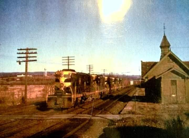 |
| Chester Historical Society photo |
Two years later it merged with other lines
to become part of the Lehigh and Hudson River Railway. |
| John Barriger III photo |
To look at Greycourt today, one would never think it ever amounted to anything.
When I went over the plan with Bob, I let him know that I had already walked most of the line, but never any of it east of the Moodna Viaduct, so it was very important for me to reach the Vails Gate area where it joined with the "Erie Shortcut" to Woodbury area, which as I understand was at one time treated as part of the Newburgh Branch. Although both branches were double tracked, it was like it was a double tracked line. |
| Dennis Carpenter photo |
Bob suggested we start the hike at Chester Station because there wasn't good parking anywhere else. I thought we could have done it at Greycourt, but I don't know the parking situation there well, and Chester really isn't much farther.
We parked right at the station and did our group shot there.I was glad that Bob's presence and the fact that this line would soon not be the same brought out more people. It was cool to see the groups growing again. |
| 1880s Chester Historical Society |
The Chester Station is a handsome structure built in 1915 to replace the original one from the 1830s construction of the old Erie main.
We started with our group circle, and Bob gave us a great little dissertation about the history of the area. The old Erie main and the Newburgh Branch were amazingly ripped up at about the same time, which surprises me.We started our hike on the easy, paved Orange Heritage Trail and Long Path, which follow the old Erie main now from Harriman to Middletown. This was all very nice and easy with the stroller.
We continued to Greycourt and passed beneath the plate girder bridge that carries the former Lehigh and Hudson River Railway over top, and ahead there are tracks coming in. A siding comes from the far side of the bridge and a section of the old Greycourt yard is still used by the modern rail carrier for car storage.
We paused at this point because I had several then and now history compilations I wanted to get of the former station site. |
| 1910 postcard |
This time, Bob was right there with me to confirm where the station used to be. I had been to this spot several times before, but I never could figure out the exact location.I had photos saved to my phone from various different angles, and from different photographers and different years.
We spent a good amount of time here, as I went back and forth and tried to set up every photo I could find of the historic station site. Meanwhile, some of the group continueda head a bit.
There is a path that crosses the main trail in this area that in railroad days used to be a grade crossing, so that was used as our anchor point to the past in several photos.
Just behind the station and freight house area was the former site of the Diffily Hotel or Diffily Inn. The site was owned by John Diffily who also served as postmaster at Greycourt.  |
| Russell Hallock photo, probably around 1980 |
At some point, the large establishment tragically burned. One of the historic images I was attempting to get a now photo of featured the burned out shell of the Diffily hotel in the background, but I do not know exactly what date this happened.After a lot of running around and photographing, we continued on ahead along the still used bit of rail siding on the right. Bob commented as we went by here that there is no blockage at the end of it because it was kind of uphill, and that it would take a great amount of push to get any cars out to the end.
Russ and Ewa continued ahead for a bit because they planned to walk the east end of the wye where the Newburgh Branch broke off.
The site of the junction was on the left, and quite obscure. It would be easy to miss for those not knowing what they were looking for.
We all turned onto the right of way and almost immediately crossed over the first of many undecked bridges on this line. This one was over the Seely Brook.
We continued ahead and skirted a chain link fence. This, I assume, was probably something keeping the tracks and right of way separated from the Camp LaGuardia facility.
The camp was built in 1918 as a women's prison I always understood, but Bob explained it that it was more of a farming community for troubled women. At the time of World War I, likely with most the men away, crimes among women were reportedly going up, and so the call was made for the development of Camp Laguardia. The first women arrived from New York, City in the early twenties.
By the early thirties, there were less crimes among women, and so it was transformed to a camp for the homeless. It lasted without incident pretty much until the 1980s when the property was sold to Orange County. It remains in limbo today, abandoned on the hillside, and many don't even know it's there.
We continued ahead on the right of way, and came to an old grade crossing. We turned right here only briefly to check out the old cemetery. The road continues to Camp Laguardia, but we wouldn't be going that far.
The cemetery certainly predates the camp, because there are graves there that date back to the American Revolution. We paused the group there and Bob did a little dissertation about the cemetery, and we both talked to the group about the history of Camp Laguardia.
From here, we continued north and soon came to the first concrete mile marker with a "G" on it, and a 1, for a mile out of Greycourt.
Throughout the course of the hike, Bob would point out where all of the mile markers were along the way.
He even gave me a copy of one of his books to refer to during the hike, but moving along and pushing the stroller, I rarely had the opportunity to review it. I would be reading into it while writing this journal entry now, but the problem is it got lost in the mounds of books during remodeling at my house, so it'll have to wait for a return trip.
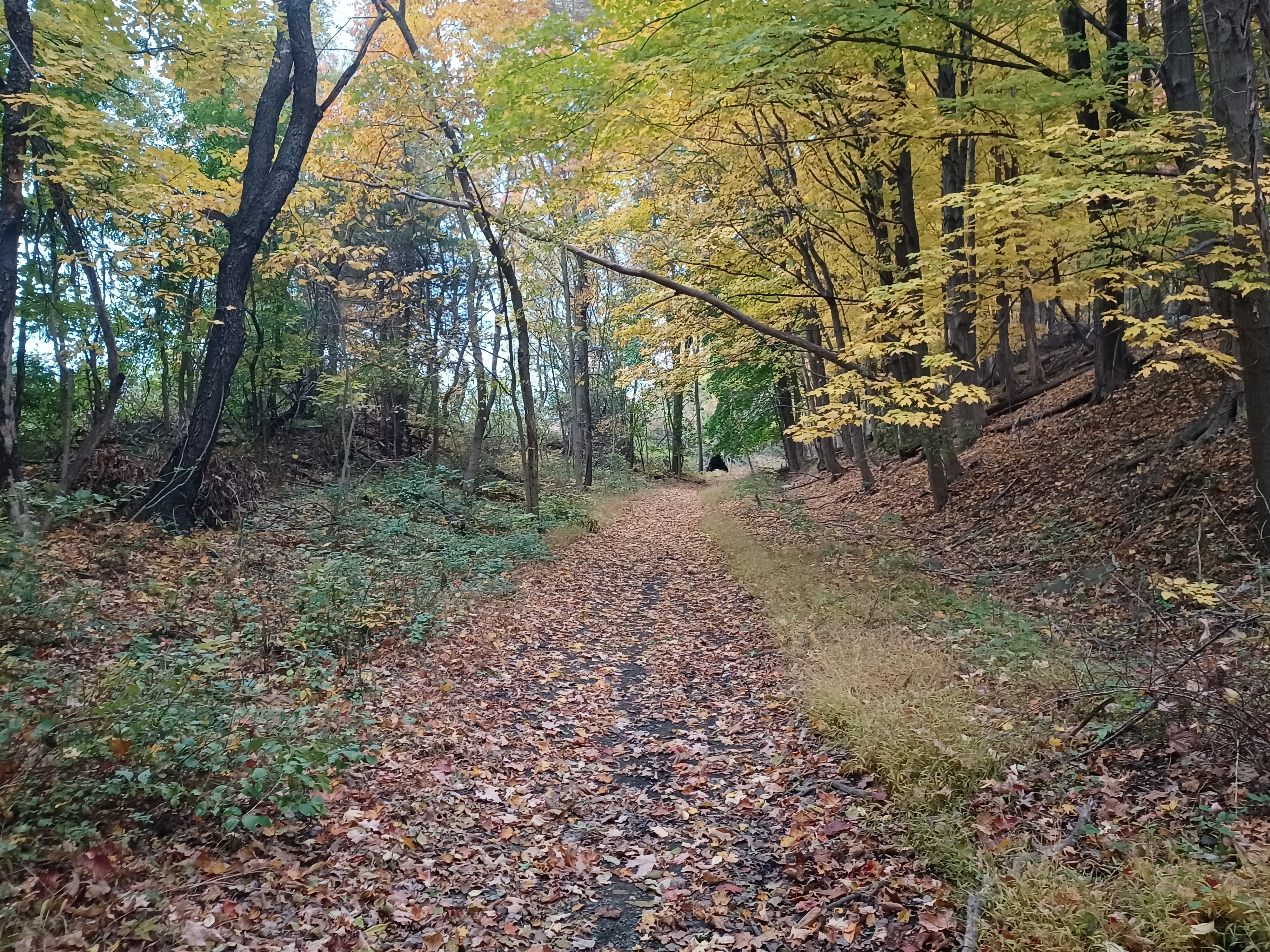
The foliage was just about perfect for this hike. I don't think we could have chosen a better route for this particular time of year.
Just ahead, we came upon a tree that had a transmission up in it, which is a really very oddball thing. I'm talking a vehicle transmission. Up in the tree. A GM TH 350 automatic transmission.
This is a really heavy piece of equipment to have just ended up six or seven feet into a tree.
I posted the photo on Metrotrails, and I got a never ending list of one liner jokes on it, including "I don't give a shift", "a turbo TREE fiddy", "a map to the trans world", "human stupidity is highly TRANSmissible", "They decided to stick it to that tree", "three on the tree", "I wonder what that tree identifies as", "shade tree mechanic" and so much more.
We continued through pleasant woods ahead, and came to our first road crossing, Craigville Road. There was apparently once a Craigville Station, but I don't think I've ever seen a photo of it.
The right of way was a bit obliterated here, but the crossing was the first one where there was actually a sign referring to the right of way as a trail. It said it was entering private property and to remain on the trail.
We had to go left and then right up a slope in order to return to the rail bed. There were some woops and giant puddles, but once we were past that, the rail bed got to be easy walking again.
Tina really hit it off with little Ev. She rode to the start in my car and talked to him the entire way. He smiled and laughed almost non stop. She loves children and was once an obgyn, so she knows children very well. She pushed the stroller for me for a while, and was very anxious to do so. Even when I wanted to push it, she was off with him!
There was another nice long section of woods ahead, and we went through a pleasant cut, then crossed over Rt 94. This was probably the only decked bridge of all of them on the line.
It was a through plate girder bridge of what looked to be quite serious construction. Certainly, this was not the original bridge at this location, which is part of the reason.
94 had been upgraded over the years, and it merited a larger underpass. Maybe prior to the upgrade, it might have been a grade crossing.
We continued through more woods ahead of this point, and I walked and talked for a bit with one of the newcomers, Robert Farrell.
This guy was really cool. He used to live in Clinton right on the shore of Spruce Run Reservoir, but work moved him up to Westchester County on another project, and he now lives up along the west side of the Hudson.
Rob is basically doing the same kind of thing as I do, connecting all sorts of hikes together, although he's not doing all of the same types of things as me.
I find most anything of interest, where he focuses more on formal trails and such, but does it at a greater volume than most anyone I know of.
He said he only joins group hikes when it looks like something he couldn't do on his own, and this was one of those opportunities to get out on something he'd not considered doing before. He was a really cool connection to make, and it looks like he'll be joining us again in the future.
The rail bed passed through some very nice rock cuts and deep woods ahead, and before we knew it, we were passing by a concrete mile marker denoting 4 miles out of Greycourt.
I hadn't seen any of the posts prior to this one, and I'm not sure if any of those ones exist, but if they do, Bob knows about it.
I got to walk with him a bit as well, but he did hang back with the rest of the group a bit. I tried to keep myself between front and middle.
Bob and I have something closely in common, where my big line growing up was the old Lackawanna main line in Warren County NJ, his big thing was the Newburgh Branch.
He's done better than me with publishing books on it, and the Newburgh Branch is certainly less truncated, but it will be a formal trail all the way through before the Lackawanna will be.
Pretty soon, we came to a beautiful wetland on the right side of the right of way.
Peering through the trees at the pretty wetland revealed a beaver lodge sticking up in the middle of it.
We continued ahead with more good views to the right, and the came out to cross Farmingdale Road. It was back into deep woods again on the other side. I don't know if there was ever a flag stop or anything at that location, but Bob would probably know.
We continued through the woods, and soon came to a power line crossing. The line, like many of them we come across, was in the process of going through an upgrade.
One of the old iron lady style towers was laying on the ground, while new ones were being erected and wooden platforms had been placed for equipment to drive around on.
We continued through woods and came out to and crossed Tuthill Road. Either here or at Farmingdale Road there must have been a station, because I know I have seen photographs of Blooming Grove Station, and we were just barely to the southeast of Blooming Grove. I was too far ahead of Bob to realize it this time, but hopefully another time.
From Tuthill Road, the right of way passed through a mix of woods and followed tree lines with fields on either side. It was another really beautiful section with little cuts and fields as we neared the valley of the Moodna Creek, which we'd follow for the majority of the rest of the branch.
Heshi came all the way up from Philly, and I mentioned to him at the start that this was going to be turned into a trail soon, so it was much like the last time he was out with me, where we hiked Lehigh Valley Railroad where it hadn't been quite developed yet. Heshi is working on a program where there will be a street view on trails similar to what is done on Google Earth. He's pretty resourceful so he may make something of it, but even if he doesn't he might be able to make some money selling such an in depth record of the entire line. He went way ahead of the group recording this.
When I finally caught up with Heshi again, he was at a major washout in the right of way.
Ahead, the first crossing of the Moodna Creek was a deck girder bridge, but the right of way leading to it was majorly washed out. I don't think it had been this past the last time I was out there.
There was definitely no getting a stroller through the mess ahead. We would have to figure out some way of carrying it on through.
Heshi waited for us when we got to the mess, and he helped me to start carrying Ev in the stroller through it all. We made it across the first section of deep rut, but then it was just getting too ridiculous to pass. We would have to try another route.
To the right, there was a steep ATV path down to the bottom of the high fill, and then another one further on up that went back up to the rail grade after the ruts and washout. I pushed Ev down that pretty easily, but when it came time to go back up, I needed all the help I could get. It was super steep.
I stayed behind the stroller, while Heshy went up front, held the wheel and tried to direct a bit.
The rest of the group moved on through the rough stuff that we couldn't get through, and they got together at the top to help get the stroller up to more level ground.
The team effort made it happen and we were good.
It seems that the Moodna Creek had flowed over and backed up behind the bridge at times, and purged through the fill from behind the railroad that acted as a dam.
At the approach to the bridge, even some of the earth around the edge of the south abutment was washed away.
The bridge was an open deck. We had to carefully step across on the railroad ties between which we could look right down to the creek. A lot of people have trouble with these types of bridges, but I'm fine with it.
With a stroller, it is far more difficult than usual. The ties are close together so I can sort of bump the wheels across, but I still needed someone on the front of the stroller to help move it along. Tina came up and helped with that and we got him across. Ev looked curiously out to the river on either side, but didn't show any signs of being scared.
Bob told us I think that this was referred to as the "Tin Bridge", but I don't quite remember why he said that!
This bridge was the highest of all of them we'd cross, which is probably why the ties were in such better shape.
The mist off of the creek on the lower bridges probably leads to the rotting of the wood far faster.
Once on the other side, we soon paralleled the fields of the Washigtonville High School.
 |
| Russell Hallock photo |
The right of way brought us out to Rt 94 again, West Main Street. Directly across, the railroad bed was fenced. I didn't remember it being this way the last time I'd walked it a couple of years ago.
In order to get through, we turned left on the road for a bit, and at the first opportunity, turned to the right out behind the Blooming Grove Central Garage where we could see a bit of a path slightly ascending to the rail bed again.
We turned left on the rail bed just a short distance and soon came to the next bridge over the Moodna Creek.
The though plate girder bridge was in deplorable shape. The superstructure was fine, but the ties were missing over much of it, and there previously had been walkways made of pallets and other bits of wood.
 |
| 1950s |
We had a very easy time crossing it the last time we were out there because of how it was decked, but flooding damaged it pretty badly.
The walkways were still sitting on the bridge, but all sort of off where they should be.
I went out into the middle of the bridge to see if there was any reasonable way at all of carrying the stroller over the first pile of wood, but there definitely wasn't. I would send the intrepid members of the group over it, while I'd go out and around with Bob, Russ, Ewa and a few others.
We went back the way we came, out around the garage, and onto West Main Street into downtown Washingtonville.
The settlement was originally known as Little York, then Matthew's Field, and finally Washingtonville in 1818. The settlement grew much more with the arrival of the railroad.
We had hiked through Washingtonville a couple of times before, the first time with a trip to the Brotherhood Winery.
We continued through town to the intersection with South Street, and turned right there to soon cross the Moodna Creek on the road bridge.
Just a bit beyond, we turned to the right on Depot Street which just sort of skirts a strip mall parking lot. The plan was that we would have lunch the same place we did on the last trip out there, at La Villa Mexican Restaurant because we liked it the first time.
 |
Bob McCue Collection
|
We all sat down at the sort of outdoor seating, but it was now enclosed somewhat from the last time we'd been there.
 |
| Bob McCue collection |
We basically took up an entire side of the outdoor area, and so I was able to let Ev out of his stroller to walk around holding on to people's chairs, which made him quite happy.
 |
| Russ Hallock photo |
I had to pee really bad, and we had been out in the open too long to take care of it before, so I went to use the restroom like three times and there was still someone in there blowing mud for an eternity.
 |
| 1964 Dennis Carpenter |
I couldn't wait, and there was only the one room, so I decided I would go out in back of the building and left Ev with Tina.
 |
| Probably Dennis Carpenter, 1964 |
While I was back there, it was also the perfect opportunity to set up more then and now history compilations. I had a ton of them of Washingtonville saved to my phone, so I got a ton of them.
There were several from Bob's collection, some 1950s and 60s ones, and some old postcard ones.
I had a pretty good idea of where the station was at this point because there is a loft area of one feed building back there still in place from the historic photos. It is the only building left back there that serves as an anchor point to the past.
I got four or five of the compilations and then headed back to the others in the restaurant.
The food was just great. I got Ev to eat some rice and such, but he wasn't much into eating anything at this time. I'd been bringing sticks of cheese, and the little round wax covered cheese which he likes to munch on, as well as those little squeeze packs of apple sauce variations with other fruits, so he's having healthy stuff at least.
 |
| J. E. Bailey photo from Jim Hutzler Collection/Steamtown NHS archive |
I felt adequately stuff and had an IPA, so everything was all good.
When everyone was finished, we headed back out and behind the building to the old station site where Bob told us a little about the history of it.
The was a passenger station and a freight depot in close proximity in an open area where it used to be possible to see all the way to the next bridge over the Moodna Creek, a through truss structure.
A path led through the weedy area where the buildings were and into the woods to continue on the right of way similar to just before we got to Washingtonville.
We continued ahead on the right of way and soon reached the crossing of the Moodna Creek and the through truss bridge.
Bob explained that this bridge was ahead of its time when it was built, as an earlier example of a more modern truss design, which is why it lasted for so long. This bridge was built by the Erie in 1871, and at wider dimensions than we usually see in these bridges, because it was built when the Erie was still utilizing broad gauge.
We managed to get across it rather easily, even with the stroller, and Tina helped me again with it.
On the other side, she pushed the stroller for a while and I took turns talking to the rail fan friends about the history along the line.
I think the previous bridge was called the Nicoll Bridge and maybe for the next street we were crossing, Nicoll Street.
The right of way took us across the street, behid homes on the left, and behind industry on the right.
We crossed Locust Street, continued behind more houses, and then past the sewage treatment plant. Beyond that, we were out in much prettier farm land some views of the end of the Schunemunk Ridge in the distance. We then passed another concrete mile marker denoting eight miles out of Greycourt.
A little further, we crossed the Fairview farm lane, and there was still an intact and used cattle underpass from when the railroad was in use.
Beyond that, we went into a cut, and there was an old upside-down car that has probably been there since the railroad was abandoned. It looked like they had rolled it from the fields above, probably goofing around.
We continued ahead, and soon reached the next crossing of the Moodna Creek.
This one was another plate girder structure, but a whole lot of the ties were missing. I knew the bridge closer to Salisbury Mills was in pretty bad shape, and it would be hard to get the stroller across, but maybe even harder to go over a fence on the other side like I had to do the last time I was out there.
I told the rest of the group that they could continue over the bridges, but I already had a plan on how I was going to get Ev over there.
There is a path that goes to the left from just before this bridge, and follows along the Moodna Creek for a bit. It then emerges behind the Weir's Ice Cream Stand.
I figured someone in the group would likely want to follow me that way. I think Russ and Ewa went around ahead of me. But no one else decided to go with me, and everyone crossed the two other bridges.
As everyone else was moving ahead, Ev and I descended and went along the very nice mowed trails that weave through the woods adjacent to the ice cream place. We emerged from there, and then cut through the adjacent parking lot to the right to reach Route 94. We turned right and followed it only a short bit, and then turned right on Orr's Mills Road. It was a bit narrow, but not too terrible. We followed this right into the little settlement of Salisbury Mills.
I met up with some of the group when I reached the railroad bed crossing, which is barely discernible in downtown Salisbury Mills today. On the left side of the road, it is almost completely covered over with weeds and such.
I had the others watch Ev for a few moments while I backtracked to the bridge. They were rather shocked that I'd made it all the way around that quickly, and I was glad they were taking so long, because I had some then and now history compilations I wanted to set up at the last bridge.
 |
| 1963 Dennis Carpenter |
That second bridge was a through truss structure with an "X" configuration in the superstructure that looks really cool. Some of the group hadn't even reached the bridge yet when I got there, so I hopped fast speed across it back to the other side and set up two compilations shots, both of which came out great.
One was a very old postcard, while the other was a 1963 fan trip image.
Once everyone was across, Bob suggested that we might take a shortcut because the right of way could get so muddy ahead, but I was really into just continuing on it, and we did pretty well anyway.
At the intersection where the tracks crossed through the middle of the town was the "Soldiers Monument" as it is referred locally.
The Blooming Grove War Memorial of Salisbury Mills is a 19 foot granite and bronze topped monument was completed in 1891 as a memorial to local veterans of the War of 1812 and Civil War. I had another compilation to set up of this site before moving on.
Salisbury Mills is named for the mills, for which the Moodna Creek is still dammed just downstream, and the reason it is so still through the section.
We passed the monument and followed Clove Road for only a short bit, and then turned right onto the railroad bed again.
Just ahead of this location was the former site of the Salisbury Mills station. I set up a couple of then and now compilations at this site also. The station site is barely recognizable at all today. Bob says there is an entrance off of the road over to the right to where the station used to stand. One would never be able to tell today.
We continued back into the woods, and the treadway was not nearly as muddy as I was expecting. It continued to get easier as we moved on ahead and crossed a driveway. We passed mile marker 10 in this area.
We were much closer to houses though this next bit, most of them down below us to the right, but it wasn't at all bad.
As we started reaching the farther east side of town, we approached the amazing Moodna Viaduct.
The magnificent bridge opened in 1909 on Erie Railroad's Graham Line, which was intended as a freight bypass to the Erie main, from Harriman on to the area of Guymard Turnpike on Shawangunk Ridge.
At 3,200 feet long and 193 for high at its its highest, it is the longest and tallest railroad trestle east of the Mississippi, especially since the destruction of the Kinzua Viaduct in Pennsylvania.
This section of the Newburgh Branch we had been walking was once considered part of the Long Path, as was the Moodna Viaduct, but opinions on walking along active railways have changed over the years, and they've even closed the grade crossings where these major trails had passed for decades further to the south. |
| Russ Hallock 1969 |
Years ago, a few of us ran across the Moodna Viaduct after we knew a train had just passed, very drunk off of Brotherhood wine. I was glad that we got away with doing it because we'll probably never get the chance again.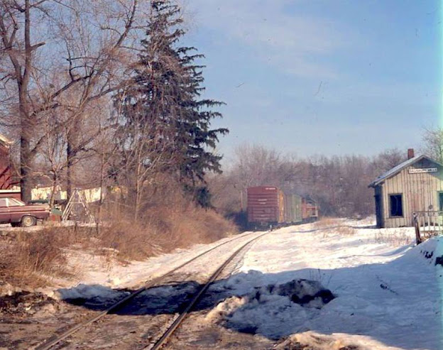 |
| 1971 Russ Hallock |
I had a few historic photos of this site as well, which I set up history compilations with again.
We re-grouped at the viaduct so that Bob could talk about some of the history again before moving on.
We were joined at lunch time by one of Mr. Farrell's friends, I can't currently remember his name, and he walked with me and told me he had walked all of the line above where we were, but he'd never done any of this section, so was keen on joining the group for that, so it was nice talking to him about everything he'd seen. He and others who hadn't seen it before were really blown away that there was a baby out on this hike.
Up until the viaduct, we were still pretty close to Orrs Mills Road, but from there, it turned away from it to the north.
The bigger deal for me at this point was the fact that I'd already walked the entire Newburgh Branch southwest of this point, but I'd never walked any of it further. I was very happy to have reached the point of stuff I'd never seen before.
I think except for Russ and Ewa who got really far ahead in this area, the entire remainder of the group stayed behind at the viaduct for a bit. Diane and I continued ahead.
This section was incredibly pleasant. We curved away and through a cut as we moved off from the Moodna Creek valley. We skirted some pretty farm land and wet onto a higher fill where the brush and such was encroaching more heavily on the right of way. Burning bush was growing in, which made for a pretty crimson ambiance.
Pretty soon we reached Jackson Avenue, where there used to be a bridge carrying the railroad over top. We had to go down steeply, and then climb back up the other side.
Our new friend we met at Washingtonville was getting picked up at this point, shook my hand, and indicated how much a good time he'd had.
Bob tells us that this bridge site had stone abutments in place, but that they were removed and re-used for a foundation and for a few other things, but I can't quite remember what else he said happened to them.We continued on the other side, and I all of a sudden realized that this had been the very last road crossing we would reach before getting to Vails Gate. It was quite a good stretch of woods between there and that point, then we'd have a bit of road walk to the cars. Off to the left of the right of way, there were beautiful fields and foliage views.
At some point, I didn't know what was coming up and figured we had better wait up for Bob.
I didn't think it was possible to continue through on the railroad bed all the way to Vails Gate, and assumed we would be cutting uphill to the left to come out at the Cornwall Central High School.
Bob caught up to Diane and I with the rest of the group, and we continued on as the right of way shifted from southeast to east to northeast to north.
On the shift to the north, we passed through a more dramatic cut. Bob said that we were lucky; usually this cut is full of water but we made it through really pretty dry.
As we left the cuts and continued north, we soon came to the last bridge of the day, which crossed the former New York, Ontario, and Western Railroad.
This line was one that I'd explored to a very great extent, both main line and branches, over the years.
It began in 1868 as the New York and Owego Midland Railroad, the brainchild of DeWitt Littlejohn, who envisioned a railroad connecting New York City with Lake Ontario.
The line opened in 1873, but at the time, connection to New York City was by way of the Middletown and Unionville Railroad from Middletown, down into New Jersey, and then out the NJ Midland on what later became the New York, Susquehanna, and Western. The "O&W" as it is commonly referred, inherited the line in 1880, and this line we were crossing was developed to improve the route from Middletown to Cornwall-On-Hudson, from which point trackage rights were obtained on the West Shore Railroad down to Weehawken.
Many claim this line should never have been built; it overcame crazy elevation of the southern Catskill Mountains, and pierced through the Shawangunk Ridge. It had so many curves it was crazy. Even in its heyday, it was called the "Old Woman" or the "Old and Weary".
Many claim the O&W should have never been built at all, but it managed 541 miles.
It struggled right from the start, and up to the end. This is why the O&W was the first major railroad in American history to abandoned entirely in one day, March 26th, 1957.
The right of way of the O&W looked clear both east and westbound from where we crossed it. I would love to walk the section, but the pieces of it in either direction don't look too promising when it comes to being able to follow them.
I had been working on hiking all of the railroad beds in Orange, Putnam, and Ulster Counties that I'd let slip by over the past couple fo years, and the trips had been great, but now with little Ev out with me every week, some of those hikes will not be so amenable to strollers. I'll have to hold off until he can walk it all with me before I can revisit all of them, and the O&W is definitely far too overgrown in spots to do with him.
The bridge carrying the Newburgh Branch over the O&W was built double width just in case they ever decided to double track the line.
We continued from here along the Newburgh Branch and curved to the left slightly. We were heading north at this point, and pretty soon there were some side trails coming in from the left. These were apparently Cross Country Team trails used by the high school.
The group was pretty much together at this point, and I asked Bob if we weren't going ot head up there, because I didn't think we could get through.
He assured me we didn't need to get off of the rail bed. We could follow it all the way through to Rt 94!
I was elated to find out that the entire railroad bed was going to be accessible to us to Vails Gate.
The wooded stretch getting closer to the end was really lovely. The sun was going down, and it kept getting darker, but we managed to get through the entire section before the last light was gone.
Just before coming out to the road, there was a chain link fence before Rt 94. Fortunately, the fence was open enough that we could walk through and the stroller would fit.
The road was not the junction site with the "Erie Shortcut". The right of way continues on the other side and is now severed by the NY Thru Way. Bob said that there was actually a bridge that brought the railroad beneath the Thru Way, but that it had been filled in at the first opportunity they had! I wonder if that bridge still exists and could be used when they go for this trail plan, but there were probably highway upgrades since that might be prohibitive.
Bob also said that he questions whether the trail would be allowed to go along the back of the high school because the board of education seems to have a problem with it being back there, but to me that is kind of ridiculous.
It is always the initiative to have more pedestrian friendly routes, especially close to schools.
The original junction spot is just a bit to the north, and we never went to that spot because it was getting dark and would be out of the way. Hopefully on a future trip. The Erie Shortcut down from this point is going to be difficult to follow as well, because it goes through brush, the Storm King Arts Center, and crosses the Thru Way at grade. It'll be a tough go with a stroller, so that part will wait. The rest of the route up into Newburgh is also tracked, so going through on that with the stroller will also be too difficult.
We turned right on Rt 94, and I walked close to and talked with Bob. It was a good final bit to the hike, talking with him about the parallels of our lives, walking these lines and learning more about them than just about anyone.
We passed beneath the Thru Way on the road, and then crossed the Erie Shortcut with tracks. There were still tracks going to the south, but they were badly overgrown, and to the north they were clear. I think there used to be a station shelter or something at this crossing, but I can't remember for sure.
The area of Vails Gate is a neighborhood of New Windsor, and is named for John D. Vail, who was a former postmaster and keeper of the Blooming Grove Turnpike toll gate. In fact, prior to Vail having that position, the area was known as Tooker's Gate for his predecessor.
We continued walking to the east and came close to Rt 32. There, we cut to the right slightly through a gas station parking lot, then direclty across 32. I got a bit of a running start, and then pushed Ev up the hill steeply to the back of the Hanneford store parking lot where all of our cars were.
It was totally dark out at this time, but didn't matter with all of the light from stores and businesses all around, and it was unseasonably warm out.
I took Ev out of the stroller and let him crawl all around me in this area of the parking lot where there was no one, and Justin headed back to the start to bring my car back, which is how we have to do things with the baby and the car seat.
Kirk hung out with me in the parking lot until Justin came back. Justin had ridden up with me from Mt Olive, so it worked out pretty well.
This had been a really fantastic day on one of the best routes we could have chosen to do.
I'll definitely have to do it again after the trail gets developed to see the differences, and I'm glad we got to do it all one more time on such a perfect day before any of that happens.


.jpg)


An excellent hike and excellent summary!
ReplyDelete