Hike #1510; 10/16/22 Ogden Mine Railroad; Ogden/Edison to Wharton with Kirk Rohn, Jon Wilson, Justin Gurbisz, Robin Deitz, April Hamilton, Stephen Argentina, Kenny Zaruni, Brittany Weider, Diane Reider, Gregory Andres, and Everen
This next hike would be one that I planned specifically because I believe it would be something I could get my son through with relative ease.
I had hiked the Ogden Mine Railroad through on this route once
before, back in November of 2006. On that one, we did some of the more rugged
stuff and traced the right of way really very closely to the Sandy Point bit of
Lake Hopatcong. From there, I didn’t know at the time where it went, so we
walked roads, and then got on the last bit in Berkshire Valley Wildlife
Management Area.
Since I’d never walked the mid section to Nolan’s Point, some of this hike
would be new to me. I planned also on tacking on the Morris Canal in Hugh Force
Park, Wharton NJ. The lock house there had been recently reconstructed, and I
wanted to see that too.
It looked like we had a pretty great hike in store.
Like so many of my favorite routes, the Ogden Mine Railroad is
one that had faded into obscurity during much of the initial rails to trails
movement. These days, it looked to be just a spur line that went to some mines,
and is somewhat understandably looked at as something not so substantial. Just
like its right of way that is now cut up, so is the information about its
origins and purpose.
My plan was to hike the line from the Edison/Ogden mines, north to south. After meeting at Hugh Force Park, we shuttled in as few vehicles as possible to the north where we would begin walking from Edison Avenue, uphill from the town of Ogdensburg.
I parked at what I believe was about the same location I parked
when I’d done the hike in the past.
Edison facility
These mines didn’t start at the time of the railroad like many others do. These actually dated back to the American Revolution, and the ore was carried out by wagon road.
It is believed that some of the railroad
utilized the improved wagon road route to the south.
The Ogden Mine Railroad was chartered in the early 1860s, mostly
by men from the Lehigh Valley PA. The most notable involved was Ario Pardee,
who was much more involved with the coal industry, but also many other
businesses including locomotive works in Hazletown PA. In fact, his works
constructed the two locomotives used on the Ogden Mine Railroad during the time
it was an independent entity. Pardee was also the silent but generous
benefactor of Lafayette College.
Edison facility
The original Ogden Mine Railroad did not connect with any other line. It traveled from the mines south to Nolan’s Point on Lake Hopatcong where ore could be loaded directly onto Morris Canal boats.
The canal connected to
Lake Hopatcong, which served as the canal’s main feeder, by way of a spur
canal. The main route passed south of the lake through present day Landing and
then Shippenport.
The charter allowed for the railroad to make connection to the
Morris and Essex Railroad to the south as well, but in the beginning it relied
on navigation to move product. As such, the railroad only operated the same as
the canal, about eight months out of the year. The canal froze in the Winter,
and could not be used. 
Edison site from Lowenthan's "Iron Mine Railroads of Northern NJ"
When loaded, the boats were pulled by a steam tug across the lake to the Brooklyn Lock at what is now Hopatcong State Park, and carried into the main Morris Canal. It was likely the smallest railroad in the world to have a marine department.
The tug was brought to Lake Hopatcong by traveling up the Delaware Canal to
Easton, across the Delaware, and then by way of the Morris Canal.
Another problem with being disconnected from the rest of the railroad system
was that the line had to perform all of its maintenance sort of “in house”. It
had to have its own engine house, work crews, and other buildings.
Like most lines, it was inevitable that it would be absorbed
into one of the larger monster railroad lines. 
Edison's site after being vacated
The Delaware, Lackawanna, and Western Railroad, who at this point controlled the Morris and Essex, had interest in purchasing the Ogden Mine Railroad, but the Central Railroad of New Jersey beat them to it.
The CNJ had completed the High Bridge Branch as far as Wharton
in 1876, and so they leased the Ogden Mine Railroad for 999 years in November
of 1881, and took control January the following year.
1866 Pardee engine, used till 1893
The proposed extension south, under the name Lake Hopatcong Railroad, was
completed by the CNJ in 1882. The extension made its way south from Nolan’s
Point and sometimes had grades that exceeded 3%. It then connected with the
High Bridge Branch down near present day Hugh Force Park and Lake Junction.
When the iron industry dwindled, the tourism industry flourished. Nolan’s Point really started as a little railroad town, but soon became a major tourist haven. Hotels and amusements were constructed and as many as sixty thousand patrons every Summer rode the line to vacation on the shore of Lake Hopatcong.
Still, even this was short lived. The automobile came, and the railroad went. Passenger service on the line ended in 1923, and freight continued just over ten more years.
Operations on the northern end of the line
above Nolan’s Point stopped about 1935. Although operational abandonment was
approved for all of the line, some trains still traveled to Nolan’s Point, and
some excursions may have continued until as late as 1938.
Full abandonment was approved, and the line was scrapped in 1941 for about six
thousand dollars. It seems disproportionately horrible that the line that
carried 100,000 tons of iron ore over those rails annually should be scrapped
for such a small amount.
The line faded into obscurity, and all around Nolan’s Point it was incorporated into the road system or built over by newer homes taking advantage of the already level areas.
Bits and pieces were preserved through
Sparta Mountain Wildlife Management Area, Weldon Brook Wildlife Management
Area, Mahlon Dickerson Reservation, and Berkshire Valley Wildlife Management
Area. The only portion of this entire amazing line officially recognized as a “trail”,
is the bit in Mahlon Dickerson.
The place we
started was historically called “Ogden” until Thomas Edison came in and brought
new hope to the failing workds.
When more accessible iron was found in the Midwest in the 1890s, Edison was
inspired to re-establish the industry in the northeast.
A new process of
crushing and separating ore was implemented, but never really successful.
By 1900, Edison had vacated his new namesake site
to focus efforts cement initiatives in Stewartsville.
Today, the Edison site is part of Edison Bog
Preserve and Hamburg Mountain Wildlife Management Area. The Highlands Trail,
Audubon Society trails, and the Ogden Mine Railroad bed and associated tramways
can all be hiked here today, but we were going to try to just stick with the
railroad bed as best we could.
We started by walking beyond a gate at the parking area. It didn’t look to be the railroad bed yet, but it could have been a tramway or something. It brought us through woods and out to a utility clearing where we could see some ruins.
Edison’s buildings were immense through this area, but were gone soon after he vacated the site as I understand.
We passed by the edges of some mines after
crossing the clearing, and I watched carefully to be sure I was holding well
onto the jogger stroller. It was kind of tough going through some of this
trail, but I figured the railroad bed would be far easier to follow.
We ended up coming out behind a monument giving the history of the area with a photo of Edison on the front of it, at another parking area. The railroad bed used to cut from this location parallel with Edison Ave, which I had intended we would walk.
Unfortunately, this route was badly grown over since the last time I had tried to follow it.
Getting through it with the stroller would have taken an hour just to do this short stretch. Edison Ave barely has any traffic on it anyway, so I decided we would just walk that section of road instead.
There were
visible ruins through this area, most notably a large stone base jutting out
toward the road. Just past that point, we could see the former grade crossing
where the Ogden Mine Railroad continued to the south.
I was disappointed to find that this section of the rail bed had also grown
over quite badly since the last time I walked it so many years ago.
Another odd thing was that none of this was marked as private when we walked it before.
The entire area up there is part of either Hamburg Mountain Wildlife
Management Area or Sparta Mountain Wildlife Management Area, but it seems that
the railroad bed might be exempted because there were signs along it. Maps show
that all of the area around it was public however.
Some of those signs were facing into public land, so I really don’t know what
to think. We just continued through and if someone told us not to be there, we’d
step a few feet over and get on the WMA land.
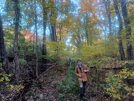
There were a lot of branches down over this, and fortunately the group was all right there to help me lift the stroller over whenever it got to be a little bit annoying to get through.
The foliage
was just about at peak through this area, so it was the perfect place to be
aside from the trees down. It wasn’t always bad, and there were good sections
where I could push the stroller through with no problem at all.
The line went over some very nice fills and through cuts through these deep
woods that made it really great.
There was not a sign of anyone else out there; we passed closer to some homes above us to the left as we started nearing some civilization, and I had the group wait up before we came out to a private driveway.
When I had hiked this before, we walked the private driveway out to Glen Road, which was built on top of the right of way, but I feel like things have changed now and I didn’t want to try to do that.
Above us and to the left, Edelweiss Lane passes by the Rock Island Lake Club. I
decided we would take a path up to that rather than chance having an issue with
one private land owner. It seemed that the road was public, but the club and
lake were private. At least if it was all private, we would be in a more common
private area rather than someone’s back yard.
There was a path that ascended a bit when we got near the road, and it came out
into a gravel parking area near Rock Island Lake. We made our way up, and then
quickly turned to the right to head out to Glen Road.
I got right
past the place and out to the edge of Glen Road. Apparently Stephen walked over
to the club and meandered between picnic tables and such. The lake was quite
pretty with a waterfall thing out in the middle, which I took a photo of
quickly, but I didn’t step beyond the road. A guy came out and hollered at
Stephen saying he was on private property and he moved off. We didn’t really
have any trouble beyond that.
Mahola Station by James J. Speer
Ken and I were up front, and we descended to where the railroad used to come out and cross the road. I waited there for everyone to catch up so I could point it out.
The right of way goes into a swath of woods, and then right along several back
yards along Glen Road, so we had to walk Glen Road for a bit.
The road bit
was pleasant enough, and not nearly as busy as I had thought it would be. We
headed downhill a bit, and we could see the railroad bed going onto a fill
behind the homes.
1940, Mahola, from Lowenthal's Iron Mine Railroads of Northern NJ
Soon, we reached the intersection with Milton Road where we had to turn left.
This brought us uphill past some nice springs on the left side, and to an
intact stone culvert underpass built in 1866. It’s really in great shape, and
hopefully will continue to remain there. I’m surprised it hasn’t been ripped
out citing some sort of bus, fire truck, or garbage truck clearance thing.
From this point, the right of way is in Weldon Brook Wildlife Management Area.
I set up a then and now history post on the site, and instructed the group to
climb to the top and begin walking the right of way.
The photo of the old bridge underpass that I used for the compilation is one that I have had saved to my cell phones longer than most anything I’d had saved before.
I think it’s been on there the third longest, so I was glad to finally
set this one up!
I would separate from the group and continue through the culvert on Milton
Road, and then turn right on Hayward Road to the next crossing because it would
be too much a hassle to push Ev up that slope in the stroller.
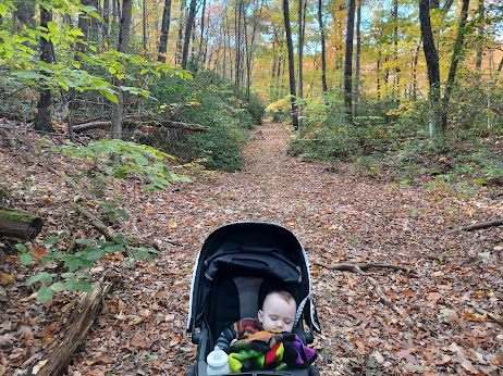
Ev had fallen asleep a little while earlier and the easy walking on the road kept him knocked out for a while.
I think he woke up around the culvert site and I talked to him as we pushed quickly to get back to the rest of the group.
As I peaked
the hill on Hayward Road, the group was trudging through the leaves about to
come out to the grade crossing. As I understand, this was the former site of
Mahola Station.
The station
building was just a small wooden shelter building along the tracks, nothing
particularly glorious, used by passengers in the early days.
We took a little break at this site, and went over some history and what was
coming up.
We continued through Weldon Brook Wildlife Management Area, and the going was much easier.
Although the surface was not totally level, it was way better than it was
before, and it would get easier as soon as we reached the Morris County
boundary and entered Mahlon Dickerson Reservation where it is formally
recognized as a trail.
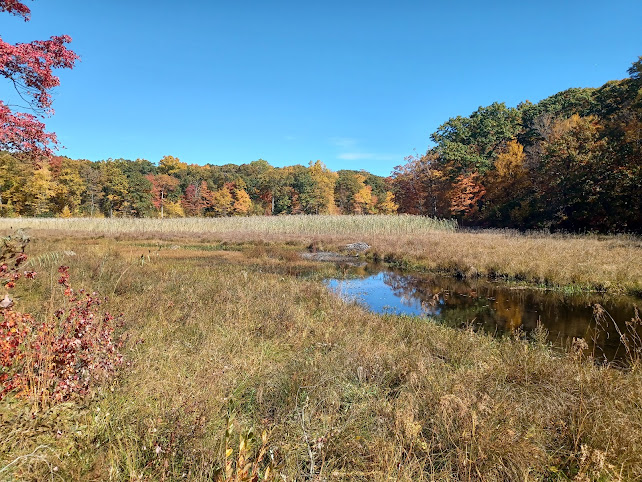
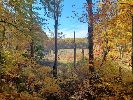
The sun started coming out more brightly which illuminated the leaves more than in the morning. The section passed through lovely woods, and afforded us views of pretty swamp lands on the head waters of the Weldon Brook. These are also the head waters of the Musconetcong River.
We soon seamlessly
entered Mahlon Dickerson, which at 3,494 acres, is the largest county park in
the Morris County system. The first segment of the park was acquired in 1960,
and named for an early NJ governor and Supreme Court Justice.
Fords Station, James J. Speer
The land here was also used for iron mines, and when we reached beautiful wetland meadows to the left, I looked for evidence of a spur that had led to the Ford, Hurd, and Schofield Mines that existed in the area. I didn’t notice anything in particular of where it had been.
At some point
Ken and his dog Scout and Greg and his dog Saga were walking side by side with
the stroller, and Ev looked back and forth very curiously at the two dogs
walking on either side of him.
We reached Weldon Road and parking area for the park, which I think is the former site of the Fords Station, another little wooden shelter station. I didn’t realize these two sites were the station sites before coming on this hike, and so I wasn’t able to set up my then and nows of them here, so once again I have to go back! Fortunately, road crossings are easy.
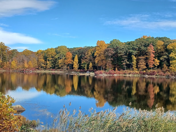
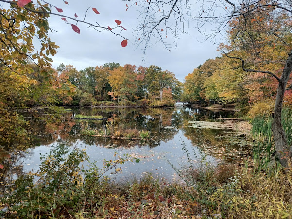
There were tons of people walking on this section of the line. The entire section goes very close to Saffin Pond, which is just gorgeous any time of year, but with the foliage, it was among the most beautiful sights on the entire hike.
Lots of people commented on how cute Ev was, and he smiled and giggled at just about everyone he saw through the stretch.
The views down along the lake kept getting better as we moved on.
At one point, Ken walked Scout down to the edge of the lake to get him a drink,
and Scout nearly pulled him in! Ken said there was one incident where Scout did
take him for a bath previously, not on this trip.
At the base
of Saffin Pond, there was a rather new looking bridge over the dam. We took a
little side trip and walked out onto it to get more commanding views of the
lake and foliage. A great break spot.
We continued
into more woods to the south, and the railroad bed got close to Weldon Road
after going over a nice fill. After a little while beside the road, the rail
bed turned to the right and is obliterated by Weldon Road, but a trail
continues on the east side of the road.
The last time we walked this, I went up and walked the road section, and then the right of way goes into a swath of woods on the west side of the road. It can be walked, though it is not totally clear, but bringing a stroller through on it would not be advisable. It ends up coming out at someone’s yard along Weldon Road to the south.
We instead continued to walk along this parallel trail. I think the railroad bed and this road were used as a previous alignment of Weldon Road or maybe an estate entrance because there are two sort of monument entrance things along the way we pass through.
The trail eventually came out to Weldon Road. The railroad bed was off to the right side of the road, and then shifted to the left near the present day power line crossing on the road.
We had to remain on the road through here because the
right of way goes into private land. It does follow on or close to some of the
development roads closer to Lake Shawnee to the east of us, but there was no
way of going through without backtracking and doing a rather senseless route.
We continued on Weldon Road to the south, and soon approached the bridge and on
ramps to Route 15.
This proved to be a somewhat difficult little spot for us. The bridge was under construction, and the entire left lane of it was closed off.
I had to quickly and carefully cross from the left side of the road to the
right in order to get across the bridge over 15. The rest of the group was way
ahead of me at this point, and so they were waiting in the grass on the other
side beneath a tree.
Rather than
continue walking the busy Espanong Road from this point, I chose to get into
the parallel development.
Venetian Drive below this point probably follows the railroad bed, but it is a
dead end road into private property, so we didn’t bother trying to walk that at
all.
At this point, we started following Woodlawn Terrace uphill a bit to the southwest to avoid traffic, and Yacht Club Drive continues on a level to the west.
It seems that this road is built on the three quarter mile long spur from the Ogden Mine Railroad that served a facility associated with Pennsylvania’s Glendon Ironworks on the lake, probably at the present site of Lake Forest Yacht Club.
We didn’t explore out this way, and instead just followed the road to the intersection with Ripplewood Drive and turned left.
This brought us to a lovely little pond inlet of Lake Hopatcong, known as Wild Pond.
We skirted
this through the grass and came back out to Espanong Road where we had to turn
right. In a short distance, we crossed a finger of Lake Hopatcong at Sandy
Point, where the Weldon Brook flowed down from Lake Shawnee.
To the left, I pointed out where the Ogden Mine Railroad used to cross this finger of the lake. When I walked this in 2006, the wooden footings of the bridge were much more in place than they are today. They were apparently removed to aid with navigation.
When we got to the other side, we could see where the railroad used to cross Espanong Road, and then went parallel with Brady Road to the right. We re-grouped here again.
Also in this area, there was a siding and a turntable on the line off to the
east, and the area was known as Callahan’s.
While
everyone was resting, I ran across to Chabon’s Discount Liquor to see if there
was anything particularly interesting I’d never tried before.
What I ended up finding was Gouden Carolus Christmas, which was one of those
Christmas stouts with all sorts of weird spices and such. It was pretty good,
but not really my favorite.
A lot of people love those busy Christmas stouts like Mad Elf and the like, but I can’t really get into them so much. I definitely prefer the bolder flavors.
These are good, but they’re just too busy.
We continued
walking Brady Road to East Shore Road. In this area, the railroad would have
turned away from Brady and continued closer to the shore.
I’m pretty
sure that the right of way followed what is today McNabb Road or Spring Road,
but those are dead ends to more private land, so we couldn’t follow that. 
Turntable at Callahan's
We had to turn right on Castle Rock Road that brought us further above those points.
I got far
behind the rest of the group again in this area because I kept watching below
for any sign of where the railroad used to be. This was definitely area where
they used the level grade to build new homes.
At one point, there was a turn and a steep slope where we would have to go up
hill, but Nolan’s Point Park Road was directly below us, with one of the homes
under some construction. I badly wanted to bushwhack down and get on Nolan’s
Point Park Road because that was definitely the railroad bed from that point,
but there was no good way of doing it, especially not with the stroller.
Kirk held back with me at this point looking at the issue, and he agreed we couldn’t.
We continued along the road to the intersection with Nolan’s Point Road where
the group was waiting, and we all turned right to begin heading down hill
toward the lake.
I set up
another then and now compilation at the approach on the road when I recognized
the background topography from the images in my “Iron Mine Railroads of
Northern New Jersey” book by Larry Lowenthal.
Through the historic images, I was able to determine what was were.
I had wanted to stop for lunch at the Jefferson House because I think that’s the most historic still-standing of the restaurants on Nolan’s Point, but it was closed when we got there.
We tried to figure out which one to go to
instead, and noted there was a concrete post that might have been railroad
related. Of course, the road through the edge of Nolan’s Point is all the
former railroad bed, and the old station was near this point.
The Windlass looked like it was the best option, and it happens to sit on the
site of the popular Allen’s Pavilion, which was one of the tourist destinations
along the railroad.
Brittany I think called ahead before we got there to get us reservations, and we were able to use a little of the time waiting to go out onto the docks and get some nice views of the lake.
People come through and park their boats at the docks to
stop and eat; quite an interesting lake culture of living and playing on the
lake, using their boats for transportation.
We were seated rather quickly at two tables pretty close to one another. I ordered a pasta dish that was quite good as well as an IPA. Ev was asleep much of the time, but he ate whatever I gave him when he was finally up.
This ended up being a really nice stop with a view over the water the entire time.
The Nolan's Point location was also home to an ice harvesting facility in the days before refrigeration. Ice would be cut from the lake and hauled south by train after the 1882 connection was made.
1925; Bahrs - Miterko collection
It is interesting to think that electrifying
the branch under Central Railroad of New Jersey management was considered
starting in the late 1800s, but nothing ever happened beyond a demonstration of a gas-electric doodlebug (short distance passenger engine) demonstration in 1925. 
Refrigerator car from Warren G Crater collection
Instead, passenger service was discontinued on the line. It had already been cut above Lake Hopatcong, but would then be cut to Nolan's Point.
I could just
picture back in the day, the two competing steam boat company boats, the “White
Line” and the “Black Line” trolling the waters with patrons to these locations.
Both of these lines picked up visitors at train stations and took them around
the lake.
Lake Hopatcong was originally two smaller lakes, and the Morris Canal was
envisioned during a fishing trip, utilizing these waters as the main source for
the canal, because they sat in the very center of the state. The lake was
dammed and enlarged, and the Morris Canal followed the Musconetcong and
Pohatcong watersheds to the west, and the Rockaway and Passaic watersheds mostly
to the east. It was completed through from Phillipsburg to Newark in 1824, and
extended to Jersey City by 1842.
We finished
our meals and were getting ready to go when my old friend Bobbi Landrock showed
up at the Windlass to say hi. I hadn’t seen her in a while, because she hadn’t
been on any hikes. The last time I had seen her was at Ray Cordts Sr’s memorial
service about a year prior.
Bobbi said that hopefully we would see her on a hike again soon.
Pretty soon
we were off again. We exited the Windlass, and I looked around for any signs of
where some of my historic photos of the area might have been taken. It is
really difficult to figure this area out today.
We started
heading around the point on the former railroad bed, and then the road ascended
a bit higher I believe than the railroad ever went. I set up what I believe is
an accurate then and now using an historic stereoscopic image around the bend.
We continued on to a sort of boat storage area, and google maps showed the Cove Road continued on to Ridgedale Road, but then all of a sudden it didn’t go through.
I’m pretty sure the farther end of this or at least right next to it is the former railroad bed.
We went on through anyway, behind some junk, and there was all sorts of sticks
and such piled up blocking the road off. We were able to walk through, and the
group helped me to lift Ev over the branches to get to the other side, which
was sort of a driveway off of the rest of Cove Road.
We went past one private house and then were on more obviously public road. The
house was built right about where the railroad used to be.
Historic Allen's Pavilion
Cove Road did take us to a ninety degree bend where just below was Stonehenge Road.
I would
have loved to bushwhack down from there to that road because at least part of
it is built over the railroad bed, but with the stroller it would have been a
real pain.
Instead, we took the ninety degree bend and walked up to Ridgedale. To the
right, I thought maybe we could cut through the woods at the end of Ridgedale
to get through, but that also looked awful.
Instead, we went west on Ridgedale, and then right, north on Mountain Shores Road to reach Nolan’s Point Road where we had been before the Windlass.
This was a
bit of an out of the way thing, but it was okay. We followed Nolan’s Point Road
east toward Espanong Road, and then turned right downhill on Bird Lane for a
short cut. It said no through traffic on the road, but I figured it was okay to
walk on, and it cut quite a corner we would have had to take if we went direct
all the way to Espanong. It also would not have been a safe stretch of road to
walk.
Warren B. Crater 1882
Just a little down from the intersection would have been where the railroad would have crossed. This would have been the 1882 Lake Hopatcong Railroad extension.
I could kind of see where I thought the level grade would have gone across the road here. Stonehenge Road came out on the right side, and it seemed to go in to the left. There is a public property back in there called Minnisink Park, which I have never explored before, and I know a portion of the right of way goes through it, but I didn’t think I could get through it with the stroller. It was also starting to get late and I wanted to get through Berkshire Valley Wildlife Management Area before dark. It turned out to be a very good thing we didn’t try to push through that piece.
We headed somewhat steeply ahead, and the road changed names to Minnisink Road. When we got near the top of a hill, a driveway on the left side is well graded enough to be recognized as the railroad bed.
Kirk was
running a bit behind the rest of us because he had to run out into the woods to
blow mud, but the rest of us turned to the right into the back of the Jefferson
Township Animal Pound. The railroad bed went right out behind this, and when I’d
walked it before, it took us clear, directly into the woods of the WMA land.
We walked
around a sort of salt building or something, the same as we did in 2006, but I
couldn’t find the rail bed. I went uphill a bit and we came to giant piles of
earth there. It looked like whatever access there had been, it was now cut off. 
Nolan's Point Station
I started feeling horrible thinking that this entire great section of right of way would be completely inaccessible.
The group started fanning out, up and down the hill in either direction looking for an access in to the site.
This worked out well for Kirk, because the entire group was heading back the way we came looking for an access when he was walking up.
Within the weeds, the
others found the right of way. It was before we got to the giant piles of
debris, and so grown in that it was not recognizable.
Despite having been grown
in so badly, we could still walk it. It didn’t have terrible trees all down
over it.
I managed to push Ev’s stroller through it without too much problem, and only had to go over or under a few branches. The line soon went into a significant cut, which had a few trees down, but we did manage to get over them alright.
Pretty soon after the
cut, we came upon some reprieve. An ATV path emerged from the hill to the right. 
Warren G Crater Collection near Nolan's Point
Apparently it is still accessible from the pound area, but from further up. The path comes down and joins the railroad bed to continue south through the property.
Although it was much bumpier than the stuff we had been walking earlier, it was
much easier.
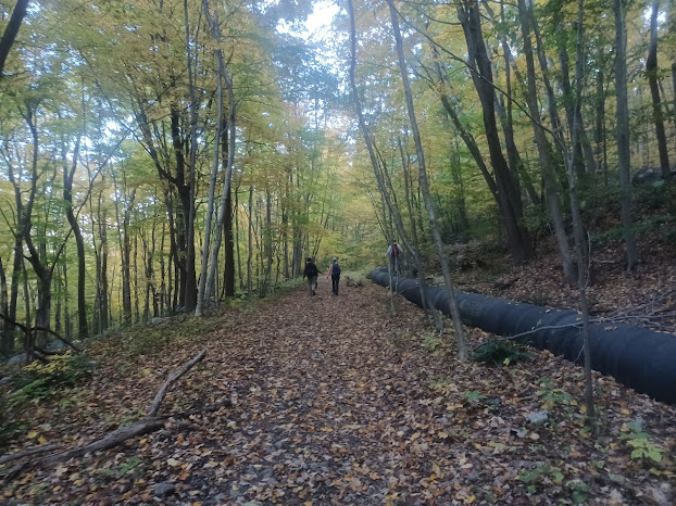
This section of right of
way is kind of odd because along the way is a giant pipleline, kept above
ground, to the right. When I first walked this, my brother and I walked on top
of the pipe almost the entire way.
Several in the group chose to do this as well, but I think only Justin walked
the top of it the entire way.
The branches in the way made it kind of hard to do it the entire time.
We continued on this
section, which was the part with the more than 3% grade. I honestly didn’t feel
it because the ground was so rough.
The sun was starting to
go down, and I didn’t know how much of the planned route would be feasible at
this point. I just wanted to get done with this wooded section as best we could
by dark and then adjust plans as necessary.
The right of way weaved around a bit, and we were often on a very high shelf. I suspect back in railroad days, there would have been a commanding view from the train up there, certainly something to add to the thrill of going for a vacation in the New Jersey Highlands.
Almost the entire section was in deep woods with barely any sight of civilization until we came close to houses at the south side of the WMA, but there was one house with a back yard that came close to the right of way.
At this house, we looked down to see at least four black bears hanging out and
probably easting something.
New Jersey has entirely
banned the bear hunt based on antiquated evidence that bears reproduce based on
stressed population, but most authorities agree today that they reproduce more
like deer, based on availability of food. Mothers would typically have one or
two cubs, but are now having four or five, and in one instance I’ve heard of
through my job, six! The state department of fish, game, and wildlife has
formally recommended to the Governor that the bear hunt be reinstated at least
to some degree, but he hasn’t budged on it. I really dislike the guy more and
more as time goes by.
I actually like bears, and I know people totally against the hunt, but their arguments are faulty.
They’ll claim we are stealing the land from the bears, but the more accurate
truth is we stole the land from the bears, they were eradicated from the area,
and now they are returning to a world that never existed before. We aren’t
going to kill off the people, so we need a sensible wildlife management
practice to cull the population.
Near the southern end of the Berkshire Valley WMA property, the pipeline disappeared and we were on just normal right of way.
At Gordon Road, I had to consider what the plan was going to be.
The railroad used to go straight through a yard and then parallel with Country Lane, and then goes into a private truck storage or some kind of lot. It is then obliterated by Interstate 80, or blocked off anyway, and it had a junction with the Wharton and Northern Railroad just beyond.
My plan was to turn left on Gordon, then right on Berkshire Valley Road to the Rt 80 underpass. The Wharton and Northern shares the same underpass, and we could bushwhack briefly on that to get through and pass beneath the NJ Transit line, former Morris and Essex in the open culvert.
Beyond there, there is a mothball rail yard. I figure it would be easy to push through that.
We would then follow the former connection to the Jersey Central line and the
path down to the Morris Canal to the end.
It was now almost dark, and following that route would take longer and
potentially be very problematic. It would be better to just follow parallel
roads back.
Google maps was trying to send me a long, weird way back, but we went the more
sensible way.
We followed Gordon out to Berkshire Valley Road, but then continued straight across. The road was then called Little Lane and had little traffic.
We crossed
over the tracks of the Wharton and Northern, which are pretty overgrown, and
then came out to Mill Road.
We turned right on Mill and used it to cross over top of Rt 80. We took this to
Dewey Road and turned left.
The road had next to no shoulder, and it was dark out, but there was enough
ambient light around. When a car came, we moved over as much off of the road as
we could.
We crossed the Rockaway River on this road, and continued east to Central Avenue and turned right.
This brought us the remainder of the way back to Wharton,
and we cut to the parking area through the public works yard to finish the
hike.
I gave my keys to Brittany, and the others shuttled back to the start to get
the cars while I waited in the parking lot for them to come back. Robin and
Kirk waited with me there so I wasn’t hanging out in the parking lot alone.
The hike was pretty great, but it went much longer than I was anticipating it would, and for more miles.
I think as we push forward and I get more accustomed to bringing Ev on these hikes, I need to not be as ambitious about it unless I know it’s going to be more clear.
There are more than enough trails and routes we can take without
having to worry about circumstances like this. Overall, it was a good choice,
but could have worked out better.














No comments:
Post a Comment