Hike #1506; 10/2/22 Dunderberg and Doodletown Loop with Justin Gurbisz, Diane Reider, and Professor John DiFiore
This next hike would be a great big loop in Bear Mountain State Park, New York, above the Hudson River.
I had been hiking this area for years, but there are still so
many trails I’ve yet to get to. The Harriman and Bear Mountain area trails have
dated back to the 1920s, and I’ve organized more hikes through the area than I
dare to try to count right now, but still have yet to get to all of them.
One of the most shocking ones that I’ve missed over the years
has been the Dunderberg Mountain area. The fact that a spiral railroad was
partially constructed along the top of the mountain, and has direct ties to the
Mauch Chunk Switchback Gravity Railroad in Pennsylvania, makes it that much
harder to believe that I have let this route slip through the cracks for so
many years.
That route along would be about ten miles if I were to do all of it, but there was also so much more up there I just never got around to finishing. Two of the longer trails that pass through the park, the Ramapo-Dunderberg Trail, and the Timp-Torne Trail were two of them I’d still never gotten around to, as well as the 1777 Trail.
I also had not yet explored all of Doodletown yet, a lost village just to the north of Dunderberg and the Ramapo formation, but south of Bear Mountain.
The last thing on the list I’d never gotten around to was the
Jones Point Path, which had only been completed on the old highway route
somewhat recently.
These routes together made for a really fantastic loop opportunity,
and so I began planning it.
I decided that the meeting point would be the trailhead parking for the Ramapo-Dunderberg Trail, because it was at the same point where the Jones Point Path would take us out. The start of the hike would have to be a road walk, but it was better to get that out of the way earlier than later.
It was a little disheartening for many signed up for this hike that they were calling for rain, but the truth is it only drizzled a tiny bit.
We got a little bit of rain while we were in the parking area waiting to start, and then it stopped. We pretty much went without rain the entire day!
The hike started by simply heading down along the Hudson on Rt
202. Our first point of interest on this route is the historic fleet marker on
the left side of the highway, adjacent to the former West Shore Railroad
tracks.
This was a memorial to the Hudson River National Defense Reserve Fleet that moored in the river at this site, just below Dunderberg Mountain NY, from 1946 to 1971. At peak, 189 World War II cargo and passenger ships were anchored here and retained for possible further need following the end of the war.
The ships were also used to store and transport
supplies including grain and fuel.
The fleet was often erroneously referred to as a
"mothball yard" by maritime travelers who did not know their purpose.
This tablet and monument we were looking at was
erected by U S Department of Commerce, Maritime Administration upon the
departure of the vessels.
As we stood, a train went by on what used to be the West Shore Railroad, which
followed the Hudson River starting in the 1870s.
We moved on along the highway a little bit more, and pretty soon we got a good
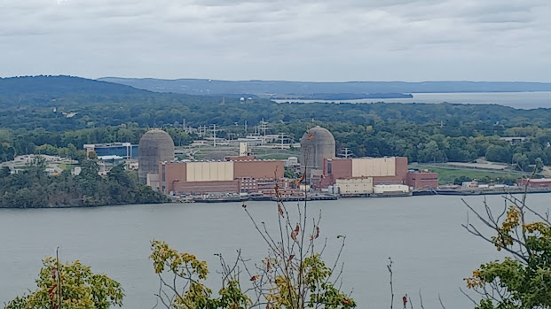
view view across the Hudson of the Indian Point Energy Center near Peekskill
NY, which provided about 25% of New York City's electric needs until its
closure in 2021.
The electricity is now provided by new natural gas plants which will keep the city shy of its climate goals.
The power plant was constructed on the former site
of the Indian Point Amusement Park. Land was purchased in 1954 and the plant
began operations in 1962.
A lot of
factors came into play when it came to the closure of this facility, one of
them being former Governor Andrew Cuomo.
I’m certainly not a fan of Cuomo, for a whole lot of reasons, not the least of
which is the lies regarding the pandemic, where my friends and I witnessed one
of the test centers almost empty, when the media claimed it was “overrun” and
showed imagery of another location.
I hate to even discuss these issues on a
forum like this, because all of them where it was discussed on facebook ended
up getting removed.
It seems that everything Democratic politicians used to stand for is a farce
with modern ones. Environmental issues are one of the biggest ones, which I
could go on about forever, as well as cultural sensitivity. Cuomo stripped the
Tappan-Zee Bridge of its historic name, one that honored both the Native
American and Dutch names for the location, and renamed the bridge for his
father.
On the other hand, “Indian Point” was too offensive, and it was completely removed from all Google maps for that reference.
Nuclear
energy got a really bad rap, and the newer “salt nuclear” processes have no byproduct
because it all gets recycled into the next production process.
We continued down 202 for just a little further, and soon we reached parking
and the southern terminus of the 1777 Trail. I had followed the trail route to
the north, but never did this lower end of it, so it was time to check it out.
The first part of the trail follows what was once known as the Jones Trail, which was a road used for the construction of the Dunderberg Spiral Railway.
1777 Trail for the most part follows the historic Road route taken by British troops under the command of Sir Henry Clinton on October 6th, 1777.
They were traveling from Stony Point to Fort
Montgomery and Fort Clinton to attack American forces there. The historic
name for the road they followed over Dunderberg Mountain was the King’s Road.
I think the original route would have been part of present day Buckberg Road,
and then Bird Hill Road past Tomkins Lake, but the development went in there,
and the original route of the trail had to be moved to the east a bit for
access.
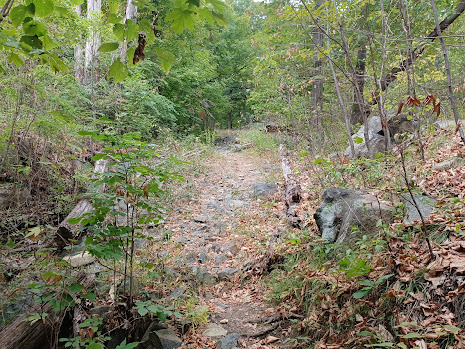
We headed up a foot path, and immediately got on what must have been that Jones
Road, then continued to climb a bit. We passed off of that first road, and then
onto another one just beyond, and stayed with that one a bit longer. The trail
did deviate a bit from the Jones Road, and then came back to it again.
We soon came
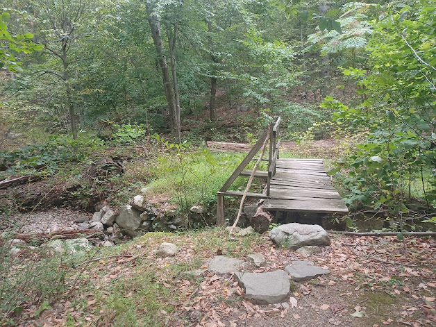
to a footbridge that was established in 1987 by Eagle Scout Enoch Nemanson on
the original Road Bridge abutments, and rebuilt in 2004 by another Eagle scout,
Clint Aylward. Beyond that point, much of the trail turned into a sort
of foot path and passed by some enormous Red Oak trees.
Pretty soon, we picked up the historic King’s Road route. It was on its way up through a rocky cleft in Dunderberg Mountain that was incredibly steep.
I imagined an army making their way up this slope, and it must have been murder back then.
I got way
ahead of the rest of the group and powered to the peak on the 1777 Trail.
To the north of this point, the 1777 route breaks in two, where the British
army split to attack from two angles. This is why there is a 1777 East and 1777
West Trail closer to Bear Mountain.
We weren’t going to continue on this anyway. From here, my plan was to turn right in Timp-Torne Trail.
This trail was one of the oldest in Bear Mountain State Park, laid out in the 1920s.
It was intended to connect “The Timp” down at the southern end of the park with Popolopen Torne just northwest of Bear Mountain. I had done all of the trail pretty much to the north, but never finished the segment from 1777 east over Dunderberg Mountain.
The trail took us over some rocks and then down into a saddle in the ridge, then climbed up with some rough stone steps to more height of land. There were always some views through the trees to the right of us, and the Hudson River soon came into view.
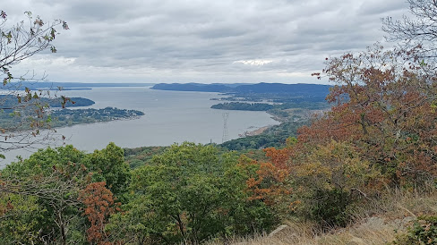
The views kept getting better as we moved on. We could see down the Hudson River to the beginning of the Palisades formation at High Tor, as well as Little Tor and on out toward South Mountain.
Beyond, we could see the Hook Mountain area. On a clear day, the NYC skyline can be seen, and even though it was somewhat clear, we couldn’t really see it well this time.
The town of Haverstraw was visible at
the foot of High Tor.
We dipped down past a glacial erratic, and there was a fantastic panoramic view
of the Hudson River, from the city area and straight ahead to the west, with
the old nuke plant and up river toward Peekskill.
The trail switchbacked a bit and descended slightly, and then came to a woods road followed by a level grade.
I think the woods road was the Jones Trail, and I know the level grade was that of the Dunderberg Spiral Railway.
The project
was the brainchild of Henry J Mumford and associates, and was partly constructed
in 1890-91.
Mumford already had success in similar tourist
railroading in Pennsylvania, having leased the Mauch Chunk Switchback Railroad
from the Central Railroad of New Jersey in 1870 when it was no longer needed
for coal transport (we had hiked this on several occasions).
The pleasure ride would have employed a 900 foot
inclined plane, then a twisting route featuring vistas, tunnels, and a hotel,
conveniently accessible from the West Shore Railroad that was established below
in 1883.
Financial troubles and questionable investors led to abandonment of the project, which grew over in the next few years.
The land became part of Bear Mountain State Park
in 1913, and sections of Timp-Torne Trail and Ramapo-Dunderberg Trail were
relocated onto it over the years, after it was sort of a secret thing found
only by intrepid hikers for many years.
I waited for the others to catch up at this point. To the right was the downhill for the railroad, which went through a very dramatic rock cut. There were never any tracks laid on any of this, but much of it was ready for it.
To the left, the uphill section, it was intended to be a large railroad tunnel beneath one of the rock segments.
I knew of the incomplete tunnel up there, but I had never gone
to it. I walked into the weeds to my left, and came to a rock wall. This was
obviously intended to be a tunnel site, but not the part that was dug in yet.
Once everyone caught up, we headed to the right on the trail, which followed
the railroad bed through the dramatic cut, and then over a bit of a fill. The
trail descended slightly, and then cut to the left, away from the lower section of rail bed, and climbed to an upper one.
To my left, the mouth of the giant tunnel was right before me. This was the side they had begun on and never finished.
It was more than I was expecting heading out there. I had seen some
photos of the finished construction including a sort of manufactured tunnel of
stone, not under a section of the mountain, and I wasn’t expecting to see this
impressive deep rock cut.
It is kind of easy to miss. John said he would have gone right by it.
I went in and walked all the way to the back of where they had finished cutting through. They were pretty close to having busted through with this tunnel when the work halted.
We exited the tunnel and continued along the trail, which from
this point followed that upper level of the incomplete railroad bed.
The section was so nice that they really could have laid rails on this section
we were walking.
The section was perfect; we walked along this level for quite a while, through a cut, and along a somewhat grassy slope along the escarpment of the mountain until I realized all of a sudden that we were no longer seeing the blue blazes of the trail any more.
I had thought that the trails in this area followed much more of the railroad bed than they actually did, but it turned out it was only sections.
We had to turn around and go back, and there was a steep spot down from the rail bed to the east, which led back down to the previous grade, the one below the tunnel site we had been on before. It then followed that section of the rail bed a while longer, which was well graded like a shelf most of the way, and occasional cuts and fills.
The trail eventually turned off of this lower section of grade into a very light young forest to the right, of dense birch and other sort of scrubby stuff.
After a bit of a trail, the trail turned left and passed through
an area with some views out toward the Hudson through the trees, and descended
to the north a bit more.
After a bit of steep stuff, the trail joined with the red dot on
white blazed Ramapo-Dunderberg Trail.
This trail is the oldest in the entire Harriman-Bear Mountain Region, first
cleared and blazed in 1920 after approval of Major Welch who ran the park.
The over twenty mile long trail was like many of those early trails that would connect between train stations for travelers from New York City.
It traveled
from near the NY/NJ state line to below Dunderberg Mountain, and like the 1777
Trail, some of the eastern end of it had been rerouted.
As I understand, the Dunderberg Spiral Railway was not part of either of the
two old, major trails that passed through this area until late in the twentieth
century, but they make excellent additions.
I had hiked almost all of the Ramapo-Dunderberg Trail as well, from the western end all the way through to the Timp Pass, which I finally got to I guess in 2020.
There might be a short bit in there I haven’t hit yet, but I’m not sure
at the moment.
We re-grouped at this intersection, and to the east, both Rampao-Dunderberg and Timp-Torne Trails continue together down to where we were parked, but we were going the other way. We’d take Ramapo-Dunderberg trail to the west.
We turned left on that and started climbing very steeply to the west.
I did not know it at all prior to this, but the trail followed the partially
constructed funicular grade for the railroad! I realized it after the first bit
of cut and steep stuff we went over. It was graded just like some of the old
coal country inclined planes I’d walked before.
I should have known looking at the map, how straight the trail was shown, that
it would have been something like that.
This was the steepest climb of the entire hike. There was a ballast type of rock on the inclined plane, but trail stewardship led to the creation of a more even treadway on some sections of this slope.
I powered on as quickly as I could up this grade to get it over with, and when
I reached the point where the westbound Ramapo-Dunderberg Trail turned off to
the right, there was a large stone abutment. This was apparently where the
plane would have crossed over one of the other sections of track. I waited at
this point for everyone to join me.
The trail continued along the rail grade heading to the east for a good while. We passed over a fill where there looked to be natural rock overhangs to the left, and then came to an unfinished part of the railroad.
The trail went up to the right, and they apparently hadn’t finished blasting through a large crag just ahead.
The trail went up to a spot where there was another splendid view, this time
down around the bend of Indian Point and toward a broad view of the Palisades
formation of igneous extrusive basalt.
We weaved around this rock outcrop and had another great view of the Indian Point nuclear plant, and then reached another well graded section of the spiral railway. We continued on that for a bit, and at some point we turned left away from it to climb further up the mountain.
After a little while, to the right, there was a white blazed
trail that I didn’t recognize from any of the trail maps I’d seen of the area
before. It was not included on the Bear Mountain State Park map, and so I
figured it was going to be a dead end path to a view point.
I was right; we hurried up to the top, and at a glacial erratic, there was a
good view around the bend in the Hudson River.
From this vantage point, we could see the Annsville Creek, where it joined the Hudson River, and the long causeway that the river line of Metro North, formerly New York Central, follows across.
We had hiked along some of that on the Annsville Greenway on a hike years ago.
Beyond there, we had a great view of the town of Peekskill, which we’d also walked
through a couple of years on our way to doing the Camp Smith Trail, and on
another to the Briarcliff-Peekskill Trailway.
We headed back down the side trail the way we’d came, and then continued on the Ramapo-Dunderberg Trail ahead. It climbed for a little bit more, and then off to the right there was a bit of a view I noticed through the trees to the right. There was a little side path leading out to it.
What I found was a commanding view toward Bear Mountain and the Bear Mountain Bridge, as well as Anthony’s Nose, the promontory on the east side of the Hudson from Bear Mountain.
This is probably the best view of the
entire Bear Mountain Bridge I’ve ever seen. The Anthony’s Nose overlook is
really amazing because it’s just about above it, but this shows the entire
length of it, east to west.
The Bear Mountain Bridge was originally supposed to be a railroad bridge, where work started in the 1880s. Work had “progressed rapidly” on the footings to this bridge, but it stalled out and was never completed for that original intended use. Instead, the highway bridge was planned, and eventually completed in 1924.
At the time of its completion, it was the longest suspension bridge in the world, a distinction it held for only 19 months, when that title was taken by the Ben Franklin Bridge between Philadelphia PA and Camden NJ.
In the foreground, we could see Iona Island, the former Navy munitions base on the Hudson River.
\This location too has an interesting history, from its
earliest days as a native American fishing settlement, to an encampment for
British troops during the Revolution, an orchard farm, and an amusement park.
The government bought the island in 1899 for use as the munitions depot.
Today only five original buildings from that use remain. Iona was a very strategic location, protected by the Hudson, but only 41 miles from New York City by rail on the West Shore Railroad.
Iona Island saw America through World Wars I and II, and closed in 1947. For a time after that, a “mothball fleet” of ships was stored adjacent to it in Tomkins Cove.
The island was purchased by Palisades Interstate Park Commission
and became part of Bear Mountain State Park in 1965. Today the remaining former
military buildings are used as storage for park maintenance. The area is
popular among birders and rail fans today.
We admired this great view for a while, and I went over some of the maps to decide what we were going to do for the remainder of the loop.
I had a few plans for where we would go, and I would base it somewhat on the mileage from along the way.
John was giving me the distances pretty regularly, and I considered that the farthest west we would go would be back to the 1777 Trail and follow that north. If we ended up covering considerable distance more, we would just cut down to the north a little earlier. It was looking like that would be what we would do. We were headed for Doodletown, and that would take some time, and would be some more distance.
We continued to the west for a bit more, and passed by a small glacial erratic before descending somewhat from Dunderberg Mountain.
As we made
our way slightly downhill, we passed over the right of way of the Dunderberg
Spiral Railway one last time. It was well graded and very recognizable in both
directions.
I had expected that the trail would have followed this right of way for more time than it did, and that the trail would hit most of the major points of interest on what was constructed for this, but that didn’t happen. I know there is one somewhat major stone tunnel along the way that we never got to see.
The Spiral Railway was intended to be ten miles long, so tracing that would be the better portion of an entire hike.
This means I need to go back to this
point and do the entire railroad as the main theme, and figure out how we’ll go
about that. It looks like it’ll be a pretty great trip to take. There’s just
too much stuff to do and not enough time to do it all.
We continued over one more slight peak of Dunderberg Mountain, descended through a saddle, and then reached one more height of land with a view to west, toward Bald Mountain and West Mountain.
The trail descended from this point rather steeply into yet another saddle between land, and then climbed some more toward the peak of Bald Mountain.
I had already climbed Bald Mountain before, and I’d found the
two old Cornell Mine openings along the way, so I really didn’t need to see all
of that again. There is a good view from the very top of it, and the Bear
Mountain Bridge is visible from there too, but I didn’t want to push it too
far. There was a lot more I wanted to do a little lower.
By this point, based on the mileage that John was recording, we were already over seven miles. We needed to start getting the loop closed in.
On the way up Bald Mountain, we stopped partway up and turned to the right on the Cornell Mine Trail.
This trail leads from the Bear Mountain
lot to this point on the Ramapo-Dunderberg and is another that’s been in place
for quite a long time.
The same Thomas Cornell who was a steamboat magnate and railroad man early on,
for whom Cornell Mountain in the Catskills is named, I understand owned the old
iron mine on Bald Mountain for which the trail is named.
The trail descended very steeply on switchbacks. On the way down, I checked out a side path that looked like it was the one that went to the deepest Cornell Mine hole.
I had been to it before, and I’d been into it (it’s full of water), but I couldn’t quite find it this time.
I did find what
looked to be other mined areas or prospect holes, but not the main mine. I wasn’t
too worried about it since I’d seen it before. The other mine hole is a deep
pit near the top of Bald Mountain just off the trail, and I’d found that as
well previously.
My plan going ahead was that we would follow the Cornell Mine Trail to a sort of level area on the bottom of the mountain, and then bushwhack to the west a bit to make our way to another old mine.
It was shown off trail
just a bit from the Cornell Mine Trail, and I thought maybe we would find it.
Just to the north of where the mine was located off trail, was
an old woods road that went to the west from the Cornell Mine Trail. I thought
maybe we could find it off of that as well.
This wasn’t just a random woods road; originally this was the Caldwell Turnpike, and it went both right and left from the current route of the Cornell Mine Trail.
The road originally went from about the end of Jones Point on the Hudson River to the community of Queensburo, which is now located on West Point Military Academy property just to the north of Bear Mountain and Popolopen Torn.
The old road to the east of where we were is pretty much unrecognizable and is now basically a stream or so it says on one of the signs out there, but it used to be possible to follow it a little way east of the Cornell Mine Trail to the former site of the first church and Schoolhouse of Doodletown starting in 1851.
Doodletown was an isolated hamlet within the municipality of Stony Point.
The area was first purchased from the Haverstraw native Americans by Stephanus
Van Cortland in 1683.
The area was lightly settled, and in 1762, Ithiel June purchased 72 acres acres from the Tomkins family who were living at the site. The June family were French Huguenots who’s last name was anglicized to June. It is said that the name of the settlement comes from the Dutch word “Dooddell” meaning “dead valley”, and that other settlers suffixed the word “town” to the end of it.
The
settlement was also known as Montville or Mountville at times and in certain
applications I’ve found.
The early settlers were loggers and miners, and then later residents worked at the amusement facilities that existed on Iona Island, and a hotel was established there shortly after the Civil War. It became a US Navy installation when the military purchased in about 1900, and residents would work there as well.
The height of the population of Doodletown came in the 1920s, by which time the
settlement had a school, a church, cemeteries, several small businesses, and at
least seventy homes. With the formation of the Palisades Interstate Park
Commission around that time, several residents went to work for that establishment
as well. Some residents like from New York City had seasonal homes in
Doodletown.
As the growing Bear Mountain State Park bought up land in Doodletown, most of
the residents were gone by the 1950s. By 1965, the few families that held out
and refused to move had their homes taken through eminent domain.
The homes were disassembled or demolished, the roads closed, and the area reverted back to nature.
The only building that was allowed to stay was the sizable school
house which served as a shelter for hikers until vandalism got to the point
that it was too much to deal with, and it too was demolished in 1980.
The area was left rather forgotten for years, and at some point
a self guided tour was made up with signs telling of what used to stand at each
location.
Our route from this point was to follow that old Caldwell Turnpike to the west,
further into the Doodletown settlement.
Pretty soon after we got onto the road, there was either a building foundation or more likely a mine or prospect pit to the left side.
This might also have been one of the Edison mines. Thomas Edison
had purchased mines on the outskirts of Doodletown to experiment with his new
mining techniques in about 1890, but he never ended up going through with it.
We continued on past this and out to what is shown on the maps as the “Ski Trail”. It’s not a marked trail, and is just an old road that goes up and around the southern end of Doodletown. We continued past this straight on along the old Caldwell Turnpike, and then to where there was a large concrete dam on the right.
The old road used to continue through where the water is now. If I understand the history right, the dam was built in the 1970s after the town was vacated, on the Timp Brook.
I’m not sure why they built it,
but I also understand there’s some sort of a water treatment plant remnant
there as well.
We didn’t look for any of that other infrastructure this time, but we did walk out onto the concrete dam. There was a metal set of bars to keep people from walking out onto the dam to the end, but they were really easy to swing around. Justin went out there first and laid down on the end of the da where the water falls. I followed him, and all of the others soon followed.
As I looked off of the front of the dam, there was a lot of discolored water, like sulfur seepage.
I figure this could be left over from some of the area
mines, or otherwise it could be leaking septics or whatever associated with the
long gone town.
It was quite beautiful looking over the pond, and I noticed on the other side
of it was a cemetery. I was not expecting that it would be that close to the
side of the pond, but that was one of the destinations I wanted to hit.
I was kind of expecting to see an abandoned cemetery, but this one looked to be
well kept.
Rather than walk all the way around, I figured we could just
head through the woods because it was so close, and then hop across the little
tributary that feeds into the pond from the south.
This was pretty easy to do because there was almost no undergrowth, and it
looked like some people did this anyway.
We climbed up the slope after the little brook, and soon we were in the edge of the June Cemetery.
There were some very old graves, and some
separated family plots there.
This was actually the second June Cemetery; Caleb June willed the property to
his heirs in 1871 for a burying ground, and it is apparently still in use
today. By the time we got up there, there were some signs saying to stay out,
so we didn’t bother to spend that much time up there. It was quite a pretty
spot with a bench overlooking the pond through.
The first June Cemetery was a little further north along another road, and I planned to look for that one after a little bit.
We continued from the cemetery along the access road back out to Doodletown
Road. Once there, we turned left and meandered a little bit to reach the old
intersection of Doodletown Road and Pleasant Valley Road. Both roads were once
paved, but it’s all broken up and growing in pretty much now.
This intersection was the only one that had a road sign in the entire town. On the middle of the corner of this intersection was the Seigle House. There was a sign to the left in the intersection that read that the Herbert Cemetery was to the left, and I stared impersonating Herbert the Pervert from Family Guy and making comments about popsicles.
On the right side of the road, directly across from the intersection with Pleasant Valley Road, the old Doodletown Church, which came after the aforementioned one on the Caldwell Turnpike.
It was a white building of simple construction with a little steeple. I set up some then and now history photographs of the site as best as I could including of the church and of the intersection.
The others went ahead up Pleasant Valley Road, which was a
gradual uphill, while I was setting up the history photo compilations. I then
hurried to join them.
Up ahead, we came to a wall on the right side with a set of stairs going up through it. This was the former site of what was known as the Dunkel Home. It was owned by an O. Herbert who had a general store on the first floor, and also a blacksmith shop, I guess on the same property. The steps were so badly grown over one would could hardly even tell they were there.
There was a road just ahead on the left side of Pleasant Valley Road once known as Herbert Hill Road. We turned down this dead end road, which led to the Herbert/Weyant Cemetery.
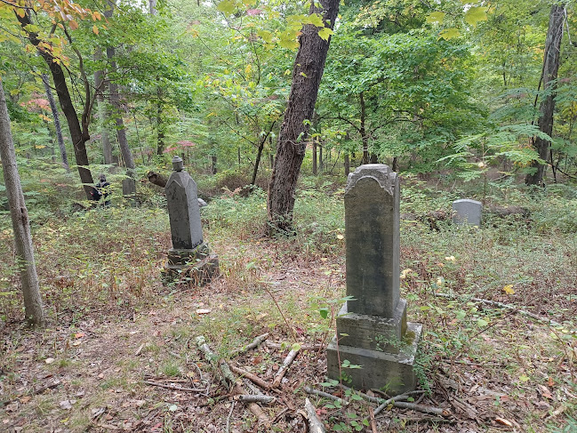
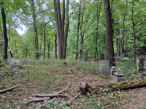
Soon, we reached the cemetery, and at first I thought it was just a small plot
because there was a nicely kept section of graves on the left. I figured it was
just like the Second June Cemetery where it was still used and people could be
interred there, but only one small section was like that. Beyond this cleared
plot, there was a huge cemetery sprawling all through the woods with tons of
overgrown graves. Some of them were broken and totally illegible, but some of
them were really in nice shape and easy to read, just grown over badly.
There is supposedly supposed to be some sort of state thing in New York that
keeps cemeteries cared for, but this has been abandoned for quite some time for
sure. I turned to the right, where there were two branches of the road coming
into the cemetery, and skirted that side.
There were a couple of little family plots to the right, mostly overgrown, and then I cut through the woods to the left between graves.
The others kind of went around more in a clockwise fashion
through the cemetery.
I read several graves as we went through, and then we came out behind the still
maintained plot before heading back out to Pleasant Valley Road.
We turned left on Pleasant Valley, and pretty soon there were two almost invisible stone columns in the brush to the right. This was the entrance to the Tamsen Houses. There was reportedly an “L” shaped house there that belonged to the Herbert family, as well as a rental cottage.
We continued uphill on Pleasant Valley Road, and across from a lane that led to three other homes at one time, there was the giant Oak tree of over two hundred years old.
I’d seen it before, but sadly this time it was
dead. The tree had seen the town through every stage of its development and the
“Mad Anthony Wayne” march in 1777, but will probably fall over within a few
years now unless there’s some little bit of it that is still holding on to
life.
We made a left turn from Pleasant Valley Road onto the “Ski Trail” when we got to it. There is plenty more stuff that we had not yet seen around Doodletown, but we didn’t have time to visit all of the ruin sites.
The ski trail followed the old road uphill a bit, and then passed through deeper woods.
We were at the top of a slope for a bit, and then descended
somewhat gradually and crossed a small tributary to the Timp Brook on a bridge.
It was somewhere in this area I found out later that one of the Edison Mines
was just off of this trail a short distance. This, from what I understand, is a
pretty cool horizontal one we could get into. Knowing this, I now I have to go
back to the area to check it out.
We continued on the Ski Trail to the north some more, and we crossed over the same spot we were before at the old Caldwell Turnpike.
I had
thought that maybe the old church was closer to the pond we were at than it
actually was, but I found out how much farther away it was.
We continued straight from this point, and then crossed over the
Timp Brook, or maybe it was Doodletown Brook at this point, just a bit
downstream from the pond we had stopped at earlier. There appeared to be a
small waterfall below the bridge at this point, and I was interested in going
down to see it, but I was getting a bit tired so I didn’t bother to climb down
this time.
We continued just beyond this point, and soon reached the intersection with another old road to the right. I forget if that was Doodletown Road or something hill road. We continued only a short distance, and 1777 East Trail turned off from this road to the left.
This was a more wooded section, and so I decided that would be the way we would go.
By going this way, I thought we might be able to get to the
third and final Doodletown Cemetery that we hadn’t seen yet, the First June
Cemetery, the oldest one. It was just up a slope from this trail by a little
bit. There was also supposed to be a connector trail down to the right from
this one to the Cornell Mine Trail, which we could then take to the south and
get toward Iona Island.
We continued up the trail, and at the point where the side trail was supposed to head downhill, I think it was too terribly overgrown to recognize.
It was at a point where there used to be another building standing to the right, and we didn’t want to try to bushwhack down through to that.
When it came to the First June Cemetery, I watched the slope to the left of us,
which was far steeper than I was anticipating we would find, and it would be
hard to go up the slope to try to find it. It might just be a tiny thing that
we wouldn’t recognize, like maybe a family plot.
I think I knew the general area it was supposed to be, and so I started bushwhacking up when I reached that spot.
I’m very confident I found the correct area, because there was an old road, which was not recognizable form the 1777E Trail.
The old road was
badly overgrown, and it disappeared into an overgrown field sort of area next
to a stone row. I tried to walk through some of it to see if I could find some
headstones, but it looked to be too far out of the way. I would have to come back
to try to find the cemetery another time off of that other road.
We headed back down to the 1777 E Trail, and continued following it to the north. I saw one drain area to the right thinking that maybe it might be a herd trail that might get us down to the lower trail from there, but it was really crappy.
We really didn’t have a choice but to continue following this trail to the north for a bit longer.
The route went along some steep rock walls on the left, which I
think might have been quarried somewhat at some time.
We continued on the trail to the north for a bit, and eventually the Cornell Mine Trail appeared on our right. We turned hard right here to continue following that trail back to the south for a bit. This segment of it quite closely parallels the South Entrance Road to Bear Mountain State Park, which also parallels Route 9W.
This section of trail was really nice at first because it had very recently been cut back.
Someone had gone pretty crazy with clippers to
keep this section, which goes through some pretty dense understory, wide open.
This was all going great until the holes in the bottoms of my old Reeboks
started taking on thorns from the stuff that got clipped. After I got a couple
of really big thorns in my foot, I had to stop and take the shoes off to pull
them out.
My socks already had holes through them where those holes were in the shoes, so
it was like I was walking totally barefoot on those parts of my foot.
The Cornell Mine Trail came out to hit the paved road out of Doodletown which goes down the slope to Rt 9W, and when we came to that spot I stopped and took my shoes off to try to get the stuff out.
I did have to pull
one pretty big thorn out of my foot, and then it was doing much better.
I usually throw something into my shoe to help protect the foot, including
putting an entire tastykake apple pie tin and box into the shoe to cover the
hole, but I was out of those this time.
However, this time Diane came to me with some long pieces of
Sycamore bark that did the trick pretty well. I put a long swath of Sycamore
bark in each shoe, enough to stay in place under my foot and to cover the hole
in the shoe and it worked great.
We continued down the old paved road to Rt 9W and crossed the road immediately. We started heading south along the highway, and we soon crossed the Doodletown Brook where it flows into the tidal Hudson adjacent to Iona Island. It was quite a pretty spot.
From that point, it also wasn’t much farther to the entrance road to Iona Island.
I was considering walking out onto Iona Island this time,
because I had never run a hike actually out onto the island, although I had
gone out onto it with Jillane several years ago and it was pretty cool to
explore a bit.
This time, accessing the island for the group was not going to happen unless they were all good with getting their feet wet. The tidal Hudson apparently finds this section of the road going under water on a regular basis, and beyond the spot where the sign said “road may flood”, it was completely under.
I walked out and almost all the way across it. A guy I saw there on a bike said he wouldn’t try because it was definitely up to the knees.
My
assessment right from the start was that it would hardly be over my shins.
I was right, it barely got higher than my ankle and was actually a nice little
walk out there. I got some nice photos of the flooded road, as well as of
Dunderberg Mountain, and toward Anthony’s Nose to the north.
As I walked back through the water, I noticed how the pavement had tons of bubbles coming up from out of it below. There must have been a lot of air trapped in the soil below the pavement.
We headed back out from there, and then continued to walk down 9W to the south a bit more until we got to the trail head to the Jones Point Path, the final leg of our journey for the day.
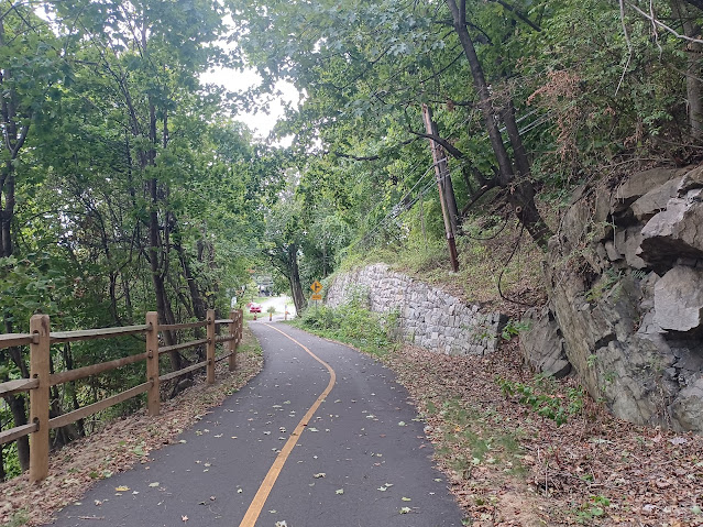
This path was a pretty neat route. It originally must have been
part of that Caldwell Turnpike out and around Jones Point, or at least was part
of it. It was developed as a through highway in 1906.
It served as the main road around Jones Point until the current
alignment of 9W was built in 1930. The original road was open for a bit, but
then closed and informally used as a trail for many years. The southern end of
it is still actively used as a dead end road to reach the residents at Jones
Point.
There was a very nice kiosk with history on it at the trail head, which talked of the Harriman estate, and how Sing Sing Prison was supposed to be where the Bear Mountain Inn is now, but the Harriman Family blocked it.
A sign on the start of the path designated this the Hudson River
Greenway Trail. I wonder how much of that designation is in place. I definitely
want to continue hiking along the Hudson much more, connecting from where I’ve
already been. There are a lot of great little parks on the way I’ve never done.
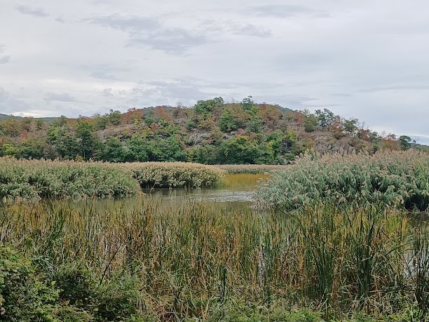
After just a little ways down the trail, there were good views opening up of the marsh land around Iona Island. There were then good views of the island, of the old buildings on it, and of Anthony’s Nose beyond.
Aside from those views, there wasn’t a whole lot to see. I started looking along the right side of the path for four leaf clovers, and of course I found several.
Two of what I found in the stretch were five leaf
clovers. I gave those two to John and Diane, and Justin got one of the four
leaf ones.
The railings for this section of trail were a lot of split rail
fence, but the old highway barriers in some cases were still in place beyond
that. They were concrete posts with vertical metal hooks through which cable
was strung. I’d never seen anything quite like this used in such a place.
We skirted some rock outcroppings to the right for a bit, but then descended
slightly and came to the end of the trail, where it becomes the little settlement
of Jones Point.
This little community had the main road keeping to the right, which we could see sort of looked like a main highway, and a smaller road over to the left that went closer to the former West Shore Railroad and the Hudson waterfront.
We chose to follow that route because it would be prettier.
We continued along this road until it came back together with
the main road. There were some junk cars laying around in a small lot, and then
we came to a sign that read “This is not Bear Mountain, please respect our
privacy”.
I’m sure the few residents that remain in Jones Point probably didn’t like the
trail going through.
Just ahead, there was a beautiful old stone church signed as the Turning Point Church.
I had found one old photo of a church that had existed at Jones Point prior to this one, of wooden construction, noted as a “protestant church”, but I couldn’t find anything else on it. I assume that the current one replaced the old one, but I just can’t be sure.
We continued on the old road just a short distance more, and we came out to the trail head where we had started. We finished in pretty good time, with plenty of daylight remaining.
We had done over fifteen miles as planned, and covered a whole lot of new ground that I’d been wanting to do for years, and made note of many more things we needed to come back to do.
There is so much interesting stuff to the south to do heading to
stony Point, and it’s probably only one hike’s worth of stuff to get to where I’d
walked the shore line in Haverstraw. To the north, I would have to arrange a
tour or something, but I would love to go through West Point Military Academy.
The list goes on and one, and I’m not running out of stuff to do.

















No comments:
Post a Comment