

Hike #1504; 9/18/22 Hartshorne Woods/Buttermilk Valley to Belford with Stephen Argentina, Robin Deitz, Brittany Weider, Gregory Andres, Serious Sean Dougherty, Justin Gurbisz, and Brianne ?
For this next one, I wanted to try to have another hike that would bring us to the Raritan Bay area, and finish with a bit of hiking on the beach as sort of an end of Summer celebration.

It would be literally the last
hike of the Summer season.
It seemed like a good idea; we would do some trails I’d done
before, as well as a bunch I had not. A lot of them I’d not done in a very long
time.
The area of Hartshorne Woods has always been possibly my
favorite Monmouth County park for everything it has to offer. I’d had some
really great ones there going back as far as 2007.
For the end point, because there’s really not a lot of good options, I chose Hill Street Park in Keanesburg for parking.

All of the stuff near the waterfront costs money, or if it doesn’t, they’re sparse and on streets in front of homes.

From this point, we shuttled with as few cars as possible to the
starting point, Buttermilk Valley trail head for Hartshorne Woods on Navesink
Avenue.
I didn’t know it at the time, but appears that this parking lot is built on an abandoned railroad grade. The former Central Railroad of New Jersey had a spur from that went up to this point. We had walked the spur from it that went down to Claypit Creek area, but the military apparently built a spur from there for their facility when the property was the Navesink Military Reservation.

We started by heading directly into the woods, and my plan was to follow the Laurel Ridge Trail.

At first, I didn’t see which trail it was
supposed to be. Monmouth County Parks don’t mark their trails to the standard
that most parks mark them, and so it can take some getting used to following
the weird shapes and such they insist on using instead of typical start, end
and turn blazes.
We soon got on Laurel Ridge and we were headed out into the
park. There were a ton of mountain bikers using this section, so we had to
watch to stay out of their way.
We moved on ahead for a bit, and the first trail intersection up in the park
was the trail known as Grand Tour.

I chose to head left on that, to do the farthest north bit of the park. I might have walked this bit before, but I didn’t remember it, so we did it anyway.

It took us a bit uphill, and the cycling groups had done a really good job
building curves and such so that they didn’t crash going through. It was really
very impressive.
The trail crossed an access road to a water tower, and then made
its way as a foot path back down hill to the Cuesta Ridge Trail. We took a
break and let everyone catch up there, and then we continued straight across on
Grand Tour.
Hartshorne Woods has always been a favorite park for me for biodiversity. I find that the park has more of a wide variety of trees than any other park I’ve ever noticed.

It also has lots of incredibly huge trees, which I also love. We passed several of them, frequently.

We weaved around through pleasant woods, and then came to a fork
in the trail. This was the section of the park known as the Monmouth Hills. The
trail to the right cut the giant Grant Tour loop in half. I had done the lower
end of this before, but not the upper, so we turned left to continue.
This section of trail followed an interesting slope, with the downhill
below us to the right. The entire area after a bit looked to be cleared below
us, with a trail running through it that I don’t think was represented on the
maps.
This seemed to be some sort of a new herbaceous opening like
they do in PA State Game Lands, but I wasn’t sure.
Pretty soon, the trail descended to it, and then passed through the open area. It turned out that this was an invasive species restoration project.

There was a lot of bad crap in the understory that was being removed,
and there were signs with some of the before photos. Stuff like Mile a Minute
Vine and other crap was all growing up the trees and choking them out. We could
see that some of them still had it on them. There were also lots of
Ailanthus/Tree of Heaven in the open areas that needed to be dealt with. They’re
actually doing a really great thing for this area, considering how bio-diverse
it is.
We meandered through a couple of these big clearings, and I looked at my phone GPS to find that we were in the wrong place.

I was aggravated
that these trails were so poorly marked and hard to follow where we were.
Sean knew exactly where we were, because he’s explored it a lot,
but I thought we took all of the turns correctly and were heading toward Upper
Rocky Point.
We stood at a trail intersection so that I could get my
bearings, and an attractive young girl came walking down the trail to the left.
She asked me about where she was, and I was only just figuring that out myself.
It turned out that she was also trying to get to Rocky Point, and she had
walked also from Buttermilk Valley.
We chatted for a bit, and Sean knew enough where to go, along with a shortcut,
so that we could get to that point. It made more sense to just turn it over to
Sean and follow him since he had a better grasp of these oddball trails than
me, and I invited the girl to join us since we were going the same place.

She introduced herself as Brianne, who lived nearby, right off the Henry Hudson
Trail, which was part of our planned route. She couldn’t do the entire thing
with us because she had kids to pick up that night, but she agreed to join us
for a little while anyway.
Sean led us out of the woods and onto a road in the park, and I
actually didn’t pay much attention to where we ended up at this point.
Somehow, we ended up on the Grand Tour road to the south side of the woods, and
we followed the road for a little bit. We almost walked by where the turn would
be that we’d have to use to get back into the woods.
I didn’t want to stay out on these roads too much longer. Governor Phil Murphy
lives out at the end of it, and I’m definitely not a fan after what he’s done
to parks in so many ways.

We headed back into the park on a former roadway for a while, and then eventually came to the spot where Rocky Point Trail broke off to the right, as well as the Command Loop.

I had done Rocky Point Trail before, but it’s one of the best trails in the
park, so that was the way we wanted to do it.
The trail is apparently used by mountain bikers, but it’s a
harder route, so there would be fewer of them we’d be in the way of.
The mountain bikers passed by us a lot while we were out, and we tried to be
courteous and let them pass us when we knew any were coming. These people were
very courteous as well, and slowed down for us.

We headed to the south, and at a bit of a sandy promontory, got a good view out to the Navesink River.

It was quite a nice little spot. The
trail went steeply to the left and continued to descend, then followed a side
hill path to the clearing above Black Fish Cove.
I had first visited this site in the Summer of 2007, and the
group and I spent a lot of time on the pier there, doing jump flips off of it
into the Navesink River.
The Navesink and the Shrewsbury River come together in this tidal area, and
dolphins come in to swim in the not so brackish waters. It’s really a great
spot.
Brianne and I went out onto the dock, and she told me about how
her dad used to take her out there to that exact spot, and she was very happy
to be there.
I went into the river for a swim, but didn’t jump off of the dock this time
because I could tell the tide was getting kind of strong at this point.

There was a nice picnic bench out in the shade near this lovely spot, so we stopped there and took a break.

While we sat at the bench, Brianne said that I looked exactly
like her mother’s ex-boyfriend, and asked if she could take a picture of me to
send to her. I wasn’t sure exactly how to take that, but she said it wasn’t a
bad thing and that her mom is young.
Brittany had been running late, and planned to meet up with us in this area. She finally showed up after running down from the lot to the pier, and she immediately went in for a swim as well.

From the pier area, we continued on the Rocky Point Trail to the east for a bit more, and there were some nice little views out toward the Shrewsbury River, and the barrier island was in plain view at Navesink Beach.

When the foot path reached the road that leads down to Lower
Rocky Point, we turned left on it to head uphill a bit. This brought us to
Battery 219.
At first I thought this was the larger Battery Lewis; I’d been to both of them before and they look similar, but Lewis is much larger than 219, and 219 is completely closed off to public. We walked around the outside of it and I was kind of sad that I couldn’t even walk under it. We went up on top of it to get a better view of the Shrewsbury River and Navesink Beach.

From there, we headed uphill a bit along the access road to Battery Lewis.
Battery Lewis
is a massive concrete, steel, and earth-camoflauged fortification consisting of
2 casemates, each enclosing 16 inch Navy guns, connected by a central traverse
magazine.
It was built upon the prototype developed by the
US Army in the 1930s for a new generation of batteries.
Battery Lewis is one of 19 remaining casemated 16
inch gun batteries built between 1942 and 45 in America. It is the only one left
in New Jersey.
The gun displayed in the battery is similar to,
but not original to those used in this battery. This gun came from the
Battleship New Jersey and is same size.

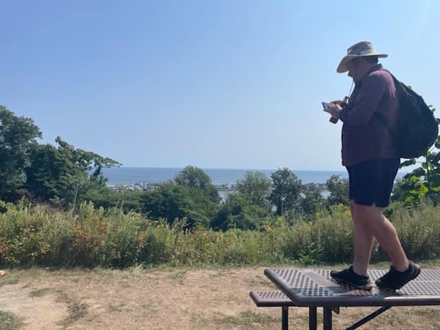
We headed over to the giant gun, and used that to get our group shot.

The giant Battleship New Jersey gun was a great little spot, but
we couldn’t just stand around it. Justin wanted to get up on it.
Even Justin couldn’t pull himself up the behemoth, so the group helped to hoist
him onto it. He then shimmied his way up the length of the gun to get right to
the end of it, which made for the perfect shot.
The gun was not in place the first time I was there, but it was the last time. This time, there were a whole lot more interpretive signs placed all over the vicinity as well, telling seemingly every story there is to tell about the military site.


The original owner after the native Americans, and the park’s
namesake, Richard Hartshorne, was an English Quaker who came to America in 1669
and acquired 2,400 acres of land that included this area. Hartshorne became a
prominent resident and became heavily involved in political colonial affairs.
Richard Hartshorne’s land holdings were divided among his heirs, and most of
what is now the park remained in the family until well into the 1900s. 224
acres of that land ended up becoming part of the military reservation.
The military activities focused on harbor defenses from 1942 to 1948, and then
Air Defence from 1950 to 1974.
After the site was deactivated, many of the structures were explored for years and featured in places like Weird NJ. Most of that time had ended by the time I first visited there.

I could barely cram through the gates at either end of Battery Lewis, and it was basically just a hallway and rooms at the time.

Just as we were finishing with the photos at the gun, a guy came
out from around the corner with a group of people doing a tour. He had a
national park insignia on his shirt despite Hartshorne being a county park, so
I figure it might have been a national program. Of course, Gateway National
Recreation Area for which Sandy Hook is a part is just a couple of minutes down
the road.
Part of me wanted to try to join in and sound like we were interested in what he had to say, but I always read everything anyway.

I was interested, but I also didn’t feel like our group was the kind to be listening in at that moment. We were in full frolicking mode.

It was fortunate that this guy came out with his group just after Justin had gotten down off of the gun, although there were no signs anywhere saying that riding on the gun was not allowed.
We went to walk by the group and not disturb their tour when we
noticed the hallway through the Battery was open!
Of all of the times I had been there, this corridor had never been open before. We walked into it, and saw some displays they had up passing through. They even had new modern lights illuminating the way.

It wasn’t just the corridor that was open. Several of the rooms
off of it were also wide open.
One of the rooms had several large munitions shells sat on display in it.

Another room had displays on all of the walls that had historic
photos of Battery Lewis when it was in operation, as well as a full diagram of
the building layout.
Another surprise thing that was open was the restroom area. This
had the normal urinals, but also had toilets right next to one another without
walls between them.
At the far end of the corridor, there was a table with literature, and the bars that had always been across it, only they were open.

We exited the building, and unfortunately Brianne had to leave to head back to her car.

She wasn’t exactly sure the way to get back, but Sean
and I agreed the smartest thing to do to get back there quickly would be to
take the Cuesta Ridge Trail. Sean directed her over to the trail head and we
took a little break at the restroom buildings.
Once everyone was done at the restroom, we headed out of the park to the north, and where Portland Road went right, we continued on the Grand Tour road to the left. This brought us uphill to where the Henry Hudson Regional High School was on the right.

We passed the high school, and then began cutting through their ball fields to the north. Straight ahead across these fields, the Twin Lights of the Navesink came into view.

The first time I had visited these lights, we came through this way, and I
figured we’d still be able to do it.
The
non-identical lighthouses were constructed in 1862, on the strategic point
south of Sandy Hook, Raritan Bay, New York Harbor, and mouth of the Navesink
and Shrewsbury Rivers. The site had been home to a lighthouse since 1828.
One light would flash while one would be fixed,
providing a rough determination of location.


The north tower light was taken out of service in 1898, and the south tower was electrified. It was one of America's first electric lighthouses.

The light was automated in 1949, but then
discontinued entirely in 1952.
In 1962, the Twin lights were acquired by the
state of New Jersey as an historic site. A light was reestablished in the North
Tower as a private Aid to navigation by the Shrewsbury Power Squadron.
The lights stand 246 ft above sea level, and offer
a commanding view of New York City, Sandy Hook, and down the coast of NJ.

We headed onto the lawn area after cutting through the line of trees, and soon there was a good view to the right, of the Highland-Sea Bright Bridge, also known as the Sandy Hook Bridge.


This bridge was constructed in 2011 to replace the old lift bridge that had been in place since 1932.

There was an even older beam bridge across at the site prior to
that.
I remembered watching the bridge open and close when I walked to the site many
years ago, and even photographed it from afar, thinking I might be glad I had
these photos of it in action. I’m very glad that I do now. I also walked across
that bridge several times on hikes.
When we hiked through in the Winter of 2010, we even witnessed the destruction
of the old bridge during construction of the new one.

I set up a then and now photo from the lawn outside of the Twin Lights using one of my own older photos from the same location.

From there, we walked around the front of the giant lights and
main connecting building in a counterclockwise fashion, and then entered on the
west side.
One of the reasons for doing this was because Governor Murphy had announced
that all state parks and historic sites would be free for the 2022 season.
When we got into the building and wanted to go up to get the view from the
light, we were told they had reinstated the fees because that was just for the
Summer season. Nevermind the fact that it was still technically Summer for a
couple of days. Apparently they stopped the free admission after Labor Day
weekend.
Not a Cialis commercial
I was pretty annoyed by this, and as much as I love the view from the Twin Lights, and it is kind of worthwhile to see the view, I decided I wasn’t going to go up.

We’d just check out the museum on the bottom floor and
get out of there.
There was a secondary building outside that had one of the older
lights from the house on display inside it, I think one of the ones that was
one of the first of its kind in use at the site.
We headed down from the lights on the main access road, Light
House Road, down into neighborhoods, and Highland Avenue where we turned right.
Pretty soon, we reached the new bridge, which was really odd to see up so close
after not having been there in almost 12 years.

We continued down along the right side of the bridge, then cut to the left directly beneath it, on a slant. The shade was nice because it was so hot out.

I looked off and remembered watching this being constructed, and I tried to get
some of the same shots this time that I’d gotten then from memory.
Just below this point, Shore Drive follows the right of way of the former Central Railroad of New Jersey’s Seashore Branch. The CNJ had acquired the railroad that ran from Spermacetti Cove down to Bay Head I think in 1882, and added it to their Seashore Branch that originated just east of today’s Matawan/Aberdeen Station in the 1890s.

It traveled through the Raritan Bay towns out to Atlantic Highlands, then out to the waterfront to cross over the Shrewsbury River to Sandy Hook.

A military railroad went to the base at the
end of Sandy Hook as well.
Before the current highway bridge was built, one of the footings at least from
the old railroad bridge was still visible out in the Shrewsbury River, but it
is gone now.
The last passenger train along the line rolled through in 1966, and freight traffic continued on much of the line until 1983. Today, much of the line to the west of this point is the Henry Hudson Trail. To the east, and down the coast, it is pretty much the road which has been widened now.

We turned left to continue along the road. It was a pleasant road walk, one that I’d done many years before when we were covering this old rail branch.

Along the way there was some sort of fair going on to the right,
and it was really tempting to stop, but we still had a very long way to go, and
I was planning on a lunch stop at Carton Brewery a little further west in
Atlantic Highlands, plus we wanted to try to stop to swim again.
We continued on down the road, and reached a nice parking area with a sandy path out to access the beach. This is a particularly nice spot because of the height of the land above. Mt Mitchell above this point is the highest elevation point on the east coast between Maine and Mexico.

The location on the water is known as Popamora Point.

We headed out onto the beach, and Brittany and I went off to the
right a bit to take a swim. No one else really wanted to go in amazingly. The
water was great too.
Serious Sean gathered up lots of Horseshoe Crabs that were lying dead on the beach in order to do a group shot with them, and we talked about some of the crazy times on the Delaware Bayshore during the NJ Perimeter series when we found millions of them upside down.

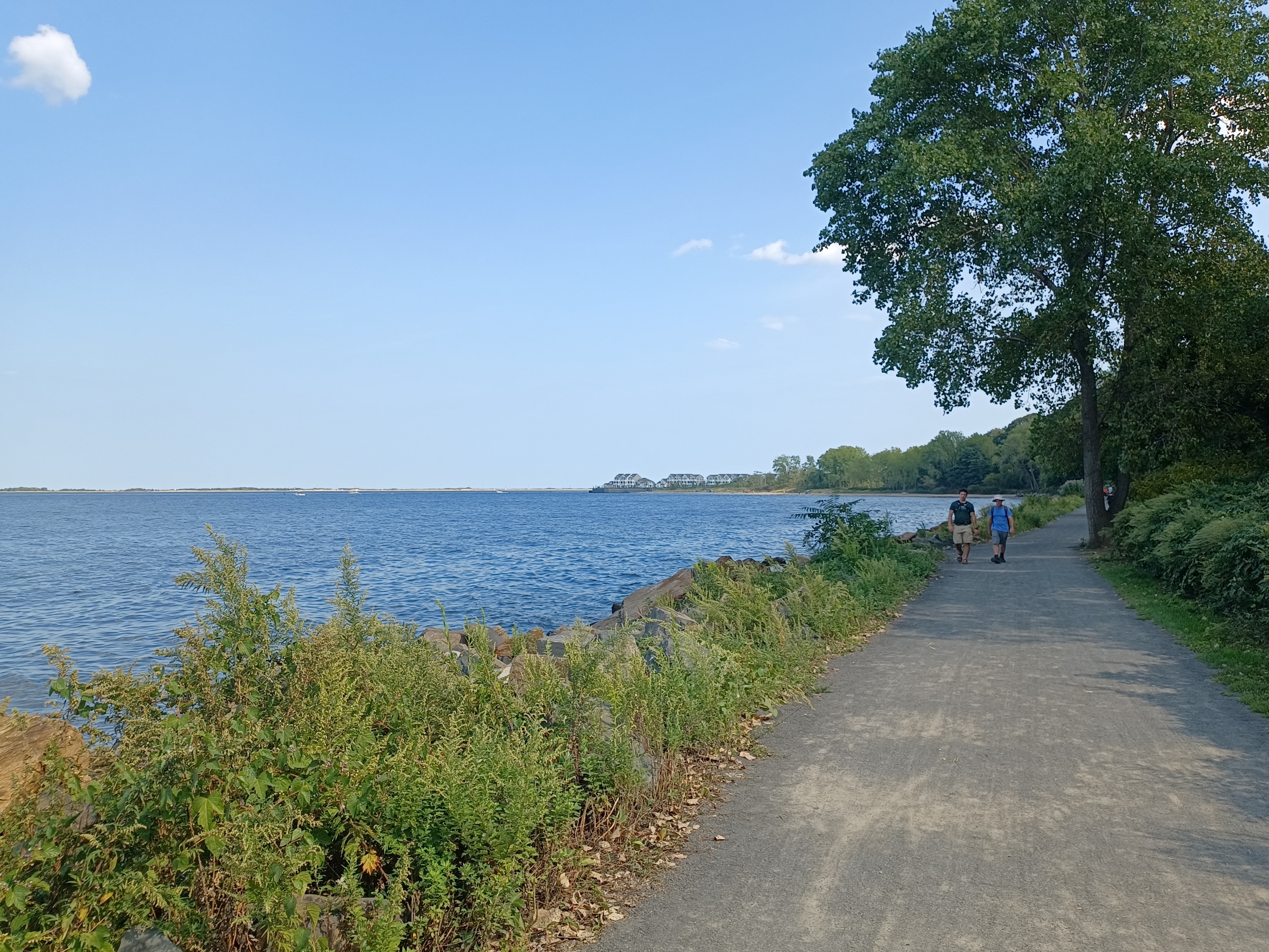
After our dip, we continued on the beach past lots of fishermen, and eventually came to the Henry Hudson Trail, in the prettiest section where it goes right along the waterfront.

The section of rail bed had a crushed stone surface, thankfully,
instead of the paved stuff we find further west on it. It led right along the
water, and afforded us views to Staten Island, New York City, the Verrazano
Narrows Bridge, and out toward Perth Amboy. I think the Watchung Mountains
might be visible on a clear day.
The first time I had walked this section, there was no trail there at all. We bushwhacked some of it, and otherwise walked along the rocks right on the shore line.

Joe Tag was there, and he bushwhacked through a huge mess of thorns.

I had only walked through on the section once since it was
completed as trail, and that was in the snow, so I really wanted to experience
it in the Summer and with clear views.
I figured if I got enough photos on the stretch, I might have
some good then and now compilations to use as well. I didn’t have nearly what I
was hoping for, but the section was really great regardless.
In this section, some of the locals were not happy about the trail going through.

They had had their own little private beach accesses (those who had them, many had no accesses at all) and liked it that way since the railroad closed down.

There was some fighting with Monmouth County over the
development of it. Some of the trail also washed out following the tropical
storms Irene and Sandy, but it is holding up well now.
Little Steven Van Zandt from Bruce Springsteen’s E Street Band,
as well as Sopranos fame I understand is one of the landowners that weren’t
happy about the trail development.
There were some properties with accesses, and one of them that was most impressive had a huge section of staircases going all the way from the home down to the water. I wondered if maybe that was any celebrity's house or something, but I'm not sure.

After a while out there, the trail becomes a boardwalk section. I guess the old right of way is completely washed away much of the distance here, and so they had to develop this alternative thing for the last section out to Atlantic Highlands.

When we arrived in Atlantic Highlands, the trail shifted away from the railroad bed, which utilized a series of piers with awnings for the station, and moorings for boats bound for New York City.

It was a really convenient and
beautiful interchange location, and to this day, along with Highlands, is a
pier location for the Sea Streak between New York City and New Jersey.
The trail moved inland slightly, or at least it seemed like it
was inland on the boardwalk because there was so much high vegetation growing
on either side of the trail.
There was a little side path to the right that we took out to an
outlook of the Raritan Bay which was quite nice.
The trail reached a fenced spot where boats are stored straight ahead. It was in this area that there were wooden piers that the railroad went out onto. The trail turned ninety degrees to the left for a bit, paralleled the boat area, then turned ninety degrees to the right. Just after passing by the boat area, it skirted the south side of Harbor Park.

The trail went across First Avenue and then turned left along West Avenue, where it regained the railroad right of way.

It was here that we
left the right of way for a bit to head south on First Avenue.
We continued south for several blocks to Washington Avenue. Just
about a block to the east on that is Carton Brewery.
I’d had some stuff from this place before, and it was alright. I checked their
website before this hike to see what kind of good stuff they made, and their
list was incredible. I didn’t know if it was something they always had
available, but the list was great.
It turned out they didn’t have almost any of the beers I was interested in from the list.
They were in a “Summer season” ales mode, which was mostly fruity and lighter beers, with lower ABV. Unfortunately, not one of the names I was interested in was available.

We first went to their outdoor bar, where tables were set up
like a beer garden outside. Everything offered outside was totally weak. They
said that there was a larger menu inside.
Serious Sean and I were interested in trying whatever was up
there, so we both went inside while the rest of the group went down the street
to a pizza place for a regular lunch.
We made our way upstairs, and I hid the beer I was already
drinking behind my back against my backpack. It’s amazing it stayed in there
for as long.
The rail bed in 2006

Sean and I chatted with the bartender upstairs for a bit about the beers, what was coming out, what was good, etc.

He was pretty cool, and
Sean and I chatted about what was in the future for us and the group, and all
sorts of stuff. It was a nice little break in the hike.
We eventually headed back down stairs, I think because we might
have gotten a call that we needed to continue on. Time was just flying by
faster than I could keep track of.
We were definitely running over the miles that I’d been planning
to do because of the side trip stuff we had done in Hartshorne Woods and then
some. I think it ran farther than I’d expected by a lot.
We got outside, and the group let me know that many of them had
left to complete the hike without us, or I think they Ubered out because it was
getting later. Only Stephen, Sean, Justin, Brittany, and I were left.
Just as I was walking away from the place, the beer bottle that I’d had up against my back fell out, and then shattered all over the sidewalk.

One of the young girls working the outside bar told us to get out of there, and started sweeping up the glass, and told us it wasn’t cool to be bringing in beer from other breweries.

I didn’t mention that I’d already been drinking it
when I arrived there! I tried to help with the glass, but she said to just
leave because we would end up getting them in trouble.
We headed back north to Highland Avenue and turned to the west.
The railroad bed from Highland Avenue to where it turned to the west was
obliterated and inaccessible to Avenue D.
Highland Avenue to the west crosses over the Many Mind Creek.
The interesting name to this creek owes itself to the early settlers who first
scouted the land in the 1600s. 
Promenade Pier at Atlantic Highlands, Rutgers Library
It was of the most importance to have fresh drinking water, both for human and animal consumption, and to grow crops, so to inspect the creek was one of the earliest things in area settlement to take place.

This particular creek changed directions so many times on its way from the foot hills of the Atlantic Highlands that they stated that it changed its mind where to go, and so “Many Mind Creek” was the name.

The creek goes along the edge of Fireman’s Memorial Field, which
I planned on walking across, but there wasn’t a really good way in to it. I
think we ended up heading through an opening near the ball field entrances, and
then headed to the south side.
Leonard Avenue was the road that it accesses on the south side, and that had a gate across it. I seem to recall we had to climb across it or something. I can’t quite remember what we did at that point!


When we got to Avenue D, we just had to turn left a short distance, and then right onto the trail on the old railroad bed again, which at that point was lined with fences from area businesses for a bit.

Pretty soon
though, it entered woodlands parallel with Route 36.
The wooded swath ended at Leonard Ave in Leonardo. I had hiked
through here I guess twice before, but never stopped to see the landmark that
was within sight and only one block to the north.
Just up the street was the famous Quick Stop, the setting for Director Kevin Smith’s breakthrough film “Clerks”. It spawned the “Jersey Chronicles” as we referred to them late in my high school days, and officially the “View Askewniverse” for Smith’s View Askew” films.

It was sort of tradition that the characters Jay and Silent Bob, who were introduced in the first film, would have a cameo in each film that would play a strong part in the plot. Silent Bob was played by Smith, and Jay Mewes basically played his eccentric self.

The first of Smith’s films I saw was “Chasing Amy”, and I found it to be quite
good, with very different and controversial characters and situations unlike we’d
seen in popular films before. A lot of stars were born through Smith’s early
works.
When Clerks II came out, and it exceeded basically everyone’s
expectations, Smith was back, after some more lackluster performances in
previous years.
Just before we did this hike, the announcement of Clerks III had just come out,
and Smith had been touring the country promoting it. Because of that, I decided
to make the Quick Stop one of our stops for the hike.

We went up to the store, and the video store that had been the next door over from the Quick Stop was no longer in place, but the Quick Stop sign just as it had appeared in the first movie was still there.

We walked into the store, and the counter was on the same wall
as the door rather than to the far left as in the film.
It really is a regular convenience store, and I was able to get
the Arizona RX Energy drinks I always drink for 99 cents like always. I kind of
expected more people would be wandering around through the place with Clerks
III all over the media, but we were literally the only people in there.
Serious Sean remembered some quote from the first movie, and went up to the counter to ask if they sold hub caps to a ’72 Pinto hatchback, and I took a video of it!
We moved on from that point, got a group photo outside of the
store, and headed back to the trail.
The trail weaved around more than the railroad would have as it headed west
across Thompson Street, and continued parallel with Rt 36. Some of the way it
was sandwiched between 36 and Viola Street.
We crossed Appleton Avenue, and then passed beneath the overpass for the
Normandy Road and Railroad.
The Normandy Road is the least traveled road in the state of New Jersey. This is basically because only military personnel are permitted to use it.

Naval Weapons Station Early was developed in 1943 when an
ammunition depot was needed closer to the New York Harbor. The Normandy Road
and adjacent railroad were developed for easy movement of this weaponry in case
of emergency need from the main base down in Tinton Falls to the Earl Pier,
which extends over two miles out into the Raritan Bay.
Even when I did the NJ Perimeter series, this section was one of the ones that I couldn't really get too close to because of the military clearance needed to get out there.

I’m sure everyone will say I was completely drunk or something, but if you’d read any of the previous journals, you’d know I was going through a whole lot more, which would turn out to be likely chronic Lyme.
The rail bed started to turn inland a bit more from Rt 36, and
just before reaching E Road, there was a pretty little pond on the left side.
It was not too terribly late yet, but we still had several miles
to go, and we had already done over fifteen miles. That meant I was perfectly
happy with quitting at any point since I’d done my target daily mileage.
I don’t recall if we stopped at E Road or Main Street or Church Street in Belford, but we definitely stopped in Belford and called for an Uber. It would have been more than three more miles to get to the end point otherwise.

We had a really cool driver who was ready to take all of us crammed into the car with no problem.

He chatted with us about driving and
being cool with people for the whole drive, and was just all around an awesome
guy. It was a great way to finish off the hike for the day.
I sat and rested in my car for quite a while before I drove off.
Although I don’t think I was really at all drunk, I definitely was drinking and
didn’t want to take any chances with endangering myself or anyone else. I ended
up taking a bit of a nap before moving on so my muscles could calm down.
I wasn’t doing as bad with the crazy fatigue as I had been a couple of weeks
prior, but I was still feeling the effects and getting some shakes here and
there.
Although the hike didn't hit all of the places I had hoped it would hit, it still felt like a really appropriate end of Summer good time as intended. We got to do some beach, got a little lost, got silly, laughed, drank, and walked, and I can't ask for much more out of a day to have these types of experiences with good people.
No comments:
Post a Comment