

Hike #1577: 11/5-11/6/23 Garrett to Ohiopyle with Jenny Tull, Serious Sean Dougherty, Galya, Professor John DiFiore, Jim "Mr. Buckett" Mathews, Eric Pace, and Major Tom Conroy.
This next hike was a long anticipated trip I had been wanting to do for a couple of years.


Actually, it was one I had wanted to do for years and years, and my obsession with connectivity led me to holding off on it for a very long time.

The Great Allegheny Passage is a popular trail, which connects Cumberland Maryland with Pittsburgh. I had first read about it in a trail book I'd gotten for taking the Appalachian Mountain Club Leadership Training in 2004.
At that time, I sort of fantasized about connecting to these places one day, but I was so far off.
Over the years, I worked on connecting across Pennsylvania through mostly backpacking trips with Jillane. We would go twice a year, branching out all over.


We eventually connected to the Mid State Trail, from which we could head west on the "Trans Allegheny route".

.jpg)
With little bits of other stuff in between, we took the Lower Trail and Allegheny Portage Railroad to Ghost Town Trail, to Hoodlebug Trail, to West Penn Trail, to Westmoreland Heritage Trail and Turtle Creek Trail, then other little ones to Three Rivers Heritage Trail into Pittsburg.


In addition, I was simultaneously doing another series on 911 National Memorial Trail, which overlapped this slightly, and I'd gotten as far as Johnstown on that.

I didn't want to just do the 911 Trail segment of the Great Allegheny Passage. If I was to set foot on it, I wanted to do the entire thing.
I had hoped Jillane would do the sections with me from the west, that weren't the 911 Trail, but she said "no, do it with your friends", so I did.
We had a great four day trip that first time, and covered everything from Pittsburgh back to Connellsville. After that, the section from Connellsville east took a while to get to.


I did the first section in the height of covid, and then Jillane became pregnant with my son, and it changed my ability to do this next section.

Since I started it with the group, I was certainly going to finish it with them.
The fall after Ev was born, we did a bit more of it between Connellsville and Ohiopyle, with another side trail, and on another trip, we did from Garrett to Cumberland in two days. I planned that first because the Big Savage Tunnel closes for cold months, and I wanted to be sure to catch that.
That last section between Garrett and Ohiopyle was haunting me like crazy.

I finally scheduled it as a group trip in rather short notice, but I had to get this done.

I found an Air B&B in the town of Confluence, and planned for one long day, one shorter day. We could base out of the house, of which I rented the entire thing for the group, and we'd do 25 miles the first day and 10 or 11 the second.
I knew the first day was going to be sort of a killer, but there isn't a lot of access points, and there is definitely limited lodging on that part. It was really the only reasonable way of knocking it out in two days.
It was nice and easy for me for the first bit, because Jenny offered to drive. I was prepared to take my Honda Element, but it has had some issues that I would rather not deal with so far away from home.

It was a pretty long drive, and we got to Ohiopyle after dark. Galya was there waiting for us, and Serious Sean hadn't arrived yet, but was signed up. Some of the group was only going to do the second day.

If I'd been able to plan it farther in advance, it would have been easier to gather more people, but for the first day it was only the few of us.
Serious Sean showed up really super early morning I think it was, and was sleeping in his car rather than bothering to come into the B&B. I think he couldn't find his way in or something.
Ev slept surprisingly well, and he wasn't really afraid of anything. He'd get up in the middle of the night and go down the stairs, which was rather funny. I had to chase him a couple of times.

In the morning, we shuttled out to Garrett, the familiar spot where we had been at the start of our trip to Cumberland. It was a relief to actually be on the trail, knowing that we were actually going to get this done.

I had a few more then and now compilations to get at this site when we started, and I let Ev out of the stroller to start walking the trip on his own.
The Great Allegheny Passage utilizes a few different corridors on its route. Out of Pittsburgh, it mostly follows the Pittsburgh and Lake Erie Railroad route to Connellsville, but it also diverges onto a few other bits of right of way. From Connellsville east, it is the former Western Maryland Railroad.


While we were in the parking lot getting ready to go, Ev was running around the parking lot like a lunatic as usual. He tripped in his excitement and face planted right into the gravel lot. He had a big scrape on his nose that I was really worried about. Fortunately, we had some wipes we could lean it out with, and he didn't let the scrape take away from his fun much.

I ended up getting a lot of shit for it though, because the scrape left a small, discolored scar that is still there if you look close enough.

Ev walked beneath the culvert underpass next to where the station used to stand. I had a look to the north, knowing that I'd be back to this spot one day to finish the 911 National Memorial Trail route.
The trail route to the north follows an old rail bed toward Shanksville, and back roads for there. I have a really interesting route that will take four days to walk between Johnstown and Garrett, with the Flight 93 Memorial on the way.
This trip could easily have been part of that missing bit, because what we hiked for these two days are not officially part of that 1,400 mile long triangle.

Things are different now though, and how this series has played out has really been on my mind. It has not been at all what I thought it was going to be in terms of support and interest.
.jpg)
As such, it was of much greater interest for me to hike the remainder of the Great Allegheny Passage than focus so heavily on the official 911 route.
I suppose this is as good a time as any to start discussing what's happened with this series, the trail, and the connections and disconnections that have happened through it.
It's probably a better journal to put it under since it's not really fitting in with that series anyway.

After I finished the Jersey Perimeter Series to great fanfare, it seemed like jumping on board with this incredible initiative was going to be the next big thing.

I could promote trail connectivity and at the same time elevate Metrotrails maybe to the "next level", whatever that might be.
The series started out very strong, in New York City, and brought in large groups as we continued across the state.
It was awesome to have the support of Morris County Park Commission as we continued through, with a slack wagon van piloted by Russ Nee, so we didn't even have to have backpacks with us.

When we reached Pennsylvania, the groups will still good, but not nearly as large. People really began to get disinterested when there were long distance road walks involved.

From the start, many people I thought would be involved through the trail groups disappeared.
I have been vocally critical about the route that was chosen, because in many places there were better routes to take. For one, routing people along Rt 611 through Delaware Water Gap is beyond irresponsible. There is no room to walk.
The trail initiative was getting hijacked completely by the cycling contingent, and the fact that there was no good place for walkers was often not taken into consideration.

At one point, a chosen route was changed when I sent screen shots to a moderator showing that pedestrians were not even allowed on one of the highways chosen as the trail route.

I suppose the final nail in the coffin for myself and Metrotrails, as far as that management goes, was the Essex-Hudson Greenway in New Jersey.
Governor Phil Murphy served as Chair and Vice Chair to two governors associations for which Norfolk Southern more than doubled their campaign contributions as soon as he took office, and which, as per federal Pay to Play laws, makes doing business with them illegal.
The state paid sixty million dollars for nine miles of rail bed to Norfolk Southern (over $300K an acre) after this, and the official response from the state was that they did not recognize federal Pay to Play laws.

I got it posted in the NJ Monitor, and stated that this kind of dealing sets a dangerous precedent for any of his successors.

Further, the outright purchase of this land, if railbanked, should not at all have been necessary if we were to follow past practice with rail trails.
A friend of over a decade, who I respected greatly and is close to this plan, blocked me on all social media when I called out that this deal was irrefutably illegal. I had stated that it would give a bad name to all trail development projects, and he responded by blocking me on all social media.
He could have deleted my comment. He could have sent me a message saying I didn't understand, or giving at least some sort of explanation as to why going through with this project, in this way, was worth it. But I got nothing but ghosted.

It was akin to being told there was no Santa Clause at the age of five. It was jarring disappointment. In time, it evolved into acceptance that someone I once held in such high regard was just another link in the corrupt chain of trash politicians out exploit money on the name of a good initiative.

No one is going to say "no" to anything 911 is attached to. This is sure to be a trail grant money pit for years to come, and to many of the key players on the route, that is a great thing. But it's not a great thing across the board.

The trail should never have gone through Delaware Water Gap at all. A bit slap in the face was a large meeting that was called to "decide" the route that would be taken across the western part of NJ into PA.
We were told after arriving that whatever choice was made, it had to lead to Delaware Water Gap, which meant there was only one choice and we had the meeting for nothing.
I suggested the southern route through Hunterdon County using Highlands Trail route rather than go up through the gap. The routes separated near Waterloo Village and came back together in Easton.

My argument was that the way they chose had 51 places where the road must be crossed at grade in NJ and 25 in Pennsylvania, most without crosswalks.

The route I proposed had only 22 in NJ, 2 in PA. Their route had over 25 miles of road walking, while the one I proposed had less than 10. Further, the route I proposed had more than quadruple the amount of historic sites of significance in America than the route that was chosen.
I found out later that the decision that was made was chasing grant money by several agencies. So, they chose an inferior route.
Today, I have no support really among the group except for a few really good eggs that have been the voice of reason, of passion, and respect.

Russ Nee is still great, and even the President of the organization, David Brickley, strikes me as a good man with great intention, but he has been stepping back from his role and letting others take the reigns.

By the time this hike came about, I've pretty much moved beyond this, but I won't remain silent about how good initiatives are exploited.
It has been clear that I don't need their group in order to enjoy these lands, and I certainly don't need these other organizations to share natural and historic resources. Even now, I have over thirty thousand more followers than the 911 Trail, and that blows my mind.
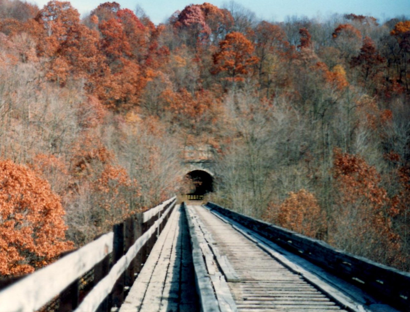
It was really pleasant right away, heading into the Casselman Gorge.

The Casselman River is smaller than the Youghiogheny, but not by all that much.

The entire first 8.8 miles of this hike had no road crossings at all. It was very quiet and secluded. We passed one house within the first mile, but then nothing for a bit.
There were lots of springs along the cliffs to the left, which had lovely little cascades.
We crossed over the Piney Run along the way, followed by the Lick Run, Shafer Run, and Stony Batter Run. There was one giant spring not far out of Garrett that had an enormous flow coming from it.

The entire time, the former Baltimore and Ohio Railroad was on the opposite side of the tracks. Trains would often go by while we were walking, and I would stop and point them out to Ev.

That, and lots of great views of the Casselman River were plentiful. It was the right time of year to do this one, or otherwise we'd have just been in a big green tunnel of vegetation. We had some great views.
The first settlement and station stop we would pass along this trip was the community of Rockwood, but before we got to that point, we approached the former site of the Quemahoning Coal Company.
There was once a loading area in this stretch as well as a water tower. I didn't notice anything of any of that, but there was a grade off to our left that might have been a siding to serve it.

Just ahead, we came to the former site of Rockwood Junction. This site was very obscure, but there was once a signal bridge here, a boiler house, and other little structures.

At this point, a branch line broke off to the right, north, to cross the Casselman River and connect to the former Baltimore and Ohio Railroad.
The bridge is still in place, but we didn't venture over to have a look at it. I kind of wanted to, but with 25 miles to cover on this trip, there just wasn't the time.
On the other side of the river, Baltimore and Ohio's Rockwood Junction is still active with a northbound track to the town of Somerset.


We continued ahead and soon reached the intersection with Rockdale Road and Markleton School Road.


We crossed over and took a little break, where there was a good spot to the right. I had several then and now things to set up at Rockwood, so it was a good spot to have a short break.

I let everyone know that this was literally the only spot on the entire hike where there might be a place to get more food or drink. Otherwise, we would be far away from anything else.
I would actually have liked to stop in Rockwood for a bit longer. A train went by on the other side as we walked through, and we watched it for a bit.
The station used to stand on the west side of the crossing, and I'd found several historic photos of it prior to doing this trip, so I got a few of them there, and a couple of them also at the junction area just to the east.


The settlement was initially known as Schaff's Bridge, and then Mineral Point. Philip Wolfersberger built his house in what is now Rockwood in 1856. In 1857, he laid out the town with surveyor Martin Meyers. In 1860, John Poister's hotel opened, and other amenities followed including a railroad station on the Baltimore and Ohio in 1871.


By that time, there was already a post office and a tannery, and more followed with the creation of the junction there.

The communities along this trail are very nice and catering to trail users. There was a metal fabricated sign from the "merchants" of town, and an old style bicycle on display on the trail, as well as an observation deck to the river.
There were several art installations along the way, including a train with bicycles at the west side. Another memorial to Maynard Ralph Sembower, the "Ambassador of Rockwood" Pennsylvania, who saw the Western Maryland Railroad through construction, abandonment, and development as a trail. He lived to 100, and spent his last 17 years engaging with visitors at the trailhead here.

There was also a really nice kiosk that detailed the route of the entire Casselman River.

As we headed west, there were more dripping springs form the rocks, just like when we left Garrett, and a little pavilion and a picnic bench on the right where there were more than two tracks at the town approach.
I let Ev walk for a bit again as we left the former station site heading west.
This was at mile marker 44. The entire Great Allegheny Passage is marked with nice cut stone mile markers, which must have cost a fortune.
There was some sort of switch box in the woods, and just ahead there was a pretty little waterfall on the left. Other than that, the miles just passed by in the next section.


It would be another 6.1 miles before we would get to another road crossing. In that stretch, it was just rail bed on a shelf above the river.


We did pass by one other small settlement, called Casselman, but it was on the other side of the river and totally inaccessible.


The rail bed moved away from the river briefly around mile marker 48, and went through a bit of a cut.


As we started to approach the small community of Markleton, which is barely anything but maybe a dozen homes and a road crossing, we saw evidence of sidings.


The first one was rather obscure, on the inland side, but the second one was rather obvious with some stacked ties supporting the right of way, where the first homes across the river started to come into view.


There was some sort of metal structure to the left that was associated with loading, but I'm really not sure what it was. There were no historic markers detailing any of what we were seeing there.

Soon, we crossed Markleton School Road and regrouped. I was moving at a pretty good clip and Jenny was pacing with me really well. Sean and Galya are not slow, but they weren't quite matching what Jenny and I were doing.
There used to be a bridge that carried the railroad over the road at Markleton, but it's long gone.
From this point, it was only about 1.8 miles to Pinkerton, the next point of interest. We remained pretty close to the river in this stretch, and eventually approached Pinkerton.
There were pretty rocks out in the river, and power line crossings that afforded us some pretty nice views across the river and to the former Baltimore and Ohio Railroad, with the trains occasionally passing by.
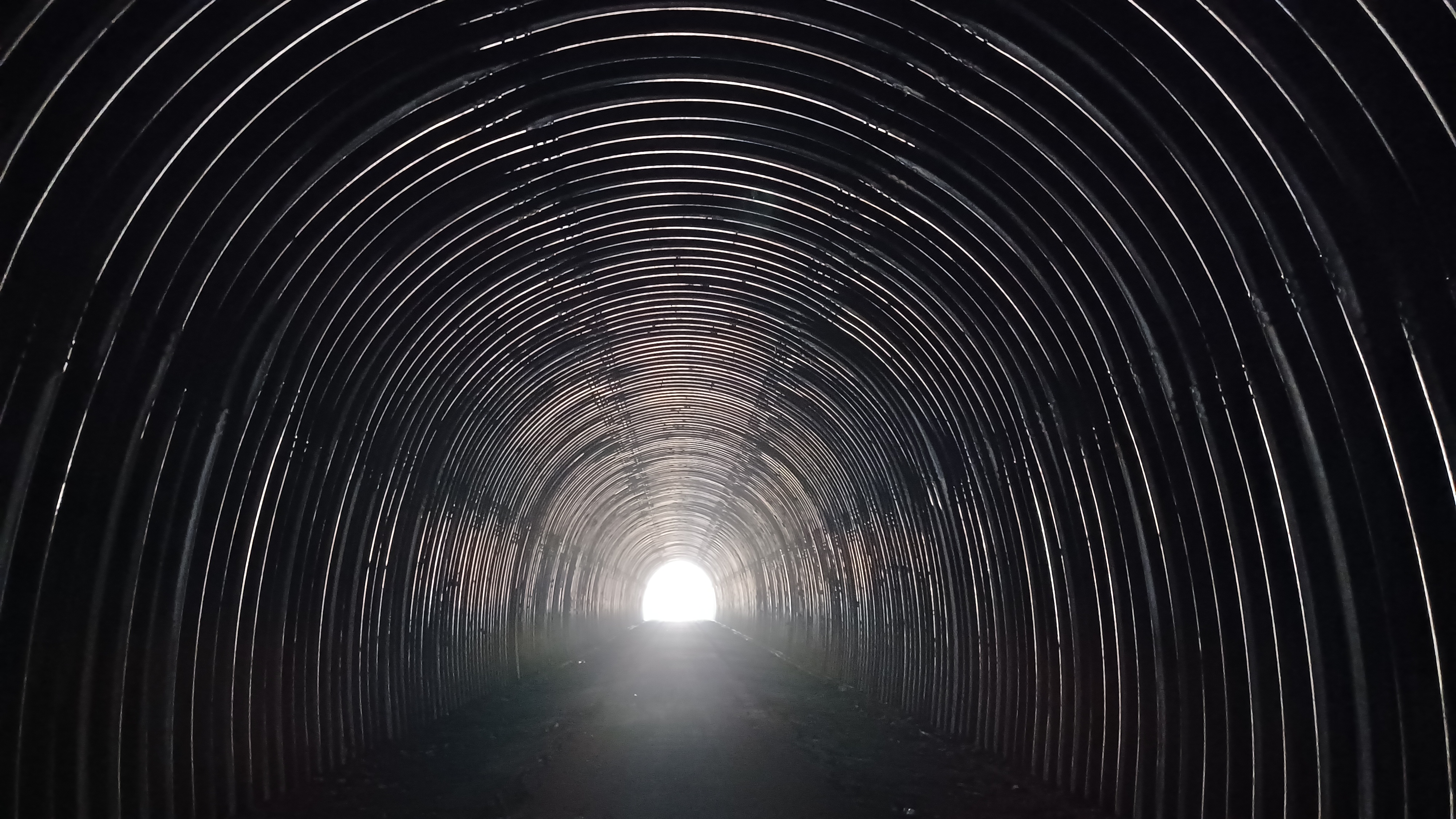
This is a really interesting area. There are two bridges and a tunnel on the Western Maryland Railroad: Pinkerton Tunnel, Pinkerton High Bridge, and Pinkerton Low Bridge.
Pinkerton Low Bridge came first, and this afforded some splendid views of the Casselman River.
We stopped onto the Pinkerton Low Bridge, and a train was passing by within view on the former Baltimore and Ohio Railroad just to the right of us, with containers stacked two high on flatbeds.


When the Baltimore and Ohio established itself through the Casselman Valley in about 1871, it too had a Pinkerton Tunnel through the mountain, immediately to the right of the one we were approaching.

The mountainous mass of land the railroads pass through, at the bend in the Casselman River, is known as Pinkerton Horn.
The C&O built its tunnel as a timber lined structure in 1871, but it was destroyed as a result of fire in 1879. As a result, they constructed another trail around the Pinkerton Horn, directly beside the river, known as the "Shoofly".
First attempts to put a railroad through on the land led to the surprise of already having tracks in place when they reached their tunnel location.
The original Pinkerton Tunnel was refurbished and opened, and the Western Maryland had its adjacent tunnel in 1912.
After it was abandoned, and most of the land had been purchased for the trail, the WM Pinkerton Tunnel was a problem.
The contractor that was working on one of the large bridge projects on the line was also to do the tunnel, but it proved to be a much more costly project than anticipated. That contractor backed out.
In the 1990s, a large slab of rock also fell from the roof of the tunnel, so it looked as though it would be cost prohibitive, and this section of trail couldn't go through.
Then, the concept of the "shoofly" came up.
An easement was granted from the landowner over the former Baltimore and Ohio "Shoofly" right of way, a distance of about a mile and a half, and the trail was able to be completed through.


This was not the end of the story though. The railroad wanted to daylight their active Pinkerton Tunnel to allow for the passage of double stacked trains, just like the one we were watching.

In doing so, they wanted to use some of the shoofly for access and land for dumping the waste rock material during the daylighting process. A deal was struct that would allow for the right of way to become public land in fee simple rather than through easement.
Not only that, but with the daylighting of the tunnel, and all of the damage that would likely be caused by it through all of the trucks loaded with rock and material on a daily basis going on top, the tunnel was also refurbished.
The tunnel is now lined with a sort of corrugated material, unlike anything I had ever seen done on any tunnel elsewhere, but it works.
In fact, I like the idea so much, that I have passed it on to several people in New Jersey for consideration of some of the tunnels in our area as well.
The railroad also chose to daylight a couple of other of their original Baltimore and Ohio tunnels, and one still remains refurbished.
Just before reaching the edge of the Pinkerton Low Bridge, I let Ev out of the stroller to run around like a maniac. He loves bridges and tunnels, so this was a good thrill for him to experience more actively.
We looked at the train going by and took a little break, then headed into the tunnel.
Ev was pretty brave about it. He walked right into the tunnel by himself and looked in. It wasn't all that long, and the other side was very clearly visible, but for a little two-year-old, it was something big.


He took Jenny's hand and passed through the tunnel with no problem, loving every moment.

We exited the tunnel, and immediately reached the east end of the Pinkerton High Bridge, as well as the other end of the "shoofly".
This bridge lived up to its name as having been the high one. Ev walked across this as well, and there were splendid views of the river way down below in both directions.
We got across, and I took several photos of the site for my then and now compilations.
Once out, Ev held Galya's hand for a little while and walked for just a bit more beyond the bridge. We then had to put him in the stroller to make some better time.


The views of where the old B&O tunnel had been daylighted were much clearer once we had reached the other side, and it was quite incredible to see.


It was desolate from here for 2.2 miles to the next little community, known as Fort Hill.

The river views were quite excellent in this section, and the lighting was getting to be pretty great.
When we reached Fort Hill itself, it was probably the least significant of the communities we passed through. There were no houses in view, and it was just an odd grade crossing with a switchback in the road.
It had been 2.2 miles from the Pinkerton High Bridge to this point, and Jenny and I had not lost pace at all, but Galya and Sean were slowing up.
Jenny and I paused briefly at Fort Hill crossing, and Galya motioned to us. I guess she wanted us to wait up for her, but she was pretty far back and within sight, so I didn't worry about it at the time.


I found out later she was really pissed at me for it. Ev was getting restless and wouldn't sit still though, so we really had to keep moving.


The next section was again really pretty, but it was another long stretch of unbroken wilderness, the longest one we still had left in this day, 4.4 miles.


Jenny and I pushed ahead, passed along shelves, and through cuts along the riverside. I wanted to at least try to get to the next crossing, Harnedsville, before dark.


Along this desolate stretch, there was a sign on the left side of the trail, well routed, with a no trespassing sign next to it.

It read:
"Welcome to the Allegheny Highlands Trail. Please enjoy your ride but respect the private property through which you are passing. Violators will be prosecuted."
The sign was well off of the trail to the left of us, at the slope. I was a bit confused both by the name, and the fact that it was over there so far.


I questioned whether or not this was an obscure side trail that goes through private property, that we're allowed to be on, which I might not have heard of before.

It turns out it was not anything exciting like that. The original name of the trail, when it was developed disconnected from the other sections, which collectively came to be known as the Great Allegheny Passage. It just kind of threw me off hoping there was some other obscure route I'd have to come back and explore.
We pushed on pretty quickly, and eventually came to the community of Harnedsville.
We crossed over the Casselman River on a decked plate girder bridge original to the railroad.

Once on the other side, we stopped for a long break to give the others a chance to catch up.

I had a few final then and now compilations I wanted to get at this bridge site, and so Jenny played with Ev a bit while he walked around the parking area.
The location was direclty at mile marker 59. Unfortunately, this area was so secluded that there was literally no cell service whatsoever. I couldn't check on Galya and Sean.
I got


Immediately after the bridge over the river in Harnesdville, the trail/rail bed crosses Hogback Road.

We started walking around a curve, and then the right of way took us beneath Listonburg Road through a culvert underpass that had been placed after abandonment of the line.
 |
| 1917 |

We continued on, and the right of way got to be perfectly straight for a bit. It just kept getting darker.
 |
| 1912 |

Ev had taken a nap during the trip, but he was somewhat awake and looking around as it was getting darker.


The trail came up close to Listonburg Road again, closely parallel, and the B&O tracks were just on the other side of that. Another line, the Whites Creek Branch of the Baltimore and Ohio, was also parallel with this section to the south of us, closer to the river at this point, but we didn't see much of it.


It was dark until we came up to the Luther P. Miller gas place, which sits at the former site of the Confluence Station on the Western Maryland.

From here, we climbed slightly, because the right of way was somewhat disturbed, and there was a bridge which might have been where this B&O branch used to pass beneath. It might also have been a road, but I don't know.
I had several photos I wanted to try to get of the former Confluence station site, but it was far too dark for anything good, which left me disappointed.
I immediately came up with a plan, that I would backtrack to this point in the morning while the rest of the group was spotting cars at the end point for when we were done.


We continued, and soon we crossed the Casselman River for the last time on the railroad bed before town (although I'd come back in the morning to this one).

It was a deck girder bridge, and quite eerie to walk over at night, but still nice.
We passed through a cut after crossing to the other side, and then descended to Robert Brown Road, Rt 281 in Confluence.
We crossed the road directly and continued on Old Robert Brown Road. This led to a pedestrian bridge over the Youghiogheny River where the older road bridge had been.
We turned to the right here, on Petersburg Road, and passed beneath where the deck girder bridge used to take the Western Maryland over the Youghiogheny for the first time from the east.


The section of the bridge over the road was missing, which is why it is not part of the trail here.

This settlement, because of the land around multiple stream confluences, was regularly inhabited by native people, and then by some colonists after that.
The town of Confluence itself was formed in the 1870s following the completion of the Baltimore and Ohio Railroad.
The place I had rented was called the Birdhouse Bed and Breakfast. It wasn't like the normal ones since I got it through Air B&B. It didn't offer us any prepared food or anything like others do.
Still, it was a great place to stay in. It was a nineteenth century frame house, upgraded with modern amenities.

We turned to the right on Dewey Street, then right on Sterner Street, where the house we had rented was at the end.
We unlocked everything and put our stuff inside. I changed Ev's diaper and got things in order, and then was heading out to see about finding Sean and Galya.
As we got outside, they were walking up the road just about to the house. Both of them had certainly had enough.


Honestly, I had too, because I was okay after about fifteen miles, but after the twenty mile mark, I was ready for it to be finished. I just wanted to knock this section out.

Galya was really mad at me for leaving her behind, and Sean was annoyed to be stuck back with her, because he felt responsible to not leave her alone out there.
It had been quite tiring, and Galya turned in to go to sleep pretty early. The rest of us stayed up, and Sean had brought with him Cards Against Humanity, which we all played.
I had brought a couple of bottles of wine to celebrate the first and toughest of the two days with. We ended up drinking all of the wine and feeling pretty good with all of this.
Ev ran around like crazy while we were playing, and was quite happy exploring the place that was new to him, as he had been the night before.


The previous night, Sean arrived in the middle of the night and slept in his car, so I was glad he at least stayed in the house and was more comfortable on the couch, because it got to be colder at night. Apparently the door was locked as well.

John showed up at some point and joined in on the games as well, and the night got to be a bit better.
There was a lot of stuff in the refrigerator and freezer, and I made up some frozen pizzas that I'd picked up at the local Dollar General. Ev ate some of that.
While we were sitting up, I got to hear some of Sean's experience about what hat happened while we were ahead.
They followed the right of way to beyond Harnedsville, but then considered taking some sort of a shortcut, and bushwhacked up from the right of way to the road when it was parallel. It ended up putting them at a little more distance, which is probably why they didn't catch up to us as quickly as I thought they would after Jenny and I had been waiting.
We stayed up somewhat late, but then got a good night's rest. Ev slept next to me in the bunk bed room, and John got the top bunk.

Ev woke up a couple of times and went down the stairs, but there was nothing for him to really get into. I was just hoping he wouldn't mess up Sean's sleep doing it.

In the morning, we would be joined by Mr. Buckett, Eric Pace, and Major Tom. The three of them had gotten a hotel room somewhere nearby that they apparently got a good deal on, which I thought was crazy because they could have stayed with us for nothing.

Tom and Eric started giving Buckett shit for it because they liked the look of the place, but oh well.

It certainly would have been funnier if the three of them were around for the night.
In the morning, some of the group headed out to spot cars, and Mr. Buckett and Major Tom and I headed out like I was planning to do, to get the photos I wanted to get of the Confluence station site.
Galya was too exhausted from the day before to join us for the second day, so she decided to drive home in the morning.
She was still there when we left, and said she would lock the place up for us. The three of us headed back out the way we came, out beneath the missing section of the rail bridge and south.

I got a few then and now shots of where that bridge used to be at the very start as well.

There was a little park next to the bridge area I'd not paid much attention to or even noticed the night before.
There were standing rocks, and then a book epitaph in the middle.
The book told the story of a young Colonel George Washington who had been sent to this valley to survey the area. A native American guide told him to note how the confluence of the Youghiogheny, Casselman, and Laurel Creek joined to form the shape of a turkey's foot.
This is why some of the area where the mountains touch the water is known as the Turkeyfoot Valley.

We continued across Rt 281 again, and then up onto the right of way where we had been the night before.

It was extremely foggy, and we approached the bridge over the Casselman River once again, but could barely see anything from it except for the river just immediately below.
Once we were across, we noted a set of steps that led down to the road to the left of us, and then came to the bridge site that might have been the other B&O branch. It seemed like the angle it turned at would have been too much for a railroad, but I'm not really sure.
Soon, we reached where the station used to stand. I got the shots I wanted to get, except I missed one of the station from the angle we were facing when we approached it, so I was kind of disappointed to miss it.


We looked around a bit, and then turned around to start heading back toward the bridge over the Casselman River once again.

By the time we got back to the bridge again, the fog was already beginning to lift and we had a much better view up and down the river than we had only a short time before.
Pretty soon, we emerged onto Robert Brown Rd/281, and I realized that the trail officially turned to the left along the road rather than went across.
I think this must have been a somewhat recent reroute. There was the dedicated pedestrian bridge where Old Robert Brown Road was, but that is not the official trail now. This is probably because there was no good crosswalk over the busy road.
We turned to the left, and there was a walkway over the modern bridge, which took us across the Youghiogheny River.


Timing couldn't have been better, because the others had just arrived having finished shuttling the cars. They parked at the trail lot nearby on the other side of the river.

The trail weaved to the left on the other side, and then back to pass beneath the bridge we had just walked across, and continued on the west side of the downstream Youghiogheny.
Just to the south of this location is the dam for the Youghiogheny River Lake, a huge reservoir.
There are more trails that pass through this area, and at one time, I was thinking of breaking up this hike series a bit in order to explore that area further, but there's just too much to do, and at more than five hours driving one way, I wanted to focus on getting the Great Allegheny Passage done.
We went under the bridge and continued to the footbridge over the river, and met up with the group.


We didn't have to do it, but we walked across the footbridge and back. That was a worthwhile side trip for me.

We had the time to goof off a bit on this day, because we were only doing ten or so miles. It might come to about eleven total.
After the 25 the day before, this was going to be a much better one. I was sad that Galya was missing the much more fun day of the two. This in fact was such a fun day that it really made the rough experience of the day before cancel out.
From the bridge, we could see the Western Maryland Railroad bridge over the Youghigheny (the one with the missing section on the east side).
By this point, almost all of the fog had burned off. There was a little bit still looming over the river, and it was looking like it'd be a beautiful day.
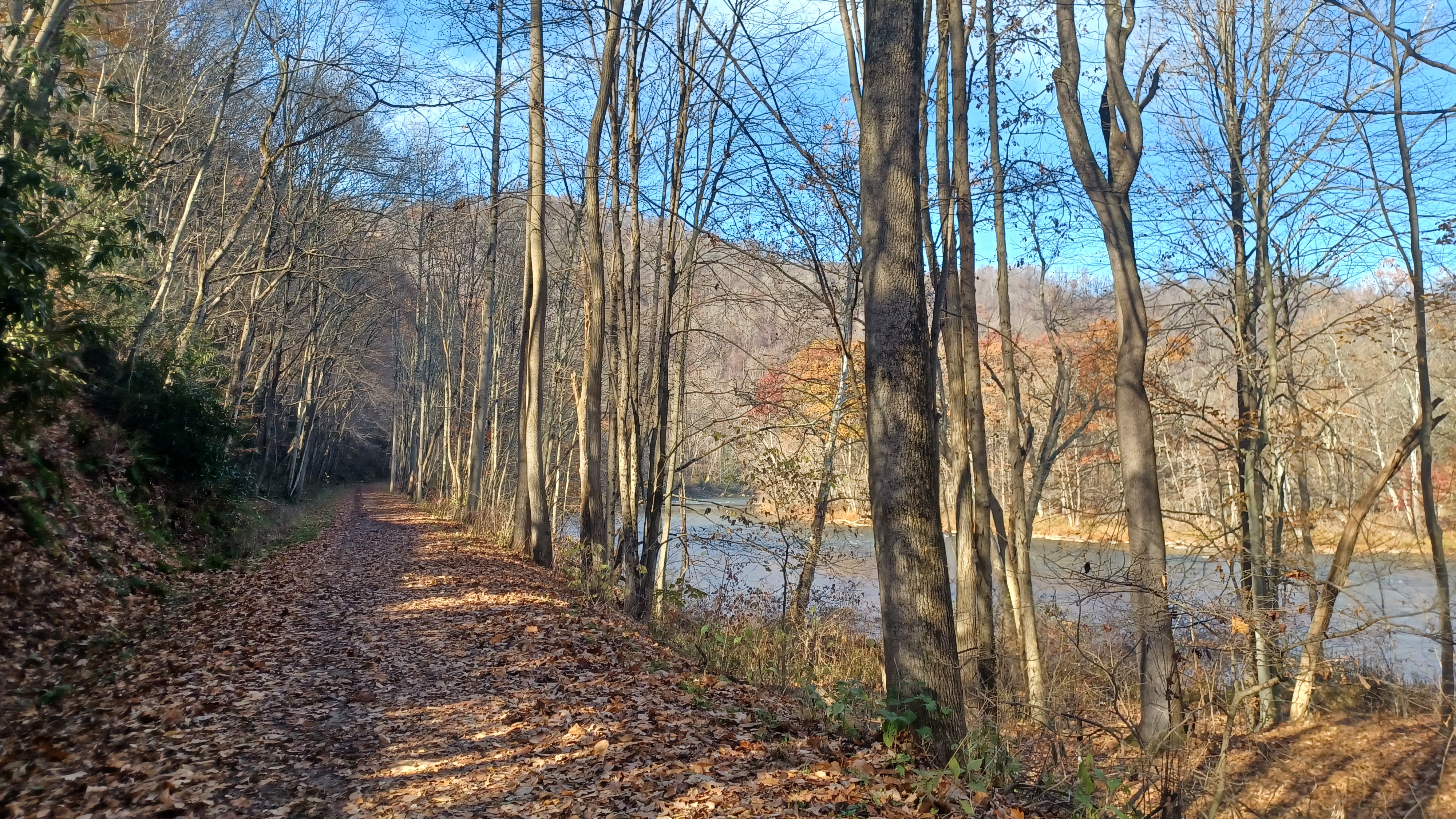
We continued back to the trail, which follows the west shore of the Youghiogheny, parallel with Ramcat Road on another rather forgotten railroad bed.

This was the former Kendall Branch of the Baltimore and Ohio Railroad, which was built in 1889 to serve lumber interests some twenty miles to the south in Maryland. At this point, we were actually pretty close to the Maryland line.
Today, not much of that right of way is at all recognizable, and a good portion of it is now under the waters of the Youghiogheny River Lake.
Some of it can be traced south of there, and some of it is now the Kendall Trail, but I've never been down there to explore any of it.
We walked north on this right of way for a bit, and soon passed beneath the former Western Maryland bridge. The rail bed continued to the left for a bit, parallel with us, but the trail did not initially return to that right of way. It stayed on the former Kendall Branch going ahead.
After a bit longer, we came to a point where we had a splendid view of the confluence between the Youghiogheny and Casselman Rivers on our right. There was a wide water area here, an the Laurel Hill Creek came into the Casselman just a short bit ahead. This was the "turkeyfoot" area.


When we came to the best view, a train was going by on the former Baltimore and Ohio line.

Just a little bit beyond this spot was the former site of the bridge that would have carried the Kendall Branch back over to the B&O main line. We did not note any remnants of a bridge here.
I'm not sure when that branch was abandoned, but it must have been rather early on.
Just after reaching where the bridge site would have been, the former Western Maryland line came back from the left, and the trail resumed following that for the rest of our trip.


Here, the right of way actually went a good distance inland. We crossed Ramcat Road, and then went along the edge of some cultivated farm fields for a bit.

Pretty soon, we reached and crossed Ramcat Road again, and then walked into the Ramcat Access point. It would be 8.7 miles from this point to the next access point in Ohiopyle.
We took a nice break here, and Sean found a pay phone on a building there. He pretended to make some sort of emergency phone call, which Eric thought he was serious about.
I had brought one bottle of Blasphemy to celebrate the end of this journey with. I only had a couple bottles of that remaining after all of the years I had been holing them up.


I think I had gotten this one in 2016 or 17 or something. They were a really good deal, and now there's no way I can ever find so many of them that cheap again.

From Ramcat, the trail went back along the edge of the Youghiogheny again.
It was a good distance remaining, but I felt like the entire remainder of the day was the home stretch. I was in really high spirits.
It's not all that often we got to actually completing a trail, especially one this long, which involved so much investment of time and traveling.
There were great views in this section like the day before, but this day had access points down to the river. Sometimes, they were even nicely built wooden steps.
One in particular, where there were big rocks across from Paddler's Lane Retreat, was worth going down to and checking out more closely.
This was a beautiful spot, and some of us went out onto the rocks while Ev stayed with the others up above.
I went out and stood in the water for a bit, which felt really good on my feet after the punishment I put them through the day before.


After this break, we let Ev out of the stroller to run around for a bit. We were doing well enough on time that he could walk for a while.

He meandered along, and wanted to touch all of the signs along the way.
Mr. Buckett was in rare form talking all sorts of hilarious stories that the miles just fell away.
I wish I could remember all of the stuff that was discussed, because it was just hilarious.
It was the last wilderness stretch of this trail remaining, and it just went by in no time.
Part of me didn't even want it to be over too early, and I was ready to do bonus miles around the Ferncliff Peninsula Natural Area from where we were parked, but then again, there's so much more I want to do near the end.


John carried Ev on his shoulders for a bit of the time, and we watched when CSX trains went by within view across the river, which made it more special for Ev.


Soon enough, we reached the parking area in Ohiopyle, and the trail skirted the left side of it, which was probably rail yard.


We skirted parking areas out to Sheridan Street, and then came to the old Ohiopyle station, which is revitalized as a trailside business.


There was plenty of time, so I recall we went down from the trail to the Falls Market Restaurant to have some dinner before the close of the hike.

I seem to recall getting a burger or something, but I could be wrong. But we ate and Ev had some of whatever it was that I had.
There was outdoor seating at the place, which I recall utilizing so that Ev could more around more freely.
While he was occupied in the enclosed eating area, I went around and got some of the historic shots I wanted to get below the old bridge.
Once we were all done, there was a set of stairs up by the station. I recall I went further around with Ev, back up to the station the long way so that I could prepare some more then and nw compilations of it. Sitting down gave me a little bit of time to get things in order for that.


Ev took his shoes off, but we let him get out and cross over the bridge over the Youghiogheny ahead barefoot.


We had started the previous hike at this location, just below the bridge, and we had plenty of time.


The pedestrian bridge over the river has been placed on the old piers from the long removed predecessor, and it sits up higher so it is not a flooding issue.


We continued across the bridge, and then Jenny stayed with Ev for a few moments while I went back down under the bridge on the other side to get the last couple of the historic comparison shots I had.

A path soon led down to the right, to the Ferncliff parking area where our hike ended.
I felt really overjoyed to have completed this section, not so much because it was any amazing accomplishment, but because we'd organized the trips enough that we were able to get out there to finish.
The Laurel Highlands Trail also ends right about here, and I want to do that, so I'm pretty sure I'll be back one day, but for now, and as long as Ev is in the stroller, I was happy to be finished with this stretch.


It was a relaxing drive back home, where I was passenger much of the way in Jenny's car, and I could focus more on my obsession to complete the entire Chesapeake and Ohio Canal.
There's still that bit of the 911 Trail that I will return to between Johnstown and Garrett, but I'm really not in a huge hurry to do that.
There's plenty more stuff to be excited about. An end of one thing just makes room to obsess on the next one.
No comments:
Post a Comment