

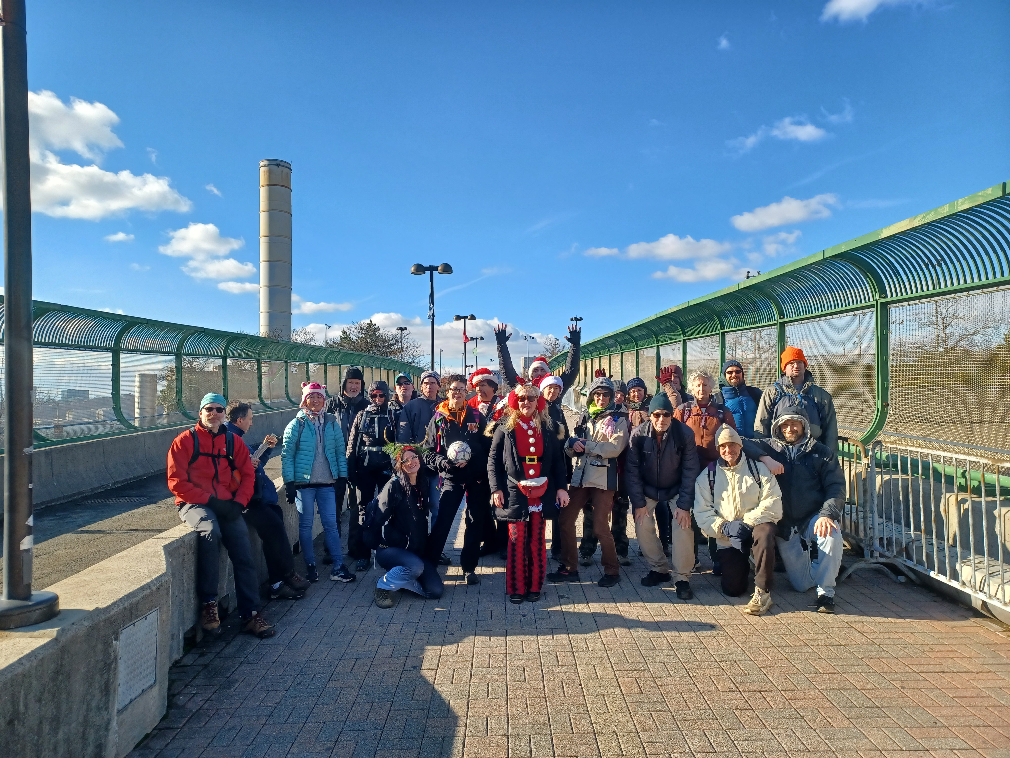
Hike #1521; 12/18/22 West Manhattan with Justin Gurbisz, Brittany Weider, Evan "Joe Millionaire" Van Rossum, Mark Norman, Lynette Dorsey, Steve Sanbeg, Jack Lowry, Sarah Jones, Serious Sean Dougherty, Jenny Tull, Jim "Mr. Buckett" Mathews, Eric Pace, Professor John DiFiore, Diane Reider, Robin Deitz, Violet Chen, Violet's husband, Carolyn Gockel Gordon, Mike Heaney, Dave Goldberg, Stephen Argentina, Bobbi Landrock, Anne ?, ?, ?, Chris Herbig, ?,
This next hike would be our annual tradition of hiking in New York City for the holiday season, which is always a well-attended event. For me, it is sometimes a bit of a pain to coordinate because it begins to feel like an obligation rather than a joy, but this one worked out quite great.

I've gone through so many life changes over the past two years, becoming a father, and navigating through life in that regard as well as through work and all. I definitely appreciate the sense of family and celebration that comes along with this hike and why people want to do it so badly.
With every negativity or major changes that come my way, I have looked at them as opportunities to do different things rather than inhibitions to things I have planned.
The only time that I struggle with this notion is when there are individuals who demand a greater level of control instead of adjusting to make any accommodations.

Wanting peace and wanting improvement should not be such adversarial concepts, but somehow, they tend to be all too often.

I planned this hike to be stuff that we could do with the stroller because I wanted to bring my son Ev along, but then his mother very strongly didn't want me to. I've brought him certainly more dangerous places than the west shore of Manhattan, but I relented on this one because if it ever did come down to a court case or something, a group of ignorant Warren County jurors would likely consider any trip to NYC to be dangerous and irresponsible.
Since Ev wouldn't be there, I changed the plans for the trip a little bit to cover some other places that wouldn't be so easy to do with the stroller, so here I made the best of it again.
This hike would fall on Justin's birthday, and he loves urban hikes, so it was perfect for that as well.

When it comes to all of these annual tradition hikes, one might think that there could not possibley be any more ways I could go about doing hikes through this area without covering the same ground, but there is actually a whole lot more I have never done before.

The idea behind most of this one was to follow the west edge of Manhattan Island along the Hudson River waterfront, but to do so not directly on the waterfront. There are at times three separate parallel trails that can possibly be taken to head north. I wanted to hit as much of this as possible.
For years, the holiday hike always met at the big tree in Penn Station and we would go somewhere from there. I had changed things up at times in recent years, but starting in 2020, I wasn't going to have anything to do with downtown Manhattan because of all of the pandemic stuff.
So, in 2020 I had a hike that took us from east along the northern bays, and only cut across Manhattan at the north end after dark, and in 2021 I made the hike start in NJ, then head onto Staten Island, and up to NJ again, so Staten Island was all of NY City we'd be on.
Those ended up being great hikes, and they felt more like proper hikes than the crazy holiday NY City stuff. I was quite happy with it.

I wanted to have something that was a happy middle of the road type of thing between the past and what we had been doing. I think we pulled that off pretty well.

I got up in the morning and headed to Short Hills Station, which is one of my favorite places to board, and met up with Mr. Buckett, Eric, Joe Millionaire, and Bobbi there.
Had I been able to bring Ev with me, I would have gone to Summit for the train because it has a handicap accessible on ramp I could do easier with the stroller.
I arrived early to get all of my stuff together and buy tickets. Diane ended up buying mine for me, so I didn't have to pay anything. When the train arrived, I left my Arizona iced tea on top of the ticket machine, and announced "Ah, it'll be there when we get done.

We hurriedly get to the top level of the double decker train and were on our way to Manhattan. The ride went quite quickly.

We got to the station, headed upstairs, and made our way out to the big tree area where we always meet for this. The normal spot we walk up to had a white tree and display, while the traditional style tree was placed to the left of that spot. I could see a lot of the group already there at that point, so we went over there.
I recall having at least 25 there almost immediately. Others were running late catching up. Sean had to go find batteries for his electric guitar, Stephen slept through his alarms, and then a new guy named Anker could not find us or the tree. We waited for him, but he forgot to bring his ID, and ended up going home.
When we were finally ready to go, we headed up to the street level, and I started trying to make sense of which way we needed to turn. Fortunately, Steve works just a couple of blocks away and was able to direct us to a plaza to walk through to get us out toward the waterfront.
Steve led us through a plaza area adjacent to the Manhattan West building, and we went by the location of a project he's working on which is a paddling piece of exercise equipment. Other ones like a walking and jogging treadmill thing were also on displays in the windows.

We meandered through the place, and passed a few stores. There was a skating rink actively being used that we walked by, and made our way out to 33rd Street and headed west. The reflective glass of the buildings made for an amazing ambiance through these areas.

We went a couple of blocks, then cut to the left a bit. I had originally intended to hike a short bit of the High Line, originally the New York Central elevated right of way that was built to eliminate some of the deadly car plus train accidents that occurred so often along tenth and eleventh avenues. At the time, both streets were given the monicker "Death Avenue".
We ended up one block too far north to hit the High Line, but what we did get to see just to the south of this location was an oddball thing I'd wanted to see known as The Vessel.
The Vessel is an odd honeycombed sort of shaped structure that is either eight or sixteen stories high, dependign on how you look at it. There are sections of it with stairs, and they go up what look to be partial levels. The structure has 154 flights of stairs, and I would have loved to go up it, but it is now closed.

When it first opened in 2019, there were three suicides from the structure, and it was closed down. It was reopened in 2021, but after yet another suicide, it was closed down again. I've heard that the structure is going to be scrapped rather than try again, but I'm not sure what the truth is on this.

We turned right and crossed over part of the West Side rail yard, then turned to the left down 33rd Stree, which was lined with police and parking officer cars all pulled in across the sidewalks and such in a peculiar manner. This must be some sort of staging area they use. While we all walked down the center of the road as a group, I noticed that police cars were pulling up behind us and trying to get through, but we couldn't walk on the sidewalk because all of them were blocked by the patrol cars.
We continued on out to the waterfront, crossed over 12th Avenue, and got on the Hudson River Greenway north. We paused when we got to Pier 76 Park where there was a giant propeller on display.

This was one of four propellers that drove the SS United States, which operated passenger service from 1952 to 1969. The boat to this day holds the transatlantic speed record in both directions.
It was a very popular way of making transatlantic crossings until the airlines became more popular for speed and convenience.
The ship itself is moored on the Delaware River in Philadelphia with hopes of restoration, but I understand it has been pretty badly gutted of parts over the years. It had been taken out of service and then other groups tried to revive it, but to no real avail. It was going to be scrapped, but then another group came along in Philly and is hoping to make something of it.
We continued walking the greenway to the north along the waterfront and parallel with 12th Avenue for a bit, and we didn't bother going all the way out any of the piers through this area because it would take so long, and I had a lot of stuff I'd been wanting to see.
Pretty soon, we passed the Intrepid Sea, Air & Space Museum, which is now an educational site aboard the historic USS Intrepid, launched in 1943 and decommissioned in 1974. It survived World War II with kamikaze strikes and a torpedo strike, as well as the Vietnam War, and later served as a NASA recovery vessel.

I would love to do the tour of the Intrepid, and all of the stuff that goes along with it, but I would have to plan one of these hikes around doing just that, and incorporating the tour into it. It would probably be a good thing to do as a group, but maybe not the Holiday NYC one.

We continued along the waterfront, which was nice, but this section is much pretty close to the street. It didn't really start getting interesting until we reached the Locomotive Lawn and Solstice Beach area.
The New York Central once followed along the waterfront through this section for loading and unloading from boats, and there is an old deisel locomotive on display to the right of the trail. The Solstice Beach section has some pedestrian bridges leaning out onto the water which makes for a very pretty scene. We had great views through this area over toward Hoboken in New Jersey.
We passed through a spot known as The Sanctuary, and then Linda's Lawn. The trail became lovely boardwalk over some grassy stuff which was also quite nice.

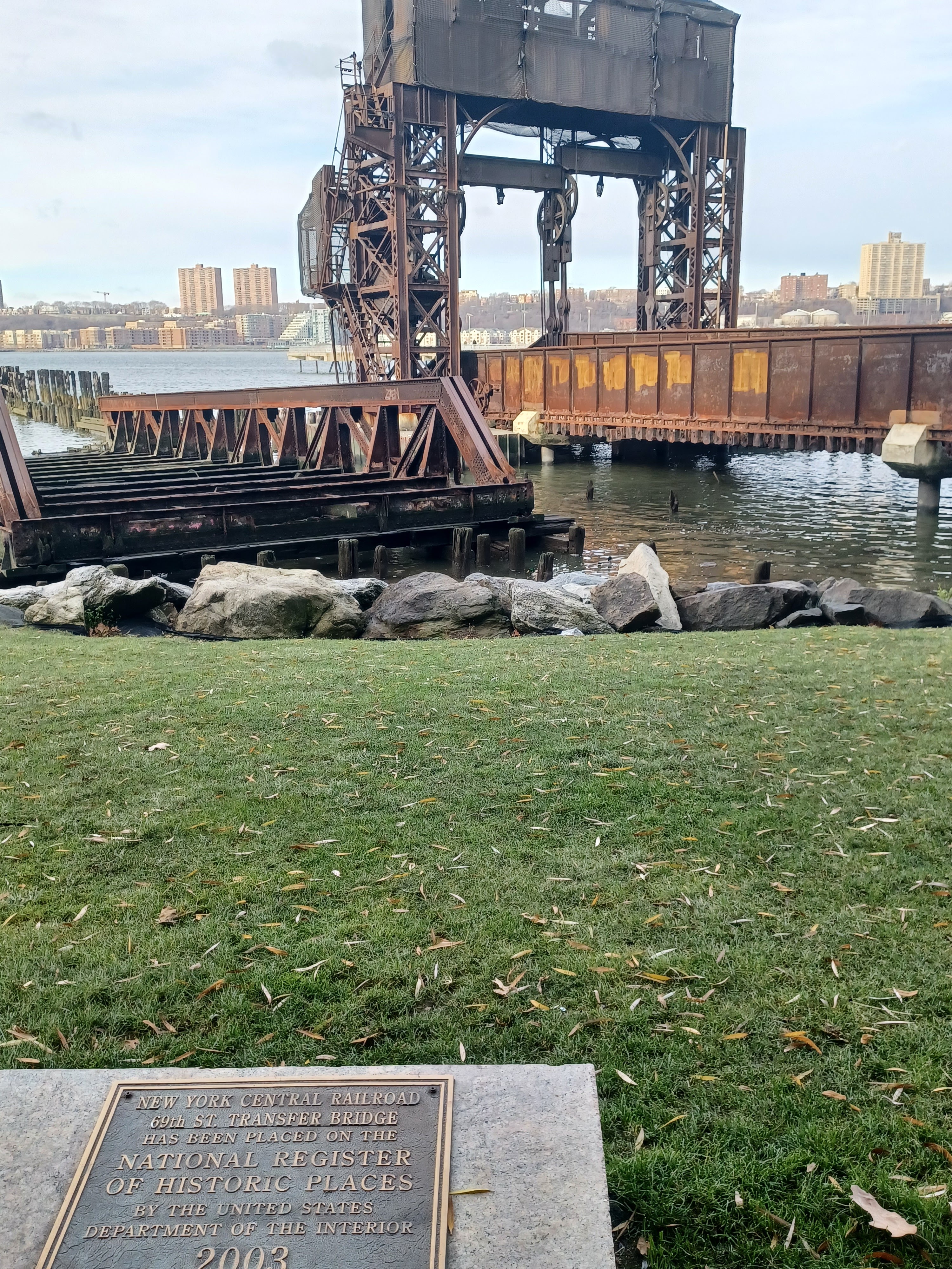
Just ahead, we came to the long abandoned 69th Street Transfer Bridge, formerly of the New York Central Railroad. I believe this was built in 1911 as a car float operation to bring needed freight across the Hudson from New Jersey. I'm not sure how long that has been out of service for.

There are apparently plans to restore the 69th Street Transfer to some sort of working order as an historic site, but I'm not sure what any of the details of it are.
We continued on the waterfront as far as Pier One, which was a particularly long one out onto the Hudson. It had been totally done up for pedestrian use, so I figured we should go out at least one of them, and Sarah said she really wanted to do it, so out we went.
The views were fantastic out at the end, down the Hudson toward Jersey City and Bayonne, and up to the George Washington Bridge in the distance. We admired the view from the end, and then headed back inland. It was in this area that I planned to head further inland and do more of the middle to upper sectios of the Riverside Park, which I'd barely done any of before.

I think when I first hiked the waterfront back in 2009, it was necessary to go up a level for just a short distance, and then came back down to the riverside, but more was added since then.

As we moved inland a bit, there was a truncated remnant of the Miller Highway, or West Side Elevated Highway, near 72nd Street, with no roadway, only arched steel framework.
The highway was built and opened in stages starting in 1930. The last section was completed in 1951. It was named the Miller Highway for Manhattan Borough President Julius Miller, who was involved in planning.
The route eliminated 106 grade crossings of the New York Central Railroad over 84 blocks.
The elevated Road was almost immediately obsolete in that it was far too narrow. Use of salt and other natural corrosion from moisture along the waterfront led to the deterioration of the structure, which resulted in a bus and car falling through a collapse in 1973.

Some of the structure remains in use today, but most was demolished and replaced by more modern Highway designated 9A, though there are local identities such as Henry Hudson Parkway and Joe DiMaggio Highway.

This point we had reached was on or close to the spot where it changes names to Henry Hudson Parkway, and segments are usually collectively referred to as the West Side Highway, although that name is in no way an official designation.
When we were on the path beside the old highway remnant, Stephen showed up on a Citibike. He had rented one in order to get to us faster after he got off the train and the subway, and then just needed to find a spot to leave it.
Once we were all together, we wandered a short distance ahead inland, and viewed into the over two mile long railroad tunnel known now as the Freedom Tunnel.
The 2.6 mile long tunnel was an enclosure of the freight line of the New York Central Railroad, the same that connected to the High Line further down. It was a Robert Moses plan where park land would be developed on top of the tunnel, and it would help to eliminate more grade crossings.
The name "Freedom Tunnel" has nothing to do with 911 or anything like that, but rather for graffiti artist Chris "Freedom" Pape, who used the walls of the inside of the tunnel as his personal art canvas.

Justin had walked through the entire tunnel before. He said it was quite easy and that you could probably cram ten tracks side by side through, though we'd never see any of that.

There are apparently two tracks inside the tunnel today, and we could barely seen any of that from our vantage point behind some chain link fences. Justin wasn't even sure how he'd gotten into the tunnel when he did it. We didn't have time to search for it, now did we really want to try to get through it with such a huge group. There was no way that would turn out well.
We headed back the way we'd came and passed beneath the abandoned highway bridge remnant again, then turned right to climb steps up along the Henry Hudson Parkway. These led us to a stone culvert underpass of the highway, and then out to more park land near West 72nd Street.

We started heading north through the park land, and paused when we got to a ball court on the right with a restroom along side of it. I had to pee pretty badly after being out in the open for so long.

The section of paths ahead was very relaxing in a slightly more wooded environment. We were never far from streets, but the topography and the amount of trees gave the illusion that we were not in Manhattan.
We continued north and reached 79th Street, which we crossed at a crosswalk. We entered more pathways on the other side, and soon reached the River Run Playground. There, there was another restroom building we paused at the relieve ourselves again. The group kept going ahead, but Brittany, Joe Millionaire, and I took advantage of the restroom.
When the others realized we had made another pit stop, they wanted to go back, so we opted to wait in the nice wooded area.

Joe Millionaire pointed at a large rock ahead of us, which stood much taller than anything else of natural height we had seen, and said that he'd really like to go up it. I agreed and hurried over to climb to the top.

Pretty soon, just about everyone was following us to the top of this bedrock outcrop of puddingstone and/or Schist.
I found out that this site is actually called Mt Tom. There were a couple of kids and parents up there when we arrived, but I think we scared them off.
We came back down off of the rock, and continued to the north where the trail became a sort of parkway road with a median. I suspected that this must have originally been a leisure driving road because of how it looked, with two directions on it. They probably cut the traffic out of it after the age of the automobile was in full swing and it started to be an impediment to pedestrians, and for that matter, relaxing altogether.


This was the esplanade of Riverside Park, built on top of the New York Central Railroad tunnel that stretches from 71st Street roughly to 123rd Street.

There was a good slope down to the left of us with more park land at a lower level. We were basically in the middle of three areas of park. Below us, we saw The Traveling Rings, near 106th Street. This was a sort of playground where one could swing from sections of rings, one by one like a Tarzan sort of thing. The group wanted to go down, but we had a long way to go, so I asserted that we would have to come back again. There is, after all, still an almost totally different hike we could do between these places.
We continued ahead, and along the way someone found a soccar ball I think it was. They might have found it a bit earlier, I just can't remember. The group started kicking it along as we walked, and it ended up staying with us for quite a long time.

Often in this section of the trail, such as in the median or off ot the side, there were vents for the railroad tunnel below. Justin leaned over one and we could plain as day see down into it and every bit of movement.

As we walked, on the left we came upon the Peter Jay Sharp Volunteer House to the left. It was a rather odd looking structure and seemed out of place with everything else we had been seeing.

Originally, it was a one-story of limestone structure over a century old. Using the existing structure and enlarging the footprint a bit, then adding a second story, the Riverside Park Conservancy created the only building in New York City dedicated entirety to sustaining and encouraging volunteerism in parks.
Apparently, the place can be rented at times, but nothing has been happening there because of the pandemic I assume.
We started following the upper trail to the right rather than the one that was more like an old roadway, because I wanted to soon ascend to the right. One of the highlights of this hike was something I had been wanting to visit for a very long time but never got around to it: Grant's Tomb.
We continued along the slope with a high wall to the right of us, which retains Riverside Drive. Evetually, there were steps to the right, which led us up and to the road, across from the green at the approach to Grant's Tomb, officially General Grant National Memorial in the Morningside Heights section of upper Manhattan.


Upon his death in 1885, Grant's widow declared that he wished to be buried in New York. He wanted to be interred beside his wife, and at the time, this would not be possible if he opted for a military cemetery like Arlington.
The Tomb was designed with unmistakable military character by John Hemenway Duncan. A temporary tomb was used near the site until the permanent structure was completed in early 1897.
We quickly ran across the edge of the road and entered the long pathway into the park area, where the tomb was straight ahead. We headed straight over to it and climbed the steps to the dome.

Unfortunately, there was a sign reading that the place was closed because the employees were away for lunch, and that it would be open again in about an hour. We really couldn't be waiting around for that long, so we decided to just continue on.

Surrounding the monument was mosaic folk art titled "The Rolling Bench", a series seventeen benches designed by artist Pedro Silva and architect Phillip Danzig in the early 1970s.
NYC Parks cites that the art contrasts strikingly with the tomb's severity. It did seem almost odd that this multi-colored ceramic looking material surrounded the very serious looking structure.
The art chairs were restored in 2008, under direction of one of the original artists.
We continued to the north from the tomb, and soon reached the Riverside Drive Viaduct, aka 125th Street Viaduct on the west side, which crosses over the Manhattan Valley, at a little community of the city known as Manhattanville.
The bridge was completed in 1901 with 26 arched spans or bays. It has been reported via my posts on this topic that the bridge was entirely razed and all steel replaced, but I haven't read anything saying that specifically.

The detail that has be cast any doubt on this is the fact that the arches look to be from the early 1900s, and a more modern bridge would pobably not look so attractive.

The abutments were made of Mohawk Valley stone, and the near side has a very nice stone archway to it.
We walked down the stairs from the edge of the bridge to the bottom; I did'nt realize that it would have been smarter for us to walk over the bridge, because we'd have been afforded a great view and gotten to the trail on the other side so much faster. Still, we saw good stuff going briefly along the waterfront again too.
We descended from the park along what are known as the St Clair Stairs to St Clair Place, past the lovely stone arch along the start of the viaduct. There were some really nice views of the bridge structure here as we were descending.

We headed out to the waterfront, where we again had some good views up and down stream. On a dock area here, there was an old military style vessel moored on the Hudson.

This was the Baylander IX-514, which now serves as a floating bar and restaurant, although nothing was going on while we were there.
Up river, we could see the North River WPCP, a water treatment plant.
We walked the West Harlem piers along the waterfront and continued to the north for a bit more. We cut to the right near the end of the viaduct and headed inland, then climbed yet another set of stairs along the edge of it. The views of the bridge at this angle were really pretty cool.
The railroad was out of the tunnel by this point, so we went under that, and continued up the steps into the next bit of park land to the north.
 |
| Eric K Washington collection |
We paralleled Henry Hudson Parkway on the east side of it, and Riverside Drive was to our right.

We continued along the path ahead, and soon crossed over an entrance road to an active recreation area situated on top of the water treatment plant.

We figured we would check it out since it looked like we could walk there. We meandered slightly out onto the thing, and there was a guard shack. It didn't look like anyone was in there, until we got close and we could see the guard was fast asleep! We just meandered on by, and then did another group shot on the bridge facing to the west.
I didn't want to stay out on the active use area, because the area along the park section up the slope, like what we had been following before, appealed to me more.
We continued north for a while, and I watched closely on the maps where Broadway, the most prominent street on Manhattan, comes closest to the park.

There is a stretch where it is only about one block from the trail, and at that point it made the most sense to go inland and get something to eat. It was an area that has all sorts of food places, so it would be perfect.

I let everyone go ahead of me at 147th Street, and I told them not to take too long because we had a long way to go. I continued up the trail ahead, and then cut the block in to Broadway myself when I reached 148th.
I was about to go get some fast food somewhere, and a lot of the group had gone into Jin Ramen. Serious Sean came out and told me that they were all going to eat there and then take a cab to catch up with us later. I told them they probably wouldn't be able to find us, and showed him on the map how it becomes pretty much impossible to get to us because we'd be sandwiched between highways and railroad tracks where even walking directly down to us would be prohibitive.

Sean went back inside and the came out to grab me and pull me in. Jenny offered to buy me ramen if I stayed put, which I really didn't want to do that badly, but ramen is good, and it was actually still quite early.

I think it was only about 1 in the afternoon, and my goal was to get to the Henry Hudson Bridge before dark. It was important to me that we do the complicated section north of the George Washington Bridge on this hike, and if we could do at least that before dark I would be happy. Judging by the maps and our timing, it looked like we were going to make it, and so I agreed to sit and eat.
I was drinking some of my Double Dog 18 when I came in, and I tried to hide it because they serve beer in the place, but then Sean brought out his 15% abv Three Floyds Imperial Coffee stout and had it right on the table, and they obviously didn't care, so I didn't try to hide it anymore.

I don't think Eric had ever tried ramen from a place like this, and actually, I hadn't until earlier this year as well.

This place was so authentic that they only served it with chop sticks. Of course forks were available upon request, but I wanted to try to get mine all done with the chop sticks, which I managed somewhat proficiently I feel.
A lot of the group stayed outside and ate stuff from elsewhere at tables out there.
The ramen actually had a lot of kick to it; it was served very hot, and it was so flavorful that I did't even notice how spicy it was until after it started to cool down a bit. The noodles were easy to handle, but the brother had some heat to it. Just as I finished just about all of mine, I think it was Stephen or something gave me another entire wad of noodles to finish. I was quite stuffed after basically having two seventeen dollar bowls of ramen.

I felt fine the entire remainder of the hike other than feeling stuff, but I had epic diarrhea all the next day and a half, which was glorious ("loose and effortless" is my mantra).

When we eventually got finished, we headed back down to 148th from Jin Ramen back to where we left off on the trail.
From there, we turned right to the north for a little bit, and then to the left to descend from the hillside. This brought us down across the Denny Farrell Greenway Bridge, was was a sort of bowstring arch truss bridge over the Henry Hudson Parkway.
From here, we would remain along the edge of the Hudson for many miles. The first bit of this was easy stuff because it was still good paved pathway.
We continued along the path, where at many locations we could get off into the grass closer to the river rather than stay on the paved trail.

The Henry Hudson Parkway was on a bridge or elevated along this entire section, with a few access points along the way. At one point, a police officer drove by from behind us, which sort of shocked me.

We continued ahead, and pretty soon we had a view to the George Washington Bridge.
The 4,760 foot double decker suspension bridge completed in 1931 is the busiest motor vehicle bridge in the world. When it was completed, it was the longest suspension bridge in the world, but was ousted from that title by the Golden Gate Bridge a few years later.
The area we were walking into was known as Fort Washington Park, and there was a lot more grass out along the waterfront here. I left the paved pathway and followed that more closely for a bit.
I fell a bit behind the rest of the group in this section, and they were waiting for me where the trail split. I cut to the left, and started heading out to the Little Red Lighthouse under the bridge.

The light was originally the North Hook Beacon on Sandy Hook in New Jersey, erected in 1880. It was considered obsolete in 1917, removed, and reconstructed on the spit of land known as Jeffrey's Hook in 1921, as a Hudson River navigation aid.
Before the lighthouse, a simple red pole was used as a navigation aid. Later, a light was affixed to the pole, and it had been used since 1889.

The beloved lighthouse site became the topic of a popular children's book, "The Little Red Lighthouse and the Great Gray Bridge" by Hildegard Swift and illustrated by Lynd Ward, published in 1942.
Plans were made to scrap the structure in 1948, but public outcry led to it being deeded to the city in 1951. It was deeded to the city after that.
The light was out of service for many years, but then re-lit in 2002.
I had never really looked at the lighthouse that closely or eve looked into its history until doing this hike, and hadn't known it was so old or that it had any ties to New Jersey.
Actually, I think prior to reading into it this time, I just figured it was something placed for aesthetic and and not function. I'm glad I looked into it, because it was so much more interesting than I would ever have expected.
We walked over to the light house, and then around the pier of the George Washington Bridge. I figured there might be a foot path around that side that we would be able to walk on.

Unfortunately, there was really nothing good to use. I climbed over rocks, and then found my way through phragmites along the base of the pier, skirted a muddy pit of water, and then bushwhacked through a mess uphill.

This brought me out into the back of a maintenance area, and I had to climb up from there and back to the trail that starts to climb away from the bridge just to the east. Much of the group followed me through this mess, but some of them went back and got to me on the path much faster.
We walked up the path to the north a bit more, and rose to a greater elevation and a pedestrian bridge over the active railroad tracks. To the left just before that bridge was a foot path that led downhill and parallel with a chain link fence that blocked access to the railroad grade.
There is a paved trail to the north of this point that comes to a dead end, on the west side of the tracks, but it does not go through, at least not on google maps.

I wanted to see if we could make our way through this section, even if on the rocks along the Hudson.

At first, the path was easy, and I figured it would be a good path just down to river level at least, but I never expected it to be as great as it was. I figured we would be meandering on rocks and having a really slow going time for maybe a half mile before reaching another trail.
When we got to the bottom, I was very happy to see that the pathway continued along the giant black metal fence that separated us from the railroad tracks. A train even went by during the time we were down there.
I figure the homeless community must use this quite often, because encampments were visible just below and closer to the edge of the Hudson. I can't imagine living with all of that wind, but seasonally, the view cannot be beat.
As we walked north along the fence, there was a good area for walking for a while, which got a bit narrower as we got to the midway point, but it never got bad. In fact, this was so easy that I could even have gotten my son through in his stroller on it with only a little bit of difficulty at the narrowest spot!
I liked it so much that I might even go back again on a future hike.
It wasn't all that long and we were at the southern end of the paved trail that dead ends with a little sort of cul de sac.

There was one lady out there at the end of the trail to the left, admiring the view of the Hudson. I was surprised to see anyone had come down this far on this secluded trail.
We continued to the north parallel with the tracks, and the sun was beginning to go down beautifully behind the GW Bridge.
To the right of us, I think the Henry Hudson Parkway and the railroad tracks got much closer, and so there was a superstructure that was carrying the highway over top of the tracks for a time. This was below the Fort George neighborhoods.
We soon passed by the Inwood Canoe club area, and the rest of the waterfront was a bit more developed and accessible.
There was a road that came in from the right from beneath the parkway and the railroad tracks, and we continued straight which took us along the edge of the Dyckeman Fields, on a bit of land known as Tubby Hook.
We kept to the left along the edges of the fields, and then out closer to the river. We passed by four baseball diamonds before the trail split yet again.

There was a sign on the paved path reading that the trail does not go through ahead, but I chose not to believe that and we continued on.

I suppose that's one of the reasons that fewer people use this section of park land.
The trail that continues along the edge of the Hudson ahead does not go through; it comes to a dead end before the Spuyten Duyvil Railroad Bridge, but there is a pedestrian bridge to the right one can use to continue on, and that was my plan all along.
The bridge was a deck girder structure with steps on either end, which afforded us a good view of the railroad tracks, especially to the north with the sun going down. We should have hung out there just a little bit longer, because there was a train that came by a short time after we crossed and moved on.

We came to a fork in the trail where we could have continued up a hill and beneath the Henry Hudson Parkway by way of a stone faced culvert, but my plan was to continue to the northern timp of Manhattan, so we continued on a trail along the slope parallel with the tracks below and the parkway above.

A little ways ahead, there was yet another fork in the trail. This time, one went up and to the walkway along the Henry Hudson Bridge, while the other remained below to pass beenath it at the northern tip of Manhattan.

When I devised this hike, I envisioned it taking us from Manhattan further north and into Yonkers, from which point we would get on a Metro North train all the way back, but this was starting to sound like a bad idea at this point.

It was getting late, and if we headed up there, there was the potential of having to wait an hour for the next train to get us. If we remained in Manhattan, we could head back to the south through the Inwood Hills and Fort Tryon Park, which is really nice, and then head to the 181st Street Subway with far less difficulty.
I at first offered it up that we could continue to Yonkers or stay in Manhattan, and Brittany voted on Yonkers; that was kind of what I wanted to do more, but I felt like it might be more rewarding at this point to have less difficulties to worry about, and to spend a little time in more woods, so I went back on it and said I think we should stay in Manhattan.

The views of the Hudson on this lower trail we took were fantastic. The way the light was cast on the water and the Palisades across the river was just stunning.

Soon, the Spuyten Duyvil Railroad Bridge, formerly of the New York Central Railroad, came into view at the northern tip of the Inwood Hills.
The site has been a rail crossing since the New York and Hudson River Railroad completed the first wooden span there in 1849.
An iron span replaced the wooden one in 1895, and the current 610 foot crossing was completed in 1900. It consists of three fixed sections, and one 290 foot swinging section that provides 100 feet of clearance to passing vessels on the Spuyten Duyvil Creek.
Today, 30 trains per day still use the bridge.
Beyond and up the river, we had a good view of the new Tappan Zee Bridge, which is officially called the Governor Mario Cuomo Bridge, which I hate because it strips the bridge of its heritage name, which was the native American tribal name for the area as well as the Dutch were "Zee" for "Sea".

Spuytin Duyvil is a Dutch name first used in 1653 by Adriean van der Donck to the Dutch East India Company, the term meaning simply "spouting devil", because the rough tidal waters of the estuary made it very difficult for navigation.

The channel of the Spuyten Duyvil was altered much over the years. It was improved upon for better navigation, widened a bit, but there was an abrupt turn where it swung to the north and back to he south around a mass of land known as Marble Hill.
In 1817, a canal known as the Dyckman Canal or Bolton's Canal was cut through the land mass to the south of Marble Hill to make for better navigation there.
Navigation was still an issue there, and in 1895, the Harlem River Ship Canal, or United States Ship Canal, was blasted through the Dyckman Meadows to make way for very large ships.

In 1938, a second improvement to the channel was made, which took a peninsula of land from the Bronx and cut it off, attaching it to Manhattan, and the former river channel became a wetland study area on the north end of the Inwood Hills.

A foundry that once occupied the peninsula from the Bronx side was closed in the process.
The most substantial difference from either of these improvements was the disconnecting of Marble Hill physically from Manhattan. The original waterway remained in place until 1917 when it was filled in with debris from the excavation of Penn Station. Marble Hill was then physically attached to the Bronx, but chose to remain politically part of Manhattan. It was originally part of the island, but was very seriously disconnected, and so that is why we have that odd spot on the five boroughs today.


Rockefeller also acquired the art collection of George Grey Barnard who was an art dealer and sculpter. The intention had been to add his collection to the Metropolitan Museum of Art, and Tryon Hall was going to house it before it burned down.


No comments:
Post a Comment