Hike #1446: 10/17/21 Hopewell Junction to Holmes with Kirk Rohn, Jennifer Tull, Major Tom Conroy, Eric Pace, Serious Sean Dougherty, Professor John DiFiore, Robin Deitz, and Diane Reider
This one was another in both our Maybrook Line series, as well as our Empire State Trail series.
For no particular reason other than the fact that I want to see some things through to completion, I decided I was going to start looking back to all of the trails and historic routes that I had followed over the years and then never got around to finishing.
There are so many of them, but some of them feel a bit more within grasp. One of these is the Maybrook Line.
Admittedly, when I started hiking these lines, I really didn't understand anything about how they fit all together. I learned all of the details of the rail lines in my immediate area, but getting up into New York State seemed to be a lot more complicated. I knew of the New Haven Railroad, but it seemed so far from grasp and outside of anything I would ever understand.
However, like everything is, connections to those things I knew helped me to learn and remember all of it. For this, my connection was the Poughkeepsie-Highland Bridge, now Walkway Over the Hudson, the closure of which spelled the end to railroads all the way down to my area, including the Lehigh and Hudson River Railway that had gone right by where I'd lived.
I still have not finished walking all of the L&HR, and here I'd already started with the Maybrook Line.
I had already walked the line from the Poughkeepsie bridge on out toward New Paltz where we turned off of it at Ohioville, and then I had done it from there all the way down to Hopewell Junction. I did the predecessor Beacon Line just a little before this one. At this point, in order to finish the entire Maybrook Line, I just had to do from Ohioville down to Maybrook west of the Hudson, and from Hopewell Junction to Danbury Connecticut east of the Hudson. It would be a few trips, but I knew I could do it, and that it would probably be pretty interesting.
The section from Hopewell Junction to Holmes would be about the distance I wanted, and I knew it went along some lakes, so if it were still warm enough, I'd be in swimming. Perfect.
I planned the trip, and we met in Holmes at a little trail parking area developed just uphill from the railroad bed. We then shuttled with as few cars as we could to our start point at Hopewell Junction, where we parked at a CVS and mini mall at the corner of Rts 82 and 376.
Across 82, in a tiny plot on top of a little hill adjacent to parking lots was the Van Wyck Cemetery. The family came to the area that is now Hopewell Junction from Long Island in 1733. There are 36 known burials at the site.
We climbed up and looked around the little overgrown cemetery before we continued on our way.
We left the cemetery, and hiked up an access road behind the St Columbia Religious Education building and came out on Rt 376. We turned left just briefly, and then right onto the old Beacon line, which we walked earlier in the year. We cut to the left through the parking lot where the tracks are now gone, and on to the station at Hopewell Junction, which is now a lovely museum open at certain times. We had gone inside on our previous visit and got a very nice tour.
The former Dutchess and Columbia Railroad, which later became known as the Beacon Line, was built to the site in 1869.The junction here was established when the New York and New England Railroad was built this line from Connecticut in 1881.


The Dutchess County Railroad arrived from Poughkeepsie in 1892, and linked with the new Poughkeepsie-Highland Bridge in 1889.
Lines were consolidated by the New York, New Haven, and Hartford Railroad as the Maybrook Line in 1904.
The yard here stored powerful locomotives that pushed trains up substantial grades from Brewster area.
The line remained reasonably busy until the Poughkeepsie Bridge burned in 1974.
The last freight train passed through on the Maybrook Line in 1992.
The depot building, built in 1873, served passengers here until 1933. Following the decline, it suffered a devastating fire in 1986. Thanks to dedicated volunteers of the Hopewell Depot Restoration Corporation, it was restored between 1995 and 2012.
The station actually didn't used to stand where it does now. When the Beacon line came through first, it was further down the yard to the west, and was then moved for convenience when the junction was established.
Since our last time out that way, some new signage appeared to be installed about the Empire State Trail. We had a look around a bit, and then turned right to follow the Maybrook Line to the south.
This line was the talk of a lot of rail enthusiasts because it was a case of the entire trackage being left in place rather than ripping it up for a trail only alignment. I was under the impression that equipment could be moved on it any time with little effort, but I was saddened to see various places along the way that rails had been cut.
The trail was first on the left side of the tracks, but then switched to the right side just about at the Rt 82 underpass. We skirted the edge of the Hopewell Yard, and then continued southeast to cross the Fishkill Creek.
The foliage was absolutely beautiful as we headed south. We passed beneath the bridge of the Taconic State Parkway, followed by another bridge beneath Carpenter Road.
In the section ahead, we skirted the south side of the Trump International Golf Course which had a scenic pond in it. I think someone made a comment about going out and crapping on the course or something.
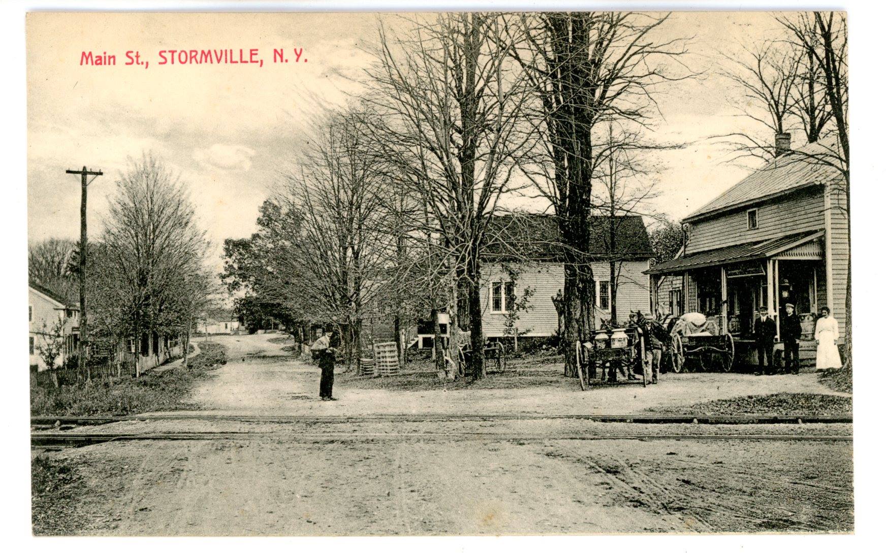
We crossed over Rt 216 at grade, and then reached the settlement of Stormville where we crossed Old Route 52.
This was the former site of the Stormville Station. It was just across the crossing on the right side of the tracks, and passenger service continued here as well until the 1930s.
The settlement is named for the Storm family who farmed the area for three generations.
Stormville marked the only spot on the entire hike where there would be the opportunity to get any food or drink. It was a bit of a side trip, to the left on Old 52, and to the intersection with 216 where there is a Shell station and a mini mart.
There were directional signs pointing out some sort of art show that had arrows drawn all over it to confuse people.
Somewhere in town there used to be a regular general store, which it seems must be now either completely altered or demolished because we saw no sign of the building. There were some thirty structures at one time in Stormville, but now it looks like many of them are modern.
We went to the mini mart for food and snacks, and there was a pizza place across the street, but I don't remember if anyone went over to it, or even if it was open at all. We then made our way back to the railroad bed at the former station site.
I had to convince Eric to get himself a beer on this stretch. New York sells them everywhere, and no one is going to bother him, but he was leary about it. I was glad he finally went for it.
We continued across Seaman Road on a bridge, and then through more woods. We crossed some sort of police area access road at grade, and then a farm access, and then we passed by the Green Haven prison on the left.
We crossed Green Haven Road ahead to the east of there, and in the next wooded section below Stormville Mountain, we passed a lovely cascade on what must have been the Frog Hollow Brook.
The entire route was overall just relaxing. The tracks were to our right after switching again, and there were interesting rock formations on the mountain to the right. We passed a farm underpass and views over fields with mowed paths to the north,
The section was also a steady downward slope, so it was really relaxing to follow.
I walked and sang and chatted with Serious Sean a lot about music and beers we'd liked. I had procured an interesting Russian Imperial Stout for this one called Break Dancing with the Czars, which was really pretty great.
Then we got silly and Sean said I should put a photo of some kale up on my Metrotrails page like I do with all of the beer samples we had liked, and of course I went for it.
Pretty soon we came to Depot Hill Road, which was another former station stop on the old railroad. I set up a then and now compilation using a historic 1950 photo from the Kent Cochrane/Thomas J. Macnamara Collection at the site. The locale is also known as Poughquag, and I guess the station from time to time might have been known as one or the other.
The railroad shifted to the north and went around a very dramatic bend back to the south where I set up another compilation photo with a Roger Liller collection photo.
The Depot Hill Rock Cut at this corner was very dramatic and amazing, originally blasted out by the New York and New England Railroad in 1881. The New Haven line widened it to double track width in 1905. There used to be a watchman's shanty there at the south side of the cut to keep an eye out for fallen rock on the tracks.
We crossed Bard Road and continued to the south, and near where the Whaley Lake Stream flows beneath the tracks, the Appalachian Trail crosses over the line. I had of course been to this spot before when I did my series on the AT in New York. I kind of never imagined I'd get around to walking this line at that time though.
We crossed Rt 262 and then skirted a big swamp land to the right. Another big swamp land was also on the right after we crossed the Whaley Lake tributary again, and in another swath of woods I spotted what might have been an earlier alignment of the Maybrook line parallel with us.
Diane and Robin cut out at this point. They could normally have made it in other circumstances, but Diane had had an accident on her bicycle that ended up breaking bones in her face and she was a bit of a mess. She wasn't away from us for very long recovering, but just to be on the safe side, due to some dizziness she had been having, she opted to make the hike for her just a little bit shorter, and Robin agreed to help her do this. We spotted her car at this early out place on the way up.
Pretty soon, we came out to Whaley Lake on the right. This beautiful section of the railroad afforded us unobscured views of the lake, and even went onto a causeway on the lake briefly.
The 2.5 mile lake is the largest body of water in Dutchess County. It is said to be named for a squatter named Timothy Whaley, or for descendents of Lord Wyamarus Whaley, companion to William the Conqueror at the Battle of Hastings who settled here in the 1700s.
The lake was dammed in the early 1800s by the Matteawan Manufacturing Company to provide a constant abundance of water for the textile mills down the Fishkill Creek in Beacon New York, where we had walked when we did the previous Beacon Line hike.
Whaley Lake also became a destination with the arrival of the railroad. New York City sanitation workers had a camp for their use along the lake at one time, and yet another one made use of old pullman rail cars as cabins. It became a rail fan destination in the 1940s when the New Haven line transitioned from steam to diesel engines, and I set up a then and now using an historic 1940s photo from the Thomas J. Macnamara collection.
It was certainly chillier than it had been previous weeks for this hike, but this couldn't keep me from getting in and enjoying this amazing lake. I took a dip at a particularly inviting looking spot while the others walked far ahead of me.
We got past the southern end of Whaley Lake and passed beneath Rt 292 again, where there were abutments for that bridge's predecessor just to the north. Somewhere along the lake was the former Whaley Lake Station, but I did not notice the site of where it would have been.
We passed along more wetlands to the right, and somewhere there used to be a station called Reynoldsville that I understand was between Whaley Lake and Holmes, but I didn't see where a stop would have been. Maybe at the only grade crossing we had between this point and Holmes, on Beaver Brook Road.
I ended up way behind everyone else in the group except for Eric, who I caught up to.
The two of us continued on the rest of the way, and the entire remainder of the group had already reached the side trail in Holmes that went up to the left to the parking lot.
When we got there, Eric went up, but I went to check out the dam on the little lake adjacent to the railroad, and to set up one final then and now compilation. I had found another photo of the crossing at Holmes, and at first I couldn't figure out how it was oriented. I then realized some of the buildings were now gone.
It is rather shocking to see that of all of the buildings that were in close proximity to the tracks, only one of them was visible from the historic photograph today.
I had a few more photos of the area I had wanted to get more compilations of, but that would require walking up the hill further in the other direction and taking more time while the others were waiting.
I headed back across the tracks and up the side trail to reach the parking area and to finish the hike.
Those of us remaining headed back to Hopewell Junction where we got together for dinner I think at Daddy-O's, which the trail signs encourage patronizing because they helped to make the parking and such a reality.
It was pretty good as I recall.
With the completion of this hike, I had only one more hike to do in order to finish where we left off in Brewster to Holmes, and because it was less distance, I planned on that one being partially Highlands Trail, and partially Maybrook Line.
Aside from that one to Brewster, there are about eleven miles east from there on the Maybrook Line to reach Danbury Connecticut, and two full day hikes on the Maybrook Line from Ohioville west of the Hudson down to Maybrook. It was fast becoming a reality that we would actually finish hiking this historic line. I hope to do a big series loop between Connecticut and New York with trails and historic routes there, but which to do first is the next decision I need to make.


No comments:
Post a Comment