

Hike #1445: 10/10/21 Lincroft to Keyport with Jack Lowry, Sarah Jones, Professor John DiFiore, Jennifer Tull, Stephen Argentina, Tina Chen, Serious Sean Dougherty, and Elaine ?
This was another oddball hike I came up with, and a variation of one I had done around 2013 through the same area. Even then, I knew there was potential to do almost the same hike with all different stuff.

I chose Keyport NJ as the meeting and end point. I hadn't hiked to there in many years, and Keyport Waterfront Park is quite pretty. We met there and then shuttled with as few cars as possible to the start point to the south in Lincroft.
I had looked at the trail systems, which almost but don't quite connect, and other open spaces I thought might work well with what we were doing.
My meeting point was a parking lot right next to the old Lincroft Tavern, which got demolished. The tavern was built in 1697 reportedly, and had additions put on up to twenty times. Still, the place was demolished, and in its place was being built a new but old looking building.

I would have much rather they had built something that included at least a piece of the original structure. It's pretty sad that we can't have something like that. It's more than nostalgia.
I went into a liquor store that was in the little plaza and got a Cape May brewery thing called "Boughs of Barley" Belgian Style Quadrupel Ale. I love those styles, but the problem with this one was that it was aged in orange liqueur barrels. I saw barrel aged and didn't realize that it would be far different than the whiskey barrel aged good stuff I'm used to. I popped it open soon after we got started walking and let everyone sample it starting with John.

It was drinkable, but not something I would ever buy again. It was just weird.
The Lincroft Village Green was directly across the street from the lot where we parked. We headed across into that and onto the trails in there. A path took us across Phalanx Road, and then there was an elementary school straight ahead.
From the end of the ball field at the southwest side, I figured we could just cut into the woods and make our way over toward the Brookdale Community College property. I think somehow we established that this was the running meet where I'd met Jenny over twenty years before. I originally thought it was Monmouth University, but it was actually here.
There was a bit of bushwhacking I didn't particularly like on the south side of fields that I thought for sure would go through with some sort of informal path, but there was nothing.

When I was little, everywhere we went there were little social paths because people were always trying to shortcut through woods to get anywhere. Now we find next to nothing. It's pretty disappointing.

We came out to the campus drive somewhere around Lot 4, and then headed directly through a middle courtyard section that was pretty nice. I think we must have gone by the admissions and registration building out to the far side of the complex, and then hit sidewalks. There, there was a long section of boardwalk trail going off into the woods. I wasn't expecting this, so of course we followed it. It led us out to another paved trail where we could go left or right.
I had nothing on google maps at the time (it has since been added), so we went left.

This took us back out to the campus near where we went in, so we had to double back and go the other way. We met a guy working out that way, I guess maintenance or something, I don't remember, who told us we could walk around the outside of the property to the north and that there was a bit of a path. I had my hopes up a little too high based on this info, because we didn't find much of a good path compared to the boardwalk and such.
We turned to the left and came out to an open field where there was a driving academy thing going on.

I think they were doing trainings for riding motorcycles while we were walking by. We didn't want to go too close to them, but we went round much of the lot, and on the noth side, there was a bit of a mowed trail that went through a line of trees along a finger of the Swimming River Reservoir. Once again, one would think that with such a large body of water, there would be some sort of nice foot paths for fishermen or walkers, or at least college kids partying, but we found none of that here.

We skirted Museum Drive heading back to the east a bit, and I tried bushwhacking into what appeared to be a utility right of way, which probably went all the way through to Thompson Park, but it got weedy and I decided we wouldn't try to push through it.

When we reached almost back out to Campus Drive, we were able to cut through to the left in an opening and get on one of the trails into Thompson Park.
This entire area, Brookdale Community College, Thompson Park, and some surrounding lands, were once a thoroughbred race horse breeding and training farm facility known as Brookdale Farm. The park is named for Geraldine Livingston Thompson, who's estate donated the initial 215 acres of land. It has since grown to 667 acres.
Mrs. Thompson asserted that "children have to feel the ground beneath them and go out into the woods and see the trees and birds."

The 1896 Colonial Revival mansion of the Thompson family had been used as a visitor center, but burned down in 2006. A new mansion, pretty much an exact copy of the original, was built in it's place. I'm getting the feeling this is sort of a Lincroft theme.
I think the spot where we accessed the park was known as Preston Grove. We emerged from a path into some mowed fields and then a paved trail, the Thompson Loop that goes all around the property.

We were only on this briefly, and then went into the woods to the left I think on the Woodland Trail. We meandered through the woods on this and eventually came to the Reservoir Loop, which we would follow for quite a while ahead.
We passed by some nice big trees, and along some very pleasant foot paths until we came to a spot close to the Swimming River Reservoir. There was a spot that went right down to the water where there were some steep slopes and some amazing exposed tree roots to climb around on.

The Swimming River Reservoir, which dams the river of the same name as well as several tributaries where they all come together, is actually not a Water Bond Act reservoir or anything at all new.

The reservoir was completed in 1901 by the Tintern Water Company to provide fresh water to the surrounding communities, which include Lincroft, but also Colt's Neck and Holmdel.
We followed along the shore to the west, and then came to a little peninsula at the mouth of one of the inlets, where there was a steep edge and a sandy shore.
It was drizzling out, with just barely a spritz that made it feel slightly cooler, but still very warm. If we had been there on a busy day, we wouldn't have had as good a time, but we got to take a swim at this corner.

I think I might have been the only one to go in at this point; John usually goes in with me, but maybe he didn't this time, I can't quite remember for sure.

We eventually started to continue along the Reservoir Loop, which followed up the inlet to the north. It had some sections of closed trail that went closer to the shore, which we opted to use rather than the farther back one, and we passed by some really awesome huge trees.
It started getting ridiculous how many giant trees there were on this stretch. It was quite beautiful.
Serious Sean and I were having a great talk about music and inspiration through this entire fairy tale stretch of giant trees and such. We brought up different artists, who was overrated, who was underrated, and what Sly Stone has been up to.

I think Stephen met up with us on the trail just ahead of this point somewhere. The trail took us from deep woods onto a somewhat overgrown field edge, then we came out to a parking area at Marlu Lake where there is a little boat launching area.
The paved trail comes across in this area, over the dam of Marlu Lake. We turned left there and crossed it, then left again to continue down the other side of the inlet we had walked up.
We didn't see a trail go in where it was supposed to be at first, so we walked south just a bit skirting open field areas, and then cut in to the left when we found good foot path leading back into the woods.

This was a long ways down along the waterfront again, just like on the other side, but so incredibly peaceful. I sometimes wonder how my hikes have missed so many incredible spots over the years.

We were treated to some great views over the Swimming River Reservoir again, and reached the south side of the peninsula. We then headed west along the shore for a while, and uphill to reach some open field area in what used to be the Marlu Farm. There was a barn on the right of the field edges, and then we reached the old entrance road that was lined beautifully with trees. The beautiful white house on the hill to the right was in view, but we didn't go over to it at this time. It had started to rain a little while earlier, so we were wearing ponchos and carrying umbrellas. Despite the sloppiness of it, we were all still having a pretty good time.

The trail from that point headed directly to the north, and weaved oddly back and forth through the middle of a very big field.

We went straight into the woods at the end of the field, and soon reached the paved Thompson Park Loop Trail. We turned left on this toward Longbridge Road, then right again to the north for a short bit, until the trail came very close to Longbridge Road. We then cut to the left and crossed.
Directly across was the historic Smock Family Cemetery, also known as the Schank Cemetery. It is immediatly on the south side of the Cross Farm Park, which is on the opposite side of Longbridge Road from Thompson Park, and the next bit of my plan for the hike.

The cemetery was used from 1786 to 1890. It looked to be well cared for and mowed off thankfully.

We continued to the north from here at an angle up to a baseball field where there was a dugout. There was a good roof over it, so we all took a long break from the rain and waited under it. Some of the group discussed cutting out early because it was such miserable weather, but I figured it was going to get better soon, and I actually wasn't miserable.
From the back of the dugout, there was a system of paved trails that went through the Cross Farm Park that would be the next bit of this hike. We exited and started following that to the north for a bit.

We weaved around on the circuitous pathways and headed to the north in a sort of indirect route at first. We then hit the trail on the other side of a parking lot that went up to Old Mill Road.

The trail ended right near the intersection with Newman Springs Road, and we turned directly to the right, then crossed Newman Springs immediately. On the north side of the road, there were open fields of the Village Elementary School of Holmdel Township. We went directly into the south side of those fields, and then turned left along a line of trees parallel with Newman Springs Road.
At the end of the lawn area, we turned right, and then there was a fenced off garden thing or something, and we skirted between that and a private yard to come out behind a very old white building, the home of Holmdel Township Historical Society.

The building was formerly the Dr. Cook Medical office built in 1823. We walked from the building across Holmdel-Middletown Road, turned right, and then the Ramanessin Greenway started there.

This section which I believe is township owned connects directly into Holmdel Park, a large Monmouth County park acquired in the 1960s.

I had hiked this section before several years prior, and of all of us on that hike, only Jack was there with me when we did it that time.
The trail follows rather closely to the Ramanessin Brook for which the greenway is named, but google maps and other sources refer to this as Hop Brook for reference.
We continued north on the trail, which was quite nice but at times was growing in a bit. There were a few fallen trees we had to get over, but nothing terrible. I figure because it's part of a longer greenway section, they just kind of let it go, unlike the loop ones that get more heavily used.

As we weaved along near the brook, I went over to stand in it briefly. Stephen had some sort of super special shoes or something, so he decided to walk directly in it.

I told him the trail should be following the creek directly for a long while, so he opted to stay in it for a bit. Although we had some weedy stuff to contend with briefly, it really wasn't at all bad.
While we were walking Stephen hollered out in regret of having chosen the stream as his route. Apparently the water, although shallow in most places, got quite deep in other areas and he wasn't so happy about it. He ended up making his way up at some point, and I think we waited at a little bridge.

There is another little park called Bayonet Park to the east that I hope to explore one of these days, because it too has lots of trails in it, but the connecting areas have some trails that I didn't know existed until we did this hike.
We passed through one field section before the trail switched from the east to the west side of the brook.
We then reached the edge of a field, and Steeplechase Trail went to the left around its outside. We continued on Ramanessin Trail along the right side of the field.

As we walked this field section, I was surprised to see a Monmouth County truck going by driving it to the left. It must have been a ranger or something.

Actually, my understanding is that all maintenance workers in Monmouth County Parks double as rangers. There was a guy that worked for Hunterdon County Parks that switched to Monmouth and came back to Hunteron flashing his badge around to his former coworkers I recall. I'm not sure if they still do that, but it could very well be the case.
We continued through the field to the north side, and then the trail re-entered the woods heading north.

The trail continued for a long way through these woods, on a shelf slope for a while, first heading north, and then to the west. I was impressed that even at field edges, the trail sometimes made its way off and back into the preferable woods closer to the creek.

We came out two field sections heading to the west, and then to the parking lot. We continued to the right because the trail went down from that point to Roberts Road.
I was hoping to cut into the David C. Shaw Arboretum, but there wasn't a way of doing it from the south side at this time. Instead, we went up Roberts Road parallel with it briefly, and then turned left to skirt the north fence of the arboretum.
Heading west, we came upon a very nice cultivated cherry tree drooping its fruit over the edge of the arboretum fence and to our reach, and they were quite good.

We came out to the Pond Walk Trail and continued walking the trail along the south side of Lower Pond. Directly across the pond was the historic Longstreet Farm, which I really do want to tour, but we didn't do it this time because everything was still closed mostly because of covid craziness.

We crossed the land bridge between Lower Pond and Upper Pond, which is much smaller than previous, and then reached the paved trail that continues through Holmdel Park to the north. There were lots more beautiful giant trees, beautifully manicured landscape around the ponds, and large grassy fields for sports and all sorts of activities.
We continued from the pond area through the open fields to the north, which had paved trail on both the east and west side of it, north to the Forest Edge Picnic Area.

There were quite a few people around this area, and I think there was some sort of event going on off to the right of where we were. Another county ranger truck went by us in this area.
I didn't want to be bothered by anyone, so we made our way across the paved road that goes to the Hilltop picnic area, and into a field. The map does not show any trail in this field, but it was obvious that we could continue to the left, north, across and into the woods on the Ridge Walk Trail.
We followed through with this, and it was a perfect spot to go. It followed higher elevation bits of the land through some deep woods that were pretty nice. After an intersection, we turned right.

The trail then descended a bit more through woods and into more wet areas with little tributary springs flowing around.
We went down some steps and over a little bridge, and then the Holmdel Park Activity Center was just to the east.
We cut away from the main Ridge Walk Trail, and took a side trip to the parking area for the Activity Center. We didn't go up to it, but rather continued out to Longstreet Road where we turned left, to the north. The road was lined with invasive Burning Bush, or Euonymous alatus. The vibrant colors near the signs sent poetic rhymes through my mind, stop, go slow and grow, with the matching colors on the plant.

We continued to the north along the road along the road across the Ramanessin Brook yet again, and then turned left immediately on the other side into a field.

There was a mowed trail around the outside of it. It was part of Holmdel Park, but not included on the trail map because it doesn't really go anywhere, but it worked for our purposes.

The mowed trail came out on Crawford's Corner Road. Directly across was the Holmdel High School, so we just walked across and into those fields to head north. We skirted the west side of that property, past an apparent maintenance area, and then around some ball fields to the north side where there was a slope. We went up that on the grass, and then reached one of the on ramps to the Garden State Parkway.

We dashed across this to the left to the NJ State Police Troop D Holmdel Barracks. We didn't go right through the lot I don't think, but rather slightly to the left through the grass out to a paved pathway that leads to Garden State Arts Center from a secondary lot on the south side of the Parkway.

I had walked through the Garden State Arts Center property the previous time I did a different version of this hike, but I didn't want to go through the way we did that time, which was through a swim club property. I actually forget what my exact plan was, but this one worked out pretty well anyway.
We headed up and into the park, and there was a concert going on. It turned out it was Slipknot.
I really was never into Slipknot, and we had talked about if it was a good show, we might try to get tickets and go in, but none of us were really interested in that.

Just to be funny, Sean turned on his speaker in his pack connected to his phone, and started blasting various Disco hits as we were walking through the parking lot full of people tailgating.
I'd seen so many shows at this venue, and it brings back lots of memories. My last one there was The Offspring and Sublime with Rome. The Offspring in particular were great. When I went to that show, I was eyeing up what way I would walk the next time I went through there, which led to this.

We headed up near the north side of the venue (which I always will refer to as Garden State Arts Center, not as some bank name), and then got on a maintenance access road going further uphill.
We started bushwhacking off of the back of this place down toward the road.
In retrospect, this was really a very stupid addition to the hike because it was completely unnecessary to do it. There was a perfectly good road with a walkway along it just to the east we could have used, and instead we did this other thing only to end up on the road anyway.

We bushwhacked downhill, which wasn't so easy, and reached the westernmost lot for the arts center. We then walked along the east side of that past more people tailgating.
There was a grassy swath at the far end of the lots, and we started heading up it toward the Holmdel Swim Club. The last time I walked through, we came from uphill on the opposite side of the swim club, but I figured this way would be easier. It was not, in the very least bit, easier. We ended up doing worse bushwhacking than anywhere else in the entire hike.

We tried skirting the chain link fence on the south side of the swim club, which was somewhat clear at first, but then got to be a complete mess. We headed down into the adjacent woods, but that was just weaving around and dodging obstacles and brush. We eventually said "screw it" and bushwhacked south out to the edge of the Garden State Parkway.
It was actually a slope just uphill from the edge of the Parkway itself, so it was easy walking where no one was going to bother us, and actually offered somewhat of a postcard view of the famous highway.

The Parkway is a limited access highway that stretches from Cape May at the southern end of NJ to Montvale near the NY line, and we've used it for countless past hikes. I've actually come to love it.

The 172 mile route constructed between 1946 and 1957 is to this day the busiest highway in America.
Although there are no signs, it is officially designated Rt 444.
Large trucks over 7,000 pounds are barred from use of much of the Parkway, and no trucks above exit 105, making it one of the last great "leisure highways" like the parkways stretching from New York City. Unfortunately, the urbanization makes the northern part more a route of practicality than leisure.

It originally included ten splendid picnic areas on the route, but only one of these remains open today.
Many exits no longer accept cash, and EZ Pass is encouraged. Tokens remained in use later than many highways, with their use discontinued at the start of 2009.
We walked along this slope above the Parkway for just a little bit, and then kept our eyes to the right as the tree line became thinner. Then, we were able to pop through a narrower section of woods and come out on Bailey Lane, the access road that leads to the swimming club we went around.


There is a paved pathway around some of the perimeter of Ackerson Park, but we continued ot the right side heading north, and then cut through trees to the fields of Indian Hill School.

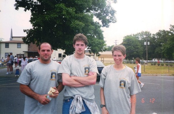
We headed directly to the north from here, and straight on to a playground where we took a little break. It looked like the perfect opportunity for our group shot, so we did it there.

From here, we headed north just a little bit, and there was a sidewalk access from the school lands out to Chestnut Ridge Road where we turned left.
The entire remainder of the hike was just weird stuff that I slapped together as a good walking route, and it felt like the night hikes I'd been missing out on for a while because it was sort of concocted in the same style.
We headed out to the intersection with Bethany Road, turned to the right, and then immediately left onto Hazlet Avenue heading north.

This section of that line had first opened in 1875. It was jointly operated by the Central Railroad of New Jersey and Pennsylvania Railroad.
We turned left into the train station parking area, and then turned right into the activity fields along the north side of the tracks. We headed to the north side of the ball fields, and then used a cut through path to a couple more baseball fields which we skirted on the left.

Following this route led us out to Van Mater Terrace where we turned left. Van Mater got pretty narrow at one point, and then we turned right and I think followed Park Ave north.

I hadn't planned perfectly well on this next bit because I didn't realize that Rt 35 had a median. I was planning on hitting it a little earlier, but there was no way without jumping over, so we went out to Holmdel Road to the west a bit further.
I think I ran into the Exxon or whatever gas station on the corner and got a drink and snack, and then we all carefully crossed over 35 at Holmdel Road, which had to be done kind of quick because there was no formal crosswalk at all. We just had no other way to get over. It's a pretty bad spot, and one would think they'd need to have something there.

Directly on the other side, we entered a cemetery, Shoreland Memorial Gardens. This first one might have been just a public park, but behind it was a regular cemetery.

This was only the first of two of them. We walked north, and this first cemetery bordered Green Grove Cemetery.

We meandered through, and the first cemetery seemed to be much newer than the Green Grove one, which also had some very nice old trees growing in it.
The section that was closest Florence Avenue to the west was in pretty bad condition. It did not look like anyone had mowed it all year long, and definitely no one weed whacked around the stones.
We continued to the north and reached Route 36 where we faced the same problem we had with Route 35. There was a median in the middle of it, and at the end of the cemetery, crossing was not looking so good for us.


There were getting to be more older dwellings as we continued to the north into the older part of town. Keyport has been a transportation hub pretty much since the settlement of the area of New Jersey, because of the convenient location along the Raritan Bay, and beyond direct proximity to New York City.


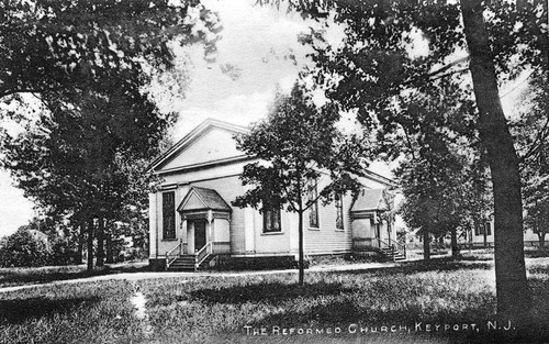
We turned left off of Osborn Street through the yard of the Reformed Church of Keyport.

I had found some historic photos of this old church, and it definitely looked antiquated, but I was not sure it was the same building at the time.
At this point however, I am pretty confident it is the same building. What appears to have happened is the original porch and front two windows are now covered by the modern facade of the building.
There were four windows in the rear which had another doorway entrance, and it seems that entrance was blocked off, the front was added on as a greeting and usher area, but the main body of the building remains the same. It was just slightly altered.


I think I got a burger or something, I can't quite remember, but I remember being quite satisfied with it when we left.
It was dark pretty much by that time, and really a nice time to look out on the bay at the end of the day.
I could do almost another entire version of this hike and have it be mostly different, so I'll have to plan on trying to do that in the nearer future.
The oddball nature of routes like this, with the list of wonderful characters is really the perfect combination.
No comments:
Post a Comment