

Hike #1535; 3/12/23 Cornwall PA Loop with Kirk Rohn, Professor John DiFiore, James Kohan, Mindi ?, Pete Fleszar, and Dan Asnis
This next trip would be the next in my continuing Pennsylvania Highlands Series, which incorporates the Pennsylvania Highlands Trail designated route. I think it was the tenth in the series.

Of course, I'm not doing it the normal way. I'd already hiked the entire Horse-Shoe Trail, on which some of the PA Highlands Trail is superimposed, but there are tons of side trails I'd long wanted to do, so it makes it all worth it to try to get through.
Further, some of the Horse-Shoe Trail had been rerouted since the last time I'd been out there, so I wanted the hikes to include some of those sections. The area was also full of all sorts of old rail rights of way and iron mining sites that were high on my "to do" list.
As such, I put together another exciting loop that would involve a lot of what I wanted to do.


Unfortunately, much of this ended up being far more difficult than I'd anticipated it would be. The mileage would be more like twenty than fifteen, and we'd have the worst bushwhack I'd ever attempted with little Ev in the stroller.

He'd already begun walking, but he wasn't doing well enough that I was going to let him walk on the trails for all that long. They would be rather difficult, and this was probably the coldest start of a day we'd had all Winter. I had to have Ev bundled up pretty good, which meant he was even more uncoordinated.
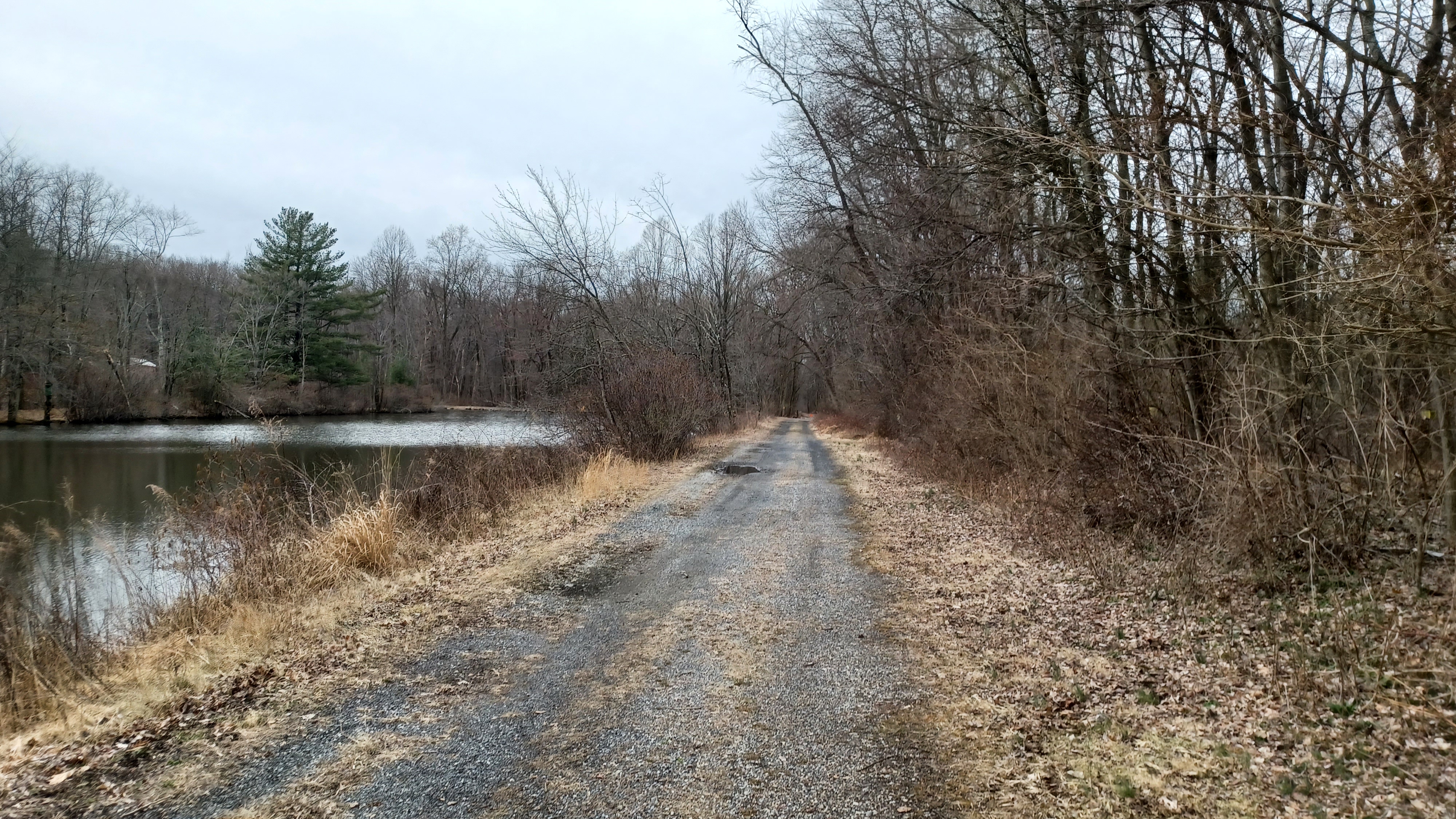
The meeting and starting point was on Schaeffer Road, where the Cornwall Station used to stand on the Cornwall and Lebanon Railroad, which we'd followed extensively on previous hikes.


We started our walk directly from the former station site to head westbound. The C&L goes more southbound from Lebanon, and shifts at Cornwall to go to the west.
Directly parallel with the C&L to the west of us at the station was the earlier Cornwall Railroad, the great competitor. It crossed over the C&L at a point just barely below the C&L's station.


Originally, the crossing here was at grade, but it caused major problems, so it was changed so that the C&L would be raised and then pass over top of the older line by way of a through truss bridge that still stands to this day and carries the trail.


The Lebanon Valley Rail Trail follows the route between Conewago and Lebanon, but the routes to the south from here have not really been developed for recreational purposes. Still, I wanted to try to see what was left of them, and so that is why I planned the hike the way I did.

I had prepared to do a whole lot of then and now photo compilations at the start of this hike. Greg Pawelski has an amazing collection compiled ad he'd already done a lot of them in the area, but there are just so many to do, and through doing them, help us to understand what used to be there.
Right from the start, I was ready to start getting ones of the old station and such. When we started walking, we headed to the west on the old Cornwall and Lebanon line, and there was just a ton of stuff to see.
We crossed over the older Cornwall Railroad on the old metal truss bridge, and then continued to cross the Burd Coleman Road bridge, where there were two more historic photos taken from the higher rail grade I wanted to emulate through then and now.
The old Cornwall Railroad below, as planned, would be our return route.
It was a very pleasant start to the trip, just heading west on the railroad bed. We'd done this segment already before, but it's so nice that it was just fine to repeat the short segment again, because the rest of the hike would be entirely different.

We passed beneath Creek Drive, and then crossed Overlook Drive at grade. The pleasant section of woods had a mountain biking side path along it much of the way, usually below to the left.

We continued walking through nice woods, and parallel with some new developments. We crossed Alden Way and passed trail parking we had used in the past on these hikes, and then passed beneath Rt 322 and 72, Horseshoe Pike.
Once on the other side, we went just a bit further toward the bridge that carries the rail bed over old Rt 72, now known as Mine Road. There is a little side trail down to the left that leads to the road level. We followed that down slightly, and then turned to the left across Rt 117 onto Mine Road.

It was a steep bit to start with, uphill into the Furnace Hills. Partway up, we let Ev out to walk for a bit, and he did really well making his way uphill, mostly in the section where it is closed to traffic.

After a house up on the hill, there is a gate, and the road is abandoned, on the east side of the Clarence Schock Memorial Preserve at Governor Dick (Governor Dick was a slave leader that escaped, and had the hill named in his honor. Clarence Schock was an entrepreneur that opened his property as sort of park land before it was formally preserved. See previous journals for more on these individuals).
Trails broke off to the right into the Governor Dick property, but we remained on the old highway this time. We had to continue on that until where the Horse-Shoe Trail joins from the right.

We had done the previous section of this on our last hike, and this time my plan was to continue on that trail to the east, to where it passes through State Game Lands, and I worked out a route that would involve some more game lands as well as the railroad grades.

I had hiked this section of the HST before while backpacking with Jillane, but that was back in 2011 and for all I knew it could have been all rerouted through the section.
We continued on the old road route after the trail joined, and came back out to Rt 72. The trail continues straight across the street onto Spring Hill Lane, and so this section was quite easy and pleasant.
I think we turned right on Aspen Lane, followed by Ash Lane, and then cut to the right from there at some point in a short distance.

The trail took us down an easy, clear route through trees that led down to the back of a private property. That's one of the things I love so much about trails like the Horse-Shoe Trail; they do so much weird stuff and go places one might not expect.

Once we got to the back of that private property, the trail turned to the left onto an abandoned road grade heading south sort of parallel with the Schearer's Creek. It was a bit bumpy, and Ev was getting pretty tired. It was already getting to be time for his morning nap and he slept through some of this chaos.
We continued on, and then got to a spot where the old road used to cross a bridge over a tributary, but it was washed out. I got assistance to get the stroller across, and we were on our way on the other side.

We crossed a power line clearing with a bit of a view, and continued on the good road grade to the south, which in a short while led us to the edge of a plowed corn field.

We skirted the field briefly to the left, and then continued on another woods road parallel with the fields to the left. The route leads sort of south toward the Pennsylvania Rennaisance Faire.
Before reaching the next field opening, the trail turned to the left into the woods on a footpath, which descended gradually toward the Schearer's Creek. Just before reaching the creek, we noted an old mill race somewhat parallel with it. It must have been a pretty substantial raceway to travel so far above the creek for so long. I wonder what industry it once served.

We crossed Schearer's Creek on a foot bridge, then meandered through more woods. At one point, the trail got to an area that seemed quite flat.

I couldn't help but wonder if maybe this was part of an old logging railroad right of way that operated through this section of the Furnace Hills. I think it might have been, because the Strause Company Logging Railroad operated all through this area. I'm not sure the extent of their operations, but we'd reach some of it later.
Eventually, the trail turned to the left and began ascending more of the Furnace Hills again by way of an old woods road that weaved back and forth, sometimes through a rather deeply eroded cut.

Getting the stroller through wasn't really terrible, but I was wary of the tires going through this. At the time, the front tire was regularly going flat, and I was pushing it along sometimes at too low pressure.

I purchased a super light weight pump from Walmart around this time that I'd use at the start of the hikes, which would usually provide enough air pressure in the tire for the entire hike.
At the top of an ascent, we reached the power line clearing we had crossed a bit earlier. We turned right on the path along this power line. The Horse-Shoe Trail follows the line for a pretty good distance, but it's not too hard to walk.
Somehow, in this past section, when we had first turned away from the fields toward Shearers Creek, Dan continued going straight toward the Ren Faire property and lost us.

I got hold of him on the phone, and he had to backtrack through the farms to find where he lost us. At some point on the power line, we determined where he had lost us and he got back on track.

We continued up and down some slopes on the power line for a bit, until eventually the ground around us started to even out. On this stretch, we came upon the edge of a wye where trains could be turned around from what used to be known as Penryn Park and head back toward Cornwall and Lebanon. We could have cut a corner and turned here, but I wanted to tie up the loose ends on the Horse-Shoe Trail, so we continued on the trail straight ahead.
The trail followed one leg of the wye, as well as the power line, and some of this power line section got really extremely wet. There was no good way around it, and so we muscled on through it. Eventually, the trail turned to the right away from it and into the woods.

We descended for just a bit, and crossed the former Cornwall Railroad, which is partially on or next to Penryn Road. The Horse-Shoe Trail turns right on the road, and then left away from it along the Penryn property, more recently Camp Shand.

There's quite a lot of interesting history associated with this property.


When completed, the Penryn Park grounds included a pavilion, bandstand, fountains, dancing floor, and a 45-foot observatory atop the mountain. A man-made lake for boating fed by the Chickasalunga Creek was also constructed.
 |
| 1911 James W Kerscher Collection |

Passenger service to the site began in 1885, and in 1886, the Cornwall Railroad officially merged with the Cornwall and Mount Hope Railroad, which extended south to the Reading and Columbia Railroad at Manheim. This brought in passengers from Lancaster and areas south. It was built as a separate line in 1884.

 |
| 1911 James W Kerscher Collection |


 |
| Mark Cain collection |


 |
| Mark Cain collection |

We walked down the road, and the railroad bed was immediately adjacent but overgrown to the right.

 |
| L G Harpel 1910 |


 |
| Pereg image |

I didn't want everyone to hang around the pond for too long, although it would have been a good spot to do so. I didn't want to cause any stir about us being back there, even though it seems allowed now.

 |
| Manheim Preservation Foundation image at the pond |
 |
| L C Harpel, 1895 |


After a bit, I noted a stone wall, and what looked like it might have been another railroad grade breaking off to the left into the woods. I assumed that this might have been the Strause Company rail grade that I'd been reading about a bit.
The Strause Company constructed a 36-in narrow gauge track in 1923 from the former Cornwall Railroad near Penryn Park in 1923 into the Furnace Hills to move lumber for shipment. It was at one time the only logging railroad operating in Lancaster County.
The logging line was scrapped in about 1941. Today, only some remnants can be seen of the grade of the once very prominent business.

We continued ahead on the woods road section, which seemed to get even steeper on the down grade, on a fill, then into a cut. I thought to myself that it was going to be quite the climb to get back up.
The walk was very pleasant through this entire section, which eventually led into State Game Lands #156.
I wasn't sure how far the woods road would continue on the railroad bed, but at this point so far, it was way better than I'd anticipated it would be.
Just about where the right of way shifted from heading west to south, the woods road cut off to the left to some sort of private weekend home or hunting camp, and the route became very overgrown in a deeper cut straight ahead. It didn't look too terrible at first, so I continued pushing the stroller through.
 |
| 1929 Strause Lumber Co image |
There were a lot of down logs, so it took a lot of help to get Ev over the things. It kept getting harder.

We pushed ahead, and I noted what might have once been a siding track to the right of us, around the outside of the cut, either that or more of the lumber line. I'm not sure what it was honestly.
The right of way started to straighten out a bit. Trees to the left of us were painted white denoting the State Game Lands boundary. Ahead, there was a lot of Japanese Barberry growing in over the rail bed. it was obvious that this was somewhat passable not so many years ago, but it has gotten really bad. If I didn't have the stroller, we would have been able to push through this segment with very little trouble, but everything is different now.

It got too bad to pass through, so I watched the aerial images and GPS location on my phone to see where we might be able to start pushing uphill into the game lands to reach some of the trails and roads on that property.
 |
| Dillon Bomberger image of the pond at Penryn |
A corner of the state game land woods roads can be seen on Google Maps, and so I was trying to aim for that, but it was really rough going east, uphill with no trail. I was hoping that we'd have some woods without much undergrowth, but this was a mess.

We pushed on, and zigzagged uphill. I could not handle pushing the stroller any further through this bit, and thankfully my friends offered to help take the slack. I picked Ev up from out of the stroller, and Kirk took on the stroller while I pushed ahead further.
I fast got ahead of everyone else, and Ev seemed visibly stressed although he didn't holler or yelp until some bit of vegetation would touch his face.
There was no easy way through; I just made my way through as best I could, and eventually we made our way out to a vegetative clearing along a woods road up the hill.

From there, we just walked through the high grasses to reach the woods road. I put Ev down when we got there and I called out to the others to see where they might have ended up.

Jim showed up first; he used the term "chunk it up" when it came to how we handled the stroller situation. Kirk kept the main frame of the stroller, Jim took Ev's seat, and John picked up my pack and stuff from under it. Kirk ended up well out of the way from where the rest of us got through.
This was the worst part of the entire hike. It was really tiring. I was glad when it was over with. This experience led me to change how I looked at the remainder of the hikes in this series and how we would handle all of the stroller type stuff.

When we all got back together, we continued along the woods road to the east. It went very gradually uphill with some relaxing bits. There was some recent tree clearing in some sections of this which provided for some views to the northwest as we climbed.

It seemed like every time we thought we were at the very top of the Furnace Hills in this area, we just kept going up higher. I found out later that this section of the Furnace Hills sits at above 1,000 feet above sea level, which is a bit odd for a Highlands geological province summit.
We continued along past the clearing from the logging, and I didn't realize it at the time I don't think, but we crossed over and joined briefly one of the old Strause logging railroads. It appeared from the left in an area that was somewhat cleared, turned off to the right, and then another game land road was built over some of it.

We continued up the last ascent, and then had a relaxing bit out until where there was a gate, beyond which the road can be driven.

Right at about this point, where there are some communications towers, we reached the Horse-Shoe Trail. It continues ahead on these game land roads, but we had to head back in the direction we were previously, down the ridge.
At first, I was able to push the stroller along the foot path section, but then it got very rocky and steep. I wasn't going to be able to do it myself again, and Ev was not quite able to handle such rough trail walking yet.
Thankfully, we had figured out how this worked, and everyone helped to get all of mine and Ev's stuff down the north side of the Furnace Hills again. In the future, I'd make sure to have it so it would be less a burden when we got to places like this, so I could put most stuff in a pack.

Most of the trail was probably at one time a woods road, but it had washed out pretty badly over the years to the point that it was very hard to just push a stroller through.

When we got down to a level where it became easier to traverse, there were some stick forts and such, apparently from the YMCA kids that camp in the area. The trail turned to the right on a woods road system, which took us through a bit of an activity area. A lot of random stuff was all secured to wooden boards including pots and pans, sandals, and all sorts of stuff.
We made our way further down and crossed over the creek again. It was much smaller in this area, but there was a good foot bridge there.

Pretty soon, we came back up to Penryn Road and the old railroad bed. We simply turned right and remained on the road, with the railroad bed beside us to the left, and passed where we turned from the Horse-Shoe Trail before. This time, we would continue trying to trace the old Cornwall Railroad back into Cornwall.

We passed by a ball field on the right where supposedly Babe Ruth had played once.
To the left, a double stone box culvert reminded us that the railroad bed was just to the left of us. The gravel road took us uphill slightly and gained the same elevation as the rail bed, which at this point had been quite a bit above us.
We continued on the road out to the power line crossing, the same the Horse-Shoe Trail followed for a time. At the power line crossing, the old railroad bed weaves off to the left for a bit, and then goes through some private land.

We continued on Penryn Road, and the rail bed emerged again near the entrance to someone's driveway. It paralleled the road for a bit more, and then turned away again when the road went right.

The Cornwall Railroad continued north to pass beneath Rt 322, but we had to continue to the right on the Penryn Road past more private homes.
When we reached Rt 322, I headed over to the left to check out the bridge, which is still in place, that carries 322 over the former railroad. Everyone was pretty tired by this point because the mileage went well over what I was planning on doing. I think before the end of the day we ended up hitting 21 miles instead of 16. I thought I had it right because I planned on a route that would be accurate Horse-Shoe Trail miles, and pretty accurately on the railroad bed, but I guess we did a bit more than I had anticipated.
We headed from 322 north onto Boyd Street, which closely parallels the old railroad bed.
 |
| Strause logging rr begins to appear on the left here |
We were all getting really tired, and I started falling behind the group a bit, pushing Ev more comfortably in the stroller by this point.

The railroad bed was below us in a rather deep cut at first, but we descended on the road a bit until it was just along side us to the left. There were some seriously rich people who lived along this stretch of road, one of which had a very imposing gate in front, and had all sorts of anti-pandemic signage out in front of it with just about anything you could imagine to say against the management of it.
Soon, the right of way crossed over Boyd Street and went into property where it was gated with a chain link fence. Even without Ev, I wouldn't have bothered trying to go through that segment.

We continued on the road, which didn't have the greatest shoulder for walking, but we got through it alright. It wasn't terribly busy.

I recall that Iron Valley Road was on the right, and that it was apparent where the tracks used to cross that, but we continued on Boyd until it crossed that too. It was really overgrown at this point, and there was also a second right of way parallel with it at this point, which was associated with the rival Cornwall and Lebanon Railroad. It came in to the north of the Cornwall Railroad track, and there were more tracks that weaved around hillsides for the purpose of extracting iron ore.
I wanted to focus more on the Cornwall Railroad this time, but really neither were well accessible, and we had gone so far on this one that I didn't want to push anyone any further.

Boyd Street turned hard to the right and to the north of the railroad bed anyway, and so we had to continue on that. It was fine by me, because I wanted to walk through the intact historic miner's village.


We continued around another bend, and into the start of the community, which is simply known as "Miner's Village" to this day.


The homes, and the furnace buildings (which are maintained by the Pennsylvania Historical and Museum Commission), retain their historic charm and are well worth the visit.

I held back in the neighborhood as we headed into the older portion of it. The material of the buildings changed from brick to fine cut stone, and some of them had the reddish corner stones known as red quoin. I had a couple of historic photos taken in 1900 and 1910 in the same vicinity, so I held back to try to emulate them.
At this point, only John held back with me while the others pushed pretty quickly ahead.
We made our way out of the town, and the road ascended a bit. There was a big hillside that once had rails to it and mines and such I understand, and the main mine pit started coming into view to the left.

This giant pit was to the left, and I had several historic photos I'd seen through Greg's collection I'd wanted to get through this area. John and I reached the peak of the hill, and there was a small wall from which I noticed some of the land profile looked just right.

It was just by chance I noticed this first one, and because I was watching for such things, I was awake to finding more of those then and now opportunities.
I ended up getting several of them that were taken from around the elevation of Boyd Street. If I come back another time I could get more from the slope across the street, but I wasn't going to try it at this late point in the day, and with Ev in the stroller. I don't like running off and stressing him out.
Some sort of modern industry is using buildings down along the edge of the mostly watered mine pit. The railroad was right there below us and parallel with Boyd Street for a bit, serving those industries.

I thought I could see some of the right of way parallel with the road while looking beyond the chain link fences to the area below. It's amazing to think these areas were mined starting in 1739.

We weaved around a corner and slightly downhill. No one else was in sight anymore, but this was coming into some of the really cool stuff I'd hoped to spend more time looking at.
There was a reason I chose this particular hike on this particular day, besides the fact that it was the next in the PA Highlands series.
I had found out through Diane that the Cornwall Iron Furnace museum was having a free open house day, which occurs once a year, and I figured this would be the best day to have a hike through the site.

Diane comes out on most every hike, but she was going to miss this one because she had pre-made plans to be at the museum open house. I decided that my hike would involve going through the open house, and my plan was that we'd be back to the museum well before it closed at 4 pm or so.

Unfortunately, because of some of the hardships we were facing, it set us behind quite a lot. We missed the closing by probably almost an hour, but we still got to walk through the grounds anyway.
I find it amazing that these ironworks started in 1742, the same year that the Union Ironworks started where I work, and that was only a year after the Oxford Furnace, also very near my home, began operation. To put it in perspective, Oxford Furnace was only the third mined iron furnace in America, and by a year later, they were popping up all over the place.
 |
| George I Slonaker image |

I even understand that William Allen, who was one of the owners of the Union Furnace, was involved in the Cornwall Furnace as well.

We missed Diane by quite a while because we ran so far behind.
As we headed downhill and slightly to the right, the next historic building we came across was a sort of stone mansion house on the right, the former Manager's House.
The ironworks manager was second only to the owner and resided in this house starting in the early to mid 1800s. In the twentieth century, Bethlehem Steel used it as their local office building. Today, it serves as a daycare center.


Directly across the street from the manager's house was a handsome stone building known as The Abbatoir. This was a Gothic Revival style smoke house with quatre-foil windows, built to serve the estate.

We headed across the road from the manager's house, past the Abbatoir, and then to the north a bit more to the old blacksmith shop and wagon shop. These buildings were of great importance to the operations of the ironworks, and are as I understand part of the museum grounds today.
Consequently, it was Margaret Coleman Freeman Buckingham, great granddaughter of Robert H. Coleman, who donated the lands to the Commonwealth of Pennsylvania in 1932.
We turned to the left and began heading slightly downhill to the main furnace complex, and there was a large kiln off to the left, with a sign reading "roasting oven".
 |
| 1972 Robern M Vogel |

This kiln was where the iron ore was "roasted" to eliminate sulfur impurities before it moved on to the smelting process.

It is believed that this building was probably built in the early 1800s when the local mines began yielding lower grade ore making this process more important.
The views of the main furnace were really amazing as we got closer. The entire place was not what one would expect of a colonial iron furnace, because the original furnace is almost completely encased in a newer building. The 1742 iron furnace only revealed itself at the top of the stack around a Gothic Revival style outer area with sharp, church-like windows, constructed under the Coleman dynasty leadership.
 |
| 1983 Lebenon Co Historical Society |

The fact that the place is preserved so well makes it the finest example of early American charcoal fired ironworks in existence.

John and I meandered through the site and had a much closer look around as best we could without going inside.
We passed through the property and came out below on Rexmont Road, where I was able to set up a couple more then and now history compilations.
At the ninety degree bend in the road below the furnace, I set up the few shots, and then we reached where the Cornwall Railroad came out along it again, from an industrial site to the left.
 |
| 1922 Cornwall Railroad Historical Society |

I had more photos I'd have liked to get in this area, but again it was getting too late, and we'd already lost almost everyone else. John said Kirk had been close by, but then he disappeared somewhere.

As we walked ahead a bit, Kirk would soon emerge behind us, having made his way off into the woods to answer the call of nature.
We continued along Rexmont Road for a short bit, and then there was a trail going off to the right. This was the former Cornwall Railroad, and it was a trail associated with the Cornwall Manor development.
We followed the trail for a bit to the north from here, which was nice and clear, but it seemed to shift to the right. This meant it was either the original alignment of the Cornwall Railroad, or the Cornwall and Lebanon spur.


We didn't want to be heading into the development area, plus it was signed, so we headed out to the edge of Rexmont Road where it was obvious the railroad bed was on a fill to our left.

As we were heading off of the rail trail segment at the development, Kirk showed up behind us. I got a call from Jim checking that we were making it back okay, as the rest of the group had gotten back to the cars.
I felt bad that our newcomer, Mindi, was not having such a good time of the hike because it was longer than anything she had ever done before, and went well over what I was planning on doing. The difficult nature of some of it was atypical of what happens with the group, and so she didn't get a totally accurate idea of what our hikes were like.
 |
| 1860-1870 Cornwall Furnace, National Park Service Collection |

Kirk and I agreed that if Jenny had been with us (she's out backpacking the Appalachian Trail), that she might have enjoyed it more, because she'd have presented it in a better light.

Pretty soon, we crossed where a bridge used to be on the railroad, near the edge of Burd Coleman Road intersection. I had a closer look at some of that for some more then and now history compilations.
Ahead and across the Rexmont Road intersection, the Cornwall Railroad continues overgrown and the other spur heads off to the right into the development. The Cornwall Railroad bed was completely overgrown and pretty much inaccessible ahead. We could see ahead to the through truss bridge that carries the Cornwall and Lebanon line over the Cornwall Railroad, through the trees.
 |
| 1933 Hagley Museum archives |

I wanted to try to walk this, and it might be a bit clearer ahead, but it was not really possible from where I was standing.
 |
| 1950 Lebanon County Historical Society |

Just ahead, the historic Cornwall Mill, built in 1798, used to stand to the right. It was demolished in 1960.
 |
| Burd Coleman underpass, Lebanon County Historical Society |

We continued up Burd Coleman Road from here and passed beneath a handsome stone arch culvert beneath the Cornwall and Lebanon Railroad, for which I had a couple of historic photos to emulate. It was a narrow culvert, but not a lot of traffic and pretty good line of sight.
 |
| Pre 1900 with Cornwall Mill |

Kirk fell behind again I think somewhere in this area, and I think I missed pointing out that we were walking over Snitz Creek, which we had crossed where it hits the Susquehanna on a previous hike.


He found it hilarious that other time, and so this time I think I ended up neglecting to tell him we were crossing it yet again.
 |
| 1930s photo by Luther G Harpel |

We exited the culvert, crossed the stream, and then turned hard right where Burd Coleman Road turned. There were some nice views of the culvert from that vantage point.

Pretty soon, we turned to the right over toward the Cornwall Railroad bed again, which is now a parking area for the Cornwall Inn, which occupies the historic Cornwall Store building.
The store apparently dates to the mid 1800s, and now serves as a private inn. I had a few historic photos of the building I wanted to use to make then and now compilations, so I set those up.
The rail bed from this area heading a bit to the east is now a parking lot that serves at first the inn, and then beyond the municipal building and police station.
 |
| Lancaster Magazine Collection |

The building itself is the historic former Cornwall Station for the railroad. To look at it today, it really looks nothing like a train station at all. No one would ever guess.
 |
| Minersville/Cornwall collection of Cornwall Store |

The building does still have the high peaked roofs similar to what it had when it was the train station, but it otherwise looks like a much more modern design.
 |
| Cornwall Station Lebanon County Historical Society |

The station underwent a major renovation around 1950 which majorly changed the facade of the building, but kept on the same basic shape, so I was able to set up several more compilations.
 |
| Railraod Museum of Pennsylvania |

I ran around the front of the building, then around the back of it while John and Kirk stood with Ev and the stroller. I tried to get in every position to get every historic view I could.
 |
| Timothy McFeely Collection |

There were even some of them I had missed from earlier in the day, taken from up on the slope above on the Cornwall and Lebanon line that I neglected to get while we were up there.
 |
| Mark Cain collection |

I ran up some faint side paths to get to the other grade from below in order to get these last couple of images I needed.
 |
| 1950 James W Kercher |


We reached the intersection with Boyd Street and Freeman Drive, and turned to the right. I managed to get just a couple more shots looking from the former road crossing on the Cornwall Railroad before heading back toward the parking lot.
The right of way is taken over by some yards straight ahead, but I was able to step down and get at least a couple of views.
We continued to the crossing of the Lebanon Valley Rail Trail on the C&L line, and there's an old stone building on the right that looks like a stone railroad station style, but it is not one. The architectural style is found in many of the buildings around the area.
 |
| 1950s E Scott |

We turned to the parking lot, and said our goodbyes, and Kirk and I headed back in the car in the direction we had just walked from so I could get some better photos to match the historic ones before heading home.
 |
| 1911 James Kercher |

I did pretty well and got a huge mess of the compilations I'm very happy about. It took a little extra time at the end, but it took the sting out of some of that extra mileage we had done.
 |
| 1952 Railroad Museum of Pennsylvania Collection |

We were really tired and soon stopped by Sheetz to get some kind of food for the way home. Amazingly, I was really good to drive. I didn't feel myself falling asleep at all, which is always a concern when I have a long drive ahead.
 |
| Lebanon Historical Society |

This one forced me to do a lot of thinking about how I was going to manage some of the hikes going ahead. Some of the terrain might be tough.

Even though the Horse-Shoe Trail segment was far easier than the bushwhack mess, it still required help from my friends to get the stroller and all of the stuff through. I can't remember all of the details of previous sections of that trail, and so some might be tough with the stroller.
I would have to plan some of the next ones accordingly, so that there was enough easy stuff to go along with the potentially difficult sections. We could handle a bit of difficult terrain breaking it up in the way that we have, but I don't want to go into it too badly like we did in the mid section of this hike.
 |
| Lebanon Valley Historical Society |
.jpg)
I figured this could work out really very well; as Ev is getting older and walking more independently, it could all coincide with the continued addition of harder trails that fit his ability levels. If for some reason he is slow to progress in that way, I can adjust plans accordingly.
This would end up being one of the toughest hikes of the year (maybe it'll be the toughest), but it was also a learning experience that would be of value to us.
No comments:
Post a Comment