Hike #1531; 2/19/23 Horsham and Warrington Area Loop with Diane Reider, Koshek Swaminathan, Professor John DiFiore, Heshi, Luke Freselone, James DeLotto, Justin Gurbisz, Shane Blische, Jennifer Berndt, David Goldberg, David Adams, Laura Nycum, ?, Violet Chen, Serious Sean Dougherty, and EverenThis next hike would be a very interesting loop trip through Montgomery and Bucks County, fitting into the Neshaminy Creek watershed area once again.
It seems like we've almost completely done the Neshaminy watershed, but there is always something more. Especially after I have a hike in the area, I see connections, both in person or on the maps, and I realize there is so much more to see.
This was such a case, where we'd end up finding so much more stuff to explore, and connections to be made with other area series.
I made the meeting point for this one the Regal Cinemas of Warrington just north of County Line Road. I was glad we didn't have any snow on the ground, because that would certainly have made the going a bit tougher.
Once everyone was together at the lot, we started our walk by heading to the south slightly.
This location touched where we had been on a previous Neshaminy series hike just to the northwest, where we had followed a trail and grass along a development. The start of this hike, as well as the first several miles would be completely disconnected from everything we'd done before. We'd eventually connect with where we'd been on previous hikes when we got close to the Rt 202 Parkway Trail.
This was the first time in a long while I'd seen Laura Nykum; she usually doesn't come out during any warm weather, and things had been so crazy the past couple of years that she wasn't able to make it out. She got along with little Ev immediately. She handed him sticks and such, and would reach over the side of the stroller to smack whoever was walking by. Laura would jump back and act scared whenever he did it, and he'd laugh hysterically.
We walked through the back of the Cold Stone Creamery lot, and then out to County Line Road. The tires on my stroller have been giving me some trouble going flat too quickly, but I managed to fill them up in the morning at Quick Chek before heading out.
We followed County Line Road to the west for just a bit, and then on the south side of the road there was an entrance road into Graeme Park. I'd been wanting to explore this place for a while, ever since a past hike took us by the site and we talked about how more of the land was now a park.
The long lane was nice with large Sycamores lining the sides. It leads to two historic farmsteads across from one another, which are kept in beautiful condition.
The historic Keith House at Graeme Park is the only surviving residence of a colonial Pennsylvania governor, at this point in Horsham Pa (the county line is rather obviously on the road of the same name, and we crossed from Bucks County into Montgomery).
The estate was known as Fountain Low when the stone Georgian style mansion was constructed by Sir William Keith about 1722. It was a country getaway from his Governor's Mansion in Philadelphia.
Dr Thomas Graeme acquired the 1,700-acre Fountain Low in 1739 and renamed it Graeme Park. Graeme was husband of Ann Diggs, Sir Keith's stepdaughter.
Graeme served
on provincial Council and Supreme Court of Pennsylvania, as well as several other physician titles. They use the site as a country residence initially, but it became more a full-time residence in 1765.
Graeme died while walking the property in 1772, and the property went to his daughter Elizabeth and her husband Henry Hugh Ferguson.
The property was confiscated during the American Revolution in 1778 by the Continental Congress due to Ferguson's loyalist sympathies.
Elizabeth later regained the property and lived out most of her years there.
Samuel Penrose purchased the property in 1801, and constructed the second farmhouse in 1810, which sits across the road and just to the south of the Keith House.
The Penrose family began the tradition of posting tours for school groups and historical societies here.
The tradition continued with the Penrose family until 1920, when the property was purchased by Welsh Strawbridge. The Strawbridge family continued the tradition started by the Penrose family in 1958, when they donated the Keith house and surrounding area to the Pennsylvania historic and Museum Commission.
The house to the south is thus referred to as the Penrose-Strawbridge House, but the grounds around it appear not to be open to the public. It seems a caretaker or something is living in that house. I had some historic photos of it I wanted to use for comparisons, but unfortunately, we wouldn't be able to get those this time.
There was a lovely creek and a small mill dam in front of the place. To the left of the Keith House was a pretty little stone Summer Kitchen.
The original building here was constructed in 1755, but at some point demolished. The current structure there was built on the exact same spot as the original in 1969.
We walked around to the back of the Keith House, and there was a pleasant, mowed path that went off into the woods for a bit, so we decided to follow that from the start.
The path weaved us into the woods, and then emerged once more a little to the west, further over in the yard. We then headed toward the barn building on the property, which had a sort of party tent going up on the side of it. Apparently the site hosts some events.
We continued around the barn, which afforded us some nice views of both the Keith House and the Penrose-Strawbridge House ahead.
Once around, I got a couple more photos of the Keith House for my then and now presentations, and then we moved down the gravel roadway to the west.
We soon reached another road that went in a more north/south orientation, known as Governor Road. We turned left on that and followed it away from the main farm area to a spot that looked like it was more actively cultivated.
The Google maps showed this site known as Strawbridge Park, but there were no signs or trail markers showing any way through it.
We opted to continue straight on the road, because Google maps seemed to show that there might be a way through.
We came to a chain link fence, which barred us from getting too close to the Horsham Air Guard Station. I for some reason thought this was defunct from driving by before, and that we could get through. Such was not the case.
We tried going to the right through fields, because I still thought maybe we might find a way through, but no such luck.
We continued to the west, reached a ninety degree bend in the fields and adjacent fences, and head to walk to the north. Pushing Ev through the stubs of cut off corn was not fun or easy.
We managed to reach the north side of the field, and I was hoping to find some sort of way through to the north and out to the next road, or better yet, a trail, but we came across nothing.
We had to continued back to the east along the north side of the field, through a swath of trees, and had to lift the stroller over a mess of fallen branches. Eventually, we were able to get through to where we were at first, at the end of the fields on the farm access lane. Dave stayed up front with me to help lift Ev in his stroller over some of the many fallen branches.
It was a relief to be back out to the gravel road again, but it took us a lot of time to do this rather pointless loop.
We followed the Governor Road to the north out to the Keith Valley Road. Once there, we turned left to follow the road west for a bit.
Much of Keith Valley Road was really crappy. We walked on the left facing traffic, but the Park Creek was on the other side pretty close to the road.
We passed some businesses on the left which provided us with a bit more room to walk, but at times, it was necessary to come out to the pavement, and there was very little room. We had to be cautious to get the stroller through safe. At times, I was basically pushing Ev though the edge of a drainage ditch. None of this section was in my plan because the aerials made it look like I'd be able to push through more easily. We did switch sides of Keith Valley Road briefly when we came to a point that it was grassy on the north side, but that lasted only until a small tributary of the Parke Creek flowed to the north under the road, and it narrowed again.
Eventually, we skirted a golf course and were able to push on through to Davis Grove Road. We turned slightly left, and then emerged into Carpenter Park off of Davis Grove.
A crushed stone path made a perimeter around this wide park, which was named for prominent landowner Samuel Carpenter, who purchased his tracts of land here from William Penn in 1684.
Jen was meeting up late, and parked over at the far parking lot in the park. I tried giving her directions, but didn't realize that there were other parking lots in this park.
We started passing through on the trail in a clockwise fashion, and she started walking counterclockwise toward us.
Once all together, we continued around the park past ball courts and parking areas, until there was a side path that led to the left and beneath Keith Valley Road by way of a pedestrian tunnel.
We passed beneath the road, and then entered Deep Meadow Park.
Right away after going through the tunnel, we crossed over the Park Creek in the Deep Meadow Park, then began ascending through open park fields surrounded by sport facilities.
After a bit of an ascent, there was a trail with a crushed stone aggregate surface weaving around to our right. We cut through grass over to that, and continued to make our way north and east a bit.
The trail meandered a bit, and soon began to parallel Davis Grove Road. We continued to the east a bit, and a side trail broke off to the north to cross Davis Grove Road, and then climb a bit more to the north.
We crossed the road, entered a swath of trees between private homes, and then soon emerged on Springhouse Drive.
I waited at the top for everyone to reach the top, and we headed west on Springhouse Drive for a bit. This brought us out to the intersection with Park Road. We turned right for a bit.
There were homes along the left side of the road as we headed northeast, but the land behind them was until rather recently a golf course.
I understood when I planned this hike that there was some development taking over where the golf course had been, and I figured we could cut over into it, and whatever the status of the development, we should be able to get through, or we'd at least do our best to.
So, this was one of the most questionable sections I'd planned for the trip, but it went fine. We walked until the last house on the left, and then slightly farther until there was a cut through in the weeds out to the new development.
Rush Lane had already been built and paved, so we just had to go through one bit of muddy land to reach the paved road. There weren't really any homes on it yet, so we were able to just walk the road peacefully. I think a couple of trucks went through.
Rush Lane took us out to where some of the buildings had been completed, near the intersection of the new Waterside Blvd. We continued straight on Rush Lane and past a few new homes.
Throughout the time in the development, we could see my planned route ahead. The Whitemarsh Memorial Park a large scale cemetery with a handsome large tower in it, was the next spot I planned to walk through.
At the intersection at the end of Rush Lane, we turned right briefly on Hewes Street, and there was a paved trail at the end of the cul de sac.
Rather than continue on the trail very far, we cut to the left into grassy land and then on out to and across the Limekiln Pike to the entrance to Whitemarsh Memorial Park. This area is a small settlement known as Prospectville.
I don't know much regarding the history of this cemetery area. As usual, I did some searching for some history on it, but I didn't really come up with anything on this one.
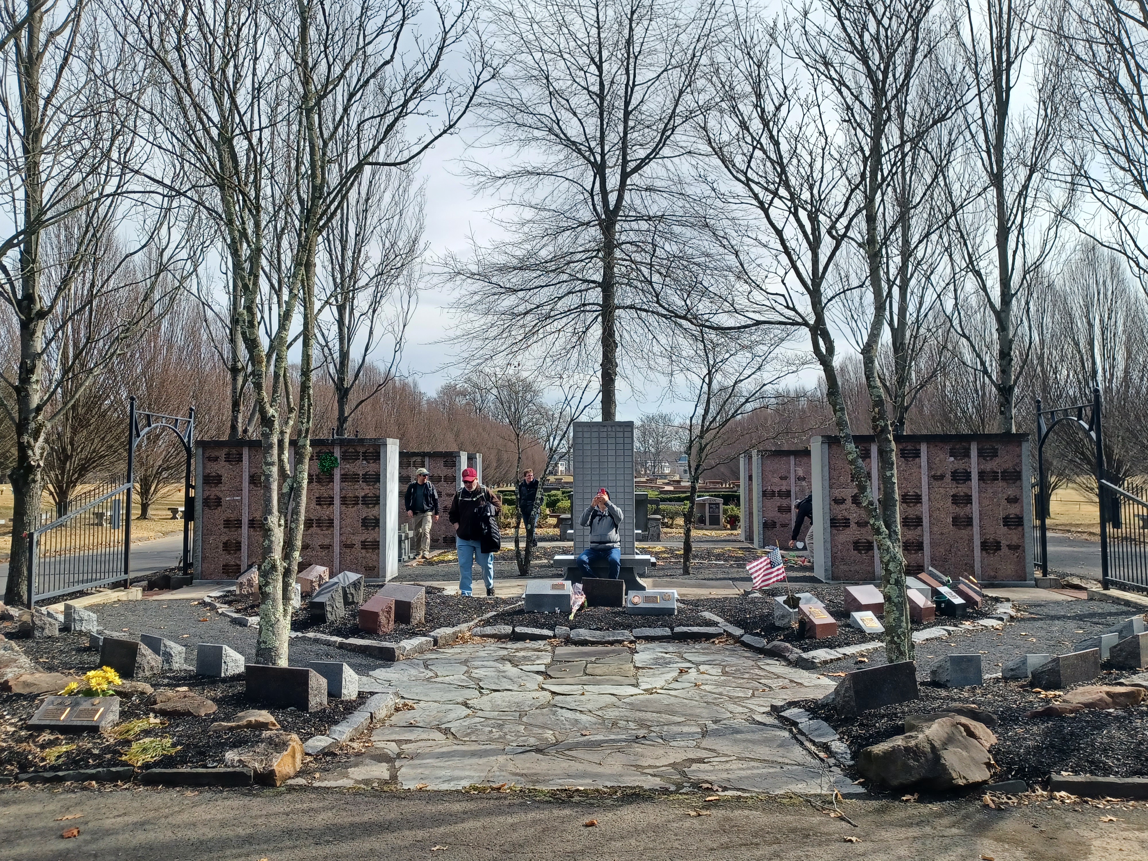
We had to dash across the rather busy road and then approached the main roadway that leads straight to the prominent tower structure.
The tower must be some sort of a mausoleum. It also oddly has cell tower infrastructure on the top of it. In front of it, there is a median in the access road in which there is an area of plaques and markers, maybe people who were cremated and put into smaller memorial spots. It was a very nicely manicured area.
We made our way around the tower to the left, and then further into the cemetery along their nice little roads. We headed to a little traffic circle, and then cut directly across the grass to the north, to an area known as the "Garden of the Gospels". I let Ev out of the stroller in the cemetery, and Jen and Dave took him by the hands to help him walk for a bit. He managed to walk most of the rest of the way through the cemetery before we left it.
The cemetery had some incredibly impressive giant trees in it, which I absolutely love.
It sometimes gets difficult with Ev with the group giving him so much attention. He always begs to be picked up out of the stroller, and he's getting heavier all the time.
As soon as someone complies and picks him up, he doesn't want to be put back down, and will make in incredible fuss about going back in the stroller, which is sometimes absolutely necessary due to traffic. I have to encourage people not to pick him up when he begs for it all the time, because then he won't go back in. I tell them if they pick him up, they have to carry him, but it never pans out that way!
This time wasn't too terrible.
We headed to the northernmost bit of the cemetery, on a paved access lane that came to an abrupt end.
I felt bad because there was one solitary guy out there having a solemn moment at a grave, and this group of very happy people came walking up on him and passed by. I tried to move on ahead rather quickly as not to disturb him, but there was no avoiding it with the group going by.
I waited with the stroller at the edge of the cemetery, where we would have to get back on the road again.
When Ev reached me, I put him back in the stroller, much to his disapproval, but he got over it pretty quickly. He usually does so long as I start walking immediately and he has stuff to see.
We went directly across Chestnut Lane, to the sidewalk on the other side, and turned right. This brought us soon out to the intersection with the Limekiln Pike.
This location was quite pretty, with an old stone house on the east side of the four way intersection. This location was also, according to old atlas maps, once a toll gate site on the Limekiln Pike. I wonder if the toll house might have been the old house in the south side of the intersection, which is extremely close to both Chestnut and Limekiln Pike.
We turned left on Limekiln Pike here, which had no sidewalk so we had to remain on the shoulder. This was one of the crappiest bits of the entire hike. I had plenty of room to get off of the road when I needed to, but it was just not a great way to go.
We headed north toward Eureka for a bit, dipped downhill and crossed a small creek, and then ascended slightly on the other side. There was a lovely old farmstead on the right side that was historically part of the 19th century Stockler Farm.
The next oddball turn was just after the stream crossing. I pushed off to the left of the road into some grass and waited until enough of the group could see where I was going.
I pushed Ev's stroller into the grass, and continued to the west beside a retention pond, and then through a mowed cut in the trees out to Chestnut Creek Park. Both Jim DeLotto and Luke Freselone met up with us at this point, and we'd have a nice little break when we got over to the parking area. We sat on the large wooden poles that were laid out as parking bumpers.
I let Ev loose again, and he took off down a paved pathway that leads to the Hatboro Horsham Hawks football building below. The group kept running down to intercept him and get him to come back the correct way. It was a good break because while everyone else felt pretty rejuvenated, Ev was getting pretty tired.
Luke picked up some hard boozy drink for us on his way down, and so we indulged for the remainder of the hike and had an even better time.
A power line crossed this park at a sort of east/west angle, and we followed that route to the west, out to Lower State Road.
I put Ev back in the stroller before we moved off because I knew we were getting on streets and had some rather unpredictable stuff coming up. He was not happy about it at first, but then contently looked around at everything as we walked.
We turned right on Goodwin Lane for a bit, and then left after a short distance on Stevers Mill Road. This brought us to the same power line that crossed Lower State Road, which we couldn't get on at the time because it wasn't a fully clear route.
I had checked the google street views prior to this hike, and from Stevers Mills, it looked pretty good heading west, so that was my plan.
When we got to the power line crossing, we turned right on it. This brought us up a slight hill, and then to a clearing to the right.
This was part of what is known as Memorial Grove Park, a rather lesser known township park I think.
We soon reached the Korean War Memorial of North Wales.
It reads: "Remembering our history leads to our future. Our history leads the way of spirit and Hope.
For the future and sustainable development of the Republic of Korea - United States of America Alliance that started through the Korean war. We go together.
As a peace park, this Plaza demonstrates our own spirit and our pride, through showing our history and culture, as it evolves into the future, not merely a monument to the Past."
We took another break at the monument, and Ev completely passed out around this time and took a long nap.
Parking for this site is available at Kenas Lane to the west, and Usher Lane to the north. My plan had been to go up to Usher Lane, do another brief road walk, and then get on more trails, but it unexpectedly worked out better than we anticipated.
We turned to the northeast, and the mowed trail led out to another memorial of sorts, this one with a vertical cut off segment featuring outlines of doves on it.
Behind the memorial, the mowed trail continued into a bit of a tree line. We followed it closer to Usher Lane but before we reached the parking area that far along, there was an unexpected trail to the left that entered more woods. I didn't know how much farther it would go, or if it simply would loop back. All I knew was that it seemed to be going more in my intended direction than the original plan.
We crossed over a nice footbridge and meandered through the woods for a bit, somewhat parallel with Kenas Road. Eventually, the trail took us out to the road, but this wasn't a problem because there was a nice sidewalk that stayed back a bit farther from the road than most do.
We only had to go a short bit, and the first entrance to Windlestrae Park was on the left. We turned there, and continued on the path on the other road, and then as soon as we reached the west end of the park, we crossed and began following the walkway around the edge of the ball fields on the west.
The trail meandered along the north side of the field after a right turn, and came to a large parking lot, but we went through the grass to the left, through an opening, and to the historic farm house in the middle of the park, which we visited the last time in this series of hikes while following the Little Neshaminy Creek, which is directly on the east side of the building.
The structure was the historic Windlestrae Farm House in Windlestrae Park, which was built in the 1700s.
I could not find a definitive date of construction or a whole lot if historic information about the home, but I did find that one of the prominent owners of the home was Joshua Jones, a Baptist minister who splintered from the older area congregations.
Jones was known to end sermons with the statement "I leave it with you briefly and abruptly; may God add his blessing!"
We took a short break next to the handsome old home, and then made our way back to where we had been on the previous hike. We followed along the Little Neshaminy Creek heading upstream for a bit, but then we crossed over the first footbridge that led to the other side.
There is still a little more of the Little Neshaminy Creek I have yet to follow from this location, some of which I can still get on, and tie in to the Rt 202 Parkway Trail, but we wouldn't be doing that this time.
I have other plans to make the connections there, which will wait until the weather gets colder again.
Once across the foot bridge, we turned right, heading back downstream along Little Neshaminy briefly, and then left onto another trail which was much wider. It was actually almost as wide as a major utility right of way, only without any poles or pipelines. We crossed a footbridge on this, which wet ever so slightly uphill, and then into a wide open area known as the Zehr Tract. We continued through this and out to a parking area along Stump Road.
Ev passed out when we were back at the memorial park, and remained asleep for quite a while right through to this area.
We turned left through grass parallel with Stump Road only briefly, and then turned right when grass started up again. We moved away from the road through this grassy area to the right side of a retention pond associated with Montgomeryville School.
We continued along the right side of the grass until we were beyond the retention pond and school facilities, and then turned to the left through the fields heading to the far west side.
We had hiked into this before on a trail connection from the southwest previously, but this time we would reach that same connecting trail from the grassy field of the school.
Once we reached the trail, we turned to the right and then passed through a swath of woods before reaching the Rt 202 Parkway Trail.
When we had reached this spot previously, my original plan was to follow the Parkway Trail, but instead we crossed directly and followed oddball pathways on the other side of the highway. That was a good thing for that day, because I didn't have Ev with me.
This time, we would do the stuff on the east side of 202, so a lot of it was all new to me.
The first bit of the trail was directly along the highway, but there was a nice spot that turned away from it just ahead which made it a bit nicer.
This entire section coming up was really nice and relaxing. There wouldn't be a whole lot of thinking necessary on my part until we began turning away from 202 Parkway, so I was able to just push Ev along and relax. He woke up soon, and very much enjoyed leaning out of the stroller and engaging more with the group.
After being in it for a while, Ev got up and stood in the stroller to face forward with the group. If I attempted to switch the seat to face the other direction, he would just stand and face me.
In a bit, we reached the crossing of County Line Road, which was an at-grade crosswalk crossing.
We moved ahead from here, passed a parking area access, and then made our way toward the former crossing of Detweiler Road.
At this point, a side trail passes beneath the highway where Detweiler Road used to continue for traffic, but is now closed.
The site provides access. It was at this point on the previous hike that we switched from following the more informal route son the west side of 202 to the formal one on the east side.
Ahead, we reached and crossed Limekiln Pike. I think this is where Dave and his nephew cut out early, and so did Shane because he had taken a ride with them.
The trail from here stayed pretty close to the right side of the highway for the rest of the time we were on it, but it was a fun time. Brittany had a bluetooth speaker going, and we were all sort of just dancing on down the trail for a while. Ev was standing facing forward in the stroller, dancing along a bit too and just having a great time. Some in the group would scoop him up and hold him for a while during this stretch, and he loved the attention.
Soon, there was a side trail to the right that broke away from the 202 Parkway Trail, my planned route.
The paved trail led us through a swath of woods, and then to a parking area on Stump Road.
On the other side of the road, it continued through farm fields heading southeast. Near a height of land, we passed a capsized old farm cart and took a short break. There was a side trail here that led into the Kings Ct development to the north.
We continued southeast over an access road and then downhill parallel with Pickertown Road. For lack of a better name, the Warrington Township Connector Trail descended to cross another Neshaminy tributary, the Mill Creek, on a new foot bridge, in good view from an historic pony truss bridge on the parallel road.
This was called the Weisel Bridge on Pickertown Road. The original Pratt through pony truss bridge was built in 1893. When it was replaced in 2004, the original trusses were affixed to the new bridge to retain historic ambiance. I wish that would have been done more places locally to me.
Ev got out of the stroller in this area and was holding hands with Jen and Brittany to continue along.
The trail ascended a bit to Mill Creek Road, turned left, and then followed along the edge of the road to a crossing on Pickertown Road. At this point, the trail was not yet completed parallel with Pickertown on the north side.
The trail was well under construction with the three quarter stone subsurface below the future trail surface, which made for some tougher stroller navigation, but we managed. We passed the public works department for the township, and continued parallel with the road on the north side to the intersection with Lower State Road.
Here, we switched sides of the road again, and the trail was completed on the south side as we continued to the east.
Somewhere in this area, Serious Sean joined us to continue for the remainder of the hike.
There were a couple of old homes on the north side of the road as we walked by.
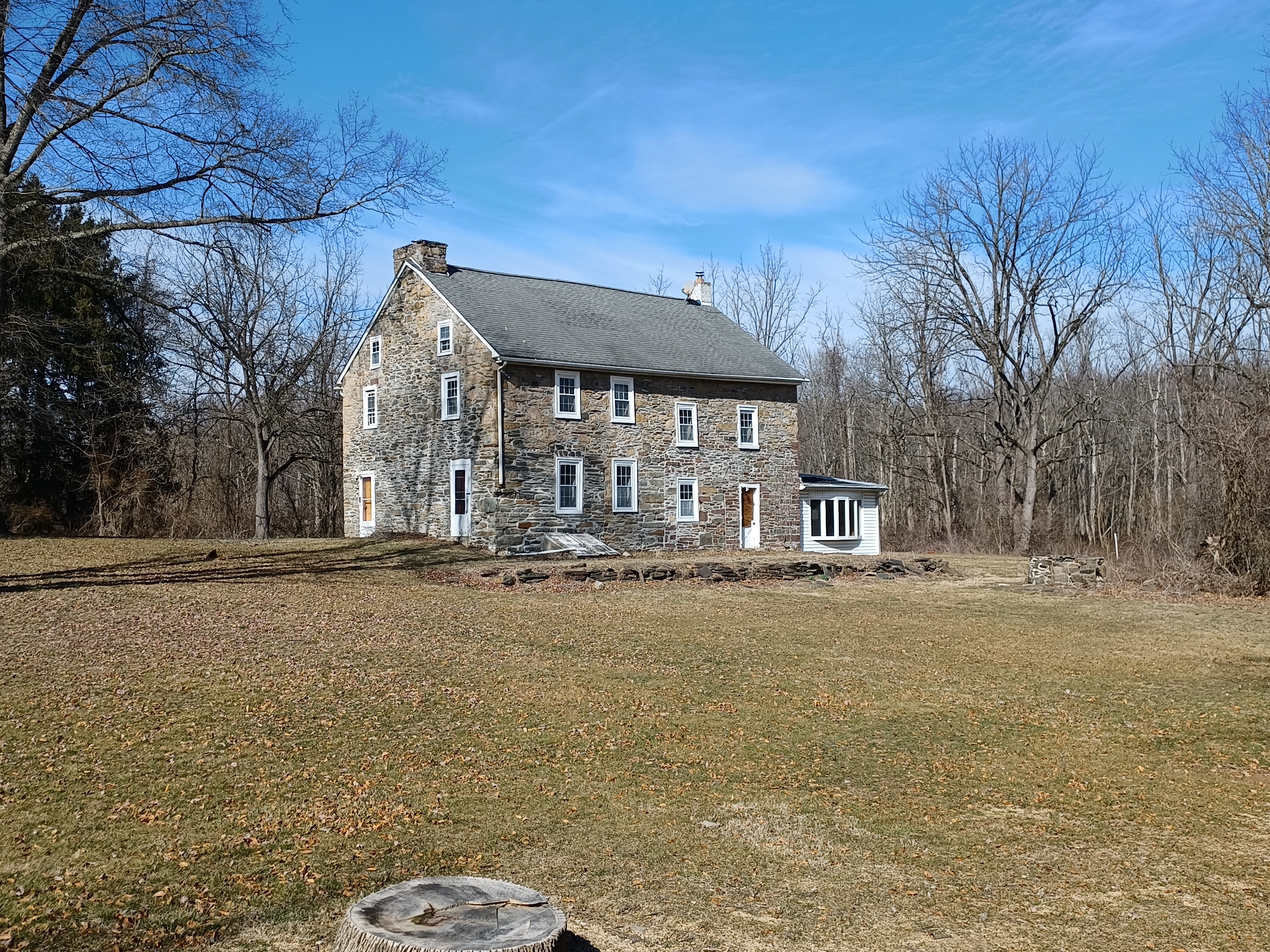
The first old farmhouse was occupied, but the second one we came across looked as though it might have been abandoned. It was a beautiful old stone house with several later additions put on it. Historic maps show that this building was the residence of W. Rapp.
We continued east from this point, and after passing Conrad Drive on the right and Buttercup Drive on the left, the trail turned to the right away from the road.
The trail took us between some developments, and then came out on Street Road. We turned briefly to the right here, and then to the left onto Morning Walk Drive. This road ironically connected with Evening Walk Lane, and sort of between when we were switching times of the day. It made for some funny photo opportunities.
We continued ahead, and pretty soon, a trail broke off from the development into the woods to the right, into Lions Pride Park. This led us downhill slightly on a crushed stone trail, and then to the edge of more ball fields on a path called Nike Site Trail.
We continued along the field edges on what was called the Nike Site Trail. We continued to the south toward Folly Road, and emerged at the intersection of Folly Road and Bradley Road on the south side.
This area may have been part of the former Nike Missile base of the Warrington/Eureka area, and I know the section coming up was part of it, because it used to be called Lower Nike Park. It was more recently renamed John Paul Park at Lower Nike.
In the 1950s, Philadelphia District of the Army Corps of Engineers set up a circle of 12 Nike Ajax missile sites averaging about 25 miles from the center of Philadelphia. They were manned by regular Army as well as Pennsylvania Army National Guard Units.
Most of the Nike Ajax sites were taken out of service between 1961 and 63, but this one might have remained in service it seems as late as 1971.
From the intersection, we headed almost directly across and followed the gravel access road directly into Lower Nike, now known as John Paul Park at Lower Nike.
When we got to the main park area, we kept to the right, and the end of the road became the trail to the south.
We continued into some pleasant woods, and soon close to the Little Neshaminy Creek. We continued on the trail, which then led us out to the power line clearing we had reached on one of the previous hikes in the series. When another trail went over to the south, we continued on the trail we used previously beside Little Neshaminy Creek following it downstream.
It is a really nice section that leads to a large wide section of the creek, and then meanders above it through woods. I really liked the segment the last time we were out, at which point it had a lot of ice on it. This time was much easier in that regard.
After a bit of slight ups and downs through the woods, the trail emerged into a large meadow area, above the Bradford Reservoir. It then made its way to the dam.
The reservoir was created in 1975 as part of a flood protection measure.
It was kind of questionable where exactly we were allowed to be walking from there. The access is off of County Line Road, and the paved trail makes its way below the dam to the south, then cuts into the woods and dead ends in the middle of nowhere. We had checked that out previously. In order to get through to parking it is necessary to go up and over part of the dam to the access road. However, there are signs reading to stay off of the grass and the slopes of the dam, so there's literally no way through to the parking, and no official access to the trail unless you go all the way back to Lower Nike.
We just made our way along the outside and to the access road to get back out to County Line Road. Luke ran over and climbed on the spillway before we moved on.
The access road was known as Bradford Road, and we took that to County Line Road. There was an historic marker with a keystone shape to it along the road on the way out, concerning the construction of the dam and partnership between Bucks and Montgomery Counties.
We followed County Line Road to the east a bit, and soon the paved trail parallel with the road started up. The last time we were out, we skipped this, and instead went through all of the grass behind apartments on the left side of the road.
The path turned to the left to parallel Kansas Road after that intersection, but we cut off of the trail and continued straight on County Line Road. We soon crossed over Park Creek on the way.
There was a little bit of paved trail that started up along the road as we walked, but it wasn't completed the entire distance back.
At some point on the way back, the group was picking cattail plants and setting them on fire, which usually works out pretty well, but this time I recall it didn't want to go ablaze as easily as its supposed to.
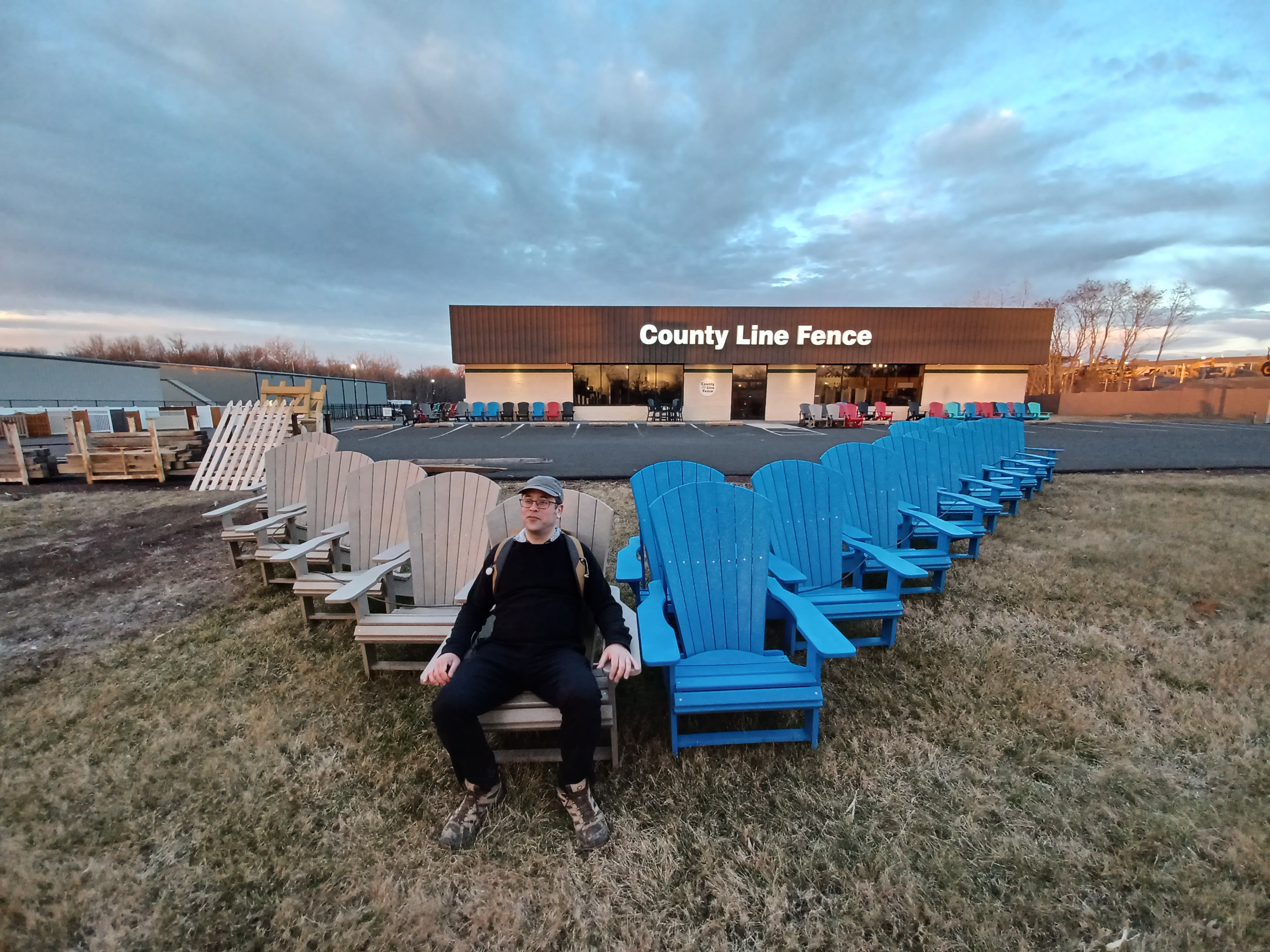
We went along the parking lots for a self storage, County Line Fence, and other businesses. The sun was setting beautifully across the road as we passed by where we turned to the Keith property earlier.
Pretty soon, we reached the parking lot by Regal Warrington Crossing, but we didn't stop there. We were hungry, and so some drove, but some, including Ev and I, decided to head by foot over to the Red Robin along Rt 611 to the east for dinner.
I think the orders got screwed up or something, and it was a bit underwhelming for what the price was, with portion sizes, but overall not terrible.
We had a nice sit down dinner, and then meandered back to the parking lot, which was a bit tiresome after the long day.
In the end, the hike included 11 parks, five historic sites, and one cemetery in twenty miles.
I was pretty tired after all of this, but surprisngly not so bad that I couldn't manage the walk to and from the cars at the end.
It was one of those days where I would never have thought there would be so much to see and so much to learn from a just one route, but for this we barely even scraped the surface. There is also still quite a lot more to explore through the area.
At this rate, I'll still have plenty of strollerable routes long after Ev is out of his stroller!


No comments:
Post a Comment