

Hike #1526; 1/15/23 Mt Gretna to Lebanon with Justin Gurbisz, Brittany Weider, Jenny Tull, Teresa I, Professor John DiFiore, Diane Reider, David Adams, Dan Asnis, and Everen
This next trip would be a point to point, the next in our Pennsylvania Highlands series heading east.


I'm not only trying to do the officially designated route of the Highlands Trail in Pennsylvania, but all of the stuff that connects with it as well.
 |
| 1907 |

I should have been finished with this segment of the PA Highlands the last time we were out in the area, but we ended up following the old route of the Horse-Shoe Trail rather than the new reroutes, and so I had to go back and do the new segments I'd missed before.
 |
| 1910 Journey through the Past Collection |

Rather than just do that section and repeat too much other stuff, I decided I would cover some rail bed to the north into Lebanon, and then do some of the Quittapahilla Creek Greenway, which was also on my "to do" list.
 |
| Around 1900 |

That would put the first bit of it in the difficult ranger with my stroller, and the rest of it very easy on rail trail and multi use trail.
 |
| 1886-88 Lebanon Co Historical Society |

One of the things I have been doing differently as of late is to plan for some of the hikes to go by spots where I specifically wanted to set up then and now photo compilations for the Metrotrails page.


Until recently, all of these compilations were basically incidental things that I took on the hikes, where we ended up going, but recently I have been planning on the hikes passing by these sites to get more of them.
 |
| 1910 |

For this one, I added to the start of it a segment to the former Mt Gretna Station site. It would be an out and back from the actual starting point, which annoyed some of the group, but I thought it would be interesting to look around the site anyway.
 |
| 1917, Roy Rehkugler Collection |

Gregory Pawelski does some amazing then and now compilations and shares wonderful photos from throughout the area, and has some of the best stuff around on the former Cornwall and Lebanon Railroad, so he served as a great inspiration for me to do this hike in the way that I did it.

My meeting point would be the end point, the Burger King off of Rt 422 on the east side of Lebanon.
It would be a good end point because the greenway along the Quittapahilla Creek didn't look to have much left other than one small preserve to the southeast of that location, and I don't think I could get a stroller through. The creek seems to find its start as a spring on a farm just to the south of there.
We met there, and it was a bit chilly at first. I just left my son in the car and didn't bother unstrapping hi just yet because I didn't want him getting cold before we even got moving, and I'd have to drive my car to the starting point.
 |
| First narrow gauge engine, 7/4/1889 |

My starting point would be the same as the ending point a couple of hikes ago in this area, at the hard bend in Timber Road, Mt Gretna PA.


There is still one concrete observation tower on top of Governor Dick Hill today, and most of the right of way is now a trail. It was abandoned in 1916 after a military accident forced its closure. The military used it for a time to reach its facility at Conewago Lake in the last years of its operation.


This military installation was the predecessor to the sprawling Fort Indiantown Gap installation, so it was a pretty big deal.


I thought I had one of the photos figured out and took a shot beyond the fences, but I was wrong.
It turned out that the Hotel Conewago was on the slope on the far west side of the lake. Had I known this for sure, I could probably have done a better job of making compilations in this area.


I found out that the Conewago Hotel had been straight ahead from this location, and that the railroad had a stop somewhere here for it. It was on the hill just above.


I now know that the roads just above us in the development section known as Conewago Hills was the former site of the Hotel Conewago.


The Conewago Lake was created by Robert Coleman in 1885 as a recreational facility for Mt Gretna Park.


I had hiked the entire 140 plus mile trail, and completed the last bit of it I needed just a few years ago, but now there are a few reroutes, and because the PA Highlands Trail is routed on the Horse-Shoe Trail from Lebanon Valley to French Creek area, it makes sense to do this section again and knock out the reroutes.

One slave on the books was noted as “Governor Dick” who lived in a hut on the west side of the hill.

It was a common New England practice for a foundry owner to elect a slave leader and give him a title such as “Governor”, which is probably why Governor Dick was so named.
Governor Dick is believed to have been purchased out of Maryland in 1776, and at age 50, he was the oldest of 25 slaves registered by the foundry owner in 1780.
At the age of 66, Governor Dick escaped and there is no solid evidence of him ever returning to his namesake hill.

The 1105 acres of land were purchased by Clarence Schock, co-founder of the Schock Independent Oil Company, in the 1930s.

Schock felt that after making provisions for his family, his wealth should go to the general welfare of the public. He opened the property to public as early as 1936.
In 1941, aside from a modest living for himself and his wife, Schock decided that his profits should go to schools in the districts served by his company.
Schock passed in 1955, but he had set up a Deed of Trust for the Governor Dick property, so that it would be “In trust forever as a playground and public park”. Lebanon County is now the sole trustee to the property.

The Horse-Shoe Trail skirts the peaks of the hill from the west to the north.

This bit of the hike ended up being much harder than I had anticipated it would be. The first of the two major Horse-Shoe Trail reroutes brought us uphill to the south of where the trail used to go, on a much steeper route. Much of it was old woods roads, but there was a good amount of foot path with rocks. It took a lot of strength and concentration to get the stroller through this. Dave stayed close to me and helped me to lift Ev and the stroller over the really rough spots. The trail would go up, and then slightly down, then up some more.

We started getting pretty near to the top of Governor Dick Hill, to the point that we could see some of the clearing closer to the very top. We started saying to one another that we should have just gone up to the tower. However, if we had done that, we wouldn't have hit the newly rerouted Horse-Shoe Trail stuff, and I really wanted to make sure I was hitting all of that.
Eventually, the trail started to dip back downhill to the north.

On this northern route down, I paused to let the group catch back up to us when I noted it went through a wide flat area. I determined this to be a very old charcoal hearth because it was not only level; where the trail descended from the lower end of it, it was rutted out and revealed the dark black charcoal under layer of soil.
We continued gradually downhill on a better woods road segment, and paralleled a deer exclosure fence to the right. Pretty soon, the Horse-Shoe Trail returned to its original route and we turned right.

We did pass by quite a few other people on the trail, and they kind of looked shocked at the fact that I was pushing the stroller through this mess.
We continued along the easier part of the trail, which brought us close to Rt 117, passed through a parking area, and then started heading back uphill a bit again along an old woods road.
We pushed ahead through the woods until we came to the point where the second reroute turned the Horse-Shoe Trail to the right. 
1985 Gregory Pawelski photo

The turn blazes were also complimented with an obvious arrow. Still, I wanted to wait at this turn to make certain that no one in the group missed it. Dan was in the back of the group, but still moving along pretty well.

Once everyone was caught up, we continued along this new segment. Another side trail went to the left, and ascended another hill that I've never been up, but we would have to save that one for a future hike because I was sticking solely with the Horse-Shoe Trail.
Dave had commented earlier on a rough section that he had to hand it to me for pushing Ev through all of this. It was no easy task getting him uphill with all of the rocks, and I was sweating bullets on it.

This next section was the worst yet. I was able to move along pretty quickly, calculating the point that the front wheel of the stroller would hit.

I was doing a pretty good job of it, but even I was pushing myself to the point of some extreme fatigue where I'd have to stop and catch my breath. My arms were too sore to just keep on pushing, and my calculations on targeting between rocks were losing accuracy.
At one point, the trail went into a very stony field. I had to stop and take some photos of the stroller in these settings, because even I could not believe I was pulling this off while I was doing it.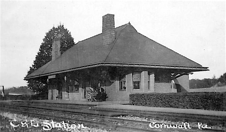
1910

There was a relief that came over me when Route 72 became audible. Another trail came in from the right, and the Horse-Shoe Trail's yellow blazes took us down gradually, almost to 72, but then all of a sudden turned back uphill to the north.

This was a disheartening moment. I was ready to be done with the struggling with this, but the trail got difficult again. I had to continue weaving between rocks, and once again climbing uphill. Eventually, the trail brought us out to abandoned old Rt 72, now closed to traffic and referred to as Mine Road.
The Horse-Shoe Trail continues to the right out across modern 72, but our trajectory from here would be to follow the abandoned highway to the north.
Lebanon Co Historical Society

This was finally the relief I had been waiting for. The ease of walking on the pavement after so many hours of rough stuff was incredible.

We made our way over the peak of the little hill, around a gate, and past the one private house still on the road. We then descended to Rt 117, crossed, and where Mine Road goes beneath the former Cornwall and Lebanon Railroad, there's a path to the right that ascends to the grade. We followed this and re-grouped at the top.
Once everyone was caught up, we continued along the Lebanon Valley Rail Trail to the east.


This brought us beneath Routes 72 and 322, and then past the parking area for the trail at Alden Way, where we had started on a recent hike out there.

We continued past this point, and Heshi went way ahead. I believe he was recording stuff on the trail for the app he's been working on for trail recording.
We crossed Overlook Drive, which goes to a new development, and passed beneath Creek Drive by way of a culvert.
Soon, we crossed over Burd Coleman Road. Just after that spot, we crossed over a through style truss bridge which once carried the Cornwall and Lebanon Railroad over the Cornwall Railroad.

I paused to look at that right of way below us, because that is one of the things I very much want to explore in the near future.

As I understand, the Cornwall and Lebanon once crossed over the Cornwall at grade, at a point just to the east of here, but it was problematic and resulted in many issues, so it had to be bridged.
From the bridge, we could through the community of Cornwall, where the original Cornwall Station stood. I am reading that the station still stands as the police department, but the building does look pretty modern.

To the south on the Cornwall Railroad, the right of way led to the Cornwall Furnace. 
Turn on wifi before passing
The next hike I do in this series, I intend to follow the rest of the Cornwall Railroad south to that site, and the line south from there into more state game lands. I will use this in conjunction with the Horse-Shoe Trail in the next section east from Rt 72 as another loop, in a sort of figure eight. Hopefully the right of way I want to use will be passable for the stroller, as well as the Horse-Shoe Trail.

Some of the toughest stuff I've tried with the stroller have been the Horse-Shoe Trail, but because so much of it is also open to horses, it is within the scope of what I am capable of.

I just have to plan that each of these hikes will be only part Horse-Shoe Trail, and that other stuff is also part of it because doing distance with the stroller over that is very hard.
The Cornwall and Lebanon Railroad shifted from an east to a north trajectory, and we soon crossed over Boyd Street, beyond which the Cornwall Station used to stand.

There is a building to the right, just before the crossing, which looks like a station, and even looks railroad style, but it is reportedly not the station.

I wonder if maybe it used to be offices or something. It just looks far too much like a station.
The station was a handsome stone structure that was built a bit later on the line, because it had an area for the local trolley to come though on the other side. I kind of wonder if the other building might have been an earlier station.

The station burned, as I understand, in 1933.
We took a break here under a pavilion that sits just about where the station stood for everyone to catch up and eat some snacks.

There were soe pretzels going around that someone bought, which were quite delicious. They had some garlic powder or something. I think Dan brought it. He also gave me a breakfast candy bar of some sort of cereal I gave to Ev.
Dan caught up in a short bit, and was doing surprisingly well considering he hadn't been hiking with us in quite a while. The last time he'd been out was the last one out in this series.

When he finally did sit down, I had a bunch of taco bell packets and such in my bag, and I put them into his bag, as well as into his hood without him noticing.

After our break, we continued on the rail grade to the north. It looked extra wide here because the Cornwall Railroad had been directly to the left of us.
After we passed the last house on the left, a side path led over onto the old Cornwall Railroad grade. Although it was easier to be on the Lebanon Valley Rail Trail with the improved surface, this other grade also wasn't bad, so I chose to follow that instead most of the time. At a couple of points, I came back over to the C&L, but then there were good ways to get back over to the older line, so I did it.

To the right of the trail, there was a spot where the Pennsylvania Railroad had its own spur to the furnace area at Cornwall. None of that is a trail today, and the spot where it broke off to the right is pretty obscure.

Another spur from the Cornwall Railroad went off to the west, headed southwest, then turned southeast. I don't kow what purpose it served, but it was definitely there on the 1895-1900 USGS maps with nothing noted at the end of it. I didn't notice any spurs breaking off there when we walked by.
Ahead, we reached the crossing of Culvert Street. The C&L bridge here is still in place and used, but the Cornwall Railroad bridge is long gone.

Because I chose to follow that line, I had to push Ev downhill and back up the other side.

I think the mountain biking cotangent must be maintaining the old right of way wide enough to get on. When we had first gotten on the rail bed, there was a parallel

mountain bike trail over rougher terrain just inside the woods from the grade.
There was a very nice farm view in this area, as well as an old culvert carrying water beneath the rights of way with a sort of riveted iron pipe.

Ev was having a pretty rough day. He was tired and didn't nap much on the car ride over like he normally does, and when he usually takes a nap in the stroller, we were going over some crazy rocks. He did fall asleep back on the easier part of the Horse-Shoe Trail for a bit, but then the second reroute with all of its bumps woke him up again. He started finally falling asleep again when we got on the rail trail portion.

We got up the other side of the former bridge site, and pretty soon the two railroad beds started to separate a bit more.

Both went into deeper cuts that were not shared. There was a tall rock foemation to the right, each line was on either side of it.
We had to go back up and down again when we came to Whitman Road. Going down wasn't so bad, but Ev was sliding down because I let him be unstrapped on the easier trail. As I started pushing back up the hill, he was sliding out, which coke him up, and I grabbed him before he came out too far.

Dave took the stroller for me and I carried him for a while. I think Dave realized how tough it is to push that thing since he did the little hill at the railroad bridge site!

Another weird thing that happened, which justified my using the old Cornwall Railroad, was the fact that Lebanon Valley Rail Trail was closed ahead! I'd not known this was a construction area, and the entire trail was chain link fenced off, but not the parallel Cornwall Railroad. This was apparently due to some sort of power line upgrade to the north.
Justin and Brittany came over a slope at that point saying "I guess we're walking over here".

Some of the group just remained on the closed trail anyway, figuring it was Sunday and no one would be working. That was an accurate assumption.
There were beautiful farm views through this stretch, probably better than there would have been on the C&L line.
Somewhere beyond where there used to be a bridge carrying Zinn's Mill Road over the rights of way, we came to an open construction area where the equipment was parked on the old Cornwall Railroad. It got to be widened out and a little rougher.

When we reached a wider clearing, we were able to cut to the right and get back on the C&L right of way.

There was no other choice at this point because the Cornwall Railroad was overgrown and inaccessible. We were already inside the fence line at this point, so it didn't matter that the trail was closed here.
I think the trail switches from the Cornwall and Lebanon Railroad to the Cornwall Railroad somewhere in this area, because there is another right of way to the right, and the trail follows the one to the left. After a bit, there was a power line on the one to the right.

I believe the switch happens just about where the underpass is for Rocherty Road.
We continued ahead, and there were formal and informal side paths going to the left and right from the trail, but each of them had sections of chain link fence blocking off the right of way and trail. It was apparent that people were still coming out onto it anyway, and we saw one other guy, but overall it was just us.

We continued to the north, and the right of way seemed wider, with more businesses and residences along the edges.

More probably than the last time I walked through. I'd like to do another hike just including all of the other connections to the east and west, because there are so many other trails.
We passed over Wilhelm Street, and then entered a deeper cut, where there was a former bridge overpass site. This would have been where Broad Street crossed over the railroad.

To the right of us, the other rail grade was also in a cut, separated again by high rocks, and the girder bridge over that was still in place.

Just ahead, we came to 8th Street, and I got the stroller over the fences that blocked off the trail. We continued ahead on the open trail, which is paved as we headed into Lebanon.
Ahead, we crossed 10th Street, then closely paralleled a stream that was in a big concrete lined sluice. We then came to 12th Street and crossed, still parallel with that waterway.

At that intersection, there was an oddball display of a tipped wheelbarrow and broken cinder blocks and stones laying on the ground around it, on top of wood chips with two ornamental plants.

I couldn't quite figure out what this was supposed to be, but maybe in season it looks like something.
The Cornwall and Lebanon Railroad broke off somewhere in this area, and the station still stands somewhere on 8th Street. I need to go to it and look more closely on a future trip. There's definitely a lot more to see around Lebanon, but I don't want to burn out on it right now.
We continued on the trail ahead, and to the left was another building that looks like a station, but it was actually the General Office Building of the Cornwall Railroad.
We crossed Chestnut Street, and then crossed the concree lined tributary. Just ahead from there, the trail ended at Rt 422. We turned right there to follow the road to the east.

I contacted Dan to let him know we were headed soon to the Snitz Creek Brewery, and that he could meet us there and take a shortcut. I wanted to be sure to do more of the Quittapahilla Creek Greenway, and so we went out of the way a bit more.
When we reached 12th Street, the "Quitty" as they call it passes beneath 422. At this point, there are trails on both banks of the creek.

I had already followed the one on the east side, so we took to the west one, which has a bit more of a rustic trail on it.
There was an enormous Silver Maple along this route, and good views of old factories on the other side of the creek as we walked.
We reached Willow Street, turned right to cross the Quitty again, and then continued on the southwest side of the creek.

We crossed 10th Street and headed to Partridge Street where we turned right to head toward the brewery.
Along the way, we passed a beautiful church, the St. John's United Church of Christ, which was built in 1860. Like so many other churches, this one struggled to find new membership, and the pandemic was the final blow to it. The church closed in 2020, and as far as I know, it never opened again.

We continued south, past a building with some pretty industrial art on the edges of it, and then came to the Snitz Creek Brewery.

I had to take a photo of the place because I knew Kirk would be sad he missed this one. He had gone nuts about the name "Snitz Creek" when we had crossed it near its confluence with the Susquehanna.
We went inside, and Dan arrived pretty soon. This was a great little dinner stop, and Ev was pretty much perfect sitting inside peacefully, and eating delicious food.

I got a chicken and pasta dish that was absolutely delectable, and others got fries and such they shared with him. He was quite happy about all of it.
I had a wonderful IPA with my dinner called the "Time Consumer", which was amazing. It was a strong one, at about 10% abv. I also tried their more signature IPA which was 9 something percent, and it actually wasn't nearly as good as the time consumer. It was good, but not quite as impressive.
Whenever Ev got a little fussy about sitting still, he was happy to sit on Brittany's lap, just very comfortable.

When we finished with our meals, we headed out of the brewery and headed north on 9th Street for a bit.

This brought us in a couple of blocks right back to the Quitty. We turned to the right along the south side of it and had the perfect amount of ambient light to enjoy the rest of it.
We crossed Gannon Street followed by 8th Street, and the trail remained paved through these sections. From 7th Street to 5th Street, the paved trail continued parallel with a parking lot, but then sort of ended. We just kept going along the creek through grass, and then into another parking area to the east.

I had figured on a route that looked really good for the rest of it that wasn't exactly a trail, but was almost as good.

I think we went back across again at 4th Street, and then again at 3rd Street. We headed to the south, crossed a parking lot, and then turned left on Spring Street.
This barely used street is not a through route for traffic, but it served our purposes perfectly. We headed east on it, past an area of parked trucks, and then past a sort of entrance gate to a business. We then had to turn left into a parking area, turned right to the east and out to Lincoln Avenue, and across onto a side street that led to a dead end. We crossed a swath of grass and continued straight through another parking area, and then out of it onto another segment of Spring Street.
The road was dark, with some homes on the right, and grassy meadows on the left with vehicles and such parked in it. Pretty soon, there were garages and buildings on the left, and Eby Street was the last one to go right. The group started to turn there, but I informed them we'd be going left, onto a narrow driveway which soon became a gravel lane to the right.

The gravel lane took us out to 5th Avenue. We crossed, and then followed another gravel lane almost directly across from this into more darkness. The creek was directly to our left through much of this.
We passed behind more homes on the right, and then some more businesses. There was pretty much nothing but the creek to the left.

The gravel lane continued on though, but no one could drive through on it because vehicles were intentionally parked in between the cut through lanes so they would be impassable. Fortunately, getting through with the stroller and on foot was easy.
We came out to Albert's Body Shop, and there was no more room between the building and the creek to continue ahead from here, but it didn't matter. We turned to the right slightly to reach Rt 422, and the Burger King we'd met at in the morning was just to the left only one tenth of a mile.

We headed over to the Burger King, and Jenny was willing to go back to the start and drive my car back to the Burger King for me while I waited there with Ev. I got him some chicken nuggets or something I think while we waited.
Justin and Brittany sat and waited with me for this time, which was nice, because they helped to entertain Ev. He got up and walked around in the store a bit, which was good for him before the long drive back to New Jersey.
I actually felt great after this one. Normally after eating and sitting down for a while, and especially after a physically demanding day, I am ready to fall asleep on my way home. This time, I felt really great. It had been an excellent day, and I really needed the workout from that earlier segment.
I really hope I can continue as successfully with this series heading to the east. If I can get through on Horse-Shoe Trail as far as Birdsboro, we'll be fine.
No comments:
Post a Comment