

Hike #1592: 2/18/24 Stehman's Mill to Columbia with Eric Pace, "Major Tom" Conroy, James Kohan, Professor John DiFiore, Jenny Tull, Kirk Rohn, Diane Reider, and Everen
This next hike would be a point to point, again returning to Lancaster County for a trip I had planned last year, but changed the route of last minute.

I promised I would come back to my original plan in colder weather, because it involved so much road walk, and so this was a good time to do that.
As always, everything I am doing is some sort of a series, and I wanted to try to cover the Enola Low Grade Line of the Pennsylvania Railroad, as well as the rest of the branch up to Columbia.
I had actually already done the section from Safe Harbor all the way to Columbia years ago, although much of it was done in the dark. Jillane and I stayed out there overnight once and did the entire stretch.

I felt there were still a lot of interesting things to see in that stretch I'd done with Jillane, somewhat off of the railroad, so I wanted to see more of it in the daylight.

I had also already done much of the line below Turkey Hill, so I didn't want to do all of it again. I had to look over maps and see what I wanted to do about another hike through the area.
I like scanning through Google maps for fun, to look for whatever little interesting roads and such there are, and this time I found a few of them I was very keen to walk.
Just to the east of Turkey Hill, several of these back roads were very attractive to me, so I started scaling off distances.

Planning a route is mostly easy, except the beginning and end points. I knew I wanted to end at the southern end of the Northwest Lancaster River Greenway in Columbia, where we'd started a previous hike, and we'd connected on PA Highlands and Mason-Dixon Trail.

Looking to the east of what I had initially considered, I found the Boyer Nature Preserve. There were no trails in it, but I did find an access to the Little Conestoga Creek, right about where I needed it to be in order to come up with a reasonable route.

In the days leading up to this hike, we got probably the greatest accumulation of snow for the entire Winter. I was slightly concerned about doing the hike, but happy that I'd planned one on this occasion that would be more heavy on road walking.

Even greater, the area along the Susquehanna River had far less snow accumulation than we'd gotten back home. Things were going to work out just fine.

We all met at the parking on Locust Street in Columbia, near the Columbia Crossing River Trails Center. This was the historic location of the start of the Pennsylvania Canal heading north. A connection was made from the Susquehanna and Tidewater Canal on the other side, which had its terminus at Wrightsville.
Columbia is a pinch point in transportation history, and therefore the same for the hikes I've planned. With Pennsylvania Highlands superimposed on some of these, it reopened my interest in coming back. We'd recently done the Mason-Dixon Trail through on the other side, the Northwest Lancaster River Greenway to the north, and this time we'd come from the south.

There are two other historic railroad lines coming into Columbia I still want to do, the most significant of which is the Philadelphia and Columbia Railroad, but that too will be a Winter trip.

We all shuttled in as few cars as we could, just two of them, to the start point on Stehman Church Road. I found the preserve had a pull off parking next to the bridge over the Little Conestoga Creek that could fit a limited number of cars.
As soon as we got out of the car, and while I was getting Ev situated in his stroller with all of the supplies, I noticed some stone ruins out in the weeds. As soon as he was in, I went over to check them out a little bit better.
These looked to me like old bridge abutments, but I couldn't be sure.

I referred to the old Everts and Stewart atlas maps of Lancaster County, Manor Township, during the course of the week, and got the answer.

I assumed it was a bridge correctly, and it made sense because Stehman Church Road is on both the east and west sides of the Little Conestoga Creek, but neither segments of them connect with one another. Our route would be to take Stehman Church, but in order to do this, we had to go left on Walnut Hill Road, and then right on Stehman Church Road.
Back in 1875, when the maps were made, the road used to go directly across the river straight.
There was an old road of some sort that went down along the creek from where we were parked, which I think is part of the Boyer Preserve, but we didn't have the time to be doing too much extra miles here.

The nearby Walnut Hill Road bridge isn't exactly new either. It sits on stone piers and abutments, and might not be the original span on that location. The current one is a deck girder structure.

Immediately adjacent to the bridge is the old Conestoga Feed Mill, now a private residence. It was also known as Stehman's Mill and Mellinger's Mill.
The mill was built in 1818, but there is evidence of mill works at the site as early as 1792.
It was a flour and grist mill, but also ground cornmeal and was used as a distillery/cider mill at times, as well as other uses. The mill employed two turbines and one overshot water wheel.

In 1902, the mill burned and closed, and was rebuilt, interior framed out.

The Milling operation was closed by the 1900s, and it was a secondhand store for a time. It was converted to a home in the 1980s and is beautifully kept with added skylights and landscaping.
Prior to colonization, this area was one of the largest settlements of indigenous people east of the Mississippi. On these land it is said that major conflicts occurred between the local Susquehannock and Seneca people of present-day New York.

We turned left and right to climb up Stehman's Church Road, which seemed pretty steep. Fortunately, although there was a coating of snow all around, the road remained pretty clear and not slippery.

Stehman Church Road was not the one I'd chosen among the best ones to walk, but rather a thing I had to do in order for the other ones to work.
I usually judge roads for the quality for walking by whether or not they have lines in them. This one did, but we had to walk this way to get to Indian Run Road.
When we reached the Stehman Church property itself, we turned to the left, up the driveway to it. We passed through the property and past the church, through the parking lot, and came out on Indian Run Road. We turned right on that to reach Stehman Church Road again, as this was not the bit of Indian Run Road that I planned on using.
 |
| 1950s Conestoga Feed Mill by Elizabeth Schreiner |
We turned left again on Stehman Church for just a little bit, and when that main road turned to the right, we continued straight, downhill on Indian Run Road.

We descended a bit on the road and reached the crossing of Indian Run. The crossing was partially an historic stone arch bridge, for which I could not find any information on date of its construction.
The upstream side seemed to retain its historic stone character, while the downstream side was more of a concrete deck material dating to whenever they decided to widen it.
The walk was really very windy, and it got better when we got down in the gully along this road, but we faced more wind when we ascended yet again.

We emerged at the intersection of Safe Harbor Road and Coffee Street, at some really odd looking hills.

We continued straight across on Safe Harbor Road, and twisted to the left uphill without a really good shoulder. This was a busier road with lines, but there was no other good way of going about it.
We continued up the road to the intersection with Indian Marker Road, where we turned right.
Across from this intersection, is the "indian marker" for which the road takes its name.
The marker was placed because it was in this area that the Susquehannock or Minqua tribes settled.

The stone memorializes the native heritage, placed one hundred years ago, in 1924.

Sadly, after years of peace with William Penn, the remainder of the tribe was murdered by the Paxton Boys, an unruly group of anonymous and unsanctioned militia, in 1763.
No one was ever charged with the crime, and only one minister is really proven to have been involved with the evil deeds.
We continued along this very pleasant road through some beautiful farmland. The homes and buildings were all stunning.

There was an old stone farmhouse on the right, which on the 1875 atlas had belonged to H. Hershey.

We continued further up the road, through what the atlas said had been the Garber Farm, and took in all of the views. I kept the carriage cover over Ev to shield him from the wind.
To the right, on one of the farms, there were horses out next to the road. We got to stop and see them more up close, which Ev really liked.
We continued west, and crossed Highville Road, and then continued to the west in Indian Marker Road, which remained pleasant.

We continued west on Indian Marker, and came to the corner of River Road. There was an abandoned house or farm stand or something on the northeast corner of the intersection here.

Directly across from the intersection was a small parking area and entrance to Chestnut Grove Nature Preserve. We entered the parking lot and took a little break.
My intention had been to go to the north a bit and visit Creswell Park, where there is an historic home known as the Rieber House, but I chose against it even though it seemed there was now an off road connector trail. We had a ways to go, and the trails had snow on them.
We took the trail from the end of the parking lot directly back to the west. The snow wasn't too terrible to push through, and in fact, was sometimes totally clear on the trail.

We kept to the right, and then made the third left from the mowed trail onto a crushed stone one that descended slightly and crossed the Fisherman Run on a boardwalk section.

Soon, we reached the main parking area for the preserve. I had hiked this preserve before, but not nearly all of it. I wouldn't even cover all of the trails I hadn't done this time yet, but we'd do a good bit.
We reached the wide, main trail into the park land, a 170 acre preserve established in 2015 atop a capped landfill.
We continued on the main access lane, crossed Fisherman's Run again, and reached an intersection near an abandoned little building. We then turned left on the next trail, which is soon part of the Turkey Hill Trail.

Last time out, we followed the Turkey Hill Trail to the east of here. That was a really rough section with a steep spot that I had to carry Ev through. In these snowy and icy conditions, I would not have tried that.

I understood that the trail to the south of where we were on it before would be much easier. If not, we'd have to go an alternative route.
Where we had previously gone out and around the large bit of filled land to the west, this time we went to the left and followed the wide trail that paralleled the Fisherman's Run to the south.
This was pretty easy and clear for a bit, and then we passed a guy walking the opposite way who told us it was about to get a bit wet ahead. I never know what to think when I hear warnings, because most people are shocked what I bring the stroller through.

Then again, sometimes they are right and I and grunting and cursing my way through it all.

There was a little loop at the end of this lower part of the the Chestnut Grove Natural Area, and we started by going through the lower part, off to the left.
The snow got to be really rough here. It was a lot of work pushing Ev's stroller through it. As we had gotten into the off road parts of the preserve, he fell asleep.
It was a narrow bit of trail, and the stroller felt like it was going sort of sideways, but Ev stayed asleep. At the end of this part, it turned ninety degrees to the right, and climbed steeply.

It took a lot of effort to push the stroller uphill through this snow, but I managed. I got him to the very top, and there was a bench there in a level, cleared area.

This area had some views to what was known as the Star Rock Farm, which we walked by on the previous hike out through this area.
From here, at the bench on the top clearing, there was a dead end spur trail that that led to Star Rock itself. This was a promontory that far exceeded my expectations.
Jenny stayed with Ev sleeping in the stroller while I went with some of the others out to the rock.
The view through the trees was great, but the view from the rock was absolutely outstanding.

We could see way down the Susquehanna River to the Safe Harbor Dam, which was built in 1931.

Prior to the dam, the area was known as the Conajohela Flats. The inundation created by the dam is known as Clarke Lake.
There was barely any snow in this area, so we didn't have to worry about slipping and falling here as much, although if we did, it would have been certain death. It was close to vertical down to the Enola Low Grade line below.
We could see directly across to the bluffs on the other side, where the Mason-Dixon Trail passes along.

The most prominent spot in view as the gully created by Cuff Run, one of my favorite spots on that trail.

Cuff Run was a great spot where, when I first backpacked the trail with Jillane several years ago, we camped. There is a great pool of water, there was a shelf thing, and a nice spot to erect a tent.
There was also a wildlife blind out onto the Susquehanna below it all.
More recently, I had hiked it again after Ev was born, in my Mason-Dixon Trail series. I was able to get down to almost the Safe Harbor Dam on that, but when Ev was born, I had to put all of that on hold because it was just too difficult to do all of it with the stroller.

Sadly, this area is slated to be destroyed as some sort of new pumped storage facility by the power company I understand. There is a grass roots effort to save Cuff Run. What happens to the Mason-Dixon Trail through this area is also uncertain.

From where we stood, we could see in the snow, the Mason-Dixon Trail switchback up from the south side of Cuff Run, which was pretty cool from a distance.
Below us, we could see initials and etchings in the rocks, at least one of them from 1930.
We all made our way back uphill from Star Rock to the trail and the bench.
From there, we started heading out along the height of land, on the far end of the lollipop loop we had started on the other side with.

Pretty soon, at a slight descent, we reached where the Turkey Hill Trail traverses the slopes.

This was far easier with the stroller than the trail is at its north end, where there could be deadly falls and no way of pushing Ev through it in the stroller.
This one was an old woods road that switched back down the slope.
I was able to get down the first bit of it with absolutely no problem. It wasn't until about the time of the first switchback to the left that it started to get a little bit tougher, and I had to wait for the group to help me through it.
Eventually, I took Ev out of the stroller briefly to get through a washout, and then soon put him right back in to reach the bottom again.
We emerged at the end of Turkey Hill Trail on Enola Low Grade Trail and regrouped once again.
The line was built as the Atglen and Susquehanna Branch of the Pennsylvania Railroad in 1906 as a mostly freight bypass of Lancaster.

The original main line route through town was much at grade and even when rerouted there, it had a lot of liabilities, as well as conflicts with heavy passenger use.

The new line had few or no grade crossings, and allowed for trains to travel at faster speeds.
Below the trail are still active tracks, an earlier line that was also part of the Pennsylvania Railroad.
These were built in 1877 as the Columbia and Port Deposit Railroad.
I let Ev out to walk a bit when we got down to the railroad bed, but it was cold and he was really in no mood to be walking much. Changing his diapers in this cold was no happy time, but there was no snow left on the railroad bed, probably because it was so close to the river, so it wasn't too bad.

Pretty soon, he wanted to get right back in the stroller, so I didn't push him to walk too much.

We continued along with excellent views of the Susquehanna River along the way.
After continuing upstream a little bit, we came to Mann's Run, where there was a scenic little waterfall to the right of the trail.
It was a rocky little spot, but I had the group stay with Ev as I made my way over for a better view of the cascades. I then climbed down the concrete wall and down to the edge of the creek.
Mann's Run has a very interesting trajectory where it is conveyed from the falls on the slopes above the Susquehanna River, beneath the Enola Low Grade Line, and then over top of the earlier Pennsylvania Railroad by way on this concrete aqueduct, to spill off into the river.

I didn't want to go out too far with potential for ice, because I'd surely slip off to my death.

We continued north along the trail, and along the way occasionally passed an old mile marker from back in the railroad days.
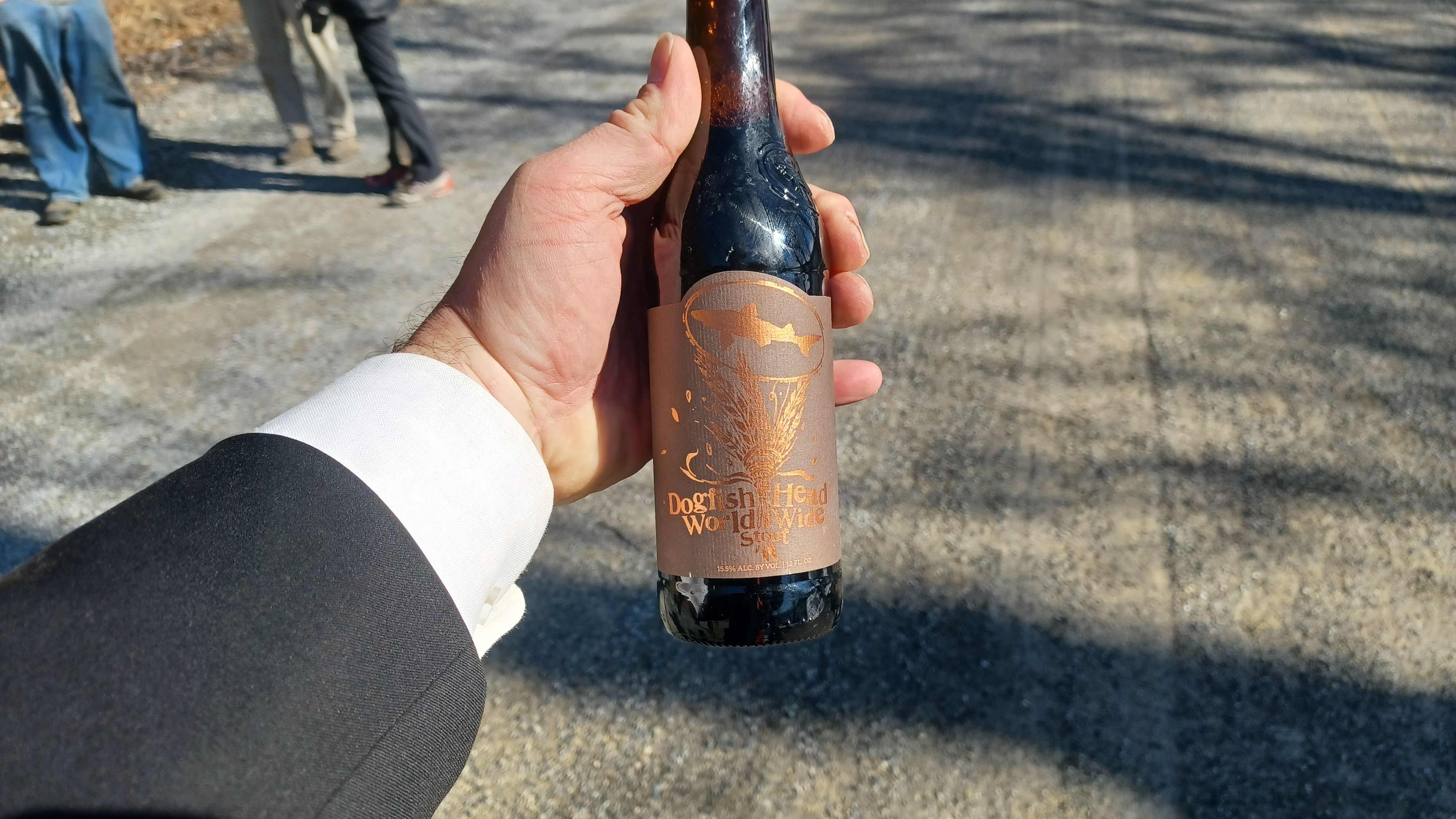
Now that I was done with the really tough stuff, it was nice that I was able to relax, and I popped some World Wide Stout by Dogfish Head that John had given me at the start, a really good and expensive brew.
We continued around a bend of the slope, and had some great views of the slopes across the Susquehanna. At some points, I pointed out to the group where we'd hiked on the Mason-Dixon Trail there previously.

One of the points of interest I recognized was the old site of Lock 2 on the Susquehanna and Tidewater Canal at Shank's Mare, and the outfitter we stopped at in view.

The slopes we had walked along by Fishing Creek were also in view just to the south of that.
In the far distance, we could barely see the Columbia-Wrightsville Bridge over the Susquehanna beyond the wide section.
We soon came upon an old concrete railroad shelter to the left. I'd seen this before on hikes, including with Ev, but he's getting old enough now that he might appreciate more of these things.


We paused here for a bit to have a look around, take a break, and I had some then and now history compilations to try to set up.
We moved on from here, and pretty soon there was an old caboose on display to the right.
I don't know my rail cars all that well, but this one was painted with old Pennsylvania colors, but I understand that it is actually not a Pennsylvania Railroad caboose.
Ev got to climb on this a bit as we continued on. There were also some observation platforms along the way that provided for views, over the chain link fences to the left.


This right of way has a whole lot of money put into it, because as I understand, when the railroad let it go, they also provided a stipend of money to each municipality it ran through to re-deck bridges and such.

An interesting thing happened at Safe Harbor, where the trestle was never re-decked. I assumed this was because it was in two townships, and they didn't want to work together to get it done.
As a result, all of these extra whistles and bells were added along the trail to spend the money from the railroad, and never do up the trestle.
After both sides were done, it sort of put the feet to the fire, and more help was necessary to connect the trail as a through route.
We continued ahead, and there was an historic marker with photos of the original railroad down along the Susquehanna below, with some cool rock formations.
Early 1900s John W. Barriger III

I recently heard that this was changed, and that the 1877 line had been moved up because it would have been below the waters of Lake Clarke.

We continued to where accesses to the Turkey Hill Trail began appearing on the right, before the parking area. The windmills had been directly above us, which power the Turkey Hill Dairy.
The famous Turkey Hill ice cream and milk products are all from this location, and the two windmills power the entire facility. We had hiked to the windmills on our previous hike here.
We continued on to the parking area for the trail, and then the official end of the Turkey Hill Trail where we had come out before, and then continued north.


Pretty soon, we reached the end of the parking lot, and the end of the trail. Just ahead, the right of way continues but is fenced off, and crosses over a set of active tracks from the older line below us.


I had hiked through on that with Jillane years before, but this time we would have to head out of the preserve to the east along Wisslers Run, to River Road.

This was the part I was sort of dreading of this hike, road walking most of the way to the end, but it ended up being really quite interesting and I very much enjoyed all of it a lot.
We turned left when we reached River Road, and there was a sign reading that this was once part of the Great Minqua Path.
All of River Road in Manor Township, is apparently the historic route of the Great Minqua Path, aboriginal fur trade route of the Minqua (Susquehannock) tribes.
Before the dam and Lake Clarke

We continued up the road, which had very little shoulder on it, but much of the time I could get onto grass or into the edge of fields with the stroller.

After a while ahead, Funk's Riverview Greenhouses and Produce Stand was a pretty scene on the left side.

River Road had been above and farther away from the railroad tracks and river for a time, but after Funk's, started descending and turning toward it a bit.
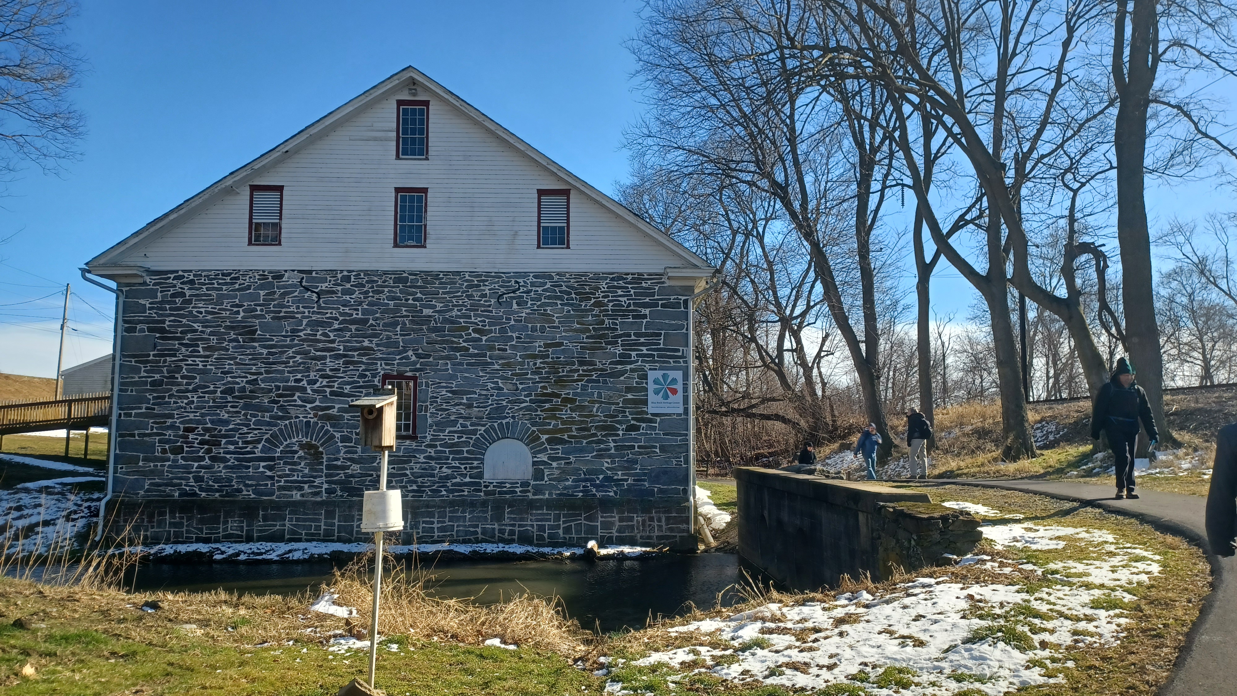
Soon, we came upon a lovely mill and farmstead on the left, the next leg of our journey.
This was the Blue Rock Heritage Center's Wittmer Grist Mill, or Blue Rock Mill, built in 1832.


It now serves as a museum to our ancient and more recent past, managed by Washington Boro Society for Susquehanna River Heritage.

We made our way down from River Road to the building on a dirt road. Unfortunately, it was not at the time open for tours, so we had to just go by and admire the building.
We walked around the left side on a trail, and then right, between the railroad tracks and the mill.
The trail continued past the mill, and then crossed over the stream known as Witmer's Run.


There was a handsome stone arch bridge that carried River Road over the run in view from the bridge.

A paved path continued from Witmer Run, ahead to the Blue Rock Heritage Center's Wittmer Barn, built in 1856.
This building too serves as another annex to the mill museum as I understand.
The paved trail continued past the barn to the Blue Rock Parking area, which let out onto Blue Rock Road. To the left from here was the Blue Rock Boat Launch, which was a pretty spot. We crossed the tracks briefly and had a look at the view.

We continued back up Blue Rock Road to River Road and turned to the left to follow it north.

At the first house on the right, there was a miniature Stonehenge built into the rock garden on the front lawn.
We continued up the road past a few residences, and then crossed over Dry Run.
This stinky spot is now used as an outflow to the nearby sewage treatment plant, which isn't really visible from the road.
Ahead, there was a lovely farm to the left near Washington Boro. The 1875 Everts & Stewart Atlas of Lancaster County seems to note this as once being a Herr family farm.


Soon, Herr Street came in from the right, and River Road turned ninety degrees to the left, then ninety degrees to the right again as we entered Washington Boro.

At these turns, we went straight ahead into the Washington Boro Park and passed by some odd looking trees, and then headed over to the playground. I gave Ev a diaper change, and let him run amuck on the playground while the rest of us took a little break.
It's always a nice time when we stop with the group, and they play on the equipment with him. Diane usually goes down at least one of the sliding boards with him.


It's really a reminder to never grow so old that fear of judgement supersedes prospects of fun.

I think our group excels at this concept pretty well.
Once we were done in the park, we continued ahead to the end of the park onto Penn Street. We went left and reached River Road to continue walking to the north.
We passed a few homes, and the intersection with Elizabeth Street, and then reached a small bridge over a creek.
This was the historic site of J. Stamens Sawmill on Stamens Run. This might also be an earlier bridge site, a predecessor to the bridge carrying the road now. I noted some stonework in the left side of the creek as we crossed, and I can't tell whether or not that was some sort of remnant of the mill, or part of an earlier bridge.
The road ahead was known as Water Street here, and it is also Rt 441. We continued past a farmhouse and another field, and then reached the Washington Boro United Methodist Episcopal Church on the right.
The building was constructed in 1854, and rebuilt in 1872. It replaced an earlier 1838 wood frame structure.

We headed uphill next to the church building, with some help on some steps, and then continued uphill next to the building.

There was a cemetery directly behind the church, and beyond it, the Church of God.

We passed through some of the cemetery and headed to the left a bit, and onto Rockfish Street to the east just a bit to the Church of God.

The building has an interesting history that dates back to before it was the Church of God.
The Blue Rock or Blue Presbyterian Church was established here in 1826. By 1835, the congregation was dwindling, and the church was leased to Church of God.
Church of God constructed its own building in 1844, and the old Blue Presbyterian Church was used as a tobacco warehouse until it was demolished in 1861.


It was a very pretty location, and we turned around directly opposite this church to follow Market Street to the north through the Boro of Washington.

The settlement was originally known as Woodstock, near Blue Rock, and laid out for development by Jacob Dritt in 1811.
Dritt divided land into 122 lots sold by lottery.
There were once two communities, Washington and Charleston, but they were consolidated into one.
We passed by a former fire department building, and continued on Market Street, which was a tiny and very pleasant road.

Soon, we reached Charlestown Road. I suppose that means that this section of the settlement was once the part that was known as Charlestown. Maybe the section where we passed through the park was the original Washington.

We had to go slightly right, and then left to continue on Market Street.

The road reached a ninety degree turn to the left, which we had no choice but to take. This was Conestoga Street. Then, we turned right on an unnamed, unpaved alley to continue north.
This was a very pleasant road to follow, and soon we crossed over Shuman's Run on it.
In this area, we crossed what is known as "The 40th Parallel". The charter awarded to Maryland in 1632 drew the line that crossed the Susquehanna River in this area, originally claiming it for Maryland. It conflicted with the charter granted to William Penn in 1681.
Over eighty years of legal disputes ensued until a survey was undertaken from 1763 to 1767, which drew a great deal of fame and established the Mason-Dixon Line.
There is an historic marker to the 40th Parallel just to the west on River Street from where we were.
We crossed Manor Street ahead, and continued on the unpaved lane to the north.

We did the same over Rapho Street and Donegal Street, and had to cut to the left again when we got to Wood Street, back to Water Street.

There was a reasonable enough shoulder heading north on the main road for a bit from here.
As we walked, we passed by a really nice old abandoned house on the right.
Just after that, we reached Front Street, and were able to turn right again. We then walked another unpaved lane a block up from Water Street for a little ways.

We continued on this to Willow Alley, turned left, and then reached Water Street for the last time. We'd have to follow the bigger road for a bit from here.

The height of the land to the right of us got more dramatic and steep, and there was little in the area except for the road and the railroad tracks to the right.
I've been told that the original tracks, at the lower level, are down in weeds on the near side of the tracks, but I didn't look or notice them.
To the right, there were foundations and old driveways built into the steep slopes, where houses used to stand.

We continued ahead, and between the road and the tracks were parked an antique military fire engine, as well as an old military ambulance.

We continued ahead, and the trees along the tracks disappeared, affording us some outstanding views.
There were great views of the Columbia-Wrightsville Bridge up the Susquehanna River.
The first bridge to cross here was a covered bridge completed in 1817, just downstream from the current bridge. The 5,690 ft bridge amazingly had 54 piers. This was destroyed by high water and ice in 1832.

The second bridge was completed in 1834 just upstream from the current one, and utilized only 27 piers. It was fitted with 2 towpaths for mule traffic towing canal boats, to accommodate traffic between the Susquehanna and Tidewater Canal on the west side and Pennsylvania Canal on the east.

After 1856, it also became a railroad bridge. Because of the fear of fire, trains were towed across the bridge by horses rather than locomotive.

The second bridge was burned by Union forces during the Civil War to thwart Confederate advances, and the bridge company was never reimbursed for damages. All interests in the bridge were sold to the Pennsylvania Railroad in 1864
The third bridge was also a covered structure, built by the Pennsylvania Railroad in 1868. It carried the railroad, carriageway, and walkways. This bridge was destroyed in 1896 as a result of the Cedar Keys Hurricane.

This, the 4th bridge to cross the river at this site, also on the same piers, was completed in 1897. It was of steel construction, and also carried railroad, carriages, walkways, and eventually automobiles. It was also planned to have a second level that was never completed.

The opening of the Lincoln Highway in 1925 caused major traffic issues, and so the current bridge (Veterans Memorial Bridge after 1980), was opened in 1930. It too has a great pedestrian walkways.

The steel bridge carried passenger trains until 1954, and freight until 1958. The bridge was dismantled in 1963 and 64.

The current bridge carried US Rt 30 until the opening of the Wright's Ferry Bridge just upstream in 1972.
Some of the group went out and walked on the tracks through this section, which were double.
We continued a little bit ahead and came soon to the intersection with Blue Lane. Just beyond that was the crossing of Strickler Run.

Fairview Mills once stood here, and Strickler Run was dammed atop the cascade to power the grist mill that stood off to the left of it.
The remnants of the last incarnation of the dam were still partially in place, and stone foundations were clearly visible to the left.
We continued across the bridge ahead, and then reached the former western terminus of the Philadelphia and Columbia Railroad.

This railroad was part of the state-owned Main Line of Public Works, the series of canal and rail that went from Philadelphia to Pittsburgh.

he Philadelphia and Columbia Railroad was completed in 1834 between the two towns. It was originally assumed that the route would not utilize this railroad, but then the canal was extended farther south from Highspire and Middletown to reach Columbia to the south.
The railroad was mostly level, but it employed two inclined planes, at the eastern and western termini. We had somewhat recently hiked the Belmont Plane in Philadelphia, but the Columbia plane was right here.
Early 1900s John W Barriger III

I didn't know a whole lot about the layout, but I knew Plane Street was at about the location.

It seems that the lower end of Plane Street deviates from the historic route of the inclined plane. It looks like it goes more directly down the hill, and beneath the later, still active, Pennsylvania Railroad tracks at that location. I saw what I believed to be evidence of the former plane just a little south of the location of the present day bridge.
The Pennsylvania Railroad purchased most of the Main Line of Public Works in the 1850s, and utilized much of it for their main line corridor between Philadelphia and Pittsburgh. Most of the general route of the P&C is still the active railroad, but some deviations, such as the inclined planes, occur.

We continued to the north a bit more, and a stream passed beneath the road and railroads, which were now skirting us to both the left and the right. Old stone work was in place in these.
We turned left when we got to Union Street, and then turned right on Locust Street, parallel with the tracks.
This brought us right back to where we were parked. As we walked this last bit, a train was going by on the tracks to the right of us. I stopped with Ev to watch it closely as it passed.
1911 view of the station
I had the group stand with Ev for a few moments while I set up a couple more then and now comparisons to close out the day. One was an easy close one, but the other I had to go to the historic railroad station on the other side of the tracks.

This hike left me with a whole lot of things to look up, and actually a whole lot of things to revisit for future trips. It's these back road things and all of the little historic sites that always seem to exceed my expectations for a great walk.
No comments:
Post a Comment