

Hike #1600: 4/7/24 Frenchtown and Bulls Island Loop with Diane Reider, Jenny Tull, Robin Deitz, Kirk Rohn, Justin Gurbisz, Evan "Joe Millionaire" Van Rossum, Alyssa Lidman, Shayna Michaels, Conrad R. Blease, Alyssa ?, Nicole Hahn, and Everen
This next hike would be a good one closer to home, and one that I'd already done before, but not in a while.

I'd done hikes on the NJ and PA side of the Delaware River through this region for years, and even this exact hike I had done before as a night hike.
After Ev was born, I started doing all of these different sections as loop hikes, but I hadn't gotten around to bringing him on the sections between Frenchtown/Uhlerstown and Lumberville/Raven Rock.
I figured this would all be easy stuff, and we could just power on through it all without a problem. If it came out to be a little more mileage, it wouldn't matter because it was all so easy and straightforward.
This turned out not as planned, and we ended up having a bit tougher time than anticipated.
 |
| Post 1903 |

Because this was hike 1600, I wanted also for it to be something that would be pretty easy, be along water at least a good amount of the time, and be a loop.

Parking is also easy for this one, especially if starting in the morning.
The Station Cafe in Frenchtown, in the old Belvidere Delaware Railroad's Frenchtown Station, uses the spots closest to the building, but I posted to have everyone meet a little further down Old River Road.
It was nice to not be traveling so far for a hike for once. I had been spending a whole lot of time going to all of these farther away places, which I love, but I do like to revisit some of the old favorites.
It was also great that my old friend Conrad would be back for hike 1600. Conrad was out on Hike 1 with me in 1997, and he is the only one of of the participants on that first hike to still rather consistently come out over the years.

Conrad was and his entourage were running a little bit late. He was bringing two newcomers who were having trouble getting to the meeting point, so he wanted behind a bit.
I started the group out by walking up onto the Bel Del rail grade, and then up to the Frenchtown station where I gave everyone the history.
The station is likely the only one of the original Bel Del Railroad remaining. Most of the stations form the original line had been eliminated over the years.
The "Bel Del" line was established here about 1852. It was taken over by the Pennsylvania Railroad in the 1870s. Some of the original stations were just repurposed earlier buildings, such as Lambertville, until the current station building was completed.
Frenchtown however, was never torn down and replaced. Rather, the Frenchtown station was dramatically altered, and made a much smaller size. The original was something like one and a half story, and much longer, but then it was cut down. The ticket window protruding was left in the same place.

When the current cafe was opened in the station, it appears to have been lengthened again, and a new awning was added back on for additional outdoor dining.

Freight traffic continued on, with some quarry customers along the Delaware River until Conrail in 1976. By the early 80s, and with the exception of a section near Lambertville, all of the Bel Del was removed from the paper plant below Milford to Trenton.
Today, the section of the right of way is a state park rail trail in Delaware and Raritan Canal State Park. The state park service has it from a point just north of Frenchtown down to Trenton.
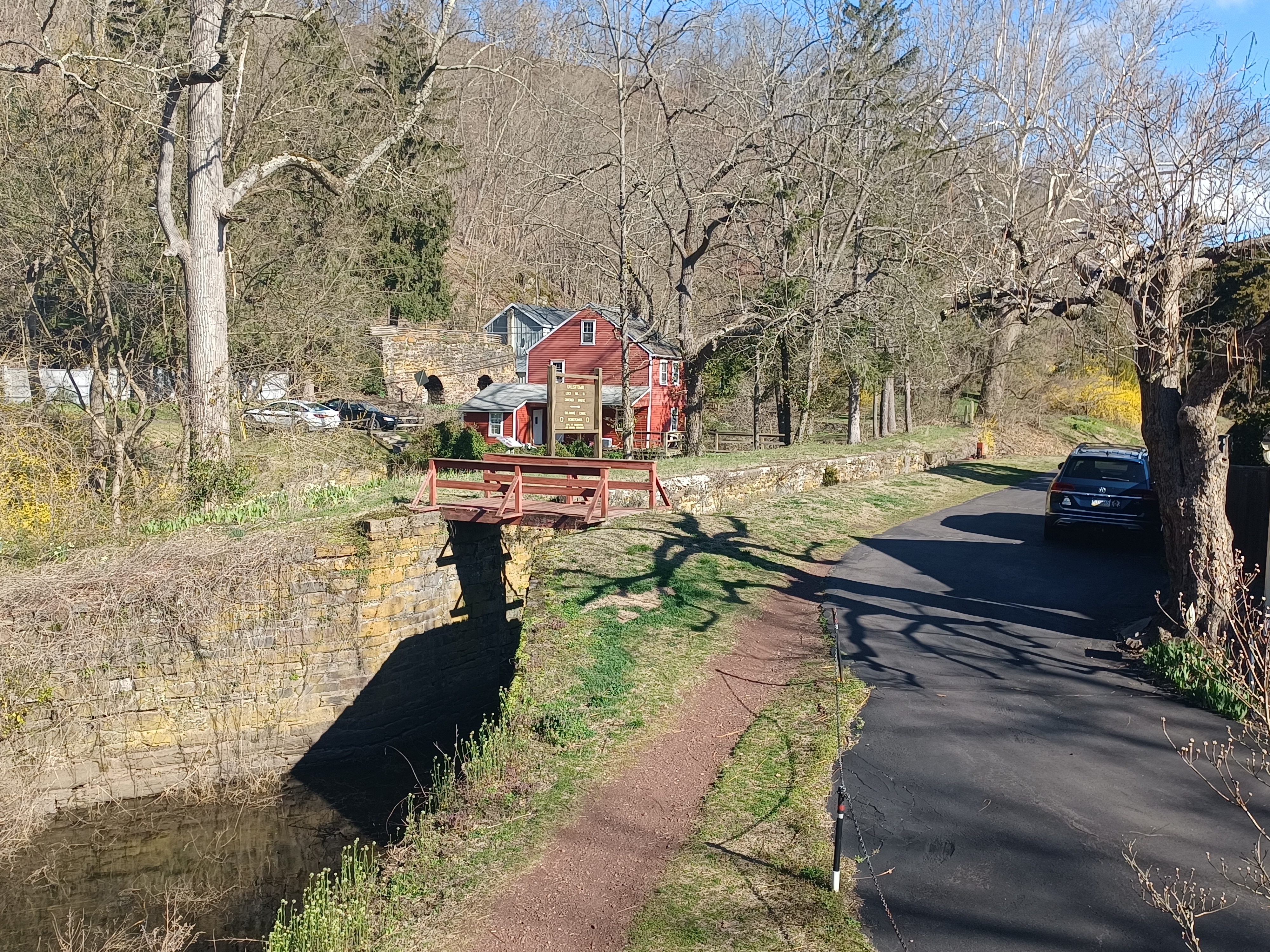
I also told everyone the interesting history of the Frenchtown-Uhlerstown Bridge over the Delaware.
The original Uhlerstown-Frenchtown Bridge was constructed in 1844, with long spans. It surprisingly lasted a good long time, sustaining only some damage in floods of the 1800s.

The bridge was not so lucky, however, with the Pumpkin Flood of October 1903, so named because pumpkins were flowing down the swollen Delaware River.

Two spans of the covered bridge were swept away in the flood, but the remaining ones were kept in service, and the missing spans were replaced with through iron trusses.
The bridge remained in service with four wooden spans, two metal, until it was dismantled and replaced with the current one in 1931.
I also had to stress to everyone that the trail here was NEVER a towpath, although people constantly refer to it as that.

There was never a canal in Frenchtown. The Delaware and Raritan Feeder Canal is along the Bel Del line as far as Bull's Island, but it never went any farther north from there.

The next town up, Milford, named the restaurant in the old railroad station "Canal House Station", which further adds to the misconception that there was a canal in the area.
The state park refers to it as the D&R Canal Trail, even though there was never the canal here.
We made our way onto the bridge walkway, with splendid views, and reached Route 32 in Pennsylvania, in Uhlerstown.
We turned left on 32 only very briefly, and then right on Uhlerstown Hill Road. This is a narrow road closed December through April of every year just beyond the Delaware Canal.


There were really nice views as we headed up this road to the west, toward the Uhlerstown Covered Bridge.

We continued to the mouth of the old covered bridge, painted a brilliant red. We walked through it and then back. Out the window, we had a good view of Lock 17 on the Delaware Canal.
There is an access to the towpath from a driveway right next to the bridge, pedestrian only.
When we got down to the canal, I had a then and now compilation to set up using an early 1900s image of the bridge.

The Delaware Canal, originally Pennsylvania Canal Delaware Division, was built in 1832.

When the state owned canals were given up on, I understand that the Lehigh Coal and Navigation system continued to operate the Delaware Canal, which made it the longest lived of America's towpath canals, abandoned in 1932, although a little piece of the Lehigh Canal was supposedly used briefly during World War II. The covered bridge here was also built in 1832.
Michael Uhler, a canal boat builder and first postmaster, came to Uhlerstown in 1853 and began his business. He expanded upon the small settlement, and when he became postmaster, the town name was changed Uhlerstown, in 1871.

Prior to this, the village name was actually Mexico.

We walked a little bit to the south on the canal, and we could see Conrad, Allie, and Nicole walking Uhlerstown Hill Road from the towpath looking back.
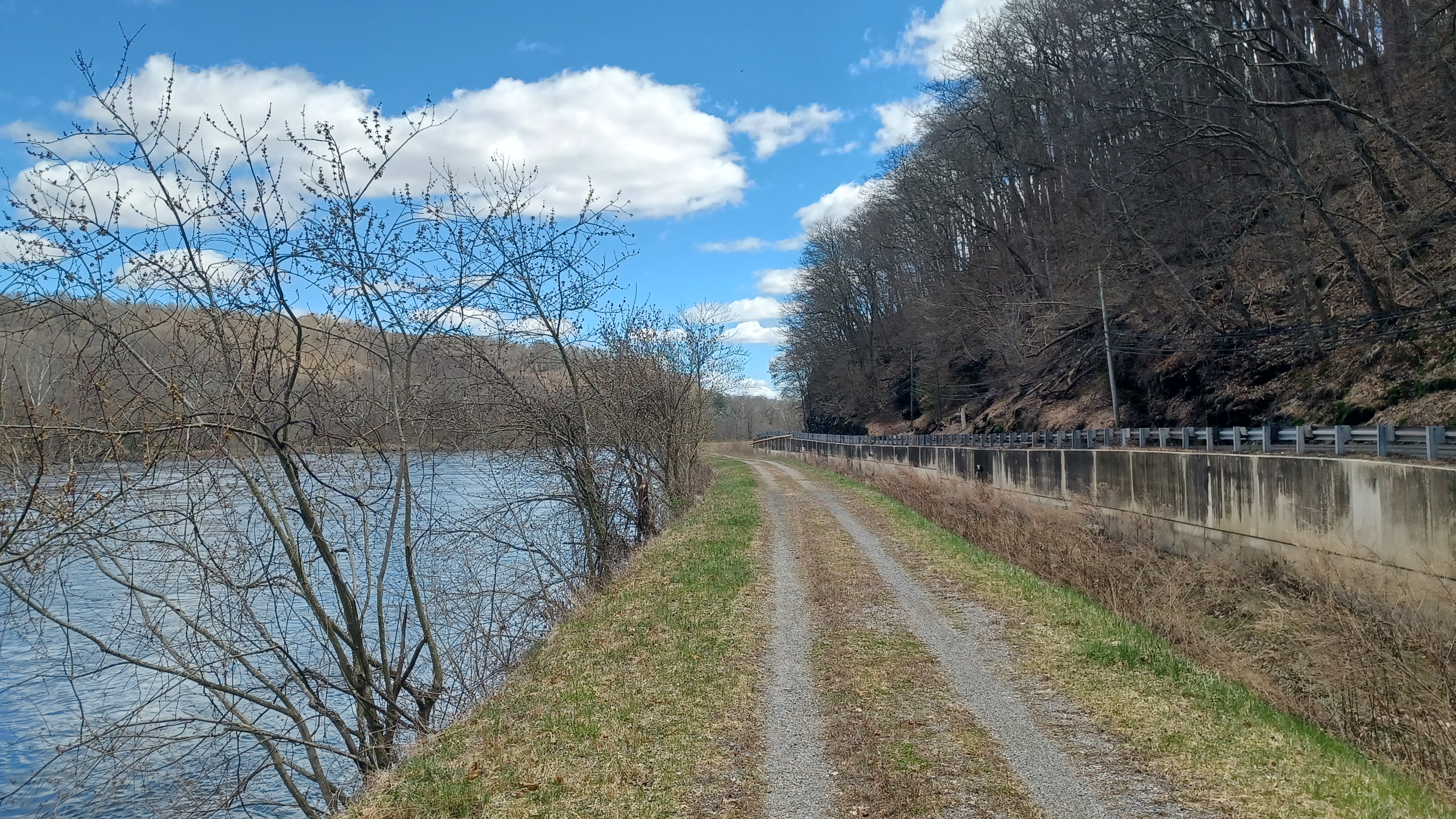
The section of the canal and towpath heading south from here is long and pleasant, far away from the Delaware River enough that it hasn't really been damaged from flooding so much. The flowers were all beginning to bloom, and the air was comfortable. Pretty soon, the canal skirts the western end of Tinicum Park, a huge green space.

We continued on ahead and eventually came to the little settlement of Erwinna, where we crossed Headquarters Road.

Erwinna is an unincorporated community of Tinicum Township named in honor of Colonel Arthur Erwin, who was leader of the Bucks County Militia.

It was said that Erwin was the supplier of many boats used by General George Washington and the Continental Army during the crossing of the Delaware on Christmas Day, 1776.
By the time we reached the road and took a little break, the group had pretty much all caught up.
We continued ahead through very pleasant wooded land to the south. There were some small cascades and streams that flowed from the steep slopes to our right and into the canal along the way.

The canal started getting closer to Rt 32/River Road, and then passed by the the Golden Pheasant Inn and former mule stable.

There had been a tavern and Inn on site starting in 1811, and amenity buildings were added when the Delaware Canal came through in 1832.
A massive fire in 1856 burned the original tavern, which had been known as Waterman's Inn.
The structure was rebuilt by owner James Leslie at that time. It has passed through several hands and remains popular establishment today.
Just past the tavern, there was a giant mule statue on the other side. I'm surprised that there are still so many of these all around.

This was part of a sort of fund raiser art project back in the early 2000s called "Miles of Mules", where painted and decorated mules were placed in every town along the way where mules were used, mostly canal towns.

I guess they went to auction, and different locations received them where they are still on display.

There was also a handsome, giant silver maple tree right by the mule.
We passed beneath Rt 32 and continued along the Delaware River closely heading south.
A little bit to the south, the rush of water was apparent well before we got to it. There was a weir, or spillway, where the canal was draining off. These were designed so that the canal could be drained for maintenance in sections rather than in long stretches.

This weir was conveniently located just before the Tinicum Aqueduct. I went down a path adjacent to it to have a closer look at the water runoff. It was a pleasant spot along the Delaware.

Just a little further south, we approached and crossed the Tinicum Creek Aqueduct.
The Delaware River moved off to the left a little bit from the canal in the section ahead, and on the left, down in the woods, was some sort of abandoned container building. I suppose this could have been the site of some sort of summer homes from the past, but they've long since flooded out.
Just ahead of this, there was a car sitting on its side down on another part of the shelf of land above the Delaware. I flood channel separated us from that area with a wetland.

We continued along the river to the south, and the access to this area that was probably some kind of Summer homes was likely a bridge that is long gone. We could see an abutment on the right as we approached the intersection with Dark Hollow Road across the canal from us.

On the corner of that road, there was a very old, abandoned house set into the corner. Just past that, there was another home that was lived in, who probably own that one on the corner.

The old house sits so close to the roadways, it's unlikely anyone will ever fix it up.
A little further ahead, two more dwellings were on the steep slopes along the river. The second one was a rather new looking cabin, but the first one was certainly much older.
It had a lower floor covered with stucco, but the second story was obviously masonry, but painted so it was not apparent at glance that it was so old. The original triangular roof peak was visible from the sides, but it had a newer third story added around it with wooden paneling.
This house was also vacant and boarded up, but was really cool looking.

We pushed ahead, and soon came to Lock #17, also known as the Treasure Island Lock.

The area is referred to as "Treasure Island" because of the adjacent scout camp properties that had been the second longest running scout camp in America, starting in 1913. It was closed after flooding in the early 2000s, and eventually sold in 2018. Today, Friends of Treasure Island operates the property and has opened it up to scouting uses as well.
The camp consisted of both Treasure Island and Marshall's Island.
The site has great significance among scouts, because it was the birthplace of the well-respected Order of the Arrow, which is among the challenging ordeals within scouting. It is a national camper's honor society based upon native American traditions.


The scouts used to perform their swimming trials in the lock back in watered days.

Today, I understand the Treasure Island Camp is cared for once again by Treasure Island Outfitters, who seem to occupy the building across from the lock, and they allow for Scouts to continue to use the property. I believe the house occupied here is the old lock house.
Some of the same washouts that caused major problems for the scout reservation also decimated the canal and towpath. While nearly completely watered up through 2004, a flood in September of that year destroyed sections, and the entire canal has never been fully watered since.


It is the subject of some frustration for me based on my own experiences. I sometimes don't like to go into this stuff, because the way the world has gone as of late, I just come across as a conspiracy theorist who's digging for such things.


The truth is, I've lived a lot of life and seen a lot of things, probably a lot more than average for someone my age, and simply being out there exposes one to a lot of injustice.

In this case, it wasn't some huge criminal conspiracy, but rather some foolish decisions made to placate a contingent of complainers.
In early 2004, I was setting up my hikes, in some ways with more planning and organization than I do today. I would travel to park offices, ask questions, arrange parking.
In doing so, I stopped in the Delaware Canal State Park office in Upper Black Eddy PA area. A lady was working the office, and I chatted with her about the canal towpath, and why it was ridiculously closed for such a long time.


It had been closed for a "resurfacing project". I'd seen some of it, just traveling along to wherever, or probably to visit my dad on Morgan Hill.

They had ground the towpath down to sub-level, placed some landscape fabric (the first time I had ever seen this used), and then placed a crushed stone surface on it. It made it all smooth gravel the entire way.
The lady at the park office said that this had been done because the DCNR, the state park's parent organization, had gotten so many constant complaints about the condition of the towpath being too bumpy to ride.


True, the towpath was very bumpy, but it was not designed to be a bike path. This was literally a built equestrian trail for walking and mules. These tree roots that had been growing through this man made berm for 170 years were literally holding it all together. They were the reason why the historic route had held up so well to floods in 1903 and 1955.

I told the lady that this was going to be a problem. They'd basically ground down their insurance policy on the canal to placate complainers.

It was that September we had a major flood, not quite as high as 1955, but close. Then we had more floods in that came up over the towpath over the next decade.
It hasn't been that we're having more than before, the damage is because the bones of the towpath are gone. It washed out at multiple places and remained closed to public for years. One of the most major pieces of greenway in eastern Pennsylvania was damaged beyond what could be repaired by any engineering other than nature.
Sixty miles of canal stretched from Easton to Bristol, and it was severed just below Easton, just below Riegelsville, at Lumberville, and I can't even remember what other spots.

We took a long break at the Treasure Island lock so I could set up sever then and now history compilations before moving on.

The lock was in excellent shape, with hardware still in place, and intact bypass flume for water.
We continued down from this point, and there was soon another abandoned house on the river side of the towpath. This was probably another flood insurance problem.
I let Ev out of the stroller to walk himself for a while. It was a pretty pleasant section.
Ahead, we came to Bridge 5. The Bridge 5 Lane goes from 32 to the left and down to some homes along the river between the canal.

This was a particularly beautiful spot, with lovely homes built into the slope along 32, and right by the bridge, a couple of waterfalls spilling down to the canal from behind them.

We continued ahead through this lovely little community known as Smithtown. It seemed like things would be fine as we walked through, but then we came to Bridge 4.
The canal was completely fenced off for construction. Honestly, I don't even see why. There was no sign saying that it was going to be closed again. Whoever walked that distance was just screwed to have to go back. But we weren't going to do that.
I looked at it later, and it was online that certain sections were closed, but it was ridiculous that there was nothing on the towpath to say so. Further, there was no safe route around. Rt 32 is not fit for pedestrians.

In order to make this work, I picked Ev up out of the stroller and walked him down into the mostly dry canal, through some muck. The guys in the group helped to take parts of the stroller with them. The top, the bags in it, and the main frame each went with someone around fences, and then up onto the road where there were sand bag dams.

It looked to me like it would have been easy to come up with a safe pedestrian way through, even if it were just to walk the bikes. By making this blockage, the state created a major liability.

After crossing over the road, there was another chain link fence right down to the water of the canal, which wasn't deep, on the other side. I was easily able to carry Ev down and swing around that with no problem.
We went ahead a little bit to get out of sight, and the others soon came through with the stroller. I thanked everyone for the great effort, and we moved on ahead.
There was nice scenery, and literally no one else out there. Steps led down from the road where houses used to be, but are long gone. The homes that were still in this area were beautifully manicured.
 |
| Forgotten Bridge 2 cemetery? |
Soon, we approached Bridge 3. Another problem. This time, there was fence right up to the thickets on the left, and although some of us could fit in and around that, the stroller wouldn't. We would have to make the effort to pass Ev around and then somehow hoist the stroller over top.

We managed to do this, and from the other side, there was a path where people were going around as I recall, to get back on the towpath on the other side.

Again, there was no warning about this closure, and it took a lot longer and more effort than we were anticipating.
I was thankful to be done with this frustrating section, and back on trail that was clear on the other side.
This second detour around fences basically had us miss Locks 15 and 16, the Smithtown Locks.
The residential roads ended along the Delaware (I don't know why foot traffic couldn't have been routed there), and we were along the river straight ahead for a while, and eventually came to Bridge 2, where there is a small parking area to the left.

I had everyone take a side trip with me here, over to the parking lot, because it was here that I found something cool on my own a few years ago.

One of the last times I walked this stretch of the canal was a day I took off work thanks to an invite.
Mutual friend Bob Barth, who has been synonymous with canals for so many years, and who's efforts I have followed, last minute invited me out on a hike with David Barber and his wife.
Bob Barth and I were talking about canals recently, and I'd discussed how much I appreciated the work of David Barber, because he had authored books on both the Lehigh Canal and Delaware and Hudson Canal. These books had been my companion hiking both of these entire routes.

Trying to find the remnants Mr. Barber found took very serious effort, which I greatly respected.

I am forever indebted to Bob for recognizing this appreciation and inviting me to join this hike with Mr. Barber. To me, this was meeting a celebrity.
I got to walk this stretch of the canal and chat with the man who was my guide on so many miles without having ever met him previously. Further, I talked with his wife, not having known that she accompanied him as well, and bushwhacked through all of that mess with him!
Mr. Barber signed both of my books, and I was very thankful. We shuttled our vehicles between points, going from Bridge 2 to maybe Virginia Forest, I can't quite remember.
I paused at this Bridge 2 lot, and ran back to the wood line to pee, and in doing so, I discovered a single grave stone on a knoll above the Delaware River.
To this day, I do not know who is buried there, or if it is the only burial. No one seems to have any record of it, but I wanted to share some of the above story with my friends, and show them the grave I discovered as the close of that day (I actually drove around and scouted more hikes after).

The rest of the group headed down along the Delaware, because they spotted some more ruins just barely below us.
It turns out this was probably a built in swimming pool along the Delaware, just a little below the grave and upstream a bit. A very strange spot.
Beyond Bridge 2, the canal was inland a bit more again, and we had a very pleasant walk through the section ahead.
We crossed beneath Bridge 1, and then the canal passed through the Walters Nursery and landscaping area. It was wide open and beautiful, although a bit hot.
Ev was getting tired, and fell asleep for a while on this easy going segment.
Pretty soon, we reached the Byram Road underpass in Point Pleasant.
This was an historic 1877 pony truss bridge over the canal. The road led to the Byram-Point Pleasant Bridge over the Delaware River that was washed out in the Flood of 1955.


The original bridge across the Delaware here was a covered structure built in 1855. It was replaced by a metal structure in 1892. That bridge was washed out in the Pumpkin Flood of 1903, and replaced by a steel structure that washed out in the flood of 1955. Only the piers to that bridge remain today.

After passing beneath this bridge, just ahead we reached the Tohickon Aqueduct, which carries the canal over the Tohickon Creek.

Some creeks were easy to make a culvert under the canal, or simply allow to flow into the canal as supplemental water source with a spillway, but the Tohickon was one of the largest creeks the canal had to cross.

The original trunk aqueduct over the creek was replaced in the 1940s to keep the canal watered. It was upgraded in handsome style with ornamental outside arch designs in the early 2000s.
I had another couple of then and now compilations to put together featuring the aqueduct, but one of them I couldn't get because it looked like I would have to go into someone's yard to do it, so I didn't bother.
Just a little bit beyond the aqueduct, we reached Lock 14. Locks 14 and 13 were also known as White's Locks.

Just before this first lock, the Hickory Creek flows into the canal, but recent flooding had blasted it in pretty badly. The canal was filled with all sorts of stone and debris.

A little bit beyond here, we passed by Lock 13, which is also in fine condition. The canal then gets a bit closer to the Delaware River again, and the slope along the right gets much steeper.
As we got nearer to Lumberville, Rt 32 started to ascend to the right. Diane warned us that there was another bad washout that we would definitely not be able to get around coming up ahead, so I started looking for an escape route to the road.
There was a spot where I figured we could probably get across the canal and up to Rt 32, but it wasn't going to be very easy. There also wasn't much of a shoulder.
We descended a bit into the canl where it was dry enough, and then climbed the other side. The group helped me to lift Ev's stroller up onto the road, and we started ascending.

Some of the others went ahead of me so that there was a buffer between Ev and the stroller and I. Some of the group didn't heed the warning and continued on the towpath to the south.
I suppose they figured it would be like the other spots and they'd be able to get through, but this was not the case.
We headed uphill and reached the little community of Lumberville. It's a nice place, with narrow streets and a lot of traffic on 32, but otherwise pleasant.

Pretty soon, we reached the bridge over the Paunnacussing Creek. To our left, we could see that the aqueduct that had carried the canal across this creek was completely gone. There was also no good way down either side and across. Unless they went all the way back, the only other choice would be to cut through someone's yard to get back out to Rt 32.

At this point, there wasn't enough room on the road to be worried much about it. We continued to move on ahead up the road, and soon reached the access to Lock 12, the Lumberville Lock.

I'd done loops from New Hope and Lambertville to this point so many times after Ev was born, just because it's an excellent loop. The lock is the only access up to the bridge over the Delaware just ahead.
The Raven Rock-Lumberville Foot Bridge over the Delaware River connects to Bulls Island on the NJ side. The suspension foot bridge was built by the Roebling company in 1947 on the site of the original 1856 structure, using the same piers.


The Pumpkin Flood of 1903 washed away one of the 5 spans, and so it that segment was replaced with a steel through truss in 1904.

The other 4 covered spans were deemed unsafe, and the bridge was condemned in 1944.
The original toll house still stands on the Pennsylvania side, and so we walked up from the lock to that point to take a break. Some of the group headed up the road to the Lumberville General Store to get some lunch, but the rest of us held back.
I had a few then and now compilations to set up in this area, so I did that first, while we waited for those going to the store as well as those who had gotten stuck behind.
One of the images was dated 1942, and featured a pontoon bridge next to the previous bridge. It is unclear why the Army Corps of Engineers erected a pontoon bridge across the river at this time, if it was two years prior to condemnation of the old bridge.
The others behind us all caught up, and then some of them also went to the store. When it started closing in on an hour since we had gotten there, I really wanted to continue on. It was going to be late getting back if we didn't get a move on.
I gave a call and they said they would be moving. Those of us who hung back walked across the foot bridge with great views of the Delaware, and then turned to the left on Bulls Island to visit the playground there. I should have gone over there earlier, because it was a better spot to wait for Ev. He still got plenty of time there, and is getting way better at climbing.


We hung out at this spot until the others eventually meandered back across the bridge and over to the playground. We also made use of the good restroom at Bulls Island Recreation Area.


This area used to be a campground until sadly a camper died when a large tree fell on him in his tent. The way water rises and falls along the river, it causes deeper root systems to die, and shallower root systems end up holding up a giant tree.

There's really no way around dealing with these types of trees in flood plains. It was decided that the campground would be shut down entirely because of this.

Shayna left the group soon after we started waiting because she didn't want to sit still for too long. She had not been out with us in a while, and stopping certainly does make one more sore.
We continued past the office building, onto the access road, and then headed out over the river channel that was once part of the northern end of the Delaware and Raritan Feeder Canal.
The main canal from Bordentown to Trenton then to New Brunswick opened in 1832. The Feeder Canal from Trenton north to Bulls Island, which is so named because apparently bulls were once kept here years ago, was bult in 1834.
The Feeder Canal supposedly served as just that for many years, and then it was upgraded with locks in about 1850 for navigation.

Looking down at the crossing of the old canal, I pointed out where gate pocket remnants are still visible in the remaining wall there.
On the other side, the parking lot for the rail trail was the former site of Raven Rock Station on the Bel Del line. The settlement was switched names to Raven Rock in 1890.
The original 1852 station was a rather large structure, which lasted until 1942, presumably taken down to recycle the wood during a lumber shortage of the time. This didn't end passenger service to the site, however. The station was replaced by a small shanty structure that served as the station shelter until about 1960.

Freight service continued through this area until 1978, and the rails were removed in 1980. It was changed to a state park trail some time shortly after that.

We turned and began walking the right of way to the north, and some of the Delaware and Raritan Canal to its northern terminus at the Delaware River was visible for just a bit.
Since the navigation on the canal didn't even start until the Bel Del line was under construction, it is logical to assume that the rail bed was actually never the towpath even where it is right beside the canal.
The rail bed is pretty much separate and farther away from the canal all the way from the northern terminus of it down to Brookville, south of Stockton.
We had a pleasant walk to the north, and passed soon through the forgotten small community of Saxtonville. I can only think of one building remaining from that settlement, the old Saxtonville Tavern. I pointed it out to everyone to the right as we went by.
The earliest portion of the stone structure is believed to have been constructed in 1810, with major additions on either side from 1820 and 1835. The tavern was most successful after the development of the canal and the railroad.
Soon, we crossed over the access to the Byram Boat Launch. I don't think we went down there this time.

Ahead of here, there was a small community to the left side, which is part of the little settlement of Byram. River Road paralleled the rail bed to the left for a bit.

We continued as the river bent, to the west, then the north. Near this bend, we reached the former east end of the Byram-Point Pleasant Bridge, across from where we had been before.
This was also once the site of Byram Station on the Bel Del line. Like the previous Raven Rock station, the original structure disappeared earlier on and was replaced by a shelter structure as I understand.
On the NJ side, one can get closer to and view the former bridge site better. Since the last time I'd hiked with anyone through here, the nearest pier out in the river had begun badly collapsing under the current of the river from recent floods.

Actually, the Bel Del line had some bad washouts through the section we were walking, but the guys at the state park got it cleared in pretty short order.

We continued pleasantly to the north for a ways, and Ev got down out of the stroller to walk a few times. Joe Millionaire was a good sport and let him ride on his shoulders for times.
When we came to near the intersection of Warsaw Road on parallel Rt 29, we were directly below the awesome rock formation known as the Devil's Tea Table.
I had been up to this feature a couple times, and found it to be incredible, but it is now very much off limits, and its future is very much in question.


The aesthetic of the rock face is expected to change pending an NJ DOT rockfall mitigation plan, similar to the boondoggle I've been trying to help fight at the Delaware Water Gap.

Residents claim there are no significant rockfall issues, including following recent earthquakes.
The NJDOT plan calls for scaling back rocks and removal of vegetation from the slopes. This vegetation includes naturally growing Prickly Pear cactus and many other habitats.
There is a trail up to the top of it, but it is covered in more "no trespassing" signs than one could possibly find most anywhere. Somewhat understandably, it is within a fall zone where if anyone threw a rock, it would absolutely hit a road and potentially a car.

The destination was once so popular that it was featured in the early editions of the New York Walk Book, a publication of the New York/New Jersey Trail Conference.

The early editions had all over NY and NJ, as it was intended for day trips from New York City. Eventually, the New York Walk Book was only NY, and the companion New Jersey Walk Book was treated as a second volume.
I hope his debacle is fought hard, and I'll definitely put my two cents in when it comes to all of it when it becomes necessary.
My first time up the Tea Table was during one of my hikes in October of 2003. I can't believe it's been over 20 years since then.
We continued north through Kingwood Township for a while more, and stopped to look at underpasses and a pair of stairs coming down from Rt 29 to the rail bed.
I had one more then and now compilation to set up, this time using an early 1900s postcard image of the Kingwood Station stop.
The station was a shelter building located near the intersection with Kingwood Station Road just off to the right, off of Rt 29.

We had a little break at that location, the last one really for the day, and then continued strolling pleasantly back to Frenchtown to the north.

As we got closer to the end, everyone in the group started powering way ahead of me. Jenny, Kirk, and Justin passed Shayna on the way, and were sitting in a chair in Frenchtown when she then passed them again.
I eventually wandered on in, happy to be done. We'd definitely hit over twenty miles, but it was a very nice time.
I loaded Ev and the stroller up, and we were on our way home soon.
As I was coming up on Washington, I got a call from Shayna. She was asking me how much farther the cars could be!
I knew right away that she had passed the cars and continued to the north, but fortunately, the trail doesn't go on too far north, as it doesn't connect to Milford yet, but she definitely was too far.
I stayed on the phone with her until she was back in more lit area and around recognizable landmarks on the north of Frenchtown, and made she she knew what to look for when approaching where our cars were parked. I also reassured her that, at the start, she wasn't sure if she could still do this, and she went from being not sure to covering at least 25 miles!
Aside from these little hiccups, this was a really great day for our 1600th hike.