

Hike 1586: 1/7/24 South Harrisburg Loop with Jenny Tull, Diane Reider, James Kohan, Dan Asnis, Peter Fleszar, and Everen

This next hike would be a big loop in the Harrisburg area, a return to some of the Capital Area Greenbelt.
For the start of the year, I planned out several different hikes with alternate versions to do just in case of inclement weather. For this one, I did have some other stuff I'd wanted to do, but I changed it up to simpler stuff because of the potential for snow coverage.
Two major contributing factors for planning this hike on this weekend were the Harrisburg Mall and the State Farm Show.

I had attended the State Farm Show in Harrisburg a couple of times before, and it was always interesting, so I figured I would have a hike go through it.
More significant was that the Harrisburg Mall was soon to be demolished. I found out we had maybe a month or even less left until the place would be no more. A couple of segments would remain open as separate stores, but the entire inside section would soon disappear. I had to see it before it was gone.

I planned for the hike to meet literally at the mall itself. I then planned for our route to hit several locations, some of them I'd done, some of them I had not.
My plan was that the hike would conclude with mileage inside the Harrisburg Mall, but we'd do the Capital Area Greenbelt Trail and connections for the remainder of it. We wouldn't go into the mall at first, but rather photograph it from the outside on the first go.
As we arrived, it was cool to see old friend Dan "Doggie" MacMahon showed up to say hello to us! He had recently moved to the area of Carlisle from New Jersey, and since we were close, even though he wasn't going to hike with us, he'd stopped to say hello.

After our greetings, we started moving on along the front of the mall past the signs and store fronts.


We continued to the north through the lot, and there was a large excavator sitting, waiting, and looking poised for destruction. I'm not sure if it was part of the planned demolition of the mall, but it definitely had an ominous look about it.

We continued west through the lot, got some good views of the mall, and then reached the end of the lot. I had Ev in the stroller, and there was a good amount of snow on the ground. I was fearful of how bad this might be, pushing against all of that.

Fortunately, Harrisburg was not as bad as the snow we had gotten back home, which seems weird because it is so much farther into Pennsylania.
Still, I had a bit of a tough time. There was a good amount of snow, not enough to really be terrible, but enough that it was not so easy to push against. I certainly got a good workout for the day.
Out of the mall lot, we headed downhill through snow to Paxton Street. The road at the start of this heading west was one of the worst parts of the entire hike, but we got through it.

Soon, we reached where the Capital Area Greenbelt crosses over the road.

The Capital Area Greenbelt is about twenty miles long, encircling Harrisburg with the inclusion of several different historic park components constructed between 1902 and 1917. Susquehanna Riverfront properties were developed with walkways and steps, Wildwood Lake was developed utilizing some of the old Pennsylvania Canal, the Paxtang Parkway and Cameron Parkway were both linear routes created.
After World War I, the greenbelt plan stagnated and interest was lost. World War II brought a new influx of people that didn't care so much for city parks.

The entire system was pretty much abandoned, and the linear bits were gated and closed off.

It was even proposed that a McDonalds be built over part of the completed greenbelt, which led to a whole lot of opposition. Volunteers led the charge to restore the existing completed bits of Greenbelt, and funds were raised to connect and essentially complete the sections of it.
Today, a marked through route is in place, and it's really a pretty fantastic urban trail.
I first found out about this one several years ago, and ended up hiking it around the time of my first visit to the State Farm show. I had only done the south half of it, on a route that was a variation of what we were doing this time.

A few years back, I planned out and did another hike that involved the north bit of it that I'd not done before.

The only bit I haven't really done at this point is the segment that goes farther through Wildwood Lake Park, but I'll get to that one eventually.
We began following it to the south, on the wide former road route.
The Spring Creek was just beside us to the left. The snow was not deep, but it was hard to push the stroller through, and the wheels didn't always want to cooperate with me when trying to turn. The workout for me was much more than I am used to.

There were those sections of darker surface snow, which was the tell that there was standing water beneath the snow. I wore shoes that were not waterproof, and I of course got my feet soaked.

I'd been wearing these nice red sneakers that Jillane had got me at a thrift store or something a while back, and they were holding up way longer than I'd have expected they would. They were a bit small on me, so this time the cold water actually helped to make it feel better.
We continued south around curves on this greenway, and crossed over Rt 441; Harrisburg Street/28th Street. At the crossing, there was a little sort of art park just to the left in a sort of cove from the greenbelt. I remember stopping for a break here with Jillane the first time I ever walked any of this greenbelt years ago.

Along this next stretch we passed a new Martin Luther King Jr memorial. It was just before his birthday (January 15th 1929, and the observed holiday actually fell on his birthday this year).

We reached 19th Street, and the trail went beneath it. It was a pleasant walk, but it was kind of tough because the stroller wheels would kind of kick out a bit as I had to make turns. I tried to stay in some existing tracks from bikes and such to make the job easier.
We weaved around a lot along a nice stretch of the creek heading south, and I pointed out to the group how there are strange bits of graffiti all over this trail.
Each one of the paintings is pretty much an old eight bit or earlier video game. There are Super Mario Bros, Pac Man, the ghosts from Pac Man, alligators that I think are from Frogger, mushrooms, fire flowers from Mario, and more.

There are also often mountain biking trails parallel with the main trail that just deviate slightly. Part of my original plan was to try to follow the mountain biking paths, but the snow kept us from that.
Soon, we came to Rt 230, Cameron Street. The trail crossed here at a crosswalk, and then turned to the right.
Shortly, we crossed Elliot Street and continued a bit to the northwest.
This was an interesting section; I had walked this before and I don't think I'd given it a whole lot of thought on what we were walking. I just knew tha it was some sort of railroad bed.

The path went through a sort of cut ahead, and crossed an access road where I remember rails were visible.

I didn't put two and two together before I don't think, that this was actually the historic route of the Pennsylvania Canal.
I knew about where the canal went, but this part slipped my mind because I'd done it earlier. This was part of the Main Line of Public Works, the combination canal and rail route that connected Philadelphia with Pittsburg completed in 1834. I believe this section of canal was completed in 1832.
The Pennsylvania Railroad purchased most of the Main Line of Public Works, and operated some sections of the canal for a time, but then closed it. This section became part of the railroad system sime time around 1901.

We continued on the trail for a little ways ahead, and soon approached a through truss bridge that spans the trail. This bridge was originally built to carry the railroad over the canal, and there was an aqueduct that carried it over the Paxton Creek. At least it looks to me like it was an aqueduct, but it might have been a weird. I can't be sure.


On the other side of the bridge underpass, there was an informal path and steps that went up to the left, that looked as though it would cut a corner in the greenbelt, but I wanted to stay with it the correct way.
We continued on ahead, and there was a sign reading that the Capital Area Greenbelt was closed just ahead, and the detour was to the right.


The trail was closed and fenced off at the bridge at this point, but we didn't know why at first. I found out later that the city was full of homeless veterans that used to be camped out just to the north near the Interstate 83 bridge. The city has been working on some sort of plan to provide them with shelters, like old containers or something. While work is going on, the trail is closed here. It might remain closed forever if this goes in.

It was kind of sad, because there was one small loop of the Capital Area Greenbelt on the other side of that bridge that I had not done yet. I figured we would do it this time, but that didn't work out.

We had to backtrack a lot. I wasn't too happy about it. I considered that maybe we'd dash across the active railroad tracks and try to climb the slope up to the large building on the other side, which was not very easy looking. I decided against it.
When we got to where the informal trail cut the big corner, I decided Ev and I would walk that back to the through truss bridge, and then continue on our way from there.
We followed the trail and carefully climbed back down to the main trail route on the old canal. We turned left, north, where we had been before, and then to the right when we got to a little shed building.

I had been in this before, but it was in better shape. It looked like someone had vandalized it, and it was not in regular use officially. Someone moved a plush type of recliner into it.

The small building I think was used as a trail concession, and sat at the 901 Lounge at Lochiel Hotel, a lovely historic building that had until recently been a part of the Capital greenbelt.
The building was initially built as a school house in the 1800s, along Shanois Street and sandwiched between the Pennsylvania Canal and the Steelton Branch of the Philadelphia and Reading Railroad. In 1901, it was one of many local landholdings of Jason McCormick, as per the local county atlas maps.
It served many purposes over the years and was recently restored. It was not open when we went by.

Ev and I hunt out in the little shack that went along with this historic building, and no one was showing up. I think they sort of waited wondering if I was coming back. No one followed me!

I let them know where to go to find me, and soon we were all back together again.
We continued along Shanois Street and under the railroad tracks, then turned left on Cameron Street again. The tracks were sat on top of an impressive cut stone elevated structure through this area close to the old school and hotel.
We continued ahead to a left turn on Sycamore Street on the currently signed Capital Greenbelt route. On the corner at this intersection was the beautiful, historic Church of the Pentecost.

The first cornerstone for this lovely church was laid in 1887. It was originally the Calvary Presbyterian Chapel, designed by the architectural firm of Smith and Warner.

We continued west from here, first under a bridge beneath the Reading Steelton Branch, and then up a bit of a ramp to cross the main tracks of the former Pennsylvania Railroad.

Just before getting to the height of the crossing, we crossed the former Pennsylvania Canal again. To the north, it was totally unrecognizable. There was no prism, no towpath, and all the land around it was disturbed. To the south, however, in some brush, it looked as though some of the shape of the canal was still there.

The Pennsylvania Railroad looked kind of odd. The right of way was probably at least 7 or maybe even 8 tracks wide, but there were three sets of tracks in it. It looked like the last two were gauntleted, but I'm not sure what was going on with it. Very strange looking either way.

Once across, we passed by a large building known as "The Roc". I had never heard this term before, but Jim explained that it was the headquarters of the Pennsylvania Department of Transportation. "ROC" reportedly stands for "Riverfront Office Complex".

Just past this, at the intersection with Front Street, we reached the Capital Area Greenbelt again. It didn't look closed to the left, but I am certain it must have been a short distance away. Phoenix Park is out that way, which had the loop I'd wanted to do, but that is where they are supposedly building the homeless shelters.

We turned right, and in a short while, passed beneath the Interstate 83 bridge. Many homeless people were still encamped in the area of woods around the bridge.

The bridge is officially called the John Harris Memorial Bridge, and it sits parallel with the Dock Street Dam over the river.

The original lanes of the bridge opened in 1960.
It was widened in 1982 and 2015. Plans for replacement in 2020 have been shelved.
We passed beneath the bridge, and the walkway took on two separate routes. One was up along Front Street, with a nice path, and the other was right down along the Susquehanna River directly, which would be of course the chosen route.

However, it was still quite slippery, and there are no guard rails on the section. I would have to hold on tight and be extremely careful with Ev as not to allow him to roll off into the river while I took a photo or something, since it was so slippery. I held onto him tight the entire time and used my brakes if I had to stop and everything was okay.
The biggest drag about this section was the wind. It was a cold day, and I had Ev bundled up in his orange snow suit to keep warm. This provides a good amount of cover, but he got pretty angry through this section, probably because he was cold and he didn't want to pull his hands into his sleeves.

After a bit of a fit on the waterfront, he laid on his side in an odd way and finally took his nap. I made sure he was kept covered over with his hood up, and things were okay.

Beyond the 83 bridge and dam, we could see the amazing Philadelphia and Reading Railroad over the Susquehanna.
The earlier bridge here was constructed in 1891, and the current structure encases some of the old masonry piers from the former truss bridge. The current bridge was constructed bit by bit from 1920-24 one track at a time by replacing trusses with concrete arches. There are a total of fifty one arches.
As we were walking approaching the bridge, a freight train began moving across it from east to west. I seem to recall Ev got to see me of that crossing before he fell asleep.

We continued ahead and passed beneath the lovely arch bridge, with some splendid views. On the other side, the next bridge up was the former Cumberland Valley Railroad Bridge.

The bridge was constructed in 1916 to replace an open Iron truss bridge that had been built in 1887. This replaced two old covered bridges on the site built in 1839 and 1846.
I've heard that the east side of this bridge has some track to it now, to connect with an existing line as a sort of wye. There are catenaries on the thing today, and maybe it'll see future use again at some point.
We continued from here, and the next bridge up is the Market Street Bridge.

This is the oldest extant bridge over the Susquehanna River in Harrisburg, built in 1905. Of course, the Walnut Street Bridge, the next one up, is a bit older, but it is no longer extant.

Walnut Street Bridge spans to City Island, then continued across from there to Lemoyne.
The through truss style bridge was constructed in 1890, and closed to retailer traffic in 1972 after Hurricane Agnes.
Sadly, some spans on the west side washed out and crumbled under the Market Street Bridge in 1996 during a major flood. I think about three of the spans were lost.
In incorporated the bridge and City Island into one of my previous Harrisburg hikes, so we didn't bother to climb up to it this time. We continued on the walkway heading upstream along the Susquehanna.

I watched the graffiti on the walls as we walked. The The Capital Area Greenbelt around Harrisburg is full of statements, like down in the Paxtang, there is one with links painted about weird final solution stuff. It's been there for years, but now they've added stuff about covid.

On this stretch, there was one that read "the cost of living is killing us".
Is the cost of living killing us?

It's an interesting question, based on personal experiences, with similarities and differences.
On one hand, Arizona Iced Tea had been 99 Cents for over 25 years. The McChicken was only a dollar for over 20 years. The same is true of many consumables we could use to cheaply survive.
On the other hand, 25 years ago I paid $400 a month rent in Phillipsburg. Now, paying $1,180 a month, and that being considered extremely cheap, we just scrape by.
For some, especially in retail and such, the increase in minimum wage has been a great benefit. However, for many there has been no cost of living increases at all. Government employees had no substantial increases, to the point that full time, permanent employees with multiple certifications were bringing home $14.80 an hour, while seasonal full timers, 16 year old with no experience or even a driver's license got $15.

Cost of vehicles has skyrocketed, as has the cost of of parts and labor.

My catalytic converter went bad over the past year, and even before getting a new one installed, someone cut it open to try to steal it (and was disappointed to not find one).
While many of us are not terribly uncomfortable, our new post-covid culture has widened the rift between the rich and the poor.
The high-end executives, down to office workers are often afforded the convenience of working from home all or part of the time. This substantially lowers travel cost, not only in fuel and wear and tear, but also insurance, as personal commuters are low enough miles to be "pleasure vehicles", which require negligible insurance.

Lower income individuals and families, without the convenience of remote working must continue to incur the costs of travel.
In addition, these difficulties breed added and undeserved animosity and prejudice. Programs that were always viewed as positive are judged as unfair.
When we walk through areas like this and see firsthand the struggle people are facing, it really puts into perspective how much worse it could be.
My home has no television service, streaming service, or even internet (except the phone), but I am still happy and living a great life. The folks living in tents on these freezing days along the trail have it rough.

The answer isn't just in rehabilitating the poor, or further taxing the rich. The answer is to target the people who exploit. The rich who exploit people and programs for their gain, the lower income who work the system wrongfully damage the reputation of social programs. And of course, the politicians on both sides who exploit the system and public for their sweetheart deals and emotional reactions.
The wind picked up quite a bit, and it was kind of brutal even for me. I was glad Ev was taking his nap through much of this section, although he started waking up just before we reached the end of the riverfront section.

Pete had been looking for us to meet up in this area. He thought we were up on the roadside section of the trail rather than down by the river, so he walked right past us and was to the south.
My plan was to climb up and cut to the east at Maclay Street near the Pennsylvania Governors Mansion. The walkway down directly on the river ends at that point anyway.
I looked at the time, and I wanted to make it to the farm show by about 1 pm when Mike Piersa was to speak about historic pumping engines, representing the National Musuem of Industrial History.

In order to make it, some of the other extra stuff I had been considering doing would have to be cut out. It was for the best, because we'd end up going over the mileage anyway.

Pete joined us where we turned onto Maclay. He was still catching up from having missed us before, but he was not far off. He caught up pretty quickly, and we all continued down the street ahead.
The walk along Maclay was pleasant enough, and it had some interesting points along the way.
One of them was an historic marker denoting the site of Camp Curtin, which was the largest enlistment camp during the Civil War, with over 300,000 enlistments passing through.

The site had been the Dauphin County Agricultural Society, and was commandeered by Pennsylvania Governor Curtin and renamed Camp Union. It was soon renamed Camp Curtin.

The camp also served as a Confederate Prisoner of War camp. The camp was torn down after the war in 1865, and absorbed into the new urbanization of the Harrisburg area.
Just ahead, we happened upon a pay phone, which is an odd thing to see these days. We went over to it to check if it was an actual working one, but it was not.
We continued east a bit more and soon approached the State Farm show complex, a really interesting looking, expansive building.
People were walking all along the streets as we approached the place more than what we'd seen before.
The Pennsylvania State Farm Complex and Expo Center was mostly completed between 1931 and 1939. The Capital Area Greenbelt goes right through the property, so it was convenient in that we could resume walking it right from the show.
We entered the building on the west side. I was at first concerned about all sorts of crazy security, but I was able to just keep drinking my drinks meandering through and no one said anything.

It was really incredibly crowded, but we were able to push on through and check out a few displays.
I wanted to try to figure out where Mike Piersa was speaking rather quickly. We were just about right on time for that, but had to navigate through the site.
We wouldn't be able to stay at it for the duration, but I wanted to stop for a bit. We made our way around the first room, in a clockwise fashion, then cut into the next area with the animals. Ev was still pretty big into cows, and so we saw several cows for him to look at.

We continued from the animal area to a larger rear area, and had to go up and down some steps or escalators, then came to an open area with lots of equipment. I took Ev out and let him sit on tractors.

Pretty soon, we found where Mike was speaking because we could hear his voice over the speakers from a distance. We approached and sat, and he was showing some images of the work they'd done at the museum, and how the large pumping engines worked.
He was having some trouble with the presentation, and the group was able to help him get it squared away so it worked better as well, so that was cool.
We hung out for just a bit, but eventually had to move on because I realized the time. The Harrisburg Mall was closing soon, and we had to get there so we had the time to walk through. Otherwise, I'd have to plan another trip to come back before they tore it down.
We made our way through the complex and looked around at food as we passed a bit. I was getting a bit hungry, but I didn't want to wait around for anything really, so I recall we just sort of pushed on through.

We came out of the building near Cameron Street, and turned to the right along the edge of the building. Soon, we reached the signs for the Capital Area Greenbelt, which descended and passed beneath Cameron Street by way of a pedestrian tunnel.

We emerged on the other side, and turned to the right along a softball field and paralleled Cameron Street just a bit. There was a seemingly abandoned white house just ahead, which I understand is part of the former Pennsylvania State Hospital grounds.
We crossed over an access road known as Circle Drive, and then paralleled rather closely a road known as Sycamore Drive.
The last two times I hiked through this area, Sycamore Drive was still fully open to traffic. Now, it is closed off to traffic, which makes it more pleasant I suppose, but probably makes a commuter issue.
The trail was a delineated paved or crushed stone path, which closely paralleled the road and the stream known as Asylum Run on the right.
This was all through the former grounds of the hospital.
The site was originally known as the Harrisburg State Lunatic Hospital and Union Asylum for the Insane when it was developed in 1845.
The hospital came as a result of social reformer Dorothea Dix, who completely changed the care of mental illness in America. Prior to her work, methods such as a rotating chair and drilling holes in the heads of patients to relieve pressure was still considered commonplace.

After suffering mental break-down herself, she found inspiration in other social workers and reformers and her life changed direction.
Dix authored several books, made strides in improvement of medical treatment, and served as the Superintendent of nurses during the Civil War. Her successful lobbying efforts helped to create many hospitals including the Harrisburg facility. The hospital began accepting patients in 1851. The main building and layout, completed that year, was in the Kirkbride Plan style, which was the popular building style of the time.
The name was changed to Harrisburg State Hospital in 1921. Continued improvement and medications eventually led to a major fall in patient population, and eventually deinstitutionalization. The state hospital closed down in 2006, but today is home to various government offices and much is vacant.
Jim was telling us that he once worked at the facility as I recall. He had explored around the site a bit, so this was cool for him to be hiking through some stomping grounds.

We continued along the pathway beside Asylum Run to the intersection between Pine Drive and Sycamore Drive.

A branch of the greenbelt continues to follow Asylum Run, and I've done that a couple of times before, but this time we stayed on the main trail, which turns to the right on Pine Drive.
This changed names to Stanley Road ahead, and the climb was rather steep on the road up from the old hospital grounds.
I pushed Ev's stroller in the road more of this because it was a hard push up, and the actual trail beside the road was not plowed off the way the road was.
This road section was open to some traffic one way, while the sections below were closed. Still, there were tire tracks around bollards and such where cars had still been going around.

We crossed through an intersections and continued on Stanley to the east, and there was an abandoned annex building to the hospital on our left.
I had seen this before, and was rather surprised it was still standing. Honestly, the fact that any of the facility is still standing, the way things like this go, is rather amazing.
My intention for this hike had also been to walk more of these hospital grounds to see some of the architecture, but the snow was just too tough to go through, so I had to simplify it.
The trail continued out beyond the end of Stanley Street, and then emerged into the north side of the East Harrisburg Cemetery. We continued through part of this, and then I cut a corner of the trail across the grounds.

My intention on this hike was to follow more of the cemetery as well, because I'd already followed the greenbelt route, but again it was much harder to follow that, so we chose to stick with the trail again here.

I'll have to do another entire hike featuring these alternate routes I'd envisioned in the future.
The trail took us right on Edgemont Road at the end of the cemetery, and continued to the south for a bit. We then continued up Parkway Drive after crossing State Street.
Soon, we reached the entrance to Reservoir Park. There are trails through this, but it seems that the trail actually follows National Civil War Museum Drive.
The museum here is another of the things I want to include on one of the hikes, but there just isn't enough time to cram it into one day.

The upper part of the park affords excellent views of Harrisburg, and all the way to the Dauphin Narrows to the north. The museum up there is the largest dedicated to the American Civil War in existence.

We had a nice walk on this bit because there was no snow on it, and because the section is only one way traffic, so it was mostly like walking a trail section.
We continued to the east side of the park, and then exited at Parkway Boulevard.
This is an interesting little section of town, because it is lined with post-World War II starter homes with slightly varying but charming brick facades. It's like a little forties time capsule neighborhood.

We continued east to the crossing of Cameron Street Road, and entered the Cameron Parkway section of the greenbelt into the woods.

Pretty soon, we passed one of those cell towers that look like pine trees, which we jokingly refer to as "Verizon Pines". I looked back at this and several other photos from my different trips out this way, and I have gotten the same photo sometimes a decade apart. It was an interesting study to see how the Eastern Red Cedar next to the Verizon Pine continues to grow up catches up with its competitor.
We turned to the south, into the Paxtang area, and I had a look at some of the little side trails that I had originally considered using for this hike.

Of course, they were way too snowy to be following this time, but the routes were intriguing.

We continued to the south, through Paxtang Commons Park, and then emerged at Derry Street.
The trail turned left on the road for a little while.
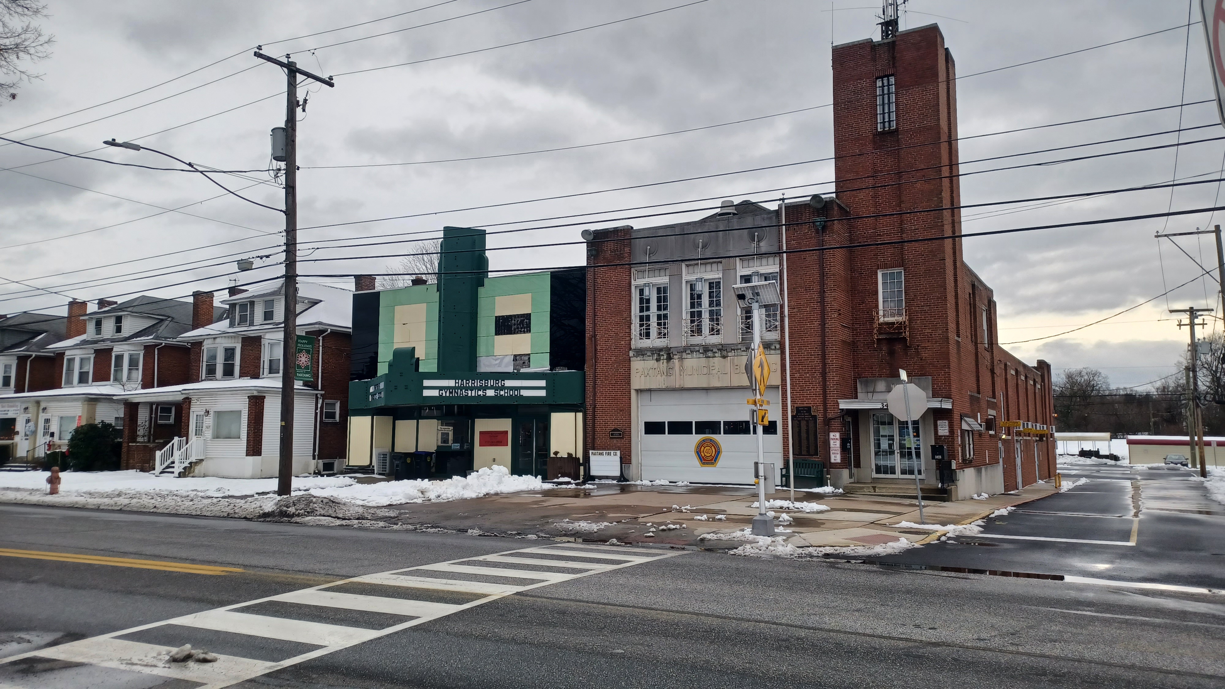
On the right side of the road, there was the old theater and municipal building.
Paxtang Theater opened in 1937 with 500 seats. It remained a theater until 1974; the last movie it showed was "American Graffiti". It was taken over by a gymnastics school, and it still uses the old theater area for that today. The Paxtang municipal building and fire house is next door.

The trail follows Derry Street for four or five blocks to the east, and then turns right on Paxtang Avenue. It dips down steeply between high walls and passes beneath the former Reading Railroad.

After passing beneath the underpass, which had inspirational sayings and art painted along, we turned right on a trail across an odd secured bridge over part of Spring Creek.
To the right, there was an old stone spring house structure along the stream.
The work was reportedly that of the late Carl Lorence, who passed in 2020.
I think I may have met this man years ago at the Pennsylvania State Farm Show. One of my first times attending, I spent a good long while talking to a gentleman supporting the greenway, and I think it must have been him.


At Paxton Street, we simply turned to the left and headed back uphill toward the mall building.

Rather than deal with the crummy slope we came down a bit earlier in the day, where I nearly slipped, we just walked the access road in to the mall area to the right.
We headed up into the parking area, still with plenty of time, and started photographing the mall from the outside. Jim went up on a giant pile of snow to get better angles.
The big anchor store on the end was already closed for some time, and we went by to the nearest entranceway to the building.


Dan Asnis had fallen behind us at some point on the greenway in the snow, but I was in touch and he knew where he was going.

The rest of us headed into this open area with a fountain and palm trees, where both levels of the mall were clearly visible.
Just beyond these fountains was a wonderful kids play area dubbed "enchanted forest". I wasted no time getting Ev out of the stroller and stripped of a couple of heavy layers so he could run around.
Ev had a look at the enclosed play area, where there were lots of other kids playing, but he had much more interest in some of these electric ride on things that were nearby, closer to the fountain.


There was an airplane, car, truck, ice cream truck, and I don't recall what else. He wanted to keep playing, and Jenny paid for one of the riding things to go for him.

When he did go into the kids play area, which had paths and designs of land and water, a fake boat, smiling trees, a snake, and more, he just couldn't stay interested.
There was a very friendly little girl, I forget her name, who took to Ev pretty quickly. She helped him to take his one jacket off, and was trying to show him how to play on the toys in there.
When Ev tried to run off and leave the kids area to go back to the riding things, she ran out and grabbed him, turned him back around, and walked him back in!


This happened a couple of times, and Ev didn't know what to do! He was a hilarious interaction to watch.

Eventually, we decided we needed to move around through the mall before it closes.
I think we took the elevator up to the top elevator of the all, and looked down on everything.
The aesthetic was really nice, and the kids play area, with the amount of people there, makes it really sad that it would soon be gone.
Once on the top floor, we walked the length of the place from up there. There were stores open, all of them with closing sale signs and 50% off and such.

One place, I think 2nd and Charles it was called, I understand is going to stay a bit longer because they had a lease that ended later than some of the others.

Ev was happy to be down out of the stroller and running around like crazy. We found a round area that would have had an entrance it seems to one of the anchor stores, and there was the entire food court with tables, but all of the store fronts closed off.

We went to the far end of the place, and then back to the end where we first came in to head back down to the lower level.

We proceeded to walk that level, and we did a nice group shot at a beautiful little fountain area with a waterfall and taxidermy that included deer, bear, Elk, and more.
We wandered around a little bit more, and just as we were getting ready to leave the mall area, Dan came wandering through the door where we had first entered. He was only maybe a half an hour to 45 minutes behind us.
We re-did another group shot with Dan in it, and we continued out the side door, and then into Outdoor World just around the corner. The inside access from the mall had already been closed off to this store, because that section of the building is going to stay when demolition of the other part begins.

The place was really busy with displays and quite a sight to behold. There was an enormous indoor waterfall straight ahead through the door, big stairs, a fish tank, and more.

I understand that the taxidermy and displays that we saw in the mall also belong to Outdoor World and that they would be re-claiming them when the mall was to be demolished. They also had had some birds hanging from the ceiling in the section close to where their access was.
Ev ran up the stairs by the waterfall and saw all of the fish. He was up and down stairs and running like mad every direction he could go. I followed him to the right through the store, and then to the left, all the way to the rear where there were boats on display inside. There was so much stimuli in this place, it's no wonder he loved it.

Eventually he got a bit more tired out and we sat down on some of the chairs in the front of the place.

Outdoor World is owned by Bass Pro Shops, the same entity that owns the famous Cabela's store in Hamburg.
We spent a good while in the place because it was just so interesting to see. Usually Jenny has extra energy at the end, but this time she was sitting in the chairs at the front as well.
We headed out of the place and back to our cars at the far side of the lot, with a last view of the Harrisburg Mall and denoting sign. Demolition began on the mall in early March.
St John Properties, who own the mall site, plan on a mixed use office complex, residential, medical, restaurant, bank, and more on the property that is to be dubbed the "Swatara Exchange".
After a time, we'll have to return to Harrisburg to check out more of the development of the site, and to revisit some of the route I had originally intended for this trip. There's still so much more to see, so many museums and historic sites worth visiting, we are definitely far from doing everything worth doing in the Harrisburg area.
No comments:
Post a Comment