Hike #1584: 12/23/23 NYC Manhattan and Bronx with Evan "Joe Millionaire" Van Rossum, Eric Pace, Jim "Mr. Buckett" Mathews, Diane Reider, Kat Cataldo, Justin Gurbisz, Jack Lowry, Sarah Jones, Mike Kresjea, Violet Chen, Brittany Weider, Jenny Tull, Shane Blische, Dan Asnis, Anne M, Jessica M Collins, Alyssa Lidman, Steve Sanbeg, Mike Selender, Robin Deitz, Stephen Argentina, Cory Salveson, Linda Salveson, Katie Whiteford, ?, John ?, and ?
 |
| New highway construction from the train |
It was time once again for our Holiday New York City hike, one of our best attended hikes of the entire year, and I tried to put together something that would be really interesting as usual.
I wanted to try to figure out something that would be really fun, but would be quite a lot different than the hike we had done the year prior. I could plan on something that would be a bit more complicated, because Jillane wouldn't let me bring little Ev on the NYC hike.
I wanted to focus more on east side and riverfront greenways this time, as we'd been following that in segments through the years, but still had quite a lot we had never done. I planned on a hike that would start at the 96th Street Station, and then begin our walk to the waterfront to follow waterfronts north, through the Bronx, to the High Bridge of the Old Croton Aqueduct.
From there, we would head south. These hikes are usually open ended where people can leave at any time, and I figured some of us might just walk all the way back to Penn Station.
I figured I had a winner of a hike, and all I needed to further prepare was to have a good selection of drinks.
Joe Millionaire had quit drinking entirely after the previous year's NYC hike, and he said he would have some again during this hike. He planned on being safe by taking an Uber or Lyft from his house to a station, and then we'd take the train into the city. He invited me to join in on the Lyft, since I live less than a mile from him, which I graciously accepted.
The day before the hike, I was headed out of work, and Joe Millionaire and I planned to meet up at the liquor store in Phillipsburg which was convenient for us both, so we could select a good choice of beers for the day.
We both picked a few four packs, and planned on trading off on a few so we'd each get a selection, which sounded like a really great plan. We left with some really great stuff.
In the morning, I loaded up my backpack full of all the goodies, and then walked across the street from my house to the Krauszers.
I am not used to carrying a backpack anymore. Ever since Ev has been coming out with me every week, all of my stuff goes into the stroller, so it's not been necessary. This time, I'd need it, and it felt weird having it on my back all day.
I boarded the Lyft, and our driver was pretty cool. We made our way to the Short Hills station, which is a pretty easy one to board, and much of the group was boarding there as well. Some of the others began showing up when we arrived.
We got round trip tickets when we got to the platform, and ended up boarding with Mr. Buckett and Eric as well. Had we known they were going that way, we could have jumped in with them.
This would be a key thing when we got to the end of the hike anyway.
Pretty soon, the train arrived and we boarded. We found a good, comfortable spot near the end of one of the cars. There was hardly anyone on board this early on, so we had a good pick. HAM
We didn't hold off before indulging in our beverages, and it was a good old time. Joe Millionaire invited an old friend of his to join the hike, and he joined us at one of the stops soon into our trip on the train as well.
I peered out the windows and looked on at new bridge construction, and the view of Snake Hill in the Meadowlands, where we'd climbed not so long ago. I can't help but thinking what an incredible journey it has been to physically connect all of these places by foot. I have truly walked more of the region than anyone alive, and possibly more than anyone that has ever lived, and to state it to myself is mind boggling.
Soon, we passed through the Hudson River tubes and arrived in New York Penn Station. We exited the train, climbed the escalators, and made our way to the big Christmas tree in the round area of the mall section above.
When we meet at this point, it's always a friendly reunion of faces we've seen recently as well as not for a long while, and of course a few newcomers here and there.
Some of the group gave me a large sleeve of Fireball nip bottles, but I really don't care for the stuff at all, so I just passed it off to others in the group, and I think I drank one.
Once we had everyone sort of together, we headed for the subway to get to the 96th Street station.
I was a little worried about how well this would work out, but it was actually quite fine. We made our way up to the street from there, and across into Central Park.
We crossed over West Drive, and then passed to the north of the tennis center, over some cool rock outcroppings. We continued on more of the paths to the east, and then cut to the north to cross over the 97th Street Traverse. We went north just a little bit, and then east into Mae Grant Park.
This area passed through a development of buildings known as the Carver Houses, named for scientist and inventor George Washington Carver.
Stephen met up with us somewhere in this area. We continued out to Park Avenue and 102nd Street to pass through the stone arch known as the "Under Bridge".
The arch is part of a long viaduct over the Harlem Flats built in 1875 as part of an effort to eliminate the grade Crossings on the original New York and Harlem Railroad.
This was originally the first street car railroad, completed in 1831. It would later be leased to the New York Central to become its greater Harlem Valley Line. It remains active today.
About two blocks to the east is the Washington Housing area, which had some park atmosphere in the middle of it, a playground, and nice walking paths.
We made our way around this, and we had to hold off while some of the group went to a store or something I recall. There was a bit of waiting around. This was the area where we were drinking some Three Floyds Brewing coffee stout that weights in at 15% abv. It was great.
We continued another block out of this area to the east, to the East River Community. There were a series of little pedestrian circles passing through this, which were pleasant enough, and it took us out close to the Ward's Island or Randall's Island Footbridge over the Harlem River.
It was originally known as the Harlem River Pedestrian Bridge, and the central section of it is a lift span that allows for the passage of larger ships.
We made our way to the ramp up to the bridge, and took in the great scenery as we headed across.
I had crossed this bridge once before on a holiday hike several years back, and that time we went directly north along the west end of the island. This time, my plan was to follow south along the west end, and then skirt the entire edge of the island around to the north.
Wards and Randall's Islands, as well as Sunken Meadow Island, were all separate islands, but they were connected due to landfill operations.
Ward's Island was the northernmost of the island, Randall's was the south, and the Sunken Meadow Island was a smaller one to the northeast.
Wards Island was inhabited by colonists by the 1700s, and it went by different names until brothers Jasper and Bartholemew Ward purchased it about 1784. They established a cotton mill and in 1807, built the first bridge over the East River/Harlem River. The wooden draw was destroyed by a storm in 1821.
The island sat abandoned until 1840, after the Ward heirs sold it to the city.
Various social program establishments were made including a poor house, burial ground, asylum, hospital, orphanage, rest home for Civil War veterans, vagrant home, Juvenile Detention center, and more.Hundreds of thousands of bodies are buried here in unmarked graves, moved to this site from the cemeteries that used to be in Bryant Park and Madison Square Park on Manhattan.
The islands still has some residents, including psychiatric and homeless services, but most of the land is now park property.
8 miles of pedestrian pass meander through Wards and Randall's islands, including a section of the East Coast Greenway.
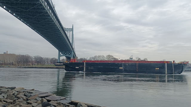
There were a lot of people walking around at the time, but we got some great views of the bridge and back toward Manhattan as we headed south to the bottom of the island. Roosevelt Island was in view from there as well. We walked to that also on a previous holiday hike.The paved pathway remained near to the waterfront, and weaved a bit near the vehicular road. We paused for a few moments for everyone to use a restroom, and then continued to the east.Soon, we passed beneath the Robert F Kennedy Bridge, or the Triborough Bridge, at the suspension section over the Hell Gate, from Wards Island, New York.
The complex expressway viaduct has a series of spans connecting Manhattan, the Bronx, and Astoria Queens over Wards and Randall's Islands, which were previously two separate Islands connected by a landfill.
The spans terminate in all three boroughs with connection on Randall's Island.
It has been described as "not a bridge so much as a traffic machine, the largest ever built". In fact, the Manhattan connector incorporates the largest vertical lift bridge in the world.
Ground was broken for the span in Astoria in 1929, but was badly delayed due to the Great Depression.
The Y-shaped sky highway was opened July 11th, 1936, with President Roosevelt in attendance.
We continued walking beyond the bridge, and then turned to the left.
The southern tip of the island was the point of the RFK Bridge, and we continued to the east a bit more. This brought us along soccer fields and baseball fields, and approached the Hell Gate Bridge.
This bridge was opened in 1917 by the New York Connecting Railroad, as a connection between the Pennsylvania Railroad and the New Haven Railroad.
The amazing combination five span structure is over 3 miles long.
The waterway it crosses was so named by early Dutch settlers to the region.
The 1,017 ft long combination span bridges between Astoria, Queens, and Wards and Randall's Island Manhattan.
I had found out before putting this hike together that there was a new sort of "rail trail" through this area. Not on the Hell Gate Bridge itself, a pathway was put through the arches directly between it, spanning a distance of maybe two miles.
I planned to do most of this, with a little deviation along the way.
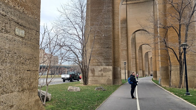
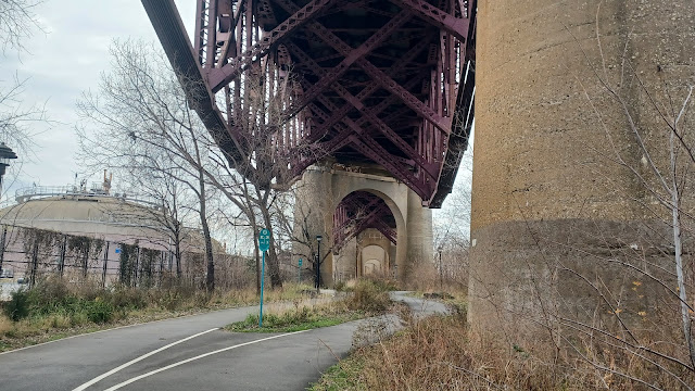
The path turned to the left as we approached the bridge, and then went directly under the towering arches of the bridge supports. This was certainly one of the great highlights of the hike.
As we continued and went around a curve, there were bridge sections of deck truss structures that seemed to sag down toward us like the belly of a giant pig.
A side path went off to the left at one point with an odd surfacing, into a random freshwater meadow in the middle of the island, so we checked that out too.
The path had split in this area, and we came back to beneath the bridge. We continued north for just a little bit more, and then turned to the right when we got to the next side road that went out to more ball fields and buildings and such. We turned here and headed east, which afforded us some really good views of the Hell Gate Bridge from a bit further away.
These ball field areas are what was formerly the Sunken Meadow Island, the section that was connected to the other two island in 1955.
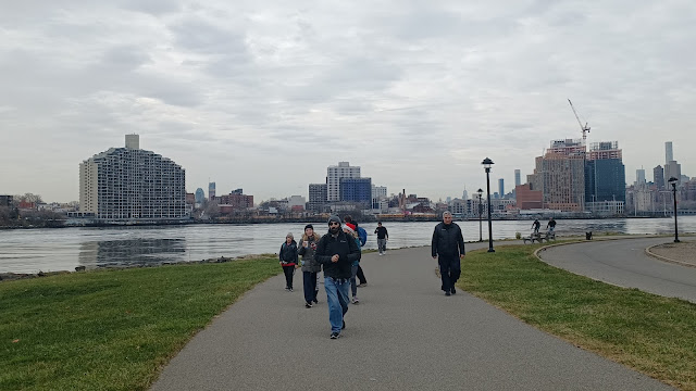
At first, we were just along the ball field edges, and along the Sunken Meadow Loop road, but after we got to the east side, the path diverged a bit, and it was just dedicated paved walkway on the waterfront. It was another particularly beautiful section.
To the northeast, we could see North Brother Island and South Brother Island. The north one has ruins on it, and I have friends who have explored it. It looks pretty amazing. It was originally established as a Smallpox quarantine hospital in the 1880s.
We could see out the East River, and directly to the right of us, also east, was the Astoria Energy power plant which closed in 2010. The original power plant here was the Charles Poletti Power Project opened in 1977. It was known to be among the dirtiest in state of New York.
Plans are in place to replace the power system there with a battery system.
We continued past the Stephen Perry Grove on the far east side, and then weaved around to head west a bit again, along the Bronx Kill. We had a good view north to the New York Post building.
When we got back to beneath the Hell Gate again, we turned hard right to continue walking the pathway beneath it.
Cory and Linda's stepson was starting to get really tired at this point. Cory kept holding back for him, and I held off and had a talk with him a bit too about having stamina and how to get mentally in a place to get him through. I was impressed that he was willing to hear what I was saying, and took the time and encouragement I gave him to heart. He started pushing on a bit better. Cory did end up leaving the hike a bit early to get him out, but he pushed farther than was expected, so that's cool.
Linda's sister Katie was out for the first time on this one, and she did really great. No complaints at all, and handled the mileage like she's been doing it for years.
We got across the Bronx Kill, and then soon crossed over some active railroad tracks on the trail. This was apparently once part of the New York, New Haven, and Hartford system. In the past, there had been a round house and multiple tracks through this area.
My plan from here was to hike as close as we could along the Bronx Kill and then the Harlem River heading to the north. I'd never tried to follow this waterfront before, and it looked like there was some cool stuff with only a bit of road walking.
There was interesting stuff even on the roads. We turned left at the end of the trail, when we reached 132nd Street.
We'd have to follow that to Brown Place, and then turn right up to Bruckner Blvd.
Along this route, we got a view of the rear of the Bronx Grit Chamber, part of New York City's first major push to alleviate water pollution.
Built in 1936-37 in neo-classical style, it was able to handsome fifth of the city's sewage. It looked interesting from the start, so I took a photo of it and decided to look it up later. I knew it must have had some sort of significance.
We had to dip down under from Bruckner beneath the Third Avenue elevated approach to the Bankside Park area, where we had nice walkway directly along the Harlem River at some tall buildings.
Along the Harlem River, the tracks of the former New York, New Haven, and Hartford Railroad were out on a small parallel to shore causeway bridge unlike anything I'd seen before, and we also had a good view of the Third Avenue Bridge.
The Third Avenue Bridge was originally a multi truss built in 1898. It was bidirectional until 1941 and switched to one way.
The trusses were sold in 1955, and replaced with a rebuilt bridge in 1956. The swing span was replaced again in 2004-2005.
The walkway from this point had not been completed. I knew it looked like that from the aerial images, but I figured maybe something more was in place by this point. It wasn't, and so we had to turn back and head to the north to 134th Street and head northwest.
We soon made our way toward the Major Deegan Expressway, which was an elevated road at this point.
The highway began in 1936, and the full route was opened in 1956, named for Major William Francis Deegan, of the Army Corps of Engineers and father of the American Legion, who died in 1932.
I was not expecting it, but we did get a bit of a nice walkway beneath this highway for a time. At first, we went through some sort of construction area, but it got nicer.
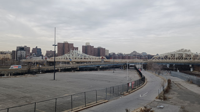
We also passed beneath the Harlem River Lift Bridge, also known as the Park Avenue Bridge, a rail bridge that carries Metro North's Hudson Line, Harlem Line, and New Haven Line across the Harlem River between Manhattan and the Bronx NY. This bridge is the fourth permanent bridge to carry rails across on this site.
The current lift bridge was opened in 1956 to replace the previous 1897 iron structure.
The site has been a railroad crossing since the New York and Harlem Railroad in 1841. It was replaced by the second bridge by New York Central in 1867.
We continued north and passed the Madison Avenue Bridge. The bridge was designed by Alfred Pancoast Boller and opened in 1910 to replace the 1884 swing bridge at the same location.
We continued on under the bridge to the north, and there was construction going on at the next bit where I wanted to get off of the road, at Mill Pond Park. We had to skip the first bit of that unfortunately.
We were able to get out to the park at a peninsual area with good views. The odd railroad continued just barely off shore from the pathway. We also had a view of the Harlem River Swing Bridge. This was originally built in 1905, replaced in 2006.
The pathway led us along the water, weaved out around the Stadium Tennis Center, and then around a little cove by the Bronx Children's Museum.
This is the only building remaining from the Bronx Terminal Market site, originally the power house, built between 1925 and 1927.
Up the river from this point, we could see the pretty McComb's Dam Bridge over the Harlem River.
There once actually was a dam at this site, built an 1814, with a 7 ft lock for navigation. It caused problems for navigation, so it was replaced by a wooden swing bridge in 1860 or 61.
Replacement wooden structures, and some iron followed in the years after that, until the current Bridge was designed by Alfred Pancoast Boller and installed between 1892 and 1895.
This is the third oldest major bridge still operating in New York City.
We had to leave the waterfront directly in this area, and followed the walkway along the west side of the Major Deegan, at the approach to the McComb's Dam Bridge.
We crossed the road at the bridge, and Mike Selender pointed out the Yankee Stadium in view to the right.
The old Yankee Stadium was built in 1923 and demolished in 2010, and is now adjacent Heritage Field. The construction of the new Yankee Stadium meand destroying part of the original McComb's Dam Park, which fell under a lot of scrutiny because it meant the removal of 377 mature oak trees.
We headed north along the frontage road to the Major Deegan, which descended a bit. We could see a foot path below us, which was to be our trajectory. It was lined with tons of trash in unbelievable amounts.
Once we were level with the ground, there was a trail entrance to the left, with a chain link fence as I recall, but we were able to pass right through to continue.
We meandered along the trail, which was just below the Major Deegan, kind of out of sight. A pleasant little walk to the north for a bit, and then we climbed up some steps to the Sedgewick Avenue pedestrian bridge over the Major Deegan.
This pedestrian bridge does not exist simply for the sake of the trail. This bridge served the Anderson Station, which is no longer active. Just below us to the left, the stairs that led down from the foot bridge still exist, but are blocked off. They no longer go down all the way to the station, but cut off just at the last flight.
This was supposedly the only station where you go downstairs to an EL line, or elevated line. It's also apparently the set of stairs that Chris Rock rides his bicycle down in the movie "New Jack City" and almost gets hit by a train.
We turned right and crossed the bridge, and reached Summit Playground. I think we went up to Ogden Avenue and headed north. I had some more grand plans for walking through more park areas, but we ended up not doing it. I was more in a hurry to get to the High Bridge to the north.
We did walk through the Merriam Playground park, until a set of stairs that went down to University Blvd. We followed that, and then turned right to the north again, and soon reached the entrance walkways to the High Bridge.
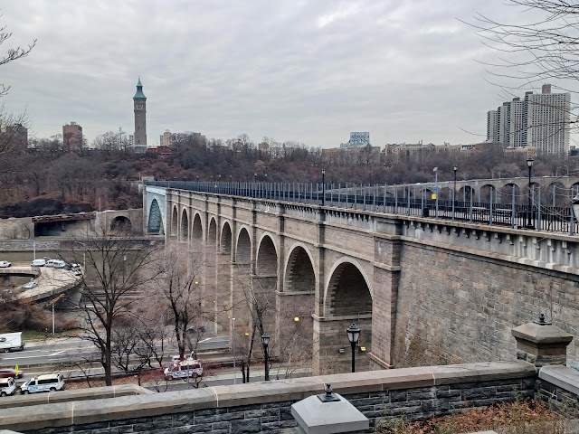
The promenade on the bridge is just excellent. It retains all of its historic ambiance, except they've added some high railings on either side where it used to be much more open.
We looked south from the bridge at the expansive rail yards and cityscape beyond.
To the north, we had a view to the Alexander Hamilton Bridge and the Washington Bridge over the Harlem River.
Alexander Hamilton Bridge is an open spandrel steel arch completed in 1963 and carries I-95. The Washington Bridge was completed in 1888. It was widely praised as exemplary work and has an appearance that was ahead of its time. It really doesn't look like any bridge built at that time. Certainly a more modern and at least early 1900s look.
As we crossed the bridge, we had a splendid view of the tower in High Bridge Park in Manhattan. This ornamental tower actually served water tower function, and provided water pressure for the aqueduct.
We reached the other side and admired the view from there as well. From this point, my plan for the hike was to turn south and follow the waterfront on the Manhattan side. I'm pretty sure I've never done the entire thing over there yet, although I've hit pieces of it before.
The first part of this would be more of the Old Croton Aqueduct, which is at first a paved trail that turns hard left along the slopes.
There was a set of steps up into the High Bridge Park, and I had considered going up to it to visit restrooms, but then decided against it. I think some of the group went up to use them quickly while the rest of us waited below.
As we continued away from the bridge, there was an enormous hollowed Sycamore tree to the right, where we stopped to muck about a bit again.
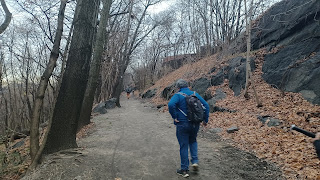
Once we were all together, we continued along the trail to the south. It was paved at first, and passed through some impressive rock outcroppings that were busted through to lay the incredible system in 1842.
We continued to where the paved trail went uphill to the right, and the Old Croton route continued as an unpaved pathway along the slopes ahead. I understand this area is known as Coogan's Bluff.
Eventually, the trail emerged at Edgecombe Avenue and 158th Street. Here, we left the aqueduct route, and turned to the left to reach the John T. Brush stairway that leads down to the bottom of Coogan's Bluff.
This is where we the first major split of the group occurred. When just a few people head off somewhere, others tend to follow, and in this case, it was more than half of the group.
I had taken to the bottom of the stairs, crossed the Harlem River Driveway, and then followed steps down along the right side of that into the New York City Housing Authority Polo Grounds development.
Apparently, this area was some sort of affordable housing development that was built on a former polo ground. We walked the pathways through this, and turned south on Frederick Douglas Blvd.
There is no walkway directly on the Harlem River at this point, so it's necessary to do some little side trips.
We turned to the left to head through Brigadier General Charles Young Triangle, a park with walkways, and headed out toward the waterfront more closely.
The way to get through to the water was kind of complicated. I tried going through one way, but there was no access and we had to turn back. I think that's what ended up knocking out the rest of the group that left early. More of them didn't even realize I wasn't part of the group that headed off.
Jess Collins was among the ones that left thinking that I was with them, and she hurried back to find us on this stretch near Malcolm X Boulevard.
Pathways start back up at the Harlem River Swing Bridge, but there is no way out to them initially. We had to stay on streets and other paths to get back over to it.
There was a foot bridge over Harlem River Drive at 142nd Street, and so we used that to get over.
By this time, it was just about totally dark, and the only ones remaining in the group were Justin, Jenny, Jess, and I think John and I. Still, we continued on to the south.
My goal was that I wanted to get back to where I'd already definitely walked this before, or better, back to the Wards Island Footbridge where we crossed over originally.
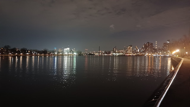
I feel that everyone was seriously missing out. The views along the waterfront in this lighting were among the best we'd had all day.
As we approached the Madison Avenue Bridge again, the way it was lit up over the water was just amazing.
We continued on beneath Madison Avenue, and then headed toward the Harlem River Lift Bridge, which looked eerie and amazing at night. We didn't see any trains go over it as I recall, but it was still just awesome.
Just after the railroad underpass, the walkway was officially closed. Storms and such had damaged sections, and it was fenced all off.
However, that did not stop us, and in this case, it was a good thing there were so few of us or we would not have gotten away with it.
We went right out to the Harlem River, grabbed hold of the fence, and swung ourselves around to get into the closed off area.
From there, we had really easy walking in sort of bulldozed land between the Harlem River Drive and the river itself.
We passed beneath the Third Avenue Bridge, continued along the waterfront, and then approached the Willis Avenue Bridge. The original bridge was a swing span that opened in 1901. The replacement swing bridge was opened in 2010.
Here, I recall we had to sort of jump the median and head over into traffic, then under another on ramp bridge before heading back over to get on the closed walkway again. This bit didn't have any fences blocking anything on it, but then again, I don't think anyone really bothers trying to walk down where we were.
There were some sort of old slogans, "Out of Many, One" which was apparently a past US slogan, designed into one of the bridge supports we were walking beneath.
We continued onward and soon passed beneath the lift section of the RFK Triborough Bridge.
We went around or under another fence after the bridge, which took us to the Bobby Wagner Walk section of the walkway, once again open to public, and continued to the south.
Pretty soon, we came to the foot bridge that crossed the highway again, this time to 120th Street. Everyone else decided they would continue across the bridge and head back into the city here, but we were not yet at the pedestrian bridge we first crossed the Harlem River on.
In that moment, I told them to go on, and I would continue the hike along the waterfront alone.
They tried to talk me out of going off into the city by myself, especially on a secluded walkway, but I didn't give them any choice but to wave goodbye, because I left very fast.
I was a bit annoyed that everyone all followed someone other than me thinking they were going the correct way earlier, but I got over it pretty quickly. The views of the area up ahead were just too amazing to let anything else get me down.
Soon, I reached another closure of the walkway. I'd have to handle this one by myself. I thought it was probably not a good idea to throw myself out over the water alone, and I didn't know what I was facing up ahead, but took the chance anyway.
It wasn't really all that bad, but it was far worse than any of the closed stuff we had dealt with just a little earlier. There were giant washouts in the paver and brick walkway sections that had to be walked around, and there was no room for error. I couldn't just enjoy the views, I had to make sure that in the dark, I didn't step off into a ditch and have a dangerous and painful fall.
I moved along fast, but stopped to admire nice scenery along the way.
To my right, there was the lovely Benjamin Franklin High School, now Manhattan Center for Science and Mathematics. The original high school was built in 1934 and closed in 1982. It reopened as the four year specialized high school it is today. The lighting on it, and the vantage point I had was really the best way to see this awesome structure in my opinion.
The moon soon came up, and it was just ahead of me on the water. It just looked amazing. I made the turn along the waterfront, and pretty soon the foot bridge we crossed earlier came into view, with an eery lack of lighting that made it stand apart against the well lit cityscape beyond, different from the previous bridges.
I continued on the walkway from there as well. I had considered walking it all the way south and then cutting inland when I got to Penn Station, but then I saw that there was an at-grade crosswalk exit to the walkway at 96th Street, so I made my break for it there and hurried to the west.
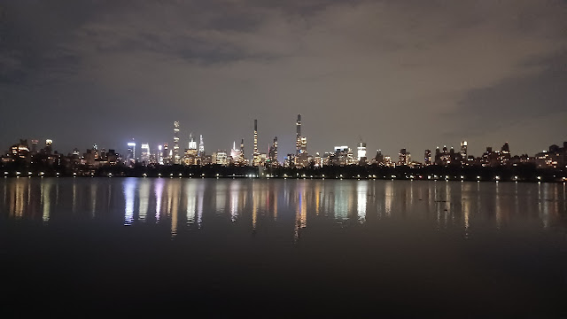
I got through the several blocks pretty quickly, and crossed 5th Avenue to enter Central Park. I then hurried up to the edge of the water of Onassis Reservoir and started following the perimeter to the west and south.
Originally the Central Park Reservoir, Upper Reservoir, or New Croton Reservoir, it was completed in 1862 above the Yorkville Reservoir, Old Croton Reservoir, or Lower Reservoir, which is today the Great Lawn and Turtle Pond.
This reservoir was decommissioned as water supply in 1993 and renamed for the former first lady in 1994 to honor her contributions to the city.
I started getting a bit more of an uneasy feeling as I turned to the corner and went south a bit. By this time, everyone was worried about me and wondering where I was. It was cold and I was alone moving along quickly.
There were a few characters just below me on another path in the park, but I tried not to look like my movements were urgent or fearful. They probably didn't really care anyway, but I started becoming a bit more situationally aware. I suppose because I was still drinking at the time, I was probably in a much more hippy mentality just before this as well, and the fast exercise woke me up a bit.
I started to realize the time. If I wanted to catch the next train out of the city, I had to hurry. It was going to be cutting it really close. I didn't want to be getting home at really late. It must have been the one just after 8. If I got that last one, I could get back to NJ by 9, and hopefully home by 10, but there were too many problems.
I had ridden in with Joe Millionaire, so I did not have a car waiting for me at Short Hills. I would have to Uber back from there myself or something.
Before I was in too much a hurry to go, among the phone calls I was getting was one from Mr. Buckett; he and Eric were hanging around at Penn Station area and getting some food. I asked them if I got there, could I hitch a ride back with them. Eric only lives a few blocks from me, and this could just work out.
Now, I had to hurry.
I dashed to the south along the walkway, across West Drive, and then to the 86th Street subway station.
One of the big surprises of this hike was the ease with which we could get onto the subways.
It used to be that we'd have to purchase a Metrocard, wait in line for a clerk or a machine, and then slowly get through the lines. Now, with the credit card taps, one can just get on the train and have no problem at all. It is incredibly fast and easy.
I dashed down the steps, tapped my card, and quickly boarded the train after asking for sure if it was the one that I wanted. I checked ahead with Google and such to make sure I could get on the correct one.
I'm not all that familiar with the city, but thankfully this worked out well.
In very short order, I arrived at the subway station across from Penn Station and Madison Square Garden. I think there's a way of walking in there underground, but I don't know it well enough. I climbed to the surface, dashed across the street and into the building on the other side.
At this point, I was running hard. I had minutes to spare. I had to be careful not to run anyone down on my way. I was also still holding an open beer.
I found NJ Transit, went down the steps to the train numbers, figured out which track my train was leaving on, and ran down the next flight of steps again.
When I got to the platform at the bottom, the train was boarding, and I saw Mr. Buckett standing straight ahead of me. He looked surprised to see me running toward him.
We ran and got onto the train, sat down, and we were good. The train took off in almost no time, and I was thrilled that I made it back so quickly. What a major stress relief.
While I was on the train, I got a selfie text of Joe Millionaire and Alyssa on the train. He was so out of it that he didn't realize I was supposed to be heading back with him.
Thankfully, this was all working out and it was no problem. Joe Millionaire and Alyssa got to spend a lot of time together, and as a result of this, they started a relationship, and I'm very happy for both of them because I think it's exactly how people should come together, doing things they enjoy. Joe Millionaire actually missed his station, and so Alyssa drove him back home.
I continued having my beer all the way back on the train, feeling really quite excellent that not only did I make it back in time, I didn't have to drive at all!
I felt so relaxed. We made our way back to the Short Hills station, got off, and jumped in with Eric. I actually got to finish the remainder of my last beer of the day at home talking to Ev.
I think Joe Millionaire had the right idea about how to approach this hike. Uber on in, don't worry about any of the driving, and really enjoy the day. It really made a big difference for me not worrying about whether I would have it in me to safely get home, or that I'd have to sober up very strategically.
Sometimes I put too much thought into the responsibility of it all, that I don't quite hit the mark with how to be responsibly irresponsible, but this time seems to have been a success.


















No comments:
Post a Comment