

Hike #1618: 8/11/24 Crandon Lakes to Marksboro with Mike Selender, Kirk Rohn, Violet Chen, Dan Lurie, Professor John DiFiore, ?, David Adams, Robin Deitz, Sue Bennett, Diane Reider, Galya, and Everen
 |
| Circa 1910 Marksboro Station by J E Bailey |

This next trip would be another rather close to home foray. Of course, I wanted hikes that would have swimming spots, and I wanted to have a bit more relaxing terrain for at least some of the time, and I put together something that I think came out rather well.

The hike came together first out of a conversation with Dan. He lives up in Crandon Lakes, a small double lake community in Sussex County from which I figured we could hike up the Kittatinny Ridge.
The plan I was pulling together would go directly from his house up over the 1500 foot high ridge on the closed off Brink Road. We could then make our way down into the Walpack Center area where there are good road closures making for nice walking.
I traced out some routes that would bring us through the Delaware Water Gap National Recreation Area on to the Millbrook area, or perhaps Blue Mountain Lakes.

The problem with a lot of this is that it is a long shuttle around, and there are questionable accesses on the routes.
I felt okay about the route, but then Dan and I kept talking about it. I had a hike planned and ready to go, but at the last minute, he had me interested in Swartswood again, and then other stuff near to it, and then other stuff I'd never done, and everything changed.
I switched everything up to a hike that would be much on Paulinskill Valley Trail near the end, back roads near Dan's place, and Swartswood State Park and associated properties earlier on.
Although I very much love the Delaware Water Gap region, I was much more excited for this oddball thing I'd concocted, and it was probably the better hike to do in this situation anyway.

The meeting point would be the end point at the Marksboro trailhead on the Paulinskill Valley Trail. This was the former New York, Susquehanna, and Western Railroad, which was completed through this area in 1881. It continued to Jersey City to the east, and to the west, to the Stroudsburg area on the Lackawanna at Gravel Place.

By 1893, by way of the wholly owned subsidiary, the Wilkes-Barre and Eastern, the NYS&W had the most direct route from the coal mines to Hudson River markets including New York City.

This was rather short lived however, because other lines were improved upon and straightened. The Delaware, Lackawanna, and Western did major improvements starting in the early 1900s, which made their trips much faster. The antiquated NYS&W had to impose low speed limits for its many curves. As such, the WB&W was abandoned by 1939, the NYS&W was abandoned through the Delaware Water Gap in the 1940s, and the rest of it from Columbia west to Sparta was abandoned in 1962.
From 1886 until October 1961, the Lehigh and New England also had trackage rights over this line, which accounted for most of the traffic on the NYS&W in its later years. The year after that closed up, this section of the NYS&W followed.

The line was considered for use as buried conduit when the Tocks Island Dam project was taking shape, but that was defunct by Carter in 1979, and then officially deauthorized in the early 1990s.
After that time, the right of way from Sparta Junction to Columbia became the property of the NJ State Park Service. Work was done to redeck the bridges, and the trail was nearly thirty miles long. It's probably my favorite rail trail in the State of New Jersey.
Our group pretty much took over the entire parking lot at Marksboro. I didn't think we'd have all that many of us, but it was quite a lot.
While we were there, a huge group of Spanish speaking people came through and tried to pull into the lot, and they didn't know where to go. It seems like they were trying to go to White Lake when they realized there was no swimming.

I tried directing them to Swartswood, not knowing at the time that swimming was also closed in the state park up there. It was kind of a traffic mess for a bit.

When we were all ready, we piled into a few cars and headed north to Dan's house at Crandon Lakes, located on West Shore Drive.
We got everything together and ready to begin our hike, which would follow along the little used development roads around the lake's north and west sides.
The community was developed in the 1960s around two man-made lakes in Hampton and Stillwater Townships.
Water recreation is limited to Community residence and their guests, but as we were guests of Dan, we were able to pass on through.

West Shore Drive took us south for a little bit, around a corner, where there was a guy's house with lots of Trump 2024 signs, and even his truck was well decked out in it. He was outside, and we waved hello as we went on by.

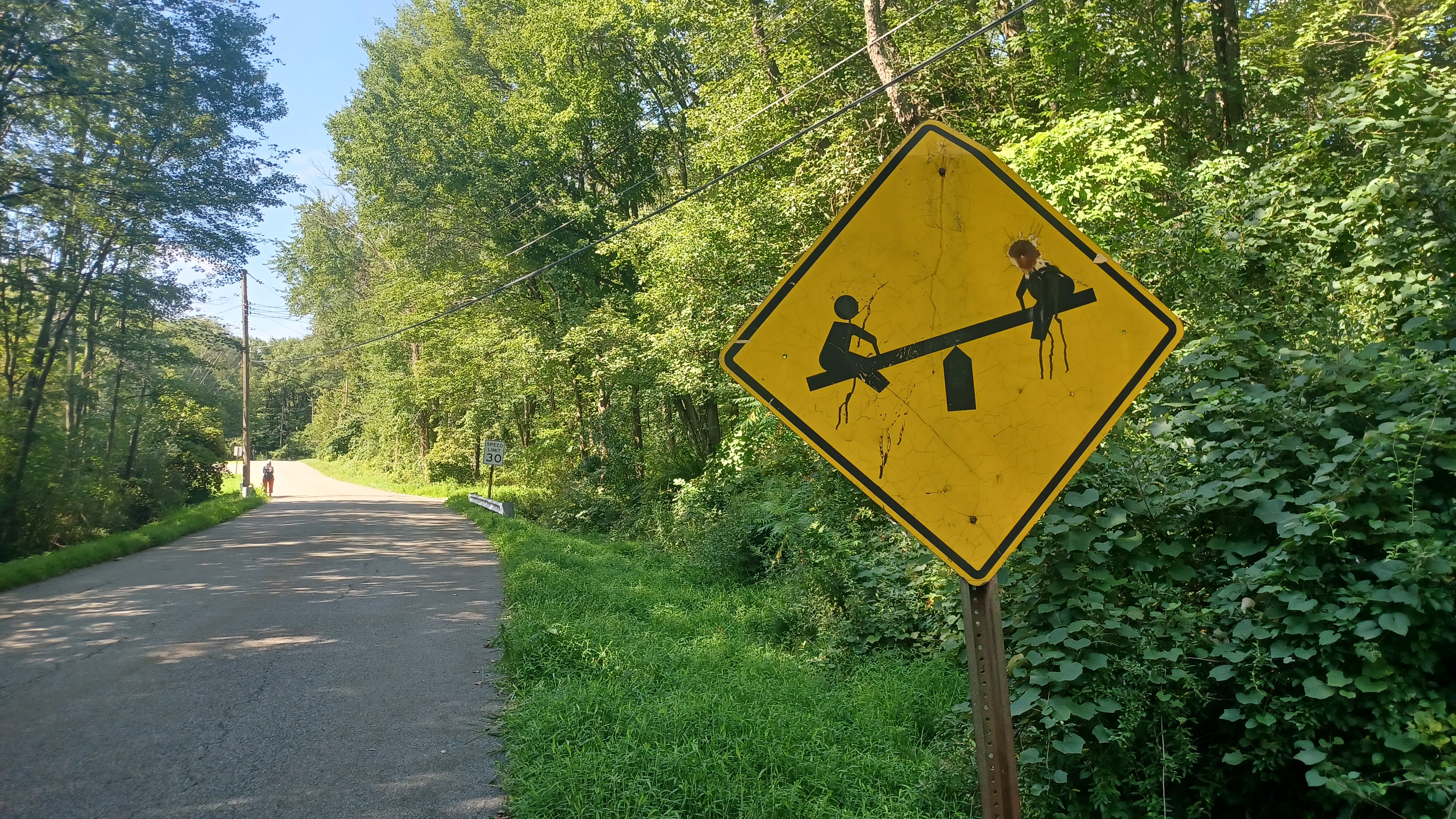
We continued ahead, and the community felt a little weird. There was one of those yellow signs with children on a teeter totter, but both the of the heads on it had bullet holes through it!

As we continued down the road, the guy from the house drove by us at least three times, which I at first took as rather odd. I don't know if he was looking to see what we were doing or what at that time.
We continued ahead, and soon reached the beach on the west side. It said not to swim when there wasn't a lifeguard on duty, but John and I both got in quickly and got back out anyway before moving on. Ev loved this spot, and actually climbed up onto the lifeguard chair by himself.

We continued from here along the edge of the lake on the road. This eventually brought us out to and across the main dam of Upper Lake. The lower lake is much smaller to the south.
I had considered walking from this area along the Lower Lake Road, which appears to be abandoned where it connected between the two lakes. Dan seemed to think it might work, but it wasn't looking welcoming from any of the approaches, despite what it was showing on Google Maps.
From the south side of the dam, Upper Dam Road used to continue straight and went across a sort of lawn area. We had to turn left on East Shore, then right on Minisink.

We went to go down Lone Pine Trail, which leads to some more homes, but then there were a lot of signs reading "no trespassing" and such, so much so that I figured it wasn't that important to meander through. We headed out to the southeast, to Copeley Road, and turned right.

The road walk was kind of crummy because there was not a very good shoulder, but it was only seven tenths of a mile until we got to the left turn into the Willowcrest Lake Trail area.
I'd done the trail here before, when I used to live up at White Lake. It is a satellite property of Swartswood State Park, with a large loop trail going through it.
Some of the property has changed a lot, and beaver inundation of the Spring Brook, which feeds Willow Crest Lake, has put some of the upper trail under water. As such, it was closed. Now, it is a sort of lollipop loop through the property where one would have to double back, unless of course they did what we did.

I really don't know any of the history of Willow Crest Lake. The best I can come up with was that it was built between 1963 and 1970. Maybe it was a flood protection project, or maybe it was intended to be a third Crandon Lake that never got developed.

Whatever the case, it ended up in the hands of State Park Service, and by the time I was living at White Lake, the dam was undergoing some repairs. Jillane and I walked out there and did the loop back then, and found a pump going unsupervised at the dam site.
I had only walked it maybe twice back then, and never returned to it. Obviously, I never got around to having a group hike that included this piece of property, amazingly. It was about time I had something to go through.
We reached the entrance to the trailhead parking, and walked down the short gravel drive.
When we arrived at the parking lot, we took a little break to let everyone catch up.
In the parking lot, it was a little odd to see that the pickup truck with the guy with the Trump flags and political signs was parked right there. Had he predicted where we were going?

It just seemed kind of strange that he was parked there, and part of me really wanted to meet him.

While we were waiting, a state park maintenance truck, a small Ford Ranger, pulled in. The guy was apparently there to do weed whacking, but then just turned around and left without working.
Once we were all together, we started heading down the trail into the woods on a gradual descent. Ev got out of the stroller to walk this section himself.
As we headed down the trail, the guy was walking back up the hill toward us as we headed down.

I said hello to him as we were heading down, and I think I made some sort of comment about how we keep running into each other, and he couldn't have been a friendlier person to meet.

We talked to him about where we were going and what we were doing, and he told us of how he liked coming back to this place as well. He also went on about how he did some volunteer work of his own. I encouraged him to get in touch with Blanca from the state parks to see about getting officially recognized as a volunteer.
He told us about how the trail wasn't really kept up by the state at all. Indeed, the entire loop I'd known from the past was of course closed by necessity, but we didn't even see the worst of what we'd have to go through yet.

I figured for certain that this guy would hate Governor Murphy and the dismantling of the parks that have gone on under his regime, since he was obviously a big Trump guy. It was very interesting to hear from him that he is neither a Republican or Democrat. He considers himself independent. He told us that when it comes up, as it tends to do because he's a Union guy, he says "I'm not Democrat. I'm not Republican. I'm MAGA", for the "Make America Great Again" slogan Trump uses.

He told us that he was originally from Brooklyn I think it was, and I asked him if he knew Paul who works at the state park, who is just a wonderful man that does so much for the park and his community.
He didn't know Paul, but I again encouraged him to get involved with the park. I also introduced that he was actually Dan's close neighbor, which is always a good thing to have connections.
We continued on down the trail after the nice interaction, and soon reached where the loop trail used to break off to the left. We of course continued right, and it was easy for a bit as it became an old woods road. This brought us out to a spot above the wetlands along the Spring Brook.

I laid in the brook pretty much right away and cooled off quickly before continuing on.
The trail got to be a little rough at this point. It had to cross over the wetlands, and it was horribly grown in. I became a bit annoyed that the kid had left without weed whacking at all.
I got the stroller through some of the mess, but it just got too thick. Kirk picked Ev up and carried him through some of the messy causeway, some of which was literally just walking on top of a beaver dam. There was really no getting through this seciton at all without getting wet.

There were some stepping stones along the way, but this trail needs more continuous attention if it is to stay open. Most people would have turned back before the rest of it.
When we got to some high and dry land on the other side, we took a little break to get allow everyone to get across. Some of the group had taken their shoes off to do this.
While waiting, there was an old farm implement along the trail to the left, which was some sort of tilling machine that Ev was fond of.

Once everyone was together, we continued walking. There is still a portion of the original loop in place on the far side of the property there, but we kept to the one that was more to the north and closer to the waterfront.
The land was somewhat rocky, but we were able to get through alright.
Ev continued to walk by himself much of this time. He rather enjoys the footpath sections walking himself more than rail trails and such. Kirk stayed close to him much of this time, which was good because the terrain was not bad for the stroller being light weight, but if Ev had been in it, I would have had some trouble in this section.
We meandered through woods with old stone rows, former farm lands, heading to the southwest. We moved off away from the creek route fo ra bit, and eventually descended to near the edge of Willow Crest Lake. This lake is far smaller than it was several years ago. It seems that the work that was done in 2011 was to lower the dam somewhat.
Now, there is still a lake there, but it is more of a wetland than anything else. We followed along this for a bit, and my plan had been that we would make our way from the trail through woods to the southwest to reach Old Tannery Road when we neared the south side of the property.
 |
| 1860 |
As we got closer to this spot, it got rather steep. The dam came into sight, but it was not really easy to get to.
We had passed a couple of nice lake outlooks, and then reached a point where the trail went steeply up to the left away from the lake, to begin the loop back toward where we'd come from.
Some of the group bushwhacked through over to the dam. There was an informal little herd path that went down through the woods to the dam site. With a little help in front of me, I was able to push the stroller through this mess a bit. Ev had gotten back in the stroller up until this point, and then had to get out again so that I could safely navigate this. Kirk again helped with this spot.
We got down to the dam, and while Ev was fussy about getting out just before this, the sort of ramp and step style construction of the dam was interesting enough that he was happy to run across it and look around some more.
We got across the dip of the dam and up the other side, where there was a good woods road that weaved around from the lake and up to Mt Benevolence Road. It wasn't the way I had really intended to go, but it ended up being a better route for us anyway.

We started heading up the hill here, and then there was a good spot with a deeper part of the lake to the right, with a rope swing!
I was immediately tempted to try it out, but I also didn't want to take any unnecessary risks.
Galya's cousin came with us for the first time on this hike, and he ended up being really cool. He appreciated the good drinks, and was up for whatever adventure we dished out. He was quick to try out the rope swing, and it looked great.
I think he told us that he had been in the Israeli army.
When I saw him safely land it, I absolutely had to do it, and agreed that it was great. I really needed to cool off too after all of that heavy pushing through the rougher terrain. It ended up being the toughest part of the entire hike.
We were done with the tough stuff from here. We simply followed the access road up and around a bend, then through sparse young forest that had been fields not half a century ago. This brought us out to Mt Benevolence Road, which was rather busy, but not too terrible. We turned left here.

We turned right here on Rt 521 through the pleasant little settlement heading west.
The settlement, founded by Jonathan Oliver in 1824 as a milling town for his employees, was originally sparsely populated area known as Rum Corners. It was then renamed New Paterson.
In 1852, the settlement was renamed Swartswood, for British Militiaman Anthony Swartwout, who along with his wife were brutally murdered in 1756 during the French and Indian War by a group of Lenape siding with the French. Two of his children were taken captive.
It was felt that resurrecting the grisly page in history would be harm the community, but lake recreation prevailed, and Swartswood State Park, the first state park in NJ, opened here in 1914.
It is today still a quaint little community, not much changed from days of old.

We continued along the road for a short distance, and then reached the intersection with Swartswood Road on the left where we turned. There was an historic old church on the left after turning.

I had an historic photo of a church in Swartswood saved to me phone from probably years ago, and so I had to sift through all of my files to find this one, because I hadn't the night before to mark it in favorites.
This was the original church of Swartswood NJ, the Swartswood Methodist Episcopal Church, built in 1856.
Today, the steeple is gone, and it no longer serves as as a church.
The current use of the building is the Samaritan Inn, a non profit organization that provides emergency food, temporary shelter, and counseling to homeless families in Sussex County.

We actually passed the building because I couldn't find the photo yet. Ev fell asleep in the stroller, and so I had the group watch him when I found the photo, and ran back to get the modern shot of it.

Mengo's Pizzeria and Swartswood Deli were right next to each other just ahead. I'd eaten at both when I first started working for State Park Service, because it was the closest thing, and was just up the road a short distance from the park.
I think I got some pizza at the one place, but Ev was too passed out to really eat. Lately, I've been making sandwiches and such for him to have whenever he happens to wake up.
While there, the walls of the pizza place were completely covered with lots of historic postcard views of the Swartswood area, many of them I'd never seen before.


I walked around the place trying to get good sort of scans of each one of them with my phone camera, thinking I might be able to match some of them up with some modern views as we continued.

I'm not sure if I got any of them accurately, but either way, they are nice past images to have featuring the park.
We continued from the lunch stop ahead on Swartswood Road to the east. This brought us soon along the edge of Stillwater Park, which we really didn't go into very far, just enough to take a break in the shade and I think use the restroom. We then crossed the street and walked through the front of the front lawn of the Our Lady of Mt Carmel Catholic Church property.

We continued ahead and soon crossed over the tributary between Swartswood Lake and Little Swartswood Lake, which had a pretty scene with lily pads and rather still water.

The water body known as Little Swartswood Lake is a natural glacial kettle hole lake with no dams. Larger Swartswood Lake is the same, except it has a dam that enlarged it for milling purposes originally. The "kettle hole" style is what White Lake is, where I used to live. Some might say that this is not officially a kettle hole style, but rather glacially scoured.
There is an access to the left into the park property, where there is a small boat launch to the smaller lake. There are homes built along this one further to the north.

We continued ahead, and there is a trail that goes into the main part of the state park land on the right, almost across from the access to the boat launch. The trail here is known as Emmon's Path, and it was nice, flat and easy for the stroller to pass through. I asked Ev if he wanted to get out, but he said no.

Considered to be New Jersey's first state park, it was established in 1915 by the state's Forest Park Reservation Commission. The glacial kettle hole lake here, along with Little Swartswood Lake, are some of the largest freshwater holdings in the state.

The main Swartswood Lake was enlarged in 1838 when a mill and dam were established by George Keen at the outflow to the west.

The lake was used as a privately owned recreational facility, and landowner and businessman Andrew Albright Sr fought to prevent free public access until the state secured the property. After his death in 1905, his heirs sold 544 acres including lake waters to the state in 1914.
The park has expanded over time with acquisitions including Emmans family farmland.
Facilities include trails, camping, boat launches, swimming beach, and picnic grounds, and it can get very busy in the Summer. I spent a good amount of time weed whacking and such at this park when I first started with the state.

The trail remained very easy to walk and was quite pleasant. We meandered on through the woods, and were often close to the water of the lake after a bit. The trail emerged into the campgrounds, where in my earlier park days I was sent with a lap top to conduct bear education for campers.

It was kind of nice to pass through. I'd known the park well before I ever worked there from doing hikes in the past, but it was also different having worked there.
The trail left the campground roads and came back to them at times, to stay more into the woods along the way. We then made our way to a little boat launching area. I think I took a very quick dip at this point, which was nice and relaxing. I expected that we would be heading to the beach to swim pretty soon, not knowing that the entire lake was closed to any bathing due to Harmful Algae Bloom.

That stuff is all over the state, and it seems like most areas are closed because of it.

We took the trail over a knoll and past a couple of nice big trees, then weaved around a little peninsula of land that makes its way into the day use area. We passed a lot of people, then a small boat house area as we headed toward the beach.
It was disappointing to see that we couldn't get in. We'd have to wait to a point on the Paulinskill a bit further down before we could get into the water again.
We continued along the path, which led out to the cleared grassy area to the south of the beach complex. We took a break here, and there was a playground for Ev to play on. I also changed his diaper while we were close to receptacles to get rid of it.

After the break, we headed over to the beach complex, which was oddly part gated off with orange fencing. Apparently, they don't even want anyone going on the beach at all. Everyone used the restrooms while we were there, and then we headed onto the grass to the south side of the beach, and uphill into a picnic ground area which no one was using at this time.

There was some sort of construction going on along the south side of the lake, which we skirted to the left. We had to cross one bit of fencing, which was open, to get out from the area where construction was onto East Shore Drive. We turned left when we got there and continued only a short distance away to the entrance to Duck Pond Trail. This parking area also appeared closed, but it was not closed at the other end. We just went through and began following it, which was an easy former roadway.

We continued on down this trail, and a couple of other side trails break off of it. None of these area really very tough, but I wanted to keep to the much easier ones for the rest of this hike rather than take on anything that was going to involve much more exertion. That bit before Willow Crest Lake was the worst I wanted to do for the day.

We continued, and passed by the Duck Pond, which had splendid views to the left, and we also passed by some stone ruins of likely a former farm on the right side.

We came to the intersection with Dove Island Road, and continued slightly right, and then left, to continue on the bit of Duck Pond Road still open to traffic. There, there were boxes of stuff set out for free on the left side of the road. We went through it and grabbed a whole lot of stuff. I can't remember all that we took. All I can remember clearly was an ice cream scoop because it remains in my backpack to this day. One of these days I'll get it out.
We continued ahead on Duck Pond Road, which was quite pleasant. It had sort of undulating terrain, mostly shaded, until we got near the end where there were fields to the right and nice farm scenery.

We turned left at the end of the road onto West End Drive. I had considered walking some back roads around the small community there, but at this point we had done enough mileage that I didn't feel we needed to do any extra mileage.

There was an old metal "watch children" sign on the right side of the road, with protruding numbers, which is probably well older than I am. We don't typically see those anymore.
We continued downhill until we approached the dam for Paulinskill Lake. There was a handsome old house directly on the left side overlooking the lake and dam.
I looked it up, and the house was reported to be built in 1875 as per the realtor pages, but a dwelling owned by H. L. Emmons is shown on an 1860 Sussex County atlas map of the municipality. It could have been an added to or altered older farm house.

The lake and beach were immediately to the left, but they are part of the private Paulinskill Lake community. We took a break under the tree at the lake before moving on.

The 3 mile Paulins Kill Lake was created in the 1920s as seasonal lodging for visitors to nearby Swartswood State Park, but is today permanent residential.
The dam has been cause for alarm during flood levels on the Paulins Kill, and many people I know call it out for how dangerous it is compared to other dams on the same river. It has been the subject of some serious concern that was highlighted with the removals of the dams at Columbia Lake and Paulina lake a bit further downstream.

After our break, we went across the bridge over the Kill on West End Drive, and then turned to the left, down into the grass where there were good views of the dam.

From here, there is a walkway along the river that goes directly beneath the West End Drive bridge, and then across a small pedestrian bridge over a small stream into a small municipal park off of Kohlbocker Road.
We turned to the left and through the edge of the ball field here, and approached the former site of the bridge that carried the NYS&W Railroad over the stream and Paulinskill Lake Road.
We crossed Kohlbocker Road, and then reached a very steep path that went up to the Paulinskill Valley Trail on the old railroad bed. This was the final little technical spot for the hike.

We turned right on the right of way, and had a very pleasant walk to the west. Occasionally, we had a concrete mile marker with a "JC" for Jersey City, and the number of miles on the line it was to that site.

We moved on rather quickly, across Kohlboker Road and east. The line was up on a shelf above the Paulins Kill much of the time here.
The next crossing up was likely a bridge in the past, Stillwater Road. That particular road name is pretty confusing because so many roads through the area go by that.
There is this Stillwater Road, there's Stillwater Station Road, and then there's East Stillwater Road, yet another Stillwater Road, and then the one I used to live on at White Lake, is also Stillwater Rd (Rt 523).


The trail was in alright shape at first, but then after the first Stillwater Road, and especially at the power line underpass, it was growing in pretty badly. I'd never seen this trail so badly grown in.

It makes me sad to think that this, being part of not only the Liberty-Water Gap Trail, but now part of the 911 National Memorial Trail, is no longer maintained at a reasonable level. When I started with the state, I loved the fact that the guys at Kittatinny Valley State Park had etch marks on the door to show how many trees they'd cut each day. There was a level of pride in this work that was really contagious, and showed serious pride in the work.
The trail was easily passable, but it had a whole lot of brush hanging over it. There were in a few cases no way of avoiding touching any of it. To find that on a rail trail is really uncommon.


We continued ahead, and the next crossing was Stillwater Station Road, which is also known as just Station Road from one angle. The station building used to be on the left just before the crossing.

I had a couple of then and now compilations I wanted to set up at this site, because it had been a long time since I'd been there, and never got around to getting these. I think both or at least one of the shots might have been by J. E. Bailey, a photographer who traveled to all of the Erie Railroad controlled stations in about 1910 to photograph them. These somehow ended up in the Jim Hutzler Collection, and then ended up in the Steamtown National Historic Site archives.
Once I got the shots, we continued on along the right of way westbound. We crossed East Stillwater Road next, which on one side of the track bed is known as Wall Street. We then continued out across Cedar Ridge Road at some farmland, where the trail gets really very muddy.

It passes by a pond on the other side, and is deep down in a cut with pretty farm lands uphill from us on the left. There is a single giant rock out in those fields that is always a standout thing.

After that, we passed through a deep cut area, and a very pretty wetland appeared on the right side of the right of way.
After the wetland, the prettiest private property on the entire right of way comes up.
The area is beautifully mowed, and we cross over a small stream over a tributary.
The stories I have heard about this property were that someone lived there who did not want to see the trail go through, so they would nude sunbathe to detract hikers or cyclists from passing through on it!

Now, the people obviously dig having the trail there, and the property is really well cared for.

There was an old barn ahead just after where we crossed Henfoot Road that had been undergoing some major renovations.
Next up, we crossed yet another Stillwater Road, and continued through well shaded woods.
Just after this crossing, the connection to the Ridge and Valley Trail breaks off to the right and climbs up to a Ridge and Valley Conservancy property known as Gnome Hollow, taken from the name of a Christmas tree farm that used to occupy the property.

All of this system connects on through to the Frelinghuysen Forest Preserve and is quite nice. With only a little road walking, it was possible in the past to connect to the Johnsonburg Swamp Preserve of the Nature Conservancy. Unfortunately, a lot of that has been let go.

The group was getting really segmented at this point. I guess the group was getting a bit antsy and ready to be done with the hike.

I wanted to stop somewhere and take a dip in the river, but no one seemed particularly into it at this point.
Soon, we got to the beautiful through truss bridge over the Paulins Kill. It's a really nice structure, and easily the most beautiful of the bridge it goes over.
In the past, there was a good path down to the edge of the river on the west side of the bridge, but sadly this had overgrown. It's kind of disappointing when no one is walking less than a mile to get to such a great riverside play spot.

We weaved more to the west, and continued on toward Marksboro. The little white wooden signs that had been in place over twenty years, built by Len Frank. an we passed where they had been for the White Lake Spur, a short spur line that served the Marl Works facility at White Lake. The site was rather obscure, more so than it usually is.
We continued on, and soon emerged at the parking area at Marksboro. The big crowds besides our group had all gone for the day. As we pulled in, some of the group was in a big hurry and were already on their way out.

It had been a pretty good hike, and I never got to get back in the water like I wanted, but I was happy to just get back to my car and then get home at this point.
No comments:
Post a Comment