

Hike 1612: 7/1/24 Little Oreans Loop with Jack Lowry, Sarah Jones, Kirk Rohn, Carolyn Gockel Gordon, Evan "Joe Millionaire" Van Rossum, and Alyssa Lidman

This next hike would be the second day of my trip in the Chesapeake and Ohio Canal series. At this point, it gets simplified a bit, because there are loop opportunities with the Western Maryland Rail Trail.
I was originally going to make the entire weekend like one hike, where we would just walk from the Lincoln Cabin where we were staying, down to the canal and rail trail, but we had to have the car out of there because it wasn't just an open public parking area. We all had to have our cars out, so we'd have to drive on down to the nearest lot.

The day before had been brutally hot and humid, and I did well because I jumped into the water just about every chance I got.

Some of the group didn't do this, and it seems that everyone who was out the day before was just too tired to handle the second day. Most surprising was that Jenny was so spent from it.
I chose the rather new Western Maryland Rail Trail parking area down in Little Orleans, across from Bill's Place bar, as the starting point for this trip.
Jack and Sarah had arrived the night before, and so of course they were prepared to go on it.


Kirk had ridden up with Jenny, and Jenny asked me if I could get him home after the hike since she was leaving early, which was of course no problem.

Joe Millionaire and Alyssa were going to cut out early because there had been a mishap at his house, where pipes had broken and he had to have someone go over there and shut them off. He wasn't sure about what exactly the situation was, so he wanted to just do a bit of the morning of the hike and head home to assess the situation.
Carolyn had to go get gas for her car, but after that would be joining us on her bike once again.
The Lincoln Cabin in the Ridge Runner Campground is one of the nicest places I've ever stayed. We scrambled through the morning to get everything cleaned up and ready to go, and we were later getting out of there than I had planned on.

It would have been nice to just have a full day at the place, but I was glad to get out and see more.

We had to go back to the office, and we had to remove all of the linens from bedding, so it was a bit of an ordeal. And of course, we had to make sure we didn't forget anything.
I hurried to get everything squared away on my end, and because Jenny was going home early, she helped to get things in order with the closeout of the rental.
I headed down to the Western Maryland Rail Trail lot and met up with the others who were already down there mostly.

This was a spot just to the west of where the concrete arch bridge crosses over High Germany Road in front of the bar in Little Orleans.

The original "Bill's Place" was a canal store that was located right on the shore of the canal.
This settlement was once an important travel route on a couple of different major roads, and the Kings Tavern opened here in 1795. Mrs. O'Queen's Tavern was here in 1841.
The settlement was the location of riots among workers after nonpayment of workers by contractors.
After 1900, when work began on the Western Maryland Railroad, the canal store buildings had to be lifted and moved up further away from the canal. The railroad was completed in 1906.


Bill and Ethel Schoenadel purchased and ran the store starting in 1969. Bill was known as one of the great characters along the route, with countless stories.

The old building burned down in 2000, but was rebuilt.
Bill died in 2013, but Bill's Place is an extremely popular stop for those on tracing the canal today. It was closed on Monday, so I sadly did not get to pay a visit. I really should have gone the night before I suppose.
The canal history is a long and complicated one starting with George Washington's Ohio Company in the late 1700s, and then rebuilding and to a limited extent using some of the original canal in reconstruction, the expansion of the Chesapeake and Ohio Canal.
The canal never lived up to its name, reaching the Ohio River. There were the aforementioned labor riots and financial struggles, and work progressed slowly after a time.
The canal had reached Little Orleans and stopped there for a while. The Paw Paw Tunnel to the west was bored through in the 1840s, but getting it ready for boat traffic didn't happen until 1850.
During that time, the Baltimore and Ohio Railroad was able to construct and complete its line through to Cumberland Maryland before the canal had a chance to open in 1850. As such, the canal was never able to make the profits that were seen by other canals.
Most of the money was made on the canal during the Civil War, but then again the canal was also a target and sustained damages due to the war.

The railroad eventually took control over everything. The C&O Canal was abandoned after a major flood destroyed much infrastructure in 1924, and another flood in the 1930s did it in permanently.
Senator William O. Douglas led a hike on it and saved it from being turned into a major superhighway.
The Western Maryland Railway was competition for both the canal and the B&O Railroad, and much of its line was straighter and more direct than the B&O. Even that came under control of the B&O over time, and with the exception of some places, that too was let go.

I was really glad to be out and doing this hike. For a few moments, I was worried that anyone would end up doing it with me, and I'd have to make my way back out there for another overnight trip just to do one loop.

The parking lot was the historic location of the Little Orleans Station. Not even a foundation seems to remain of that site.
We got started, and headed along the paved trail to the east. The trail was pretty new here; it's not even shown as a trail in aerial images on Google yet as of this writing.
The pleasant walk was on a shelf, and soon took us across High Germany Road at grade. We could often see the towpath and C&O Canal below us to the right as we walked.

After a little while, there was a side trail to the right, and a pretty substantial bridge down and across the canal to the towpath. This was a bypass for the rail trail.

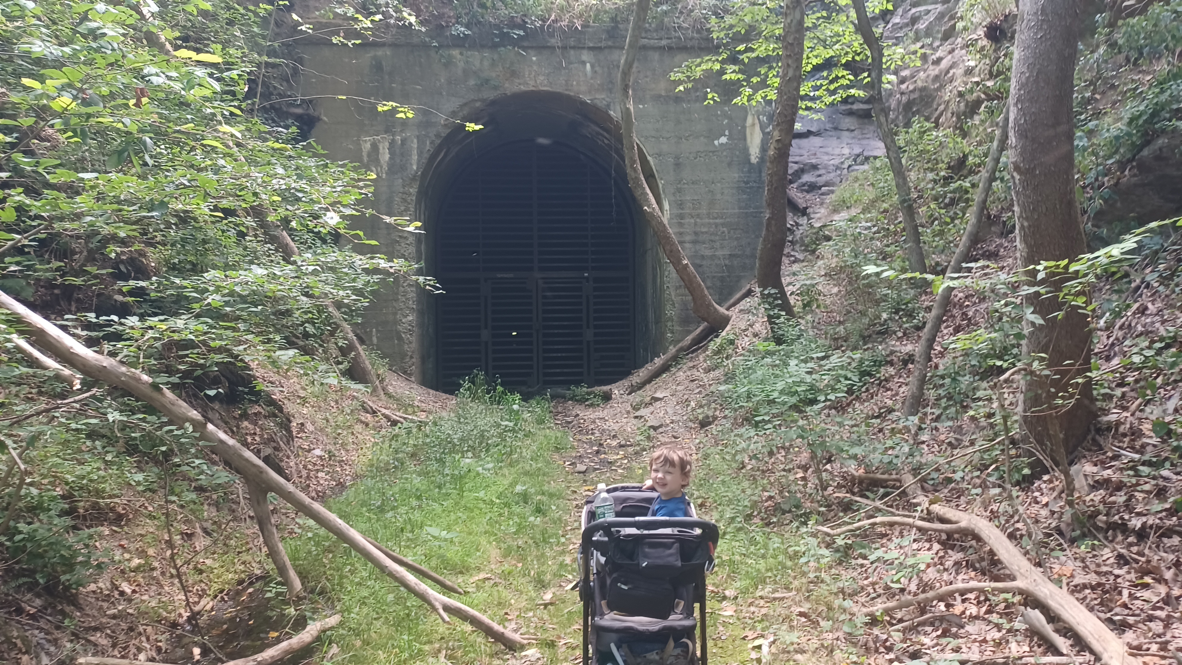
Ahead lies the Indigo Tunnel, a rather long rail tunnel through the geographical formation known as Indigo Neck, closed off to public.
The tunnel was opened in 1904 for the line that was completed in 1906. It was the Western Maryland's longest tunnel enroute to Cumberland, at 4,350 ft.
The Western Maryland was abandoned in 1975 because it duplicated the area served by the Baltimore and Ohio, but I can't help but wonder if this was also due to the many tunnels and bridges that required so much maintenance.

The National Park Service acquired the line, and when trail was finally developed in this section in 2019, the tunnel was excluded for use as a bat hibernaculum, and the rail trail detours to C&O Canal.

As the trail detoured to the bridge to the right, we continued ahead on the undeveloped railroad bed a short distance to the mouth of the tunnel.
The giant grate that blocked the concrete facade could be peered through to see the metal framework holding the tunnel together several feet back.
It would be awesome of this could be opened for the trail, but it's not really a big deal to go around on the canal either. Separating the hibernaculum would be a costly measure, and for not a whole lot of recreational benefit with a clear parallel trail.
The tunnel mouth was the perfect spot for us to get a group shot, since Joe Millionaire and Alyssa would be leaving us soon. We got it and moved on back along the right of way.
We turned left and headed south to the C&O Canal towpath below, and said goodbye to Joe Millionaire and Alyssa who headed back at this point.
The towpath in this next section was upgraded a bit with a new surfacing that had been nicer than what we were walking on before. This is apparently so that it more closely matches the harder surface of the rail trail above, for the cyclists that do that and head down to the towpath.

Pretty soon, we came to the Indigo Neck Campground on the towpath. These campgrounds are every few miles serving hikers and bikers, and are really nicely kept.

We didn't bother stopping to swim yet at this first campground because it was still so early into the hike. We continued on a short distance ahead, and soon reached Lock 57.
Unlike the ones we had seen the previous day, this was one of those higher quality locks like the others on the C&O Canal.
The stone was of fine cut quality, and didn't require the extra concrete facing that the others we had been seeing did. The shape was still about the same, with the lock and drop gate area, and then the bypass flume on the inland side beyond the lock.

Many other canals I have walked are much different from lock to lock how they were laid out. On the Delaware and Hudson Canal for example, the bypass flumes on most every lock were a slightly different configuration. These were all almost identically constructed, at least the ones we've done.

Although greater expenditures were met on this one, it appeared that it still had a cheaper wooden lock house, which is gone today. Only the foundation and chimney remain.

After passing this lock, we weaved around Indigo Neck to the north, and then the west again. The canal was watered a bit through some of this section, and quite pretty.
As we walked, we could hear the whistles from the trains on the former Baltimore and Ohio Railroad across the Potomac, which I pointed out to Ev. At some point, we could barely see trains passing by through trees as they went by. Most of the time, we could hear them, but we couldn't see them at all through the trees.

The trail took us to the west a bit, and then started turning to the north. I watched the slopes to the left closely when we got to near where I thought the other end of the Indigo Tunnel should be.

While in the middle of conversation, I interrupted quickly because I spotted a faint path going up the slope from the other side of the dry bed of the canal.
I wasn't sure if we'd come far enough yet, but I figured we had, and I wanted to see if this was the right spot, so I crossed and ran up.
Sure enough, this was the mouth of the east portal of the tunnel. The area was not well used, and most probably have no clue it is even up there.


Ev stayed below with the others, and I got some photos of the tunnel, including some pretty good then and now compilation images.

It seemed interesting to me that they chose to make the sections of this rail line in the area into a trail, because the amount of rock fall that seemed to cover over the area seemed substantial.
After I got the shots I wanted, I headed back down the same steep path I'd climbed up on to return to the canal towpath. Kirk decided he was going to try to stay up on the railroad bed parallel with us, because it didn't seem like it would be very long before we'd be back onto the railroad bed ahead.
We continued on the route below for just a bit, and then came to another bridge over the canal on the left, similar to the one we had come down on before, which ascended back up to the railroad grade.
We could see Kirk at times walking the grade from the canal, but it was obvious that there were some substantial collapses in the slope along the way.
It took him a while to get through the mess to catch up with us. We waited where the rail trail resumed, where there was an historic marker about past rock slides.

The Cumberland Extension of the railroad is described as having been between Cumberland and a spot on the canal east of Hancock known as "Big Pool".
The sign described that on one occasion in 1970, a derailment resulted in the dumping of tons of Reece's peanut butter cups. The sign even begged the question what became of them.
Carolyn waited in the shade for us at the top of the slope here, then rode along with us for a little bit. She then went ahead for a while as the rest of us walked, Jack played his carbon fiber guitar, and we sang some songs.
The next point of interest in this segment was the crossing of Sideling Hill Creek on a deck girder former rail bridge.
Sideling Hill is a major ridge that continues north into Pennsylvania, and had been an obstacle for both the ill fated South Pennsylvania Railroad and the later Pennsylvania Turnpike.
Sideling Hill Creek marks the boundary between Allegany County and Washington County.

From the middle of the bridge, a view to the right is the C&O Canal's Sieling Hill Aqueduct, completed in 1845.

The 110 foot single span stone arch is one of 11 stone aqueducts on the canal. The Sideling Hill formation continues into West Virginia, and there was a splendid view of it from the rail trail.
We continued on from this pleasant location along the paved Pearre, which is pronounced "Pay REE".
Originally, during the construction of the canal, this settlement was known as Sideling Hill, and workers on the canal, especially because of the complicated work on the aqueduct, were provided from here.
As the canal began to wane, the Western Maryland Railway moved in, and established a station stop on the line.
For a while, a grade crossing just above Lock 56 on the canal, was the western terminus of the rail trail.
We crossed the road, and continued ahead along the backs of some homes, and then soon came to a parking area for the trail. This lot was the former site of the Pearre station.
When the station was established here, the settlement name was changed from Sideling Hill to Pearre in honor of Baltimore accountant George Pearre, because he was affiliated with the railroad.

The last passenger train came through this station stop in 1953, although freight continued till at least 1970.

The railroad in this area hauled rail ties and other freight, but one of the major things specific to the area was the apple industry. One major company hauled over 75,000 apples annually.
Additionally, the line carried livestock and other farm goods. The station and another nearby stock house that only a foundation remains for were part of this industry.
We passed the station site and lot, and there were still a few more houses in the community, on parallel Pearre Road just to the north of us.

Compared to the day before, it was odd to see the occasional car go by, although it was still nearly as secluded as that previous day.

We continued ahead, and the larger Woodmont Road climbed up the hill to the north, while the now unpaved Pearre Road continued ahead parallel with the track bed.
Soon, we came to the historic site of Woodmont Waiting Shed a sort of shelter and flag stop station site.
The Woodmont Rod and Gun Club started here, founded by Rear Admiral Robley Evans after a hunting trip invitation by local Robert Lee Hill.

2,023 acres were purchased, and different breeds of wildlife were raised under direction of Henry Bridges.

The Western Maryland Railway was established here in 1906, abandoned 1975.

In its heyday, Woodmont was visited by Babe Ruth, Gene Tunney, Amos & Andy, and seven US Presidents.
The state of Maryland purchased the tract and named it Woodmont Natural Resources Management Area in 1995.
The historic Woodmont Lodge apparently still stands up on the slope, and I'd have loved to see it, but I didn't know anything about it at the time of this trip.
There is apparently a chair in the Woodmont Lodge that only US Presidents are permitted to sit in.

We entered some better shaded woods ahead, which was quite pleasant, with Pearre Road still parallel with us.

Soon, across the road, there was a sort of stone wall visible on the slope to our left. This was the foundation of the Woodmont School, a one room log Schoolhouse covered in clapboard, built in 1875.

It served the children of the Woodmont and Sideling Hill/Pearre communities of western Washington County. An historic marker on the trail told of what it was just ahead.
I had to of course head over and try to get a good then and now of the site.
Pearre Road moved soon off to the left, and we were in a much more secluded setting. The rai bed went through some dramatic rocks cuts in this next segment, some of which were almost perfectly vertical on the left.

The trail opened up a bit, and we soon crossed over a small bridge across the Long Hollow.

At this point, to the left of the rail bed were the Poly Ponds. Boats from the C&O Canal could pass beneath this rail bridge and enter the Poly Ponds, which were used as sort of a basin for storage and maintenance, just a bit further away from the main canal.
We continued a bit further beyond this point, and were soon parallel with Deneen Road.
I had planned that a point along Deneen Road was going to be our turn around point, but I didn't go to quite as far as I was planning. That will mean that the next hike we do out of Hancock to the east will have to be a bit longer.

Still, we went far enough and did enough side exploring for me to be happy with what we'd done.

Just a little bit after crossing the Long Hollow bridge, there was a little side path that went to the right, down to lock 55 and Guard Lock 6 on the canal, and the former site of Dam #6.
This important spot on the canal is right across the Potomac River from the West Virginia town of Great Cacapon.
This site was the head of navigation on the C&O Canal from 1842 until the final 50 miles were completed in 1850. Lack of funds, in availability of materials, and striking workers were among the problems faced extending the canal Beyond this point.


It was quite an interesting little spot to see.


At the very bottom of the slope, we came to Lock 55 first. Although this lock was completed in 1840, it did not go into service until those last fifty miles were completed in 1850. Foundation ruins of the lock house remain, but nothing else at this point.

The lock was in fine shape with the nice stone material like most of the others through the area. The lock house was probably done more cheaply here.

I'm unclear on exactly how all of the navigation at this area worked. Usually, guard locks were used to get boats out of slack water navigation sections of the canal.
In this area, it seems to be a bit different. I brought two guide books with me, that gave more or less history of each location. Some details were in one but not the other.
In this case, I didn't find a whole lot of explanation, but I assume that boats would travel through the guard lock into the Potomac so that they could reach Great Cacapon.

I've heard that Guard Lock 6 may have at one time been filled with earth, and was excavated by National Park Service, but I'm not totally sure.

The lock was also made of fine cut stone and appeared to be in outstanding condition.
Jack and Sarah went over to the edge of the former dam 6 site. The footing of the north side of the dam was in place, but it no longer spanned the river from this site.
Just as we were reaching this site, Ev fell asleep in his stroller. I parked him over on the grassy berm area and put the brakes on while Jack and Sarah sat and had some lunch or sang some songs or something.

I ran down to the bottom of Guard Lock 6, and then down a path to the Potomac below. There was a good, deep spot, so I took a quick dip.

Even though it was not nearly as hot as the day before, it still felt so much better to cool off like that.
I went back up and took a few photos around the site. I thought I'd had more historic photos of it to get then and nows, but apparently I didn't.
All I had was one historic photo of the old Dam #6 from above, and there was so much vegatation that there wasn't really much to see. After being at the bottom for a bit, I ran back up to the top of the hill and tried to get a shot to emulate the dam site anyway.

After a bit, we were ready to move on, but there was a slight problem with this section.

The canal towpath ahead was officially closed, for reasons I did not know. I was not happy about this, because I didn't travel all this way to miss out on a substantial piece of towpath.

I wanted to have a look and see what it was all about, so we walked ahead anyway.

The Long Hollow bridge, which is a spillway bridge, was the problem with the section.
Spillways were more common on the canals I am familiar with, such as the Morris Canal, Delaware Canal, and Delaware and Raritan Canal. Streams just flowed into the canal, and then over into the river beyond. I hadn't seen any of these yet on the C&O, and apparently, they were not all that common.
Because of the flow of water, the long section needed to be bridged. My experience with such spillways in the past was often that one would have to simply walk across the overflow.


The bridge structure was dipping down in the middle, probably because of some sort of broken bit of wood in the superstructure.

I walked over to make sure it would hold me first, and it was fine, so we just continued.
A little bit after we crossed the spillway, we came to a very nice masonry double spillway structure. Apparently, the area was considered to be prone for overflow enough that even the secondary spillway was necessary. This stone structure was restored by the National Park Service in 1991.
I was so glad to be on the next section ahead. It was so pleasant, quiet, and shady, and there was just no one else coming through on it.


The next point of interest was Lock #56, also known as Sideling Lock or Pearre Lock in later years.

This lock lifted boats 7.7 feet. The wood frame lock house was still standing and in good condition along the towpath.
A canal store also once stood at this lock on the berm side inland. Just a little up from the canal, I understand this is an old collapsed house as well, which may have been canal related.
Although work began on this Lock in 1837, work was halted due to lack of funding, and it was not completed until 1848 or 49.


The fine cut stone lock walls were mostly in good shape, but it appears some concrete repairs were done on the upstream river side.


There was an access down to the left from the canal to the river at this point, so we went down there. Kirk was there waiting for us, and we had a good long break with a final dip in Potomac for this trip.

There was a set of steps down into the river, and so I took Ev down in to cool off with me. The river wasn't at all deep in this area, and the views of the mountains beyond were just stunning.
All of us went in for a dip here, and spent a good amount of time relaxing. I really loved this spot.
Eventually, we moved on and got back on the towpath heading to the west. It wasn't very long before we reached and crossed the Sideling Hill Creek Aqueduct.
The aqueduct had metal railings for safety fitted in such a way that it did not undermine the stone work, and had bits of wood to keep the metal from pressing against the stone. It was rather impressive.


Again, the view to the mountains in West Virginia were just stunning.


Like the other aqueducts, the inland wall that would have held the water was gone so that park vehicles could drive down through the prism, but otherwise, it was in great shape.


We continued on beyond the aqueduct, and it didn't seem like very long before we got to where the rail trail connection was from the right. The improvements to the surfacing were much more apparent this time around.


We continued ahead retracing our steps from earlier. The canal was watered a bit in the segment where the rail trail has to connect with it, and the time of day made it even prettier than it was earlier.

Pretty soon, we reached Lock 57 and the lock house foundation again. I noticed this time that some of the wooden lock door remnants were laying down in the lock.
Carolyn biked along with us for the final leg of the trip here as well.
We made our way around Indigo Neck once again, and past where the bridge connected back up to the rail trail. We then continued on the last leg of the canal back to Little Orleans that we had not hiked earlier.


It wasn't very long and we were back at the boat launch access road in Little Orleans.

We turned to the right, went under the concrete culvert underpass again, and headed up to the cars at the old station site lot.
I was so glad to knock out another substantial section of these trails, and had high hopes to return in just one month to continue on the journey eastbound on both trails. I had a very good two days of two loops directly out of the town of Hancock all ready to go.
Unfortunately, August came and went, and we didn't get back to the canal like I'd wanted to. I didn't want to waste so much of this awesome route on just Winter hikes, and time was running out.
I scheduled the next two days on it for September, with hopes that it would still be warm enough to swim and enjoy it all like we had on this and the previous ones.
Currently, beyond Hancock, I think we can do one loop as a day hike, and then another two day trip using Williamsport as the home base.
No comments:
Post a Comment