
Hike #1617: 8/4/24 Quakertown to South Bethlehem with Steve Sanbeg, Professor John DiFiore, ?, ?, Violet Chen, Robin Deitz, Evan "Joe Millionaire" Van Rossum, Alyssa Lidman, Kirk Rohn, Dan Lurie, Jim "Mr. Buckett" Mathews, Everen, and Mike Piersa

This next trip would bring us back to the Bethlehem Branch of the Reading Railroad, between Quakertown and Bethlehem PA.

The hike was planned to be the annual March on Musikfest hike. I had not been able to bring Ev to the festival the previous two years because his mom will flip out of I do. I decided this time I would just cut out early when we got to the festival and not go, but I'd still have the hike ending at it.
I could have come up with an entirely new hike, but I felt it better to do something enjoyable and stroller friendly, with some swim spots, rather than something otherwise.
This would be the first hike where I could use my new Honda Odyssey as a shuttle vehicle, and it went quite well overall. The only thing that did not go well was trying to figure out the parking situation.

For years doing this event, we had been parking at free locations very close to the festival. When we first started doing the March on Musikfest, we parked at the Brodhead Lot of Lehigh University on the south side. When the regulations changed on that lot, we shifted and started parking at the Martin Tower on the north side. Then, the tower was demolished and parking was shifted to the south side, to Iqor.

I figured it would be fine parking at Iqor again, and actually I saw well before the event that there would be parking there.

Unfortunately, when we all arrived there in the morning, the signs read that no festival parking was allowed. Apparently Iqor is out, and I'm not sure who owns the building now, but it was not permitted to use for parking.
We had to figure something out really quickly.
Mr. Buckett showed up, and I think it was he who checked for some better parking, and found some good free on street parking over near the Museum of Industrial History. This would work out well.

We all shuttled over to this other spot, and then to the south to Quakertown. I chose an old brick yard site on the north side of town as the meeting spot.
I'd been facing all sorts of craziness lately, and stress level was not improving.
After the mess of losing my parked car to an uninsured driver, and all of the nightmare of trying to figure out transportation and such, I went through some more craziness just a couple of days before this hike.

While at work at Hacklebarney State Park, I was cutting brush and a large branch swing back, whacked me across the face, and threw me onto the ground. My nose was bleeding and not looking straight, and I was a bit disoriented, but okay.
I called it quits for the day, and I was sent to Urgent Care.
Urgent Care said I had a concussion, but I needed to go to the Emergency Room to have an MRI done to make certain I had no internal bleeding.


My coworker Judy drove me to the hospital, and I had my MRI, which thankfully revealed there was no further internal bleeding or damage.

It had been a long night, and I was getting grief about driving at all, but I was under no circumstances going to back out of doing this hike.
I was glad that I posted what I did, but it ended up being longer than I'd remembered it would be. It was still another great day to be out anyway.
After getting cars parked on street at I think it was Webster Street, we shuttled south to Richland Township's Brickyard Pond property.
This was a nice spot on a pond that historically was used for the soil material in the brick making process.

I'd not really explored any of the brick yard ponds in the past, so that was something I could slap onto this hike that we'd not done before at the start.
I let Ev out of the stroller right away, and he was keen to walk for quite a while. We went across Heller Road, and then into a small sandy road into a section of old brick yard ponds across from where the municipal park one was.
We headed down to the waterfront, which was quite pretty, and then took on the off road trails to the north a bit. These brought us back out to Heller Road to the north.

The road and sidewalk at this point are actually the route of the Highlands Trail, which I'll get around to doing one of these days in the future as part of that series again.
The trail follows Heller Road to the north, to Pumping Station Road. I'd walked the trail through the woods ahead, but it meanders a lot and is quite bumpy for the stroller, and I wanted to try to get going on more relaxing terrain.
We followed the sidewalk instead along Pumping Station Road just a bit to the west, and then turned to the right into Veterans Park. A nice paved path led right through the middle of it, and then turned to the noth parallel with the former Bethlehem Branch of the Reading Railroad, which becomes the rail trail a short distance ahead to the north.

The first time I had hiked this line would have been about 17 years earlier, where we went from Quakertown to Bingen, with the idea that we were going to Bethlehem, but didn't make it. It had been really a rough one. The tracks were still in then.
The line was built as the North Pennsylvania Railroad in the 1850s, and extended north from the Philadelphia area. It was leased to the Philadelphia and Reading in 1879. The original plan was to extend it all the way to Waverly New York.

Passenger service continued to Bethlehem until 1981 when it was scaled back. The rails remained in place after that for many years, but removal began around 2011 when construction began on Saucon Rail Trail at the north end. Today, it is trail most of the way from Quakertown to Bethlehem.
Talks of reactivating passenger service to Quakertown have persisted over the years, but never got farther than discussion.
A recent government study recommended reactivation of the entire branch to Bethlehem. The right of way was double tracked all the way through, so there is room for rail with trail, although complicated.


Events such as Musikfest, Celtic Classic, and year round concerts and casino suggest such a reactivation could be beneficial to the area.
For the time being, passenger service is only available to Lansdale and to Doylestown via the branch.
Since it was always double tracked, and those double tracks were still in place when I first hiked it, there was definitely room for rail with trail. I'd imagine with fast commuter trains, it could be problematic though.
Joe Millionaire busted out an "Even More Jesus Maple Syrup Bourbon Barrel aged brew around this point, which I was given a taste of, and it was absolutely amazing.

This section of the trail trail is now known as the Upper Bucks Rail Trail. We paralleled the tracks for a bit, which still had flat bed cars parked on it parallel with the park.
People have argued it on the facebook posts, but there are trees growing through these things, and I don't think they've moved at all probably since 2007. When we did that hike back then, and on subsequent hikes through here, we walked on top of the derelict rail cars in order to get to the next section ahead. It looks to me like the same ones that have been there all along.


The Highlands Trail came out of the woods to our right as we continued ahead, and the northbound trail continues on the rail bed ahead. It actually has two routes, one of which goes to Nockamixon State Park, the other goes up through to Bethlehem and then east to Easton and down the Delaware Canal.


We soon crossed California Road. This might at one time have been a station stop. The settlement was known as California, historically.

Here, the rail trail moves from parallel with the tracks onto the track bed itself. It enters a dark, shady cut to the north of California Road.
The right of way shifted from northwest to north through the cut, along some of the headwaters of the Tohickon Creek I think it was, and then to East Cherry Road at the little settlement of Shelly.
This was a small station stop along the line, and there used to be a store and restaurant in a brick building to the west of the crossing, which I'd never known. I figured it was always just a well-to-do house.

From here, we continued to the north, across a couple of utility clearings in wetlands, and then across North Mine Road, more wetlands, and then into a deep cut.
As we approached the underpass below Springfield Street, we started the long boardwalk section where the rail right of way becomes inundated with water.
This was always a messy spot, so it was interesting to see how they went about getting the trail through on it. The railroad ties and some spike plates are still visible down below in the water from the edge of the boardwalk. I let Ev down to walk on this because it's so interesting.

This deep cut we passed through I understand is the border between the watersheds of the Lehigh, Delaware, and Schuylkill.

Just to the south of this cut, streams flow southwest to the Perkiomen Creek, which flows into the Schuylkill. The Tohickon flows into the Delaware from just to the southeast, and the Laurel Run flows into the Saucon Creek, and then the Lehigh to the north.
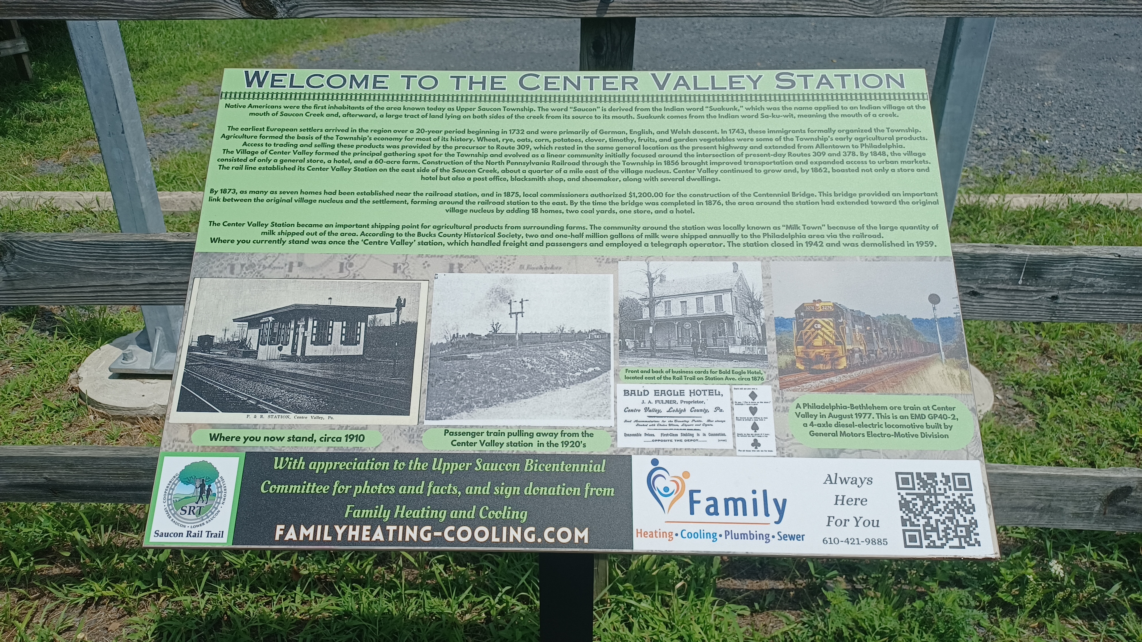
It was a good shady spot to take a little break. We continued on and headed to Station Road in Coopersburg, where the station used to stand.
Both this location and Shelly station site had good historic markers that had not been in place the previous time I'd been there.
I used some of the historic photos to set up then and now compilations at the site before moving on.

Also, Coopersburg was a good opportunity for a lunch break. When I'd hiked this in the past, we would go to the left out to Rt 309 to get lunch.
Ev gets somewhat picky, but I knew he would probably eat Burger King, and there had been one just down the street a short distance. There was also a good liquor store we liked.
Unfortunately, this time we were not in luch at all. I was very unhappy to see that the Burger King had closed down. Furniture was all still inside, but it was shuttered. It's sad that so many Burger Kings have been failing, because honestly, I think they have the best burgers of the available fast food joints in the area. Wendy's has been coming up as the most popular, but as per the taste test, I think that Burger King still has them beat for the best tasting burger patty.
Sadly, Link Beverages was also closed when we got there. It does not open until later on Sundays in Pennsylvania, so we were out of luck there too. I suppose the last few times I had been in the area, it was on night hikes where we did not have this issue.

We ended up going over to the Turkey Hill Mini mart to get some food with not much else available at this time, and took a little break out front. I was able to get some stuff inside to snack on before pushing ahead.
We walked back up toward the former station site, and I did another then and now of a former hotel building on the left side near the former tracks. Historically, this was the Baldwin House, and now it is a strip club known as Silhouettes. Years ago, I remember hiking through here and our friend Guillermo went inside, while we continued ahead. When I noticed he was missing, I had to go back and get him. I found him inside drinking a beer, sitting and chatting with a girl with nothing but a thong bottom on.

On that hike, the right of way ahead was in rough shape, and we had to parallel through adjacent farm lands and golf courses, and we got stung a lot by yellow jackets. This was way easier, clear and fast heading north.
We headed north, crossed Landis Street, then passed over Jacoby Road, and then over a parking lot access to some sort of electronics place.
Passer Road and Flint Hill Road were next, and then we came to Station Road in Centre Valley, another former station stop. I don't think I got any then and now compilations at this spot, but I should head back to do them in the near future.

We continued north, and the trail took us through Upper Saucon Community Park. In this park, the trail leaves the railroad right of way and heads into the park. I'd always followed the official route through this in the past, but this time we took a slightly different path since there are a couple of ways through, just to change things up a bit.
There were some hilarious conversations between the group and Mr. Buckett, which is to be expected, making every step that much more entertaining.
We headed along the pathway through the park, which leads through a tunnel beneath the Preston Lane, and then ascends again soon to re-join the railroad bed on the other side.

We continued north across Landis Mill Road, and it is always interesting to pass through the neighborhoods where they made them put up enormous fences to block any views from or to the trail.
Much of the entire distance of the day was lined with giant Paulownia trees.
These strange trees produce leaves that can be over 3 ft across. Native to Asia, and sometimes called Empress Tree, it is so named for Anna Paulowna, once daughter of the czar of Russia.
We continued, reached and crossed Spring Valley Road, and continued out toward Bingen Road.
This was another station site of the past. I had some historic shots I wanted to try to get here, but the foliage wasn't working for getting them well, so I decided to skip it again this time. I have some others I'd gotten here in the past anyway.
We paused for a break here because there was a water fountain with multiple levels, trash cans, and such. At this point, we were getting closer to Hellertown.

After crossing Bingen Road, we made our way east a bit, and soon made the first crossing of the Saucon Creek, which is always pretty. A little way beyond that, we reached Old Mill Road, turned to the north, crossed Meadows Road, and crossed Saucon Creek again, with a lovely little dam visible from the bridge.
We continued ahead into Hellertown, and the two newcomers to the hikes left us early because they wanted to get to Musikfest I think before heading home, and it was running a bit late.

We stopped for a break at Water Street and stopped at the PA House on the other side of a small stream.

I ran across the street to see if the beer distributor had anything good, but I don't recall there being really anything of interest to me.
Once we were done at the place, we continued up the Saucon Rail Trail through town, along Water Street Park, but then turned to the left when we got to the former site of the Saucon Ironworks. An informal side path led down closer to the Saucon Creek, and by the giant cinder piles from the site.
The Saucon Ironworks was established one year after the end of the Civil War, in 1866. It remained under that name until it was taken over by the Thomas Iron Company in 1884.

The works provided pig iron for years, but when Bethlehem Iron Company ended and Bethlehem Steel began, it took away the business. The Saucon site of Thomas Ironworks closed in 1920.
 |
| 1860 Smith, Gallup & Co map |
We continued through this unshaded moonscape for a bit, and then continued on a trail into the woods, a bit of which passes over a former rail line that served the site. We then continued along a good path along the Saucon Creek until we found a pleasant spot to go and take a dip.
The day had been long, and I knew it was going to seem like too long before we'd actually get in the creek, but it was nice when it finally happened.
We spent a good amount of time relaxing there, and then continued along the path north until we came out on Seidersville Road. There, we turned left and reached the abandoned Seidersville Road bridge over the Saucon Creek.
We crossed the bridge, which was still easy to get the stroller through, with good views of the creek. Some components of the bridge, which has been closed well over a decade, because we'd been using it for so long, have concrete filled into it.
On the other side, there is an old spring house on the right side. We used to be able to walk right down into it, but it is now fenced off securely making it impossible to enter.

The path to the right of it provides a view of the inside of it anyway.
I figured it was a bit of a gamble, but we continued to the right on the trail that follows the Saucon Creek to the north. There was a time that this trail was really easy to follow through, but this time proved not to be so. We got through anyway.
Sometimes, I don't consider the hardships of the trails because I didn't have any consideration for strollers the first several times I'd done them.

This one was worse, because after we moved on a bit, there were trees that had fallen over the way.

I considered going uphill and making my way through fields toward the next road, but the group helped me to get Ev over the fallen logs and along the roughest part of this trail following the creek upstream.
There was a second little spring house on the section, and then a steep slope that was probably the toughest part of the entire hike.
When we got through that, some of the trail along the creek was alright to follow. We continued along this, and passed the former site of a dam.

When fields began to open up to the left, I recognized them as having been corn fields in the past. They were now just sort of fallow pastures. We were able to get up into them, and then there were some mowed trails passing around through them.
I'm not sure what these are all about, but I assume it must belong to some adjacent farm property. We continued around the edge of these fields, and when we got to the closest point to nearby William Street, I cut the stroller off of the path and toward the road. It didn't require too great a push to get it through and out to the road. We turned right and continued.

We turned right onto College Drive, and continued ahead, then passed beneath Interstate 78 and passed beneath to reach some of the fields for Saucon Park.
We turned right into some ball fields, then left along the edge to the old reflection pools on a tributary of the stream ahead.
Saucon Park opened July 4, 1919, with a speech by Mayor Archibald Johnston. The park is 90 acres following the Saucon Creek. Within the first year, over 10,000 people visited the park. The area follows some of the early 1900s Olmstead Bros style layouts with beautifying aspects that accentuate the natural features like the creek and the hills.

We continued past the ponds, then across a great little foot bridge to a picnic ground. Here, we had to turn right onto a narrow paved path. This ended very quickly, but we continued uphill through the grass and into a parking lot. We continued straight from there and onto Auburn Street. We continued east on Auburn a short distance, and then came to the next bit of access to the rail bed, which at this point is known as the South Bethlehem Greenway.
We turned left, through part of what had been the start of the rail yards from Hellertown up to Bethlehem.

There is a very tall, railroad related tower ahead along the right of way, which has some sort of nest up in the top of it, supposedly eagle.

We next crossed a high bridge over Millside Drive and the Saucon Creek. Beyond that, the trail went on part of the rail grades to the left, while active tracks started up again as part of an active yard to the right. It is blocked by chain link, but we used to be able to go through, and would walk on top of the cars years ago.
We passed soon beneath Lynn Avenue, as the right of way shifted to the west. Another set of tracks came close to the north of us, another former Bethlehem Steel spur.
Next, we went under Fourth Street, and then parallel to the skate park. We continued to the west along Daly Avenue with good views of Bethlehem Steel, now Wind Creek Casino, along the way.
While walking this section, we caught up with Mike Piersa, who had just gotten off of work from the National Museum of Industrial History, and he walked with us the rest of the way. It's always nice to catch up and chat with him a bit. I had just seen him the week prior, as I was asked to be a guest orator during a special rail fan trip in some RDC Budd Deisel cars on the former Lehigh Valley Railroad and Central Railroad of New Jersey out of Nesquehoning PA. So we still had some stuff to talk about, and I wish I'd had some more time.

We continued across Third Street, and then Hayes Street, as we made our way into the busier part of the town.

We continued on across Buchanan, Piers, Fillmore, Polk, Taylor, Webster, Adams, and New Streets into town, and soon approached where we had left our cars. Jim DeLotto was hoping to meet up with us, but it was getting really late. While I would have loved to hang around for a bit more, I knew I would get shit for it really badly if I didn't take the opportunity to get out when I did.
I had the opportunity for a ride back with a car seat as long as Robin was there, so I had to unfortunately make an abrupt exit or I'd have bigger problems.

Much of the rest of the group weren't too tired, and so they continued on into the fest, while some were on our way back to the end.
It really isn't too big a deal for me, because for me it's always been more about the hiking than anything else anyway. Pushing Ev through Musikfest while tired, with a stroller, was probably not something to be doing when we had already gone so far over the planned mileage, probably close to twenty miles at this point. It was good to get out when I did.

When we got back to the brick yard lot, it was just starting to get dark, and it was a pleasant back road drive through the hills of Bucks and Northampton Counties on the way home.
No comments:
Post a Comment