
Hike #1613: 7/7/24 Stuckey Pond to Turn Farm with Daniel Lurie, Daniel Lurie Jr, Joe Pinto, Violet Chen, Professor John DiFiore, Jenny Tull, Galya, Brittany Weider, Diane Reider, Justin Gurbisz, Steve Sanbeg, and Everen


This next hike would be a point to point mostly within Delaware Water Gap National Recreation Area, between the Turn Farm trailhead on the McDade National Recreation Trail and Stuckey Pond.
After the long previous weekend so far from home, I figured it would be nice to do something somewhat closer to home, in areas I'm more familiar with and have always loved.
The Delaware Water Gap NRA has been property I've been exploring with my grandfather since I was only three years old.

In adulthood, I had started a series of hikes to cover the entire "Pocono Rim", meaning the formation of high land above the Delaware River above the Delaware River toward Port Jervis.

I started this series probably around 2006, starting just below the gap itself and up the Slateford Glen. Over months, with a couple of hikes in the series per year, we explored every tributary that flowed into the Delaware River heading upstream.
We finally did pretty much the last one in the series in 2013, Justin's first hike with the group.
Throughout this series, we came across countless off trail vistas, hidden waterfalls, and interesting back woods routes that most wouldn't consider doing.

Even though I considered the series to be pretty much complete, there is always something more to do, and there are certainly things here and that that warrant more exploration.

I tried to put together a route that featured swim spots, places I'd visited already and loved, places I'd not been in over a decade, as well as a little new stuff.
The meeting point at the Turn Farm was something I had used maybe once before, on my first hike that featured the McDade Trail. The trail wasn't complete up to the National Park Service headquarters at the time, and so it involved some back road walking on the River Road, and the trail started back up at Turn Farm.

Now, the trail was completely, and maybe this was to be the main trail, but it is now a spur that goes to the farm, and I'd not been on it since completed.

On the way out there in the morning, I saw Joe Pinto behind me. We pulled into Hialeah Picnic Area on the way because I wanted to do a brief video on the hidden cemetery at the location, featuring the grave of young Rhoda Shoemaker. It seems the National Park Service wants to somewhat hide that this and other cemeteries even exist, and this one had been a family plot.
I couldn't find the grave this time; I was early, so I figured we'd be okay looking for it, but I figured I'd have to come back later and find it (I did get to it after the hike).

We headed to Turn Farm trailhead, and figured out how we were going to handle the shuttling.

Myself and one other car went to the starting point from here, which was a rather easy commute up to Bushkill, and then up onto Milford Road and over to Stuckis Road, which led to Stuckey Pond.
This was one of those locations that has had a few different names, but not sure which one exactly is accurate. The old NY NJ Trail Conference maps called this Sunny Hill Lake, but in later years was named Stuckey Pond.
I had done one of the Pocono Rim hikes through here in the past, using the gravel access road, and then bushwhacked down the outflow tributary known as Mill Creek. It's a beautiful, secluded stream with just a few tiny cascades on it, but quite nice.

I'm not sure the history of the pond, but certainly it wasn't something that was just built when the federal government took over the land.

On the old trail conference maps, there was an unmarked trail that went all the way around it, but there's really nothing there now except for a car top boat launch.
We parked out of the way to the left of the road when we got there, and there was only one other car with a guy hanging out.
I walked over to the pond and waded in right away, but it was definitely not something that looked inviting to swim in, and definitely not while sober.

We made our way from the pond onto the gravel road and walked it in the direction we had come, back out toward the Milford Road. It was a pleasant walk, even though we'd already just walked it.

We got to the main paved road, which is quite wide. It has gone through a whole lot of improvements over the past several years. I have a theory that this was done in order to replace current Rt 209, which passes completely through the federal land.
National Park Service has full jurisdiction over 209 from Bushkill up to Milford, and so it makes sense that for larger trucks and such, they would need to have an alternate route, just outside of the national park property, to get through.

I figure that's why this road has been made so much wider.

We had a good shoulder to follow along it for a short distance to the west.
On the left, with no signs I don't believe, the unpaved Asher Lane went off to the left. There were no signs reading no trespassing or private property, and Google Maps showed this road going through, so I figured at the last moment that maybe we'd follow this. It would take us through to the road I wanted to get to, Big Egypt Road.
It was a little unnerving walking into this odd road, but the fact that nothing said to stay out made me feel a little better.

The lane had a lot of stuff lined up all through it. There was a small home on the left, with several antique cars sitting decaying around the outside of it.

Joe made a funny remark that he had come back to visit from his home in Kentucky, and that I'd brought him to Kentucky.
The road was interesting, but I was glad to be past this portion of it. There was a much better kept home ahead on the road, and a nice view to the west over a meadow as we started to steeply head downhill on the road. We then reached Big Egypt Road, which had a few residences on it, and turned left.
The road used to be a through route from Milford Road down to the settlement of Egypt Mills close to the Delaware River on Rt 209. I had hiked through on it twice before in the past, last in 2009.

The first bit of it is still open to vehicles, but hardly has any on it. We meandered through woods once we got through the national park boundary, and passed some nice rocky outcrops.

There was a big open area that looks like it's used for municipal or federal gravel or something on the right, and then some wetlands. I fell behind some of the group eating some wine berries.
Ev loved the Japanese Wineberry more last year, and this year he still had little interest in eating any. He was more excited about mulberries when they were out earlier.
There were a couple of people in the area walking their dogs and such, and we paused to say hello.

Apparently, the wetlands along this road were much more substantial until more recent years because the national park service removed some of the earthen dams associated with them.

The initiative to turn the Delaware Water Gap National Recreation Area into Delaware Water Gap National Park and Preserve has been a major push lately, but I haven't been sold on it being any kind of a benefit. It is still national park service, and it will not effect the budget in any way I understand.
The big red flags for me are in the verbiage stating that there will be transition from forest to meadow land, which means logging, and the fact that they claimed they couldn't make more money being a national recreation area.

I called out on that the budge of Gateway National Recreation Area, which includes Sandy Hook in New Jersey, has a hugely larger budget than the Water Gap.

I wondered if they would look to log this property under that plan.
Big Egypt Road went along the north side of a wetland known as Whittaker's Pond, and then continued on along the south side of Landis Lake, which is a longer body of water.
The older maps called this Big Egypt Lake, but I've seen Landis as well.
The entire area of wetlands was quite beautiful, and the road could be driven almost to the end of the Landis Lake section.

We got to the lake spillway, and I chose not to try to go into it at this point. Big Egypt Road continues abandoned downhill beside the stream that flows out of it, which is a tributary of Toms Creek.

The old road was always nice in the past, with large wooden railings that surprisingly haven't rotted away despite having been closed for probably over thirty years.
This time, it was badly grown in. We could still hike it for the most part easily, but it was just a sort of single track path width, with encroaching vegetation.
Just ahead, it got a bit worse. Where the tributary used to pass beneath the road via pipes or culvert, it was completely washed out. I had to have the others help me get down and back up on the other side to get through. The occasional down tree also required some lifting over.

We continued along the road for a little bit more, and then came to where the road crossed the stream again, and again the bridge was missing.

This time, I think we could see some of the pipes from the road washed downstream to the right. There was no earth where the stream flowed, and only the wooden guard rails were in place over the missing bridge site.

Again, I had to get the others to help me carry Ev in his stroller down and up through the washout, and then continued on the road ahead.
In a short bit, we came to a point where a waterfall comes into view on the right side of the road, where the stream dips down dramatically. There are a few slide falls in this vicinity. I had climbed up these twice in 2009 with my late best buddy Kyle Zalinsky, and I remember him pulling me up to the top of the upper falls when I started sliding back down.


There was barely any water going over it on this day. Additionally, where the falls had been in pretty plain view from the road, it was now grown in and barely visible.

There was a bit of an opening in the trees, sometimes known as a "window view", out over the glen the stream flowed through.
Big Egypt Road continued downhill somewhat more steeply, but far more gradual than the stream. It weaved back and forth, and there was still only a basic single track path remaining in it.
I had considered trying to see some of the other falls, but there was no sense in trying to go down when there was basically no water flowing over them.
The road continued to weave back and forth a bit, and it got to be quite a bit tougher to walk as we approached the bottom of the slope.
We came to the intersection with Egypt Mills Road, the predecessor to Route 209, and turned to the right to get to the Toms Creek Picnic Area on the right.


Dan and Dan Jr, as well as Brittany were all there waiting for us as they had all run a bit late.

I let Ev out of the stroller, and we all had a nice break in the picnic grounds.
I had been coming here for quite some time, but I never really looked too far into the history of it. I knew there was stuff at the site, but I didn't really have a way of knowing what was where.
I have my books on the region, and I'm a member of enough groups that cover it, so going into this, I prepared some information, and found some historic photographs.
Probably the most helpful of all in this endeavor was Jennifer Palmer of the National Park Service, an excellent historian I met from when I did the community roundtable on historic buildings with NPS.


Jennifer had posted several historic photos of the Egypt Mills area, and so while everyone was taking a break, I ran around and tried to figure out just where everything was.

I started by running over to the creek itself and checking out a dam ruin that still stuck a bit into the creek.
The area was settled by William Nyce in 1776, and his family farmed and operated mills at the location until 1889. The settlement was so named because of the biblical story of Joseph in Egypt, where his brothers went to seek bread and nourishment during time of famine.
Nyce and his three sons all operated mills on the creek here. There were no other such mills in the area at the time, and so many traveled and settled close by to purchase flour and cornmeal. As such, the analogy to Joseph and Egypt was a pretty good one.


The youngest son, Jacob, came to be owner of the mill, and he also operated a store and served as the first postmaster. A bit later, as school was built here. A blacksmith shop was also located here.

The oldest son, John, established a saw mill a little bit further up the creek and expanded on the business.
James E. Nyce, great grandson of William, finally sold the property out of the family in 1889.
The Egypt Mills Club, a group of ardent outdoorsmen, purchased and operated the property starting in 1901. I'm not sure about the history of the big building that served the club, if it was something that had been built

The property was sold to the federal government in 1973 as an addition to the Tocks Island Dam project, and all buildings on the property were demolished.
I had so many photos saved, and trying to figure out what each of them were was just tough. I didn't have much of a clue.
There was a large old farm house, and then there were all sorts of other buildings I didn't know how to locate. The one that I thought I might be able to figure out was the club building.
It seems like the club might have been an historic Nyce family farmhouse extended upon for the club purposes. I'm still not sure just yet.

It looked to me, based on historic aerial images, that the building might be the very back of the parking area now. Ev played around loaded up wooden bumpers at parking spaces with acorns and such, so I took a run along the perimeter of the fields.

There was one historic photo that showed the club building with a stone arch bridge, and I'd heard that was still in place.

It was a sort of early 1900s stone arch, which spanned what I believe was originally one of the mill races. It fed into a sort of pond on the southeast side of the road, which looked to be some sort of recreation area.
The photo showed a large Sycamore tree growing off of the edge of the stone arch, and I saw one on the other side of Egypt Mills Road. I headed over, got off of the road through the weeds, and then hooted with joy when I found that this stone arch was still standing!

Not only that, I could see in the background the clubhouse building. This was my anchor point to the past from which I could set up an entire series of photos, knowing exactly where the building would have stood.

It was out in the grass between the two entrances to the Toms Creek picnic area. There are no foundations there today, but using the stone arch as the control point made it obvious.
From there, I ran along and got a couple more shots. I got into the woods and walked around the berm of what would have been the pond shown in the other images, but I couldn't figure all of that out yet. The angles of the buildings and such require a little more research, and it is best done during leafless season there. I'd have to come back for more.

Very happy, I came back to the parking lot where everyone was waiting and retrieved the stroller. Ev continued running around like a maniac and stuck by Steve a lot of the time, except as we first left. He's getting so fast running, and I shouted at him to stop, but he ran right into Egypt Mills Road. Thankfully, this is not at all a busy road, but it is wide enough that cars move along quickly.
I try to tell him never to run into roads, always look both ways, but he gets all excited. Sometimes, there's no way of getting him back close to me in time. He didn't want to get back in the stroller, but after that incident, he had to learn the hard way. No more walking for him for a bit until we were away from roads.
I got a couple more shots of the former club building site as we walked away. The site that I assume would have been the school had to be somewhere around here as well, but I'm not at all sure where.
We continued on Egypt Mills Road past the intersection with abandoned Big Egypt Road again, and continued to the east out to Rt 209. We walked up 209 just a short distance, and had to figure out a way into the fields to cut over to McDade Trail.

The steep, sheer shale cliffs of the Pocono Rim were in plain view in this area to our left, and quite pretty. We had to continue up 209 past the first field and near the entry to the second. There, I could push the stroller down just barely and into the edge of the crop fields.
From there, we could just push on out to the McDade Trail along the south side of the fields. I should have just turned right on 209 to where the trail comes right up alongside of it and it would have been easier.

The trail weaves into the woods briefly, and then crosses Toms Creek on a footbridge that is right next to the highway bridge, then heads back over near the edge of the Delaware River again.

We continued pleasantly along field edges, and made our way to the Valley View area where there is a camping site for the canoe groups. We paused and took a dip in the Delaware.
It was a pleasant stop, and we continued on to the west, up to the Bushkill Boat Launch area. This was once a little motel place, and some of the steps and such along the loop roads may be left over from the days when this was a riverside overnight establishment.

I had planned to take another dip in the Delaware as soon as we got to the boat launch, but there was a park police car just sitting there as we went by, so I chose not to do anything.
The trail made its way up close to Rt 209 for a bit again, passed a ranger residence home, which I understand had another old cemetery in the woods next to it that I've never seen, and then it weaved back down through woods to the north side of field edges. This section also passes near to another abandoned home that was owned by a member of the Turn Family who moved away.

We continued along these field edges, then into one more swath of woods before emerging on Rt 209 again in Bushkill.
This was once a rather large community, with the Peters House building that used to be on the south side, and a whole line of buildings and mill on the north. Today, the only thing remaining there is Marluca's a pizza place and deli that occupies the old Turn General Store and Tinsmith shop.
The building is two distinct sections from different time periods. The rear section is the original tinsmith shop dating back to 1837, and the front section dates to about 1916. I'm told some of the tinsmith shop, or maybe all of it, is no longer in place.

It is named for local farming family, the Turns, who owned and operated the store, the same family that owned the farm where we had parked for the end point of the hike.
It was Deli Depot in the 1990s, but the store fell into disrepair and closed in the early 2000s for a time. I used to stop in this place with my grandfather years ago, and then when I started dating my ex Cathy in 1999. It was sad when it closed, and I had always thought it was another of those national park service owned buildings that would just be demolished by neglect.

This was not the case; the building was never owned by NPS. It has remained privately owned, and the current owners tell me that they NPS actually likes them because there's nothing else out there where they can stop for lunch!
It was reopened as Roost Deli, and now Marluca's.
The area was once the center of commerce in Bushkill, where roads came together along the Delaware, from the ferry, and from the mountains, and the railroad station on the Delaware Valley Railroad stood directly behind the store.

Talk of extending a railroad from Stroudsburg to Port Jervis started back in the 1850s, but it wasn't until 1901 that a line finally pierced the wild upper Delaware valley to this point.
The line served both logging and tourism interests to hotels and sites such as Bushkill Falls but could not compete with the automobile. Passenger service ended in 1927, and freight in 1938.
Amazingly, the section of the Delaware River from Bushkill to Matamoras is the only part of the entire main river that never had any canal or railroad along it.

We had a really nice lunch stop at Marluca's, and sat inside where it was so much cooler than out.
I got a sub sandwich to split with Ev, but I recall some of the group also got pizza they couldn't finish, so he ended up having some of that as well.
When we were all ready to go, and I had gotten some 19 crimes unrated wine or something like that out, we were ready to move on.
We crossed over the Bushkill Creek on Rt 209. It looks like there were plans to build a footbridge for McDade Trail, because something was graded to either side, but abruptly ends.

Brittany and I used that path briefly to head down and take a dip before moving on, because we wouldn't be passing anything for a little while.
Once across, the trail took us further into the woods, away from 209.
My plan for this time was to try to follow one of the old roads over the Hogback Mountain to the south.
I had hiked only a couple of years ago over the Hogback Mountain on the very old River Road alignment from back in the day. it had been a really tough route.

Most of it was pretty easy, but it's gotten worse over the years with down trees and such.
On that hike, we went up through the Hogback Mountain, and many trees looked to have been intentionally dropped over the road route down to the Freeman Tract Road, making it extremely difficult hiking. We ended up having to bushwhack quite a lot to get through, and I lost a pair of sunglasses up there.
This was tough just on foot, so there was no way I wanted to do that with the stroller. I knew of another old road that use to go over the Hogback out near Blaufarb's Pond, which I also considered for a side trip because it goes out near what is supposed to be an enormous Heron rookery.

Well, first I could not find where the road turned off at all. We continued on the McDade Trail a bit, and the spot was not at all obvious. I should have taken a hint from that not to try this, but I figured it would be easy.
We had to backtrack a bit, but we found where the road had turned. I was able to push Ev through most of it, but it did get tougher. There were some down trees, but the road grade itself was doable. Going uphill over the Hogback was rough, but we pushed through.
We came to a point where there was a fork in the road. I was not sure which way to go and was second guessing myself.

If we wanted to go through near to Blaufarb's Pond, we should have gone more to the right, but I got to second guessing myself, and we went to the left.
This was the old main road we had done before. I had not recognized it, plus I did some off trail stuff in this area before, so I might have missed this spot previously.
Either way, we ended up exactly on the road I did not want to end up on.
I had to pay close attention to where I was walking, so I didn't quite realize we had made the wrong turn until it was quite too late. I just hoped that maybe someone had come through and maybe cleared some of the road since the last visit.

When I knew we were going the wrong way, and I could see the trees fallen over the road bed ahead, at the very top of the Hogback slowly descending toward the Delaware, I knew we had to get out of there.
We started going over to the right through the woods, along a slope on a deer trail, which wasn't too terrible. The slope to the right was pretty much too difficult to be going down, so we didn't bother trying yet.
I knew at some point, if there was no good way through that this was going to have to be a bushwhack down.

We kept on this path, and tried getting back over to the road at one point, but trying to get through that was futile. We had to get back in the woods.
While on this path, we hit a nest of yellow jackets. The group started carrying the stroller for me in this stretch, especially Dan and Jr, while I was holding Ev. We ran to get away, and only Justin got stung out of everyone in the group.
I'm scared to death of Ev getting stung because he's never been stung by anything before, and I don't want his first time to be in the middle of nowhere just in case of emergency.
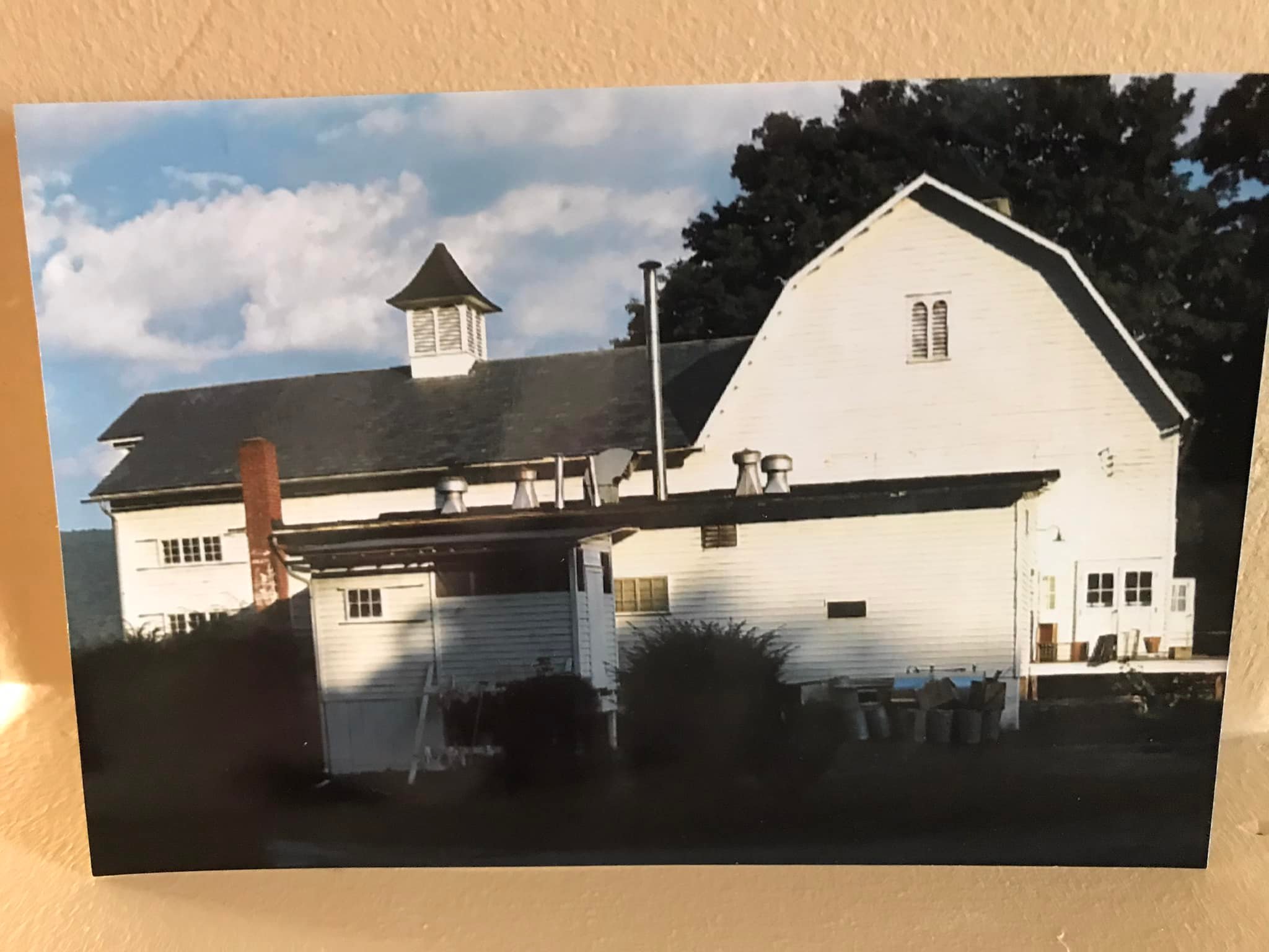 |
| Possibly 1967 John Turn Farm by Bob Wilson Ministerium Curve |
Some of the group went ahead to see if there was any better way down, but they didn't really find anything, and I was getting desperate to get out of there.
At this point, Dan disappeared, and the others were all ahead of me except Dan Jr. He, and Ev and I were the only ones, and I knew we had to get out.
The three of us started heading down the slope of the Hogback to the south, over crummy terrain, but there was a bit of a cleft in the slope that allowed for more reasonable passage. Dan Jr helped me to lift the stroller over every log along the way, and it was a little rough, but soon I could see the Freeman Tract Road just below us. Once we were there, we were good.
We carefully made our way down, and then came out to the road. I shared some of my remaining water with Dan Jr. He wasn't carrying any with him, so he needed something.

I thanked him for being there for me, because this would have been a night mare to get down alone, and he slowly moved on ahead down Freeman Tract Road westward.
I waited up for a bit for the rest of the group when I could see them making their way onto the road.
We all moved on down the road slowly, and I was getting desperate for water. I wouldn't drink the remainder of what I had in one of the bottles because I wanted to make sure Ev had something.
I found two juice boxes he had, and he wouldn't drink the water. Fortunately, he drank those and I could have the water, and that got me through to the Owens Spring House.

I'd been past this spring house before, but never drank from it. I'm not sure how good the water was, but I didn't care at this point. I was far too thirsty. I filled my bottle and chugged it twice.
I do believe I got giardia from it, because I had diarrhea from a couple days for a few weeks after this, but I needed to lose weight anyway.
The McDade Trail came down from the right after a bit, crossed Freeman Tract Road, and then continued downstream. We all turned onto that, although the group tried to take the road thinking it would be easier. I saved them some serious uphill if they'd done that.

It was a pleasant walk from there back to the turn of for the farmstead area.
Today, the site of the barn is the Turn Farm trailhead for the McDade Trail, and the smokehouse from the property is the only extant structure. We saw that on our right. Foundations can be found, including those from this barn behind the restroom facility.
Originally the DeWitt Farm barn, John DeWitt came here from Esopus NY and settled on some 500 acres. He was a blacksmith by trade, who set up a shop on the property.

The property was sold to John Turn in the early 1800s, and remained in the family until 1945 when it was sold by the family to the Evangelical Lutheran Church, which established Camp Ministerium. It was sold to the federal government, as it was to be inundated by the waters of the Tocks Island Dam project, in 1975. That plan was defunct in 1979, and officially deauthorized by 1992.
It is felt by many that the historic relevance of the site was downplayed in order to justify its demolition. The homestead might have been built in the 1700s rather than early 1800s as claimed.
As we were getting ready to go and everyone was resting, Ev tried to weasel his way to sitting right between Brittany and Galya. Already a lady's man.
We got a ride back to my car, and headed on our way home, with a stop to get my video at Hialeah on the way. I got stuck in some of the Rt 80 crazy traffic through the gap, but otherwise, it was a good ending to the day.
Dan and Dan Jr reconnected and got an Uber back. Dan Jr was badly dehydrated and got sick, but everyone recovered well. It had been a bit harder day in some aspects than I was planning on, but overall good.
No comments:
Post a Comment