

Hike #1614: 7/14/24 Ringwood to Oakland with Dan Lurie, Jenny Tull, Justin Gurbisz, Professor John DiFiore, Robin Deitz, Diane Reider, Kirk Rohn, Cory Salveson, Linda Salveson, Damien, and Everen

This next one would be a really crazy and exhausting day for me, both physically and mentally.
Sometimes, I really don't know how I hold it together. I suppose to a degree because I have to, and in other ways, just because I am too stubborn to give up. Or maybe two intelligent, but stubbornness can be a virtue at times as well.
The previous week had already stressed me out because of the wrong turn we took, and all of the struggle of that, and I wanted to have something that would be a bit easier.

However, I've been stuck in this kick of trying to challenge myself, and so I planned for a hike through part of Ringwood State Park, which is not at all easy terrain.
I figured we could just use the old woods roads, and in some cases, power lines and such, and be fine getting through.
Some of the way that worked out. Other ways did not in the least bit. Also, the events of the previous week, were still haunting me in many ways.

After the previous week's hike, I went to work on Monday, and was off on Tuesday. That day was Ev's second to last speech class with Miss Jen at the Belvidere Library, which I had been taking him to for many months.
We had a routine on these Tuesdays. We'd stop and get a snack maybe, go to speech, then go to Skoogy's Deli for some sort of sandwich and chocolate milk. We'd then either go someplace or we'd head home.
On this day, we did all of that and headed home, and then I found out there was $800 in debt from like two years prior on a utility bill from before it had been put in my name. Ev's mom was paying those bills then, but missed several months even while she was working.

If I didn't pay, it would get sent to the landlords and all hell would break loose, so I paid it off with whatever money I could.
While I was just finishing with lots of bills and such, Ev and I were in the living room and we heard an enormous crash some distance away.
Whatever it was, it was big. I almost knew right away that my car was somehow involved. I grabbed Ev and ran outside with him saying we have to see what happened.

We hurried to the end of my street to find my Honda Element destroyed. A woman was driving through the traffic light at the end of my street, up Rt 57 to where I was parked, and smashed into the side of my car at an estimated 60 mph in a 30 mph zone.
The mini van that hit me had a young girl freaking out and screaming in it, and it looked like they couldn't get out. Neighbors were passing bottled water in through the windows to the folks in the van.
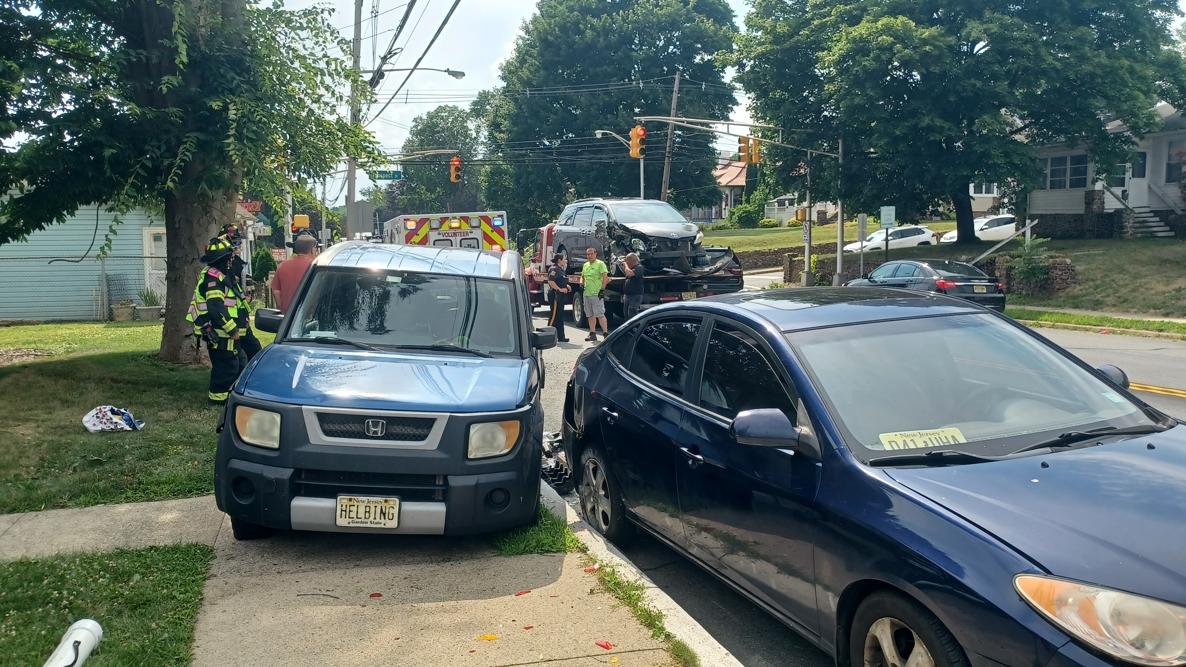
My car was pushed sideways an entire car lengthy up onto the sidewalk. All of the paneling inside it was pulled apart. All of the pretty new tires had exploded. I knew right away that the vehicle was totaled.
I tried not to freak out too much. I took all of the photos I could, grabbed as much stuff I thought I might need out of the vehicle, and let them hook it up and take it away.
I would have to wait three days at least to get a copy of the accident report. I was afraid right when it happened that the woman that crashed into me was uninsured because no one was speaking English.

My suspicions were true. There was an insurance card, but when I called Progressive insurance with the name of the woman on the car, they said this person is not insured with them.
The girl I talked to on the phone about it was nearly in tears, and told me she had just dealt with the same issue for her mother, because an uninsured motorist just crashed into her parked car.
I would have to go through my own insurance, and thankfully I had uninsured motorist insurance.

When I got on the phone with my own insurance agent, he told me that he had just dealt with the same issue, where someone with no insurance hit his parked car last year!
This was really an experience of the times. Politically, we're in a messy situation involving immigration, and police have told me that sometimes twenty different people could be using the same legal driver's license.
The collision was not just my car. A girl who works at the apartments named Angel had her car wrecked in the same crash, and she had no uninsured motorist insurance. She and I began corresponding, and she told me the girl that hit us had a facebook profile under a totally different name than the driver's license she turned in.

My own attorney and friend Conrad told me that trying to go after this would be like trying to get blood from a stone, so I just gave up on pursuing compensation from the other party for now.

I just had to figure out what I was going to do.
I had no ride to work the next day, and so I took the day off to try to figure out what to do.
I was supposed to get a rental car through my insurance, which deals with Enterprise. My insurance set it up, and they told me a car should be ready for me by the end of the next day, and that they would be delivering it to me at my job at Spruce Run.
This was too good to be true I thought, and it was. They never showed up at Spruce Run. They never even called. I called them back, and they said the car was not ready, but that it should be the next day.

The car was not ready the next day. Or the next. It tried calling a couple more Enterprise locations after reaching back out to my insurance to get a code I could use on these other locations, and no one had anything ready. They told me they were all affiliated, and if any of them had a car for me, they would be reaching out to me.
I called them back a few times, and I never got a car. They NEVER even called me back at all.
I can't believe that over a period of a week, no one ever reached out to me about a car at all.

I want to know what I'm paying for this insurance for if they can't even help me to get a car.
It turns out, they make very little money off of these insurance claims rentals. If Joe Schmoe comes in off the street and wants a rental, they'll go with him rather than me because they make more than they would off of some insurance contract that they're supposed to be obligated to.
This entire time, I had literally no help. Ev's mother has a car, but I was not allowed to use it.

To get to work, I had to bum rides. To get to stores, I had to walk. It was awful. I didn't even have my stroller out of the car yet to get Ev around, so I had a weird push wagon I was using.
I had to fight with insurance over the value of the car as well. I was going to get a couple hundred, then a thousand.
When they came up with a number of about three grand for the element, I had to show several other similar milage and year models for between 6 and 12 grand, and thankfully they came back to me with a number that was more than I paid for it!

The cost of vehicles has gone way up as well, by thousands of dollars, so it has gotten really tough.
I looked at a couple of vehicles around, but nothing was going to be easy for me to pick up quickly.
Thankfully, my brother Tea Biscuit came through for me at about the last minute. I was able to get a ride from my coworker Matt to his house after work, and picked up his car to borrow for a week or so while I tried to figure things out.
This got me the transportation I needed at least to get to the hike on Sunday, and to work for a bit.

I was still pretty worried about what I was going to do, but things were moving along.

When I went to get stuff from my car at the auto shop, it was not there. I didn't know what to do. I called after hours and got word that I could go to a secondary lot they owned to get my stuff out.
I went and picked up the stroller, tested it out a little bit, and everything seemed okay at first. I figured I'd get through the day okay.
The stroller was in fact NOT okay, and I wouldn't find out until after several miles into the hike.

Granted, I had already put about 2,500 miles on this stroller since I first got it as a gift from Annika Krsystyna, so it far outlived what it should have, but clearly the impact messed it up some more.
The front wheel area of the main frame had a crack, and it wasn't holding on by a whole lot. This was already bent a little bit from the past couple of years of use, to the degree that it had rubbed a hole into the undercarriage storage area.
I was too optimistic and just glad to be mobile again, so I didn't think it through all that much.

I got my stuff all together, and like on a normal Sunday, Ev and I were off to the spot I had set as the meeting point.
This time, it would be in the town of Oakland. I chose the Coppertree Mall on Ramapo Valley Road as the meeting point, from which we would shuttle north.
Thankfully, a couple of weeks prior, Jim Kohan had given me a new car seat, the next stage up for Ev. The old one would be considered totaled as part of the car, and so I would have needed a new one.

I was able to put this one into Tea Biscuit's car very easily, and I'd hold onto it for the next one.
The only sad thing with this was that I had been using the old car seat to get Ev around in my car, and the new one to stick in other people's cars for the shuttles.
We took my brothers car and one or two others to the starting point after we got stuff we needed from Dollar General and such. The start was at the Boro Field at the intersection of Sloatsburg Road and Margaret King Avenue.

There were people already there using the park when we arrived, playing sports, but we had plenty of room for parking.
Once everyone was together, we began our walk through the north side of the parking lot at the ball fields, and then to the right behind the dugouts and such, through the grass, and then out to Sloatsburg Road.
We turned right on Sloatsburg Road for a bit, which had no good shoulder, but we would be off of it soon enough.

We made a right turn onto Morris Road, which I figured would not be terribly busy. That ended up being incorrect, because there were a lot of park visitors traveling it.
I did my best to stay to the side pushing Ev in the stroller. We passed by several buildings, and then a convent property with a scenic pond on it on the left.
We passed by this property in the open areas, and it was really hot out, then entered the woods and with it the first segment of Ringwood State Park.

It was cool being up here, because my first official day on the clock with NJ State Park Service was in Ringwood.
Once in the woods, there was an abandoned bit of road on the left that left the edge of Morris Road into the woods. This abandoned road intersected with Cooper Union Trail, which I'd hiked several years ago.
We turned onto that a bit to the north, which wasn't really bad with the stroller. I had intended to stay on the road for a bit more to be easier, but this early on, I figured a bit of trail and more difficult stuff might be alright.

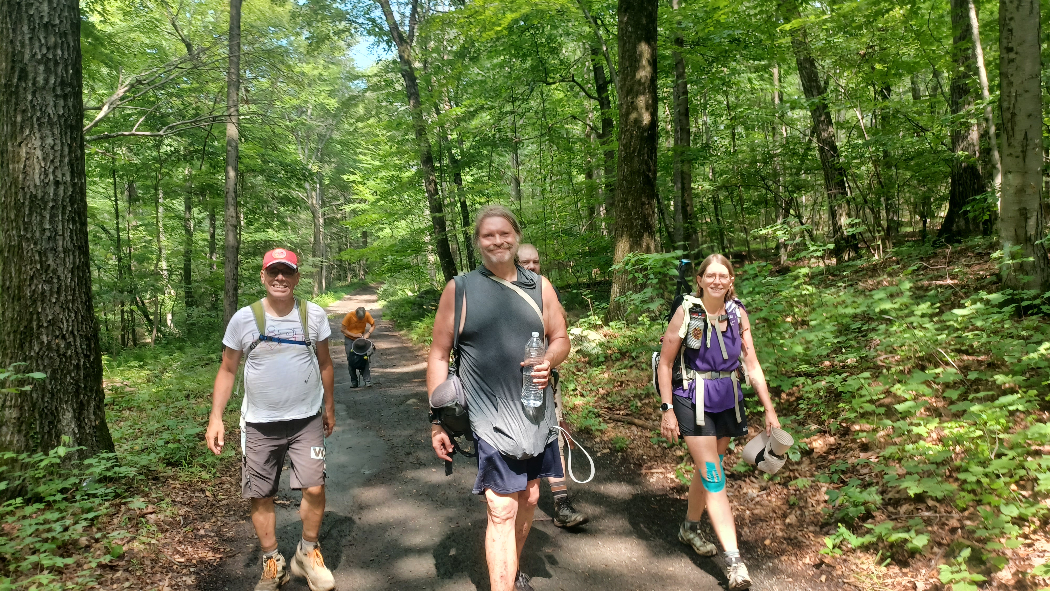
Ev got out of the stroller to walk for a bit here, and was immediately doing great. It was ridiculously hot and humid, but it didn't seem to bother him at all. Damien took his hand and helped him out at first.
We made a right turn ahead onto Cupsaw Brook Trail, which would take us to the east. The first bit we were on was a bit easier, but this one got to be a bit more rough. Still, I was able to more easily push the stroller along this because I didn't have forty pounds of extra weight. Ev continued walking on this, and was still happy to do so.

By the end of this day, it was some of the most Ev had ever walked on a single hike.

The trail got a bit rockier, and harder to push through, but I managed. The many little bridges along the way were the types of things that Ev really loves.
Ringwood-Ramapo Trail and Cupsaw Brook Trail were co-aligned for some of this distance, and we continued on them to the east. We would emerge at the Ringwood State Park toll entrance at Shepherd Lake as I was planning.
Just before reaching that spot, the trail joined an abandoned roadway. This almost looks like it would have been another road for one way in, one way out of the park.

Just before reaching that point, Ev started protesting the walking, and only Kirk was back with him. I had to hold off for a bit, and we got him moving again.
At this road, I think it was Justin that mentioned something about an old army tank being on the road if we only did a short side trip.
Of course, this sounded far too interesting not to go and have a look, and so several in the group joined Ev and I heading to look for this tank.

When we came upon what they were talking about, it certainly looked like it once had the shape of a tank, but I couldn't have been sure.

Many people have said that it was not a tank at all, but rather an old asphalt machine. Still, it had an alligator thing painted on it, and it did look like the shape of one of these tanks.
Later, I looked into this, and I finally got my answers starting with some hints from my old friend Brad Anesi who lives up just over the NY line from Ringwood.
This was an abandoned former military LVT (Landing Vehicle-Tracked) armored personnel vehicle that had been discarded alongside the abandoned park road.

Prior to being a state park, this area near Shepherd Lake was a skiing area, also reportedly known as Eagle Mountain at some point.

The former aquatic military surplus vehicle was acquired for reuse as a snow groomer, during the post World War II time period.
The State of New Jersey took over the property in 1964, and ski operations continued until 1973. The vehicle was abandoned in the woods west of Shepherd Lake at some point where it remains today.
Obviously, at some point someone decided they wanted to start cutting it apart and scrapping it, but then stopped for some reason. About a third of the thing must be completely missing now.

We made our way back up from the machine to the grassy area near the park toll.
Parks had been free completely because of an order by Governor Phil Murphy until the Fourth of July Weekend of this year, whe tolls started back up again.
I was hoping the concession would be open, and maybe even the beach at Ringwood, but the entire thing was closed off.
I found out from Greg Andre, who works up there now, that the plan is to close Shepherd Lake to swimming permanently.
It hasn't been closed all that long, but walking out toward the beach, it has completely grown in with weeds.
There was no concession, the only thing that was still operating along the shore of the lake was the boat rental, which looks to still be doing a good business. The entire area of beach complex buildings is apparently to be demolished in the very near future.

The only reason I have heard to keep the lake closed to swimming is because they cannot keep lifeguards staffed. It's rather shocking that this would be the sole excuse for not trying to open it.
It is a 74 acre spring-fed lake, and really one of the nicest of all of the northern region's six swimming areas, which also included Lake Hopatcong, Swartswood Lake, Stony Lake in Stokes, Lake Marcia in High Point, and Wawayanda Lake. At the time we did this hike, only two of those swimming areas were open for swimming at all!

This was the first commission by Architect John Russell Pope in 1895.
The chapel was a memorial to Dr Alfred Lee Loomis, who had been J P Morgan's Physician. Apparently, the handsome church within the park is still in service today.
Disappointed that there was nowhere to take a dip this time, we continued ahead, past the boat rental, and onto the old road along the south side of the lake, also route of Ringwood-Ramapo Trail.

We passed through a couple of stone stanchions, and continued through the woods with occasional good views of the lake on our left.
Soon, Ringwood-Ramapo Trail turned off to the right and we continued straight on the old road, now Shepherd Lake Trail.
Damien was having a hard time at this point, but Linda stayed back with him to egg him on.
We continued down a slope a bit to the east of Shepherd Lake, and the road wasn't really hard to push the stroller along.

was surprised to see no one down there. We were not very far at all from the lake where there were tons of people, but no one was walking this short distance away.
It was even more surprising when you consider that the route we were taking goes to an excellent backwoods lake.
The official trail went to the right ahead, and we turned on a road to the left that was not part of the official trail system, which leads to the Old Sterlington Road. I had hiked some of this on the NJ Perimeter series we did up in this area a few years before.

When we reached Old Sterlington Road, we turned to the right. At this point we were just over the New York state line.
We continued north on the old Sterlington Road, and eventually came to a hard angled turn to the right onto another road. Here, we were very close to the large Potake Pond.
I had had a good time swimming in this lake a few times in the past, right on the NY NJ state line. I ended up swimming across it on the state boundary or close to it.

The road we were following was shown on some maps as Skylands Road, and it does line up with the Skylands Road farther south on the NJ side in some ways.
My plan was to find a good spot with rock outcroppings and go for a swim. It was brutally hot out, one of the worst days of the year yet, and I needed to get in badly.
I found a good side path, parked the stroller, and we all went down to cool off. Linda finally caught up with Damien, and then there was some drama about him leaving his water bottle behind, but they found it.

We took a dip in the lake, which was really lower than it had been on my past visits, and much warmer than I'd experienced it before. I brought Ev in as well, because I figured he needed to cool off pretty badly.
We eventually all got out, and were on our way along the shore heading to the south again. We had crossed back into New Jersey, and then came to an intersection that actually had a trail marker, so it clearly was not somewhere we were not allowed to be, although signs in other areas would make one assume this.

We turned left here on another old woods road that is known as The Cape Road. This roa heads to the north a bit, then east and then south where it was showing as Blueberry Way, and heads toward a formation of land known as the North Cape.
I'm not sure what all of these different roads were called historically, but today the park maps call this simply "mountain bike trail".
We continued along this as it took us to the south. It was a bit bumpy at times, and definitely rough on the stroller. I could tell I was starting to have more problems with the wheels bending back.

We followed the woods road/mountain bike trail to the south until we got to the buried Tennessee Gas pipeline.
I had been involved in some of the state stuff with this when I was first hired. I authored the Resources Impacted and Mitigation Report for the state under Steve Ellis with proposals for restoration of historic structures and repairing trails for the damage being done.
I was pretty much the reason they didn't end up closing as many trails because I was able to quite the National Trails System act regarding trails connecting to the Appalachian Trail or other federally recognized trails.

My original plan for this hike was to turn to the left and follow the gas pipeline, which had a reasonable road along it, to the east until we got to old Mountain Road, and then follow that to the south.

I figured it would be an easy push, and if the stroller was in good shape, it would have been.
The problem was, the front wheel of the stroller was bending forward and I couldn't push it well. Whenever I had a good degree of momentum, the front wheel would turn, and then bend under sideways. I couldn't operate the thing to save my life.
Every time I did this, it would jolt me. It's bad enough recent X rays showed that the lower bones in my back were bone to bone with nothing in between. This was a horrible push on it, and I was getting more and more sore as time went by. Pushing on these slopes was going to be incredibly rough.

I checked over the maps to see if there was any way that might be a little easier or quicker with the stroller, and everything else looked like it would be farther and potentially more difficult. The only benefit of going any other way was that it might give me some more shade. I couldn't take that gamble.
We had to walk the gas line, and it was going to be rough. It was uphill to the left.
I started pushing, and it was rough going over the rocks. The front wheel kept on doubling over, and I had to be carefuly how I was pushing not to break it off completely.

If I could at least get to Mountain Road, it might get a bit easier.
Linda was falling behind with Damien, and Cory told them to turn back and head back to the cars in Ringwood, because they didn't have enough water and Damien wasn't going to make it. We didn't see them again at this point.
We continued uphill, then down a bit which was easier. The woods road on the gas line turned to the left near the bottom to avoid a swamp. This woods road went way into the woods to the north of the gas line to avoid this swamp, but it had some big puddles in it. It made for some rough walking once again. Ev got out of the stroller for a lot of this and walked with Jenny.
 |
| Historic view of the ski slopes that used to be in Ringwood. |
He handled all of this pretty well, but occasionally insisted on being carried, which made it a bit tougher.
We weaved around the wetlands on some really rough road, and then returned again to the gas pipeline and turned left.
Again, we went uphill on another slope that was rough on the stroller, and then down the other side. Ev walked much of this himself, and then into the woods again to the left where the pipeline went through another wetland.
We crossed the Bear Swamp Brook on a causeway, then turned to the right over a rocky woods road heading to the east, then southeast to eventually re-join the pipeline.

I was breathing heavily and really struggling to get the stroller through all of this. Kirk was helping me a lot through this, and it was wearing pretty badly on him as well.
Jenny tried carrying Ev for some of this time while he was being too fussy to walk, but he's getting too heavy to carry these days.
The stroller just kept failing with the front wheel, and rather than use the pivoting function, I had to turn it the other way so just the straight function was in use. That was not helping much though, because it kept coming out of place and bending back over.

We had one more uphill to do on the gas pipeline before we reached Mountain Road, and I tried as carefully as I could to push the stroller up the slope to this point.
We reached the top and the old Mountain Road, which joined the gas pipeline to reach the Mahwah Meter Station just to the southeast of this point on Monroe Ridge.
We still had a very long way to go, but being here was a huge relief, especially when seeing that the road looked much improved. Usually, the surface of this road would have been an incredibly easy walk with the stroller, but with it damaged, everything was tough.

We started walking Mountain Road to the south, which was paved at times, other times gravel, and didn't have a whole lot of potholes. It was just pleasant, and for the first time in what seemed like an eternity, I could relax a little bit.
The old road was joined by Shore Trail as we came near the Bear Swamp Lake to our right.
A side trail called the Rocky Mountain Connector I think went to the left, as well as another woods road to a power line clearing.
To the right, we soon came to some old foundation ruins. I went over to have a closer look at them, and assumed that it must have been some sort of old scout camp, but it was actually residential.
This was a small community of a dozen or so homes in Ramapo Mountains, mostly summer homes at one time, developed in the 1930s and 40s. Most of them were destroyed when the park took the land over in the early 1980s. This section is actually considered part of Ringwood State Park rather than Ramapo State Forest, although they cojoin and are administered under the same park staff.

There were steps, foundations, chimney remnants, and some metal all along this stretch.
When we got to the lower end of the lake, there was a footbridge over the spillway where Shore Trail crosses. We checked out the splendid view of the lake, and then continued ahead on Mountain Road.
There were no signs saying that we couldn't walk this road, so I was happy to just continue on. It looked like we could escape the forest by just following somewhat easy roads like this.

We descended a bit more steeply, and the stroller just kept getting worse. Ev got in it again a little while back, and was taking a nap, but it wasn't a good one. The stroller kept having the wheel in the front roll over and come to a sudden halt, which would wake him up.
I could see that it was bending back way too much, and that a piece was coming off. Ev had been drinking chocolate milk earlier in the day, which is common for both of us, and I still had the empty bottle in the pack. I used it to try to create a sort of buffer to kep the wheel from falling backwards. I got my pocket knife out and helped to fit it over some of the framework to act as a sort of bumper against the main frame of the stroller. I felt like it improved the situation a little bit for a while, but it soon started busting over again.

The road steeply descended and crossed over the power line clearing twice. Near the bottom, Ev was awake, and I saw the Bear Swamp Brook was coming closer to the road. I walked him over with me and I went in to lay down right in the brook. It felt great and was much needed after all of the hard pushing.
A little bit beyond this point, we reached the road that goes to Camp Yaw Paw of the Northern New Jersey Council of the Boy Scouts. The road is labeled both as Bear Swamp Road and Cannonball Road.

The Cannonball Road was a secret road through the Ramapos used during the American Revolution that was kept sort of secret even after just incase it was needed again to move munitions. I always thought the road continued up to Ringwood and the iron furnaces there, but the trail seems to end up in this area, so I don't recall exactly where the official road was supposed to go.
I recall a car going by, maybe it was twice, but other than that no one came through on the road the entire time we were on it. It was a very pleasant walk, and much better paved than Mountain Road was.

Despite all of this, the stroller was failing me even more. The wheel was curving back and bending under almost completely. I kept trying to move it forward, but the chocolate milk container was no longer doing the job.
I tried to hold it together, and even though walking gradually downhill was much easier, I had to keep bracing myself for the stroller tipping forward.
The road came to a point where it crossed over Bear Swamp Brook, and the Yellow-Silver Trail of Ramapo Valley County Reservation crossed over on the same bridge. There was some sort of stone ruin with no roof off to the left, which was probably once associated with the scouts. We continued on the road downhill.

There were several utility poles all along the road, but they were collapsed and laying down often. There was no electric to any of the wires, and occasionally they were completely severed.
I went over to the edge and found several pieces of wires and pulled them off for use on the stroller. I left the chocolate milk bottle for a bumper in place, but then wired a couple of wires together from the end of the frame to the front of the stroller forks in order to hold the thing in place, and thankfully it worked. In addition, Jenny gave me a shammy material thing that I was also able to help tie this stuff off with so that it wouldn't move any farther forward. I wired it all back into the front frame of the stroller and tightened it up by twisting it. This was one of the most MacGuyver things I've ever done out in the middle of nowhere.

It was much more pleasant walking for a little while. We continued downhill on the road, beside the brook, and private homes started to appear to the right. Cory was trying to get hold of Linda and Damien, and it turns out they did not turn back to Ringwood. They tried to continue following us, and were somewhere up near Bear Swamp Lake. Cory and Dan tried to get an uber out of there when we got down to the bottom of the hill at a very nice little bridge that crosses into the Deerhaven Community, a private road. I got a group shot with us all sitting here, and Jenny, Justin, Robin, Diane, John, Kirk, and I all continued on.

At the bottom of this hill, there were signs reading that public was not allowed on the road we had just walked down, but thankfully we hadn't had any problems with it. While we were sitting on the bridge at the entrance to the private Deerhaven community, a guy pulled over and asked if we were alright and needed help.
We continued down the road ahead, and soon approached an odd bridge over the Ramapo River. This was the historic Cleveland Bridge, which at first looked like nothing special at all.

At first glance, this looks like a simple military Bailey Bridge of no particular consequence, but looking more closely, one will see outside of it the rare historic 1888 lenticular truss bridge by the Berlin Iron Bridge Company of East Berlin CT.
Lenticular trusses are sometimes referred to as "pumpkinseed bridges" because of their profile.
This is one of only two Ramapo River bridges to survive the flood of 1903. It is named for President Grover Cleveland of NJ. It replaced an earlier 1840 wooden structure that served the logging interests in the Ramapo Mountains.

The bridge was repaired in 1923, and again in 1983, but more work was needed in recent years.
Rather than rip the old bridge out, the Bailey Bridge was placed over top of it, so the original bears no weight. There is only a small community, as well as Camp Yawpaw that uses it for access, so it appears to have been enough.
It wasn't until I got to the other side of the bridge and looked at it from the downstream side that I could see the significance of the structure. The only other lenticular truss in NJ would be the one in Neshanic Station NJ, which I had also done many hikes across.

It's hard to pick out what part of this hike was the worst part, especially since we were on better terrain, but we had to turn right on Rt 202 which was particularly horrible with no shoulder. I had hoped that we'd be able to get off of the road to the left onto a parallel side road, which on Google street view had no signs saying to keep out, but now had them in present day. This was the old entrance to the Carmel Retreat in Ramapo Valley NJ.
Built in 1906, the property, which contains a Dutch colonial house, carriage house, and other structures, was home to a group of Catholic friars until closure in 2012. After 2019, it was taken over by Hackensack Meridian Health and now serves as a love outpatient drug rehabilitation site known as Retreat & Recovery at Ramapo Valley.

We had to just stay on the highway for this entire stretch, which had next to no shoulder, and fortunately the group stayed close in front of me to alert people driving that there were people there, because I wouldn't have wanted to be up front with the stroller.
Along the road on the right side was an historic home knwon as Amberfields, a 1781 Dutch Colonial structure. Severeral historic components and out buildings remain at this early Bergen County homestead. Google maps also shows the Amberfields Cemetery is adjacent to the house, which I had considered visiting, but there was no way I was adding anything extra on at this point.

On the left side of the road, there were some masonry foundation ruins, but I have no clue what they were.
We continued on 202 until we reached Glen Gray Road and turned right. It was a major relief to get off of that busy road. At this point, Justin continued to walk straight on the highway rather than make the turn. I didn't want to have a mishap on the road, so I wasn't going to take a chance. The stroller was still failing, and the front wheel was still occasionally shifting to the side and doubling over, requiring constant maintenance of my MacGuyver job.

There was a trail to the right side of this road I had been unaware of in the past. That was the first shock. Then, I had looked up this bridge ahead, and it was close to traffic. I just figured we'd be able to cross it anyway and took the chance. The road to the right goes up the ridge to Camp Glen Gray, but my plan was to cross and cut to the left through a development, some of which has a trail directly along the river.
As soon as I crossed the bridge, I parked Ev on the shore briefly and ran down to lay in the river for a moment. I was sweating horribly after pushing the stroller so hard for so long, and there had been no good way down when we got to the Cleveland Bridge.

There was a path to the left, but it had no trespassing signs, so we continued left on Hunters Run. We went uphill for a bit, and John got way ahead of Jenny, Robin, Diane, and I. I think Kirk also went with the others a bit earlier or kept going with Justin.
Pretty soon, there was a set of stairs that went down between townhouses, to a trail along the Ramapo River. Diane helped me down the steps, and we continued walking on a lovely trail directly along the river.
The trail turned back up to the streets and emerged on River Dell just ahead, and we turned left. We turned left on Overlook Ridge to Patriots Way, where there was a bridge closed to traffic. We thought to maybe cross it, but it was too well blocked off. We had a closer look either way.
There was a trail that continued on along the waterfront below Patriot's Way. We could have gotten down to it, but I barely had it in me to push any further. Plus, I wasn't sure if it would go through. The other option was to walk uphill on Ramapo River Terrace, then down by Crystal Lake toward the strip mall. That would be another 2.4 miles, and it was looking like based on my mileage, we had already done about 15 at this point. I was happy with that.

I got a hold of Dan to see if he had left yet, and thankfully he was still around. We were able to get picked up by the group there, to finish our brutal hike.
I was able to get a ride back to Tea Biscuit's car and get back home with no problem, thankfully. Once the hike was over, the stress of everything else just piled back on again.
It had been a really interesting day, and pretty fun for much of it, but I was extremely tired.
Over the next couple of days, I never heard from Enterprise Rent A Car. I was so fortunate that my brother allowed me to keep using his car, because I'd have been completely screwed otherwise.
I would push Ev around town in a toy car a lot over the next few days, and spend lots of time on the phone or traveling back and forth to my Honda Element just trying to get the remainder of my stuff out of it so it could be towed away without charging me storage for the thing.

Ev was turning three this week, and I tried not to be negative in the face of all of the adversity, but it was a struggle to try to hold it together.
No comments:
Post a Comment