

Hike #1609: 6/16/24 Pennypack Creek with Jenny Tull, Dan Lurie, Diane Reider, Kirk Rohn, Professor John DiFiore, Carolyn Gockel Gordon, Robin Dietz, Serious Sean Dougherty, Heshy Busholz, and Heshy's daughter and friend

This next hike would be a point to point on the Pennypack Creek, in a section that looked like it would be a perfect Summer hike for constant dips in the creek.
It worked out perfectly, because it was a really hot day, but we did take it a bit far this time!
I had done a variation of this hike before, but there was a lot more in the area I wanted to do. The first time I hiked through this section was part of a trip that connected us over the Tacony-Palmyra Bridge to the NJ side.

I had planned out the trip another time just before Ev started coming out with me every week, and it was supposed to go all the way down to the Delaware River and connect to the trail system there.

That hike ended up going over the length I was planning, and we never made it to the Delaware.
There are several different trails along the Pennypack, and we'd taken shortcuts even on that last one. I wanted to try to do much of the main trail and not miss anything, but also do the trails that connected from the Delaware River.
As such, I decided that the hike would start down along the Delaware River and cover these connecting trails first, near the beginning of the day so we wouldn't be so hot and miss swim spots, and then by a time before noon, we would be on the main Pennypack Creek in a more secluded area so we could enjoy it.

With that, I had to plan on a location to start that would be closer to the 15 mile mark rather than head up further.

I chose the Pennypack Trail parking on Old Huntingdon Pike, just below Betheyres PA. As a backup to that, I chose the hospital property on the north side of Huntingdon Pike as the point we'd use for backup parking in case there were no spots.
We all got down to the Old Huntingdon Pike lot, but there was indeed not really enough parking. I think we left one car there or so, and then shuttled the others up to a lot that wasn't posted at the Holy Redeemer Hospital area. We then shuttled in other cars down to our starting point.

I chose North Delaware Avenue as our starting point, in I believe the Torresdale section of Philadelphia.

We were running a bit behind, and then I had to get the stroller together and all. It was a brutally hot day, and I couldn't wait even at the start to get to where we could swim.
There was a sort of little green park along the Delaware River where we were parked, through the grass, and there were remnants of some sort of old pier at that point as well. I'm not sure what it was.
In the weeds at the end of the old pier was a small cat colony we checked out, but none of them were friendly enough to pet them.

When we were all together, we headed to the west just a bit and entered park land at the Linden Avenue Boat Ramp. A concrete walkway went out and around some trees to gain the waterfront.

On the first corner, there were some mulberry trees, which Ev had to stop and pick.
We got out to the waterfront and continued out to the boat ramp, and then headed north into Pleasant Hill Park.
Heshy was calling me at this point, because he lives in the area and was planning on just joining from the start, but he ended up walking the wrong direction to find us from the start.
Heading inland, we passed a brick building with a mural of fishermen on it. The historic fish hatchery area was just north of this point, and a walkway went up through the center of it heading north.

The Torresdale Hatchery began operation in 1904, to replace an older one at Bristol in Bucks County.

The hatchery was taken over by the Philadelphia Department of Recreation in 1956, and began hosting youth fishing, and it has evolved into the park we have there today.
Beyond here, we moved out toward Linden Avenue and started heading north on paved trail. This is labeled as Baxter Trail, which is part of the Delaware River Greenway.
The trail continued northwest along Linden Avenue, and then turned ninety degrees to the left to parallel State Road beside the Samuel S. Baxter Water Treatment Plant.

Just ahead of this point, the paved trail was closed up along State Road, and a temporary walkway was made out into the edge of the traffic lane ahead. It seems that there is some new development going into what had been brownfields here in the past.

We continued along this beside State Street for a bit, until we got to Pennypack Street, where the Baxter Trail turned hard left again to head back out toward the Delaware, alongside the road.

A little ways down, the trail turned ninety degrees right again, away from the road and skirting fences on either side.
Ev noticed a fire truck parked down below us to the left before I did. This property we were skirting was the home of the Philadelphia Fire Academy.
The trail turned left, and skirted the outside of this, and we passed by a very good sized five story building, which is used to create mock emergencies for training scenarios here. It was quite impressive to see, and there was actually a training going on while we went by.

On our right, we started skirting a very high wall, which looked extremely odd. We turned to the right in close proximity to this thing.

The entire wall was constructed of wooden planks, some of which were popping loose because of the strange, curved angles of these walls.
Heshy called me up again to figure out where we were, and he had gone as far as the Pennypack on the Delaware Park, and would wait for us there.
Heshy explained to me that these walls were a barricade for protection along the only major shooting range within the borders of a major US City, in America.


The wall ended, and we came to a large prefabricated pedestrian bridge over the Pennypack Creek, the first view of what we'd be following for the remainder of the day. It hit the Delaware River just to the left of us as we crossed.
We went over, with good views, and then turned slightly left. There was another trail that was not paved, which broke off to the left, but we didn't follow it this time. I figured it's just an excuse to come back and do more in the future.

The park lands we were passing through was a wetlands restoration project to replace wetlands that were destroyed during airport expansion downstream.

The trail weaved around a few corners, the side trail on the right returned, and another side trail went to the right. We continued to the left, out along the Delaware.
There were some good views along the river at this point, and it was loaded with sail boats.
The boats surrounded the historic Riverton Yacht Club in New Jersey, built in 1881. It is the oldest operating yacht club on the Delaware River.

It was a pleasant and scenic walk along the Delaware River heading generally southwest, and there were a whole lot more people in this park, known as Pennypack on Delaware.

We continued out to a corner where there was a little pavilion out on the water. People were already occupying it, so we didn't go to bother them.
We met up with Heshy's gang in this area to continue on.
There was a long pier out onto the water to the left just ahead, and I thought to go out on it, but it was just getting too hot and I didn't feel like it.
We continued on the trail, which was soon parallel with a road known as Pennypack Path. We continued to the north on this, and were son parallel with the jail, the Corran-Fromhold Correctional Facility.

The trail continued along the road ahead, and beneath Interstate 95/Delaware Expressway.

The trail route turned right onto State Road, crossed to the north side. It then passed under 95 yet again, and an independent paved pathway from the road started at about the point under the bridge. Pretty soon after we were beneath, the trail turned off to the left and descended somewhat toward the creek, which had not been accessible, because it had gone through the prison property.
After reaching the edge of the creek, we immediately passed beneath 95 for the third time, which provided us with some brief shade.

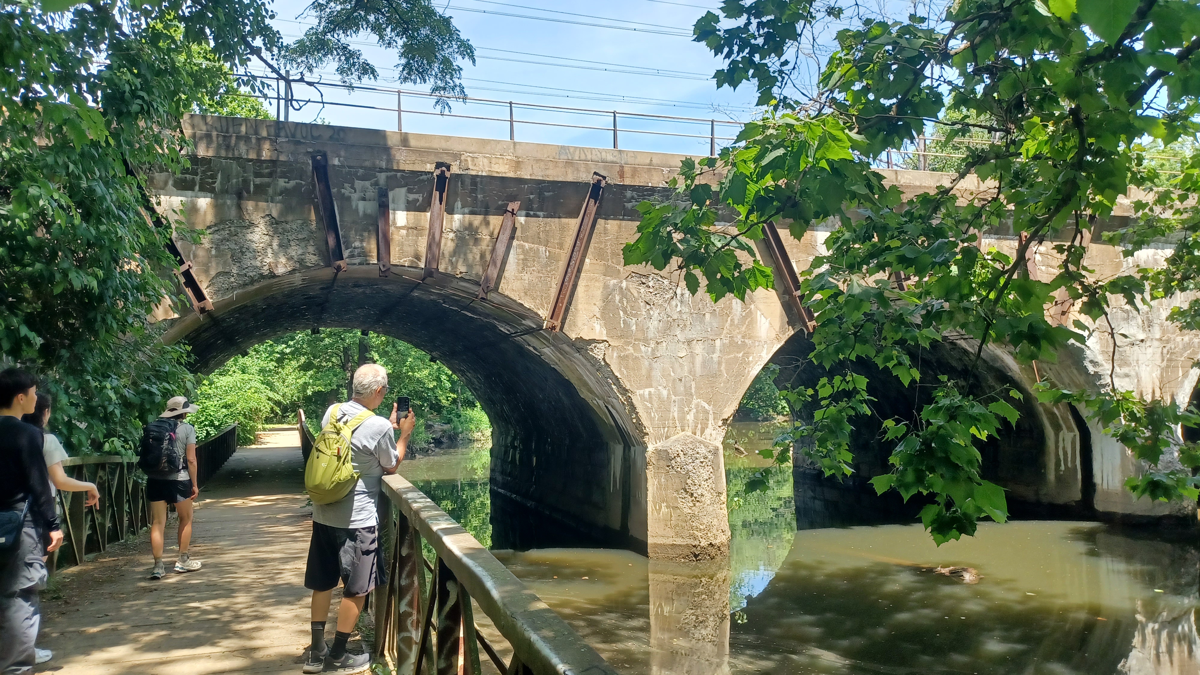
The trail continued along the west side of the creek upstream for a bit, and soon we passed beneath the historic Pennsylvania Railroad bridge.

This would be the four track original main line heading north toward Trenton. The arch span looks concrete approaching it from the south, but the majority of it is still handsome cut stone, and the facade still looks great on the upstream side.
I tried finding information on this historic bridge, but unfortunately it is mostly all obscured by the many historic bridges that cross the creek in this close proximity.
Another very nice prefabricated foot bridge carried the trail along the west side and under one of the arches of the bridge to continue north.

We continued to the north for a bit, and followed the right fork to keep along the edge of the creek. We then emerged on Torresdale Avenue. The trail turned right here.

We crossed the Pennypack with a nice view downstream, and then approached the historic Holmesburg Prison on the right side. The turreted northwest wall was in view.

The prison operated from 1896 till 1995. It is occasionally used for overflow or special uses as I understand, but for the most part is no longer in use today.

This prison was the controversial location of dermatological, pharmaceutical, and file chemical research projects on inmates. At one time, 80 to 90% of inmates were experimented on. This and other landmark cases such as Tuskegee Alabama influenced the drafting of the Nuremberg Code, which sets principles for legal and ethical research on human subjects.
The trail turned left, crossed Torresdale Ave, and then descended past a baseball field into the woods along the east side of the creek.
We passed through woods and soon reached Frankford Avenue, at the oldest bridge in America.

This road approach would be our only store stop on the entire hike, and so we took a side trip up to the right here.
We walked up Frankford Avenue to the right, and there were police parked on the north side of the road, I guess patrolling for the park or something.
We walked up into a strip mall, and there was a small pizza place in there called Northeast Pizza Company, as well as a Dollar General.
As I recall, I needed something at the Dollar General and went in to get it, but also got an ice cream bar for Ev and myself. I think I also got a slice of pizza or something for us, I can't remember.

I think it was Diane came out with a bunch of ice cream to share with everyone too, but we were too stuffed to have any at that point!

Cold Case Beer was also at this location, so I went in to have a look around and see what they might have had. There was nothing I was particularly interested in, but I wanted something cold. So, I had a Four Loco Jungle Juice, which I don't think I'd ever had before. This was probably the beginning of the problem, because I don't have those often.
We made our way back over across Frankford Avenue, then downhill across a mowed park area. There was a side path to the left with a good view of the historic Frankford Avenue Bridge, also known as the Pennypack bridge and King's Highway Bridge.

Built in 1697 at the request of William Penn to connect his new home to the City of Philadelphia, Pennsylvania. It was widened for both trolleys and automobiles, but the original bridge remains, making it one of the oldest continuously used bridges in America.

The bridge was widened to accommodate more traffic about 1893.

There were some people below sitting along the river, probably unaware of just how historic this bridge is. I thought I got a good picture that might work with a then and now, but it seems all good historic shots are taking from the other side of the bridge, the downstream side!
The trail took us along the edge of the creek more closely, and past the site of a dam that once served the milling interests of the Frankford area.
A little further upstream from there, we approached and passed beneath the deck girder bridge carrying the former Bustleton Branch of the Pennsylvania Railroad.

There was a nice walkway beneath the tracks, and the trail continued along the creek beyond with some nice pools off to the left. I went and stood in one, but I wasn't ready to immerse myself just yet.

retty soon, we came to our first crossing of the Pennypack Creek on its own independent trail bridge.
I think there was a trail on the other side of the creek from the main trail at this point, and Heshy said that although it is rougher, I should be able to get the stroller through it. I decided to keep to the easier side this time, just because some of the recent hikes were rather rough and I wanted to continue the relaxing type of stuff we had done just the previous week for a while.

I chatted with Heshy about his political career, being one of the only Whig party members holding an elected position in America (I think the only other one was a school board guy in New Jersey).

He was saying that someone was being trained to be his successor, and that he was considering moving from Philadelphia in the near future. He said he was going to move earlier, but that his kids didn't want to give up Pennypack, because they lived so close.
It was a very pleasant walk weaving from north to west and we passed beneath the Welsh Road Bridge, also known as the Echo Bridge.
I sang something going under it, but I don't remember what it was. On the other side, we passed through an open area and the Ed Kelly Ampitheater.

We continued on from here, and the trail was quite pleasant. A side trail to the left led to the ruins of a sort of fireplace chimney. I'm not sure if this was part of a home, or a fireplace for the park.

We crossed another foot bridge over the Pennypack, then turned to the left along the edge of a parking area. One of the side trails that had been another option appeared to the right.
Carolyn was planning to meet up late, as well as Sean, and they were both trying to meet up separately. We started trying to get them together, because Carolyn was having trouble figuring out where to park, and Sean can figure those things out more easily.
We continued along the parking lot and took a break under the Rhawn Street Bridge to try to let Carolyn find us, because she was so close, but then she didn't make it.

There was a police officer parked directly beneath, so I'm not sure if we could even park there anyway.

We soon continued on along the trail, at this point to the south. The last time I was out in the area, we took a shortcut over this bend in the creek, and I wanted to be sure to stay right on it.
Before any of the others got in the water, I took a couple of opportunities to just jump in and rinse myself off of the sweat. It was a great idea each time. We were up the stream far enough that the creek looked quite clear.
This was in or around the Winchester Park section of Philadelphia, and the Rhawn Street Dam used to be in this area since about 1799.

It is amazing that so much industry once thrived on the Pennypack, but there is so little remaining to see of it today.

Ev got out of the stroller to walk from time to time, and Heshy's daughter even carried him for a bit. She's pretty strong to carry him being almost forty pounds now.
After weaving around a corner, we passed beneath Rhawn Street yet again. There was graffiti under that read the "cock block kids", and I quipped that we were cock blocked and pennypacked all in the same day.
We were heading north again, and soon passed beneath Holme Avenue on a lower clearance bridge.

A little bit to the north of this underpass, we came to an intersection where the trail turned hard left on what looked to be a former main road route. A small tributary flowed in from the right and a bridge crossed over it.

We continued on this more main road to the west a bit, and it continued pretty straight. We eventually came to the Roosevelt Blvd bridge, which was completed in 1920.

This is apparently also called the Bensalem Avenue Bridge.
This was a very high bridge, with a high clearance arch. We continued on from here upstream, and there were plenty of lovely spots to take a dip in the creek on the way.
There were old dams in the creek to the left of us as we passed through this area.
The trail came up next to Winchester Avenue in the next section ahead, and then dipped back down toward the creek a short distance beyond.

When we reached the next creek crossing, it was a smaller foot bridge, but this time with some ornamental metal on the edges of it. It likely dates back to some of the earliest days of Pennypack as a park.

This was in the Rhawnhurst section of Philly. We continued up the stream on the west side, and soon passed beneath Bustleton Avenue.

Another very pleasant section was ahead, as the stream shifted to the west a bit again. We then entered the Krewstown vicinity.
Soon, we reached the Krewstown Bridge, which looked like a concrete arch structure.
The bridge had me totally fooled. This is actually an historic bridge over the Pennypack dating back to 1800! It was given a new concrete facade in 1907, making it look like a much more modern bridge.

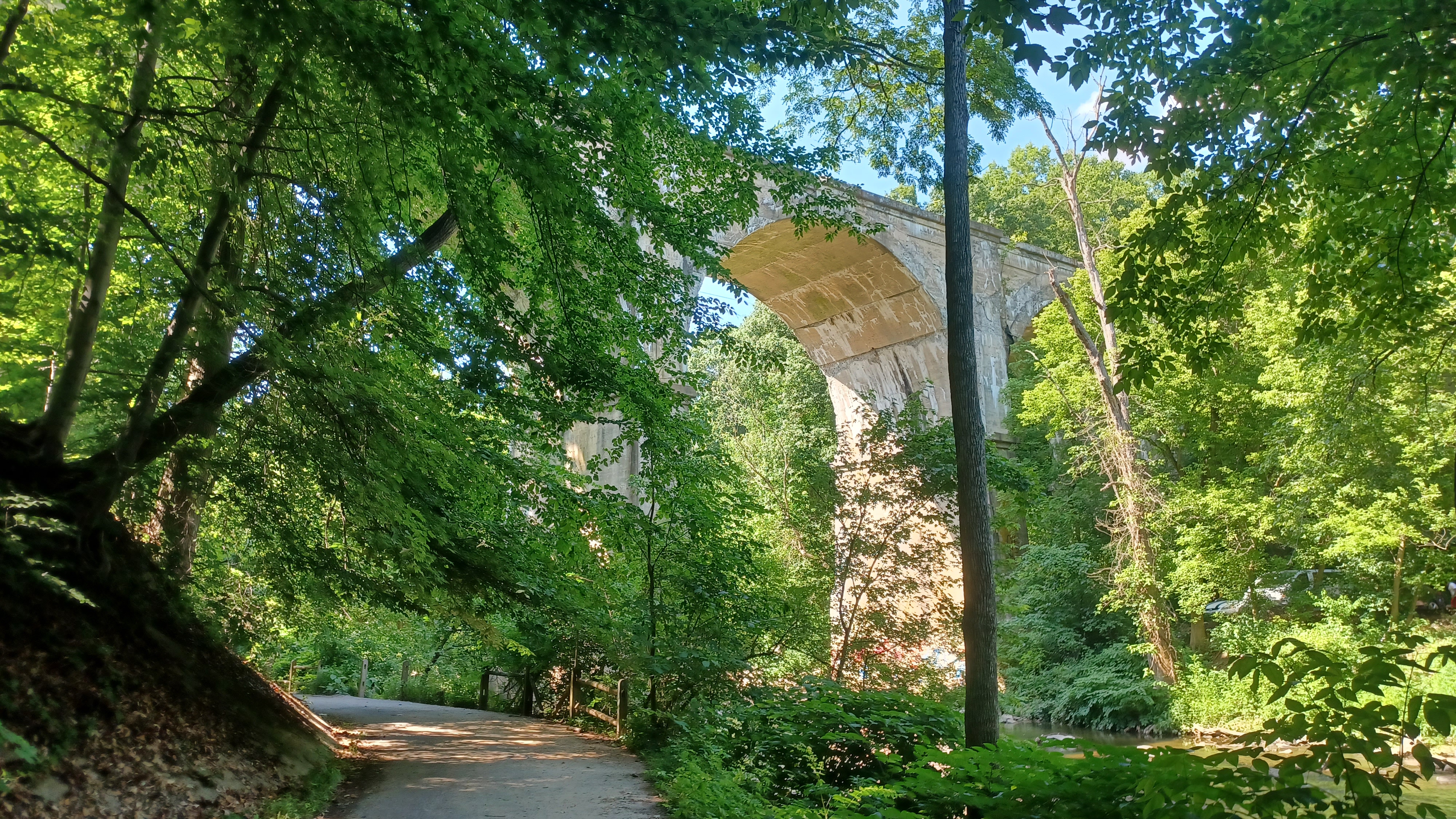
We soon approached the "90 Foot Bridge ", the Pennypack Viaduct of the former Philadelphia and Reading Railroad, built in 1906 for their New York Shortcut.

The enormous bridge was certainly a sight to see. My first time walking through, I just had to climb up top to get a view of it. It remains very active today.
Somewhere right in this area was where Carolyn and Sean showed up, and we all started getting very silly. I finished the loco thing I'd bought and was on to more regular stuff, and the Not Piss came out.
The trail weaved around for a bit again, heading west again, and we came to where there was a side trail that went up into the Fox Chase neighborhoods. Heshy and his crew left here to head home.

The rest of us went a little bit further ahead, and then found a good little rock outcrop and place to take a dip in the Pennypack for a bit. It was really hot, and it was a good stop.

It was a long and relaxing expanse, close to the creek, which weaved around a lot. The trail went up and down quite a bit, but we were having such a good time that it wasn't hard.
We eventually crossed Verree Road, and then continued to the north a bit more upstream, still on the west side of the creek.
There was another pleasant looking dam in the stream just above here, and the creek took a long curve to the northeast here. The trail took a much shorter route to the west to get back to the creek.
The first time I'd hiked this, it was a crazy situation where we tried to follow right on the creek, and walked through the middle of it. Sean was there and had his bicycle with him, which he was carrying on or over his mead much of the way.
The water got to be over our heads on that one, but it was really an incredibly fun time. It was a trip how quickly, just a matter of a couple of minutes, we passed by this section this time!
We continued west and upstream, and the creek moved off to the right a little bit before we reached the next parking area. In the past, I'd followed directly along the creek here, but this time remained on the trail since I'd never done that before.

After passing along the parking lot, we crossed Pine Road. This is the point where the greenway really changes its identity a lot.

The trail goes into an open meadow area and becomes a mowed path on the right sides of the fields.
It's a beautiful section on one of the most beautiful and few remaining upspoiled bits of farm land in Philadelphia.
We continued along the edges of the fields, and a side trail went to the left at one point.
There are a ton of other trails through this entire area that still need to be explored, so I hope to do a more full Pennypack series in the future.

We continued into woods and entered Lorimer Park. We kept to the right, close to the creek, and soon approached parking and Moredon Road.

We walked north along the creek through the active picnic area, and paused at the foot bridge across the creek to the right.
Across the creek was a good view of Indian Council Rock, which is an imposing tall crag with trails around the sides of it.
The perch high above the Pennypack Creek is said to have hosted meetings of aboriginal peoples.
We made our way further from here through the picnic grounds, which were very full of people, but the trail sort of ended at the end of it. I'd never gone this way before. I had only ever walked the railroad bed to the west, or come down from the Council Rock the ways I had gone.

Since there was no direct trail, we weaved from the north side back to the south, through the grass, and eventually there was an informal trail to the west, which climbed up to the rail trail.

This was the former Newtown Branch of the Reading Railroad, which had been the subject of my hikes many times over the past several years.
The line was first built through to Newtown in 1878 as the Philadelphia, Newtown, and New York, Railroad. The line was built to sort of block the “National Railway” which later became the main Reading Railroad line to New York City.
The line was funded by the Pennsylvania Railroad, but then became part of the Reading after the National Railroad was constructed despite the efforts to block it.

Service continued through to Newtown, even after Reading Railroad merged into Conrail in 1976 and railroad traffic was reaching a national low. The line had been electrified as far as the Fox Chase Station by 1966, and diesel shuttles continued through the early eighties.

SEPTA took over passenger services on the line, and shuttles continued through to Newtown until 1983.

The line was an important commuter connection between Newtown and Philadelphia, but SEPTA didn't want to run diesels anymore. Despite having replaced the ties and replaced spikes with expensive pandrol clips, the line was let go.
Now, it is part of the Pennypack Trail, with more sections under development.
The sad fact is, there was already a trail immediately parallel with the entire route from Mason's Mill Park south to where it becomes active at Fox Chase.


I must say, that although it seems the most foolish move in the world to let such an important passenger rail route go, the trail does get pretty heavily used. In many cases of rail trails, I see the trail barely get any use at all, but that's not at all the case here.

The first time I walked through, it was only on a piece that was the trail, from about Lorimer Park as far as some point to the north I don't exactly recall. Then it was extended to County Line. I walked the entire line about that time, and the stuff above County Line was just about to come out.

Last year, I hiked the bit below to Fox Chase from above Southampton as a through hike again, and that bit had not been done yet.

Now, I understand that it is all trail from Fox Chase north, although I have not seen it yet.
When more of it is entirely different, I might revisit the line again, or when I put something together for connective open spaces.
This time, we'd only be on the right of way for a little while for the home stretch of the hike.
We followed a pleasant section high above the Pennypack for a bit, and Kirk and I were drinking the Not Piss and having a good old time.


There is a side trail along the way that leads down to the Pennypack where it isn't terribly steep, and my plan was to head down to that for a final swim time.


When we came to that intersection, we turned right and went down to the creek. There were only people at the very first access, and we went slightly further to find no one there.


We all went and laid in the creek, and Ev had fun playing around and throwing rocks. We spent a little while there, to the point where Diane and Robin decided to go back because we were taking so long.

I hadn't been so out of it that I lost any memory, but I guess at this point I did. Ev was fine, and hanging with Jenny and the others while Kirk and I were apparently holding hands at some point, or otherwise leaning on one another.
We walked the remaining distance on the rail trail back to the lot on Old Huntingdon Pike, and we were apparently laying down spooning next to the park sign.
I have the pictures to show me that Sean also brought some of the delicious Lagunitas Waldos special IPA, which is just amazing stuff, so that also contributed to this sloppiness.
Somehow, I don't really recall, but we got into Jenny's car with Ev in her carseat to head back.
Along the way, we stopped someplace to get some food before moving on back to our cars, which was probably a good thing because I needed it.
I took a nap in the car for a while, and I woke up to the others getting back into the car.
As soon as Jenny started driving, I got sick. It's been the first time that happened in quite a while.

Usually I'm never that bad, but I never even drink if there's no one else around so we're safe and Ev is safe.

For the most part, this one was great. I really want to do another one on it almost right away, because it can be done as almost an entirely different hike, but I don't want to burn out on it. There are a ton of places I want to do more hikes before the Summer is over.
We could do all of the side trails from this heading up in the same way from the start, and it would be just great, and be a great trip, or we could do all of the other side paths that we didn't do as part of this one, because there are so many other variations of it.
This could easily become one of those long time series things where we cover the entire tributary like we did the Neshaminy, or like we recently started on the Wissahickon, because there is just so much to do on it. This one might just be one of those things we try to do a bit more of in the Summer because it ends up being so great.
We'll have to start looking at this in more detail in the future, which is tough because the things to do just keep adding up.
No comments:
Post a Comment