
Hike #1608: Nanticoke to Beach Grove with Matthew Davis, Dan Lurie, David Adams, Diane Reider, Professor John DiFiore, Jenny Tull, Theresa I, Kirk Rohn, Robin Deitz, and Everen

This next hike would be a point to point, mostly following the historic route of the Bloomsburg Branch of the Delaware, Lackawanna, and Western Railroad between West Nanticoke and Berwick PA.

I'd found great interest in this line over the past year or so, from following the section from Kingston to West Nanticoke. It was fantastic. I found out it was all out of service to where it crossed the Susquehanna River to the east at West Pittston, and otherwise pretty much all the way to Berwick.
I just had to do it.
From where we'd followed it to at West Nanticoke on a hike in late Summer 2023, most of the right of way is now a trail known as the Susquehanna Warrior Trail, over 15 miles of continuous greenway.

This was just a made to order hike, and I very much looked forward to doing that one. The fact that it was so close to the Susquehanna the entire way meant it had to be saved for a warm weather hike.

As such, I planned to do the part east of Kingston that we'd not done before it got too hot, and we had a great hike on it in the early Spring.
Now, the Bloomsburg Branch has become a bit of an obsession, but the tracks are still in place below where we'd leave off on this one. It will be one of those things we'll have to add onto the list to do as Ev gets big enough to be able to do them.
As not to make the hike just a straightforward abandoned rail thing on a trail, I planned for a route that would begin in Nanticoke, and we'd shuttle to there from a point at Susquehanna Riverlands, formerly power plant preserve associated with the Berwick Nuclear Power station.

The historic name associated with where we would meet is Beach Grove, but everyone seems to forget about that, and refers to the area as Berwick, even though we were actually about six miles from Berwick, and even the settlement of Beach Haven is between.

It was a pleasant drive out to this location. I picked up Matt on the way out, and we were really into the scenery and driving through downtown Berwick. I don't think I'd ever driven through there before.
There's a lot of history there, both canal and railroad, which I've not even scratched the surface on yet.
When we reached the Talen Energy facility, it is a building that used to be a visitor center. It was closed when we got there, and it might be closed at all times now. Like so many other plants, it used to have a scale model of how exactly the power plant worked, but 911 changed that for all these places.

I let Ev out of the car at this point, and he had a fun time running around and checking out the railroad tracks. There are no trains pretty obviously getting to this point, but the tracks are kept in place and somewhat maintained. The parking area is just barely south of the junction where the rail siding serving the power plant breaks off.
 |
| Early 1900s Watson Bunnell, Steamtown NHS Archives, colorized |

Once everyone arrived, we shuttled with as few cars as possible to our start point. This was immediately an unforeseen complication that would take extra time.

My plan initially was to meet at the Weis Market in Nanticoke. Grocery stores are usually a sure bet, and no one ever bothers the cars.
Unfortunately, this lot was pretty well signed, and I didn't want to have a problem leaving cars there if they might be towed while out. We'd have to find a different lot.
Nearby was the Luzeren County Community College parking lot, just off of Industrial Road. I figured this would be fine. There was no one parked there really.


This lot too was signed pretty seriously that no one could park there except students with permits.

We found ourselves driving around looking for anything that might be reasonable parking. Dan had run late, and missed his carpool with me, so we had to get him to whatever crazy thing we decided on as well.
Finally, we found some on street parking on Broad Street, adjacent to the Nanticoke Town Square park. There wasn't a lot, but we were able to squeeze in somehow, and Dan was able to find a spot as well.
There were some interesting characters lurking around, and part of me was a bit leary about leaving vehicles there at all. We were obviously a group, and it was looking pretty odd that I was unloading a stroller and packing it rather heavily before putting Ev in.

I tried to put it out of my head, and we were soon on our way from the pleasant square park and heading to the north a bit.

We turned right on Market Street and started walking that gradually downhill, past all of the businesses through town.
We made our way in the hot sun toward the bridge. Market Street becomes Broadway, and we crossed the former Lehigh Valley Railroad tracks on the way through.
We could see on our left a former junction, and where a Pennsylvania Railroad connecting bridge spur broke off and began to cross that bridge built in 1900. That bridge is in deplorable shape, so not good for our purposes.

We soon approached the historic Nanticoke Bridge over the Susquehanna between Nanticoke and West Nanticoke PA, built in 1914.

The bridge consists of three fixed Metal 16 Panel Multiple-Type-Connected Pennsylvania Through Truss spans, and 21 fixed pre-stressed concrete Spread Box Beam spans. The full length of the bridge, built by Dravo Contracting Company of Pittsburgh PA, is 1,922 feet.
There are many oddities about this bridge, particularly the smallest of the three trusses, for which there may be no other bridges in existence like it.
The abnormally long span has a splendid pedestrian walkway on the upstream, or west side, with wonderful views. It spans the North Branch of the Susquehanna River as well as the Nanticoke Creek and the former Bloomsburg Branch of the Lackawanna Railroad (seen below, abandoned since 1984).

Historic bridges with character over the Susquehanna have been disappearing fast, and as of 2017, this one is eligible for the National Register of Historic Places.

Claims are being made that this bridge "must" be replaced for a distribution center development, despite the fact that the new 4 lane Rt 29 bridge is less than 2 miles upstream.

I had walked across this one once before, on the loop hike at this location late Summer of 2023.
I stopped the group to bring up the fact that this bridge might be replaced, and how ridiculous it was considering the new bridge just upstream, and visible from this one. It reeks of corruption to me.
Once we were off the bridge, we turned to the left. There was a business there called "Halbing's Detail Shop", with a name so close to mine that we're probably distantly related.

A short bit past this to the west, Bridge Street was on the left, and it led in a few feet to the right of way of the old Lackawanna grade.

This line was originally the Lackawanna and Bloomsburg Railroad, built in 1856-57 between the Lackawanna River valley and Bloomsburg PA along the Susquehanna and Lackawanna Rivers.
It became part of the Delaware, Lackawanna, and Western system in about 1872. From Kingston east was double tracked, and the rest was single tracked.
This segment and the segment to the east of us was so much like the earlier rail lines I'd hiked with our group, it made me really love it.
Even the trail sections coming up ahead didn't feel so much like a rail trail as it did just a simple abandoned rail right of way. That's what made it special for me.
On the last hike in this area, we had come off of the right of way at this point. Here, we simply got on it and continued to the west.
It was good and clear behind businesses heading out to the crossing at Ferry Street.
At this point, the old West Nanticoke Station is still standing. It is now Iron Cowboy Gun Shop. Initially, one would not be able to tell this was the station.

I got a couple of then and now compilations at the site, and we walked a bit to the left to East Canal Street to have a look around.

The North Branch of the Pennsylvania Canal passed through West Nanticoke, but I'm unclear on what exactly it did at this point. I don't know that the canal actually went along Canal Street at this point.
There is a bit of a shelf on the slope near some homes, but I am not sure if that was towpath or what. My understanding is that the canal was slack water navigation in the river at this point.
I decided we would head back to the West Nanticoke Station and then just follow the railroad bed west for this bit.

The right of way was perfectly clear and easy to follow at this point, but from what I understand, not official trail yet at this point.

Soon, we came to Harvey's Creek, where the railroad crossed over it on a through girder bridge. It had a pipe on the right side, which apparently is usually a buried utility.
To the left, there was a path going down to the creek. I wanted to have a closer look at that, because I figured if the canal had gone through, it would have to have had an aqueduct to carry it over this creek.
I ran down a path, got in the creek, and began walking down it to the left, and soon came to some sort of dry laid stone abutments, which initially I assume was a definite aqueduct site.
I knew there was supposed to be a lock just to the west of this point, and I knew there was a slack water navigation because the canal to the east of this point switches from the north to the south side of the North Branch of the Susquehanna.
The area here was known as the Nanticoke Falls, and was the original western terminus of the North Branch Canal, completed to here in 1831.
The canal was extended another 17 miles, called the Wyoming Extension, by 1834, and it terminated at Pittston. A final extension of 97 miles from Pittston to the New York state line began in 1836 and was completed in 1856.

The canal wasn't able to do very well in that upper section. It was sold to the North Branch Canal Company, which sold to the Lehigh Valley Railroad. That line operated for a time until it was given authorization to close it in 1872.

The section we were on, from West Nanticoke west, operated until 1900.
I am of the opinion now that what I saw was definitely canal related, but that it was not an aqueduct. It was probably some sort of weir or something where the Harveys Creek flowed into the Susquehanna. It might have just been a bridge that carried Canal Street in addition to towpath along the canal route, which would have come right out to Harvey's Creek and its outlet to the Susquehanna. That would probably make the most sense.

I headed back up and crossed the bridge with the group, and we all continued ahead just a bit to the intersection with Canal Street. We turned left off of the rail bed there.

The road paralleled Historical Canal Park on the south side. The rail bed was still passable, but was also visible from the road, so I wasn't too worried about missing that.
What I really wanted to see in this stretch was an old lock, which I was able to pick out on aerial images.
Along the left side of the road, there was a black metal fence that seemed to have no purpose. I knew this was the lock. The fence was to block the dangerous fall into the lock, which is totally obscured by the heavy Japanese Knotweed growing through it.

I carefully stepped further into the weeds and separated the knotweed to see down to the fine cut stone lock walls still in place. It was impressive the condition this lock was in.

This was a guard lock, the maximum lift of which was only 1.93 ft, protected the canal from river current. It seems that the boats must have locked through and into the Harvey's Creek, then used a towpath along the river (which must be the shelf on the other part of the road to the east), and at some point crossed over to the other side. The canal comes back out of the river again at Solomon Creek to the east.
At the very end of the lock, the curve of the lower end walls was very impressive. The canal itself was holding some water through this area.

We continued walking from the end of the lock, on Canal Street to the west. As it started to turn north, there was a side path into the woods to the left. We decided to check it out and see where it went.

We headed to the left and then down to the Susquehanna. It was a really nice spot, and we crossed the rather eroded towpath and prism of the old canal on the way down. I took a walk out into the river to get some photos of the scenery.
We made our way back out the way we came in, and then followed Canal Street the short bit back to the railroad bed to continue westbound.
At this point, it is officially part of the Susquehanna Warrior Trail. It may have been a bit more level and clear, but it also didn't feel overdone either.

The right of way was right next to Rt 11, which was okay, and at least we had some shade.

The section seemed to go by pretty quickly, and before we knew it, we were approaching the Garden Drive In, a classic old style outdoor movie theater.
On this occasion, and I suppose rather often, daytime hours see it used as a giant outdoor flea market.
There were actually a whole lot of these markets going on. There was another one further back at West Nanticoke, but we'd never get done if we patronized every one of them.

I love hiking through flea markets. There's always something worth buying. I've picked up a whole lot of interesting things at them over the years.

We made our way out behind the giant picture screen, and then walked up and down along the sales tables. I think Jenny bought Ev a little toy of something, but I can't remember what exactly it was.
There were constantly interesting things. There were probably plenty that I could have made use of, but I didn't look too long to feel tempted.
What I couldn't resist was a double cheeseburger and I think a large hot dog at the concession stand.

The price was actually pretty good, and it tasted great. Ev ate some of it as well. Timing was perfect for lunch.

We spent some good time here, and eventually moved on, back over to the railroad bed. I don't recall if I actually purchased anything else other than food at the flea market.
We got back on the rail bed and continued to the east.
We missed the Hunlock Township boat launch nearby, but it was good to keep going.
The highway started ascending higher than the rail bed, and then we moved off to the left, to a more peaceful wooded section.

The canal must have passed through some of the theater area, or along the river. We were pretty close to the river in the previous stretch, but it must have been a bit washed out.

There were some abandoned buildings across the highway in this area, in pretty rough condition.
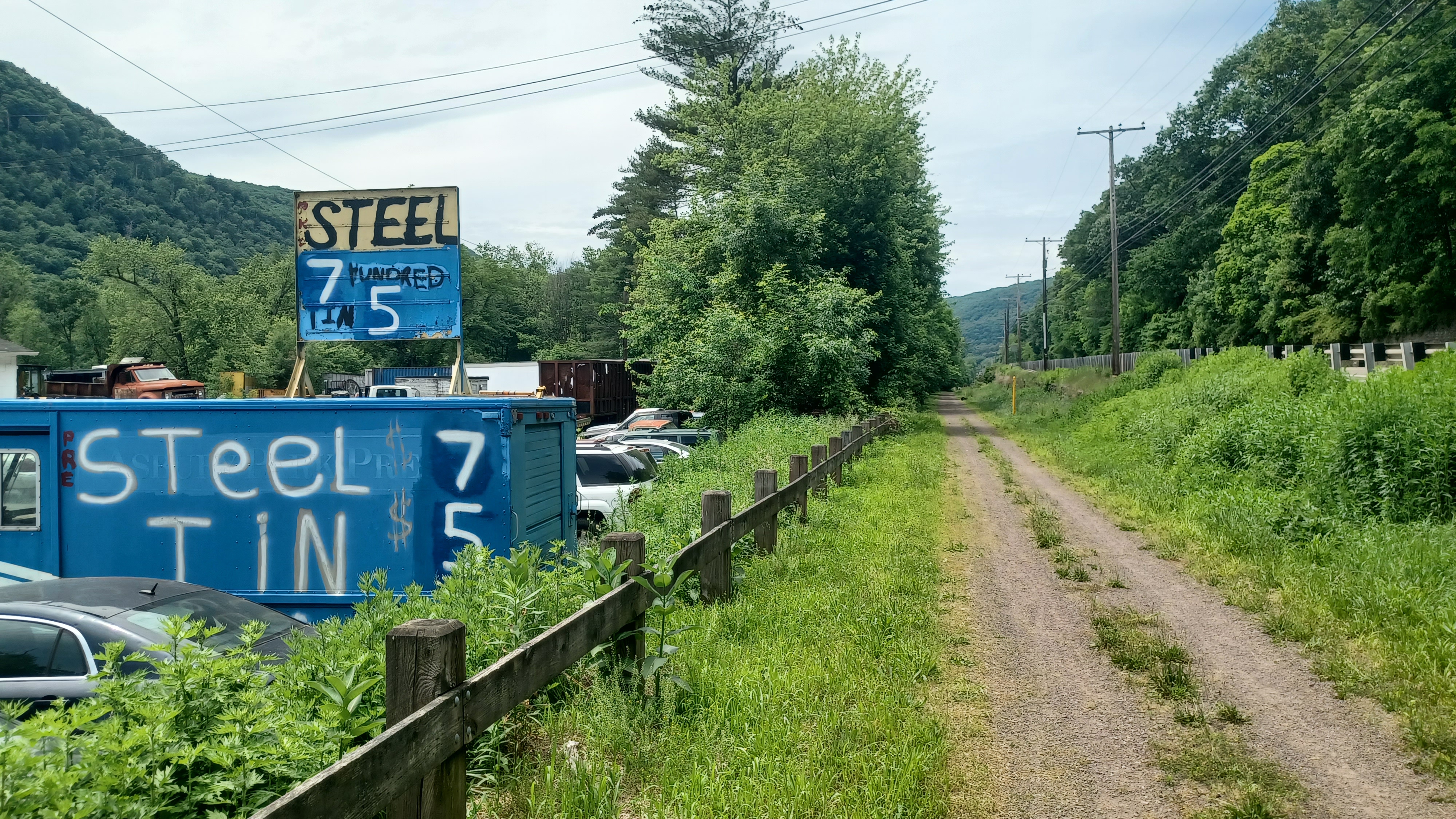
We came back to the edge of Rt 11, and passed some businesses including a scrap yard on the left.
There was a limo parked in front of one of them, and there were comments about it belonging to some recently ousted politicians.
Signs on scrap metal sales, and then an old jeep almost completely inundated with vegetation were directly along the edge of the rail bed. I think the canal moved back in close to the rail bed again, just after the scrap yard.

We sipped some Luzon Verde and watched as the canal came back into view on the left. It still had water in it, overgrown, but recognizable.

About where the canal moved back off to the left again, we approached the historic and nearly forgotten Hunlock Creek Station.
I had heard about this, and seen some photos of it before, but never been to it in person.
It was a sad sight to see, in a degree of ruin that is probably considered too far beyond repair at this time.
In order to save the building, it would have to be almost completely dismantled and man of the components of it replaced.
The station sat off to the left of the rail bed, not in its original location, on cinder blocks. It certainly looked too tall and larger than it should as we approached.

I at first did not think it was the station. It wasn't until I noticed the signature pagoda style roof that had become somewhat common of the time that I knew what we were looking at.
I believe the station was built by the Lackawanna Railroad about 1883, and it was situated just a little bit west of its current location, turned 180 degrees.
From the trail, the front left portion has completely collapsed. Most of the rest of it is in rough shape, but it still at least has a roof on it. Some of the somewhat recent photos I've seen of it didn't look terrible, but it's rough now.

We walked down a path to the left to view the building from inside the woods. It is sad to see one of the only remaining pagoda style stations just falling apart.

This one is actually pretty similar to the one that used to stand near in Oxford NJ near where I live.
From the south side of the building, we could look over a steep slope to the still watered North Branch Canal. It was quite a ways down the steep slope from the level of the station.
Someone had spray painted "left behind" on the edge of the station.
We made our way back around the building to the front, and I went over the historic photos I'd saved to my phone to do some then and now compilations before we moved on.

Some of the photos were more great glass plate negatives by Watson Bunnell, from the Steamtown NHS Archives, from 1910.

There were a few others at different angles. It was kind of tough at first to figure out exactly where the station used to stand. I knew some were taken from above, so I had to bushwhack up a bit.

There was a bridge straight ahead that carried the rail line across Hunlock Creek, and so the others took Ev over there to walk across it.
When I got to the top of the hill, there was a business directly across with yet another little flea market out in front of it. It was tempting to go and check it out, but I decided against it and continued with my photos.
After I got all of them, or thought I did (I missed one), we continued out across Hunlock Creek.
I had some other photos of the station building taken in 2010 by Joseph N Scherbenco, and I tried to emulate those as well. They were taken from where the station was moved to.

I told everyone to hold off while I went down to the creek, because I wanted to see about canal remnants.

Historic photos seem to suggest that the canal might have crossed a slack water with a spillway, because an adjacent bridge is shown across downstream, which would have carried a towpath.
When I reached the side of the creek, I waded in and headed downstream a bit. I didn't see any signs of any abutments in close proximity, but it certainly doesn't mean there was nothing there.
There was so much Japanese Knotweed that seeing anything would be nearly impossible.
 |
| 2010 Joseph N. Scherbenco |

As I walked, I did find some obvious cut stone remnants, which could easily have been from the predecessor of the railroad bridge that still stands, which is a more modern through girder one.

It's pretty obvious where the canal used to be looking at aerial images, but it was getting deeper and I decided not to wander down farther.
What was interesting to me however, was the underside of the railroad bridge. There was a sort of walkway along the edge of it, so I had to go and have a look.
I made a video as I walked it, beneath the rail bridge, and to where the walkway ended. I continued from there down into the water and beneath the bridge that carried Rt 11.

I saw something of another bridge on the other side, which I felt warranted some further exploration.

As I got to the other side, I found another sort of odd shaped girder bridge. I knew I'd seen something like this before.
It took a few moments to realize it, but this looked to be an old turntable bridge! There are places, such as on the old Bel Del line in New Jersey, in Holland Township, where an old turntable was lifted off, flipped upside down, and then used as a bridge.
This looked just like those types of things. The problem was, I had never heard of this before. Oddities like this are usually pretty popular among rail fans, but no one has ever said anything about it.
I posted the video to both Facebook and Youtube, but as of now, I still have not gotten a definitive answer. I'm pretty sure it is an old turntable though.
I made my way back up to the rail bed, after laying down in the water briefly. Hunlock Creek was freezing cold, and my brief dip in it was enough to cool me off for a while.
We got moving, and Ev didn't want to walk anymore, or leave the bridge. We had to get going though, so I fell behind and coerced him for a bit.

We continued on the rail bed ahead, and passed an electric substation with some really nice views of the mountains across the Susquehanna.

We passed by a sign on the way that read "stay on trail, keep moving".
This was certainly due to the nearby correctional facility across the river from us a little bit ahead.
The rail bed remained close to Rt 11, and after the clearing, the former canal came in close to it once again.
After a little bit, we approached the "Retreat Bridge", across the Susquehanna.
This historic bridge has quite an interesting story on how it came to be where it is sitting today.
This was the original Carey Avenue Bridge over the Susquehanna River in Plymouth Pa, built in 1894. It was replaced in 1948 by a steel bridge, which also was replaced by the current bridge in Plymouth, just upstream from the predecessor in 2002.
The Carey Avenue Bridge was taken downstream and erected across the Susquehanna and redubbed the "Retreat Bridge".
The property across the Susquehanna from here was established with the creation of the Central Poor District starting in the 1860s.
 |
| 1910 Watson Bunnell, Steamtown NHS Archives |

It became Luzerne County's almshouse. It served as a poor house under this plan initially, and the Central Poor District started caring for the insane in 1890.
 |
| 1913 Watson Bunnell, Steamtown NHS Archives |

In 1900, a hospital for the insane was established at this site. It became known as the "Retreat". By the 1920s, it was the Retreat Mental Hospital.


The site was rather inaccessible; the Pennsylvania Railroad went by it on the south or east side of the river, but there was little other vehicle access. In 1948, the original Carey Avenue Bridge was erected here.


The hospital dwindled as did funding, and starting in 1981, conversion began on a minimum-security prison on the site.

I had another historic image to emulate at this point, which was quite different. It showed the canal and the rail line. The Lackawanna at this point has been abandoned since the 1980s, and the canal closed in December of 1900.
We took a little break here, and I didn't dare go up to the Retreat Bridge, because it seemed like it was a rather high security place. John went right up to it like it was nothing.
I do understand that the place is in a sort of limbo right now. It's supposed to be reopened as some sort of low security thing, and I forget what the plans are, but it will be changing.
 |
| 2010 Joseph N Scherbenco |

We took a break in the grass near this point, and then continued back onto the rail bed.

The rail bed moved off away from Rt 11 for a bit, into a very pleasant section along the river.
There was a bench on the right, with warning signs all around it for a shooting range that is just up the hill from the spot. It seemed funny that the sign was placed exactly where the bench was.
We continued along through the woods, and sometimes the remnants of the canal and towpath were visible below us. I was amazed with the years of flooding that so much of this was still recognizable.

In fact, when we had first come down to the river out of West Nanticoke, I could see some of the stone supports of the towpath on the section looking downstream.

We made our way along the trail to the Union Township boat ramp below to the left. I noted the canal prism remnant on the way down on either side of the access.
It was getting pretty hot, and so if there was no one there, I wanted to take the opportunity to have a dip in the Susquehanna.
It was just perfect, and I went out in the water, just enough to get fully saturated, not get swept away, because the water was pretty strong further out.

I chose this spot as a good one for our group shot, because it looked good from the water with everyone together on the ramp.

After this, we headed back up the trail and continued our journey to the west.
We were still a good distance away from the highway at this point, and the next point of interest I had found when planning this hike was an historic cemetery just off the trail to the north.
This was known as the Miller Cemetery and the Search Cemetery for old local names.
We reached a side path to the right from the trail, which led in a short distance to the cemetery.

It was pretty old, and I found markers dating to both 1817 and 1819. We hung out and checked out some of the stones for a bit before heading back to the trail.

Soon, the trail came back out parallel with Rt 11 again. There were a few homes along the stretch of the highway, and there were a few homes along the side as we neared the town of Shickshinny.
Along this stretch, a black snake crossed our path, which was cool for Ev to be able to see.
There were probably once more houses located on the slope above the highway, because there were stone walls and such, and they've probably disappeared over the years.

It was a rather long stretch beside the highway until we got to town. The mile markers around mile 5 (which meant 5 remaining for us) had these sort of flowery phrases on them.

"Give it all you got" the first one we noticed said.
The rail bed moved away from the highway a bit when we started to enter the town.
We were soon directly parallel with Susquehanna Avenue. The canal came through town just below this on what is now Canal Street.
There is hardly a sign there were ever major pieces of transportation infrastructure here at all, because it is very unassuming looking grass today. The railroad station used to stand on the right of the rail bed, partially where the road is now it seems.

This area had some residents that dated back to the 1700s, but there wasn't really a very well established community until the street grid was laid in about 1861, after the railroad.

"Shickshinny" is said to be an aboriginal name, either meaning "place where five mountains meet", or "place of fine stream".
Either name would be appropriate, either for the clear Shickshinny Creek that flows into the Susquehanna in town, or for the mountains that come together in this little gap.
My plan for town was to stop for lunch at the Five Mountain Brewing Company.
We continued along the rail bed to the south for a bit, and I tried to get some historic photos of the sites around there.

There were some good historic markers along the way, with some stuff I could use, and I also looked up info about the town ahead of time.

To the right was the former Norman Bros. Ford Motor Company Garage, which served Model T Ford vehicles and the line from 1908 until 1927.

Today, the building is a Curry Donuts place.
There was soon an information kiosk for the trail that featured many historic photos of the town, as well as the railroad station, the tracks, industries, and more. I tried to get some of those to emulate.
We walked to Union Street, where ahead the railroad crossed the Shickshinny Creek, but we turned right out to Rt 11.
We made a right turn just a short distance, and Five Mountains Brewing was on the left side.
 |
| Detroit Photographic Company |

The place was a white house, with a welcoming porch, small tap room and seating inside, and then a very lovely outdoor back area that had a fire pit (not needed this time)!

This was perfect, because I could let Ev loose to run around without having to really worry about him.
Even better for us, the place was nearly empty. There were a couple of people inside having drinks, no one having food, so it seemed like it was idea.
The stroller barely fit through, and then wouldn't make it through the hallway, so we had to go out and around to the back.
We sat around deciding on our food, and I wanted to try to get something that Ev would eat, while also sampling some of their beer.


At first, I didn't really see anything that excited me all that much because their beers weren't all that high ABV, but I got whatever the strongest one was, and it wasn't bad at all.

It was nice to have any cold drink at this point.
What was really odd was that there was only one young girl holding down the fort by herself.
Five Mountains Brewing Company started out rather humbly in 2018 a short distance away. The owners started the business after trying to emulate a craft beer that was well loved, but a limited release. It led to the passion of brewing and trying new things, and then opening the business.

This business moved to its current location in 2020, which of course was a difficult time to do anything like that, and still did well.

The young girl working the place was the daughter of the owners, covering it all herself while her parents were away. She was a very pretty and polite girl, and it was surprising that more people didn't go in just to talk to her.
I felt guilty ordering anything complicated, and so when I went up to order, I was looking for something rather simple, knowing she was on her own.
While I was talking to her, she asked "well, what were you going to order?"


I had looked at something called the "Utica Riggies", which was a Rigatoni in a slightly spicy red sauce. I knew Ev would like the pasta, and that was why, as well as I thought it sounded good.

Immediately she said "Oh I can do it."
I asked if she had the stuff premade to make it easier to just heat up and put out. She told me certain base things they had made and refrigerated, but that mostly it was all fresh stuff.
She made it sound pretty easy, so I accepted and ordered that for Ev and myself.
This girl was definitely of the hard-working, eastern Pennsylvania stock. More folks showed up, and she handled everything in a seemingly easy fashion.


We sat in the back, and it didn't take very long to get our food. The Riggies I got were actually a bit spicier than I'd thought they'd be, but Ev still ate them anyway, and that's what my biggest concern was.

I was quite stuffed after my meal, and Ev was tuckered out pretty well.
The group started heading out; Dan was heading to a Dollar General I think it was to get some further sustinence, and the others would head directly back to the rail trail.
While they were moseying and getting together, I put Ev in the stroller and let the others know I would be heading back the way we came just a little bit in order to try to get a few more then and now history compilations.


As we had approached the brewery, I noticed a very interesting little church, built almost into the edge of the mountain to the left. I needed to get a closer look at that.

This was the First Presbyterian Church of Shickshinny Pennsylvania. May 2024 marked 160 years that the church has served the settlement.
I got a good shot of this, and we moved on ahead and got a shot of the coffee shop that occupied the former Ford sales place, which the sign said was a different business.
We then headed back up onto the railroad bed, and we backtracked to the station site. I confirmed where it was while we were taking a break by using some historic aerial images.


Additionally, there was an historic shot from a flood in 1904 that had badly messed up the tracks.

After getting these, we turned around and began making our way back in the direction we were headed. The rest of the group I could see crossing the bridge over the Shickshinny Creek ahead.
We crossed the creek, with very nice views of the mountains beyond. Matt was saying there was some sort of hiking loop that can be done on some of these mountains nearby, which looks enticing.
We continued across the bridge, and above the Family Dollar where we could see Dan approaching us with a bag of stuff.


We came out to the corner of Vine Street and Butler Street, where it looked as though the trail came to an end.

Some guy came up to talk to the group about where we were going, and trying to be helpful, he told us the trail didn't go through.
He explained that for whatever reason, they never built the trail through, and that we would have to turn right, go out to Rt 11, and head south in order to continue.
We acted thankful, but I didn't believe him. Often times, even people who live in the towns have absolutely no clue what is there.


I had checked into most of this, and I was fairly certain that the trail did go through, and that it just left the railroad bed for a short time here.

We headed east on Butler Street toward the river, and there was a playground on the right. I decided to let everyone regroup and let Ev play on the playground for a bit while I looked at the maps.
I think I saw one of the mile markers for the trail in this area, which sort of confirmed to me that the trail went through and the guy who was telling us to go to Rt 11 didn't know what he was talking about.
The spot along the river in this area was the former canal, apparently covered over in this spot.


After the break, we continued following the river through Shickshinny Park. This took us to the south side of the park, which is called Bridge Street. I can only assume a previous bridge crossed here.

From here, the trail did indeed continue into the woods, pretty much on the historic route of the canal rather than the railroad, but it was hard to see anything. The entire thing was a narrower path inundated by Japanese Knotweed.
It had started out just a grassy clearing, which appears to be the route of a buried utility, but then got to be quite thick.
It's a good thing it hadn't been raining, because it would have been like walking through a carwash. There was no passing through without leaves brushing against us, but that's just how Knotweed is, with how fast it grows. The treadway was still fine, and quite easy to push the stroller.
Pretty soon, we passed beneath the bridge that goes across the Susquehanna to Mocanaqua.
I had been there only once before. We had done a hike almost two years prior where we went from Sugar Notch area to this point. The end of it had been quite rough heading through some of the western reaches of the coal fields. I really want to get back out there and explore some more, because there are so many more trails, but it will require a bit of planning. It looks like it'd have good swim spots, but it also has potentially rough terrain, and I don't want to be out there stuck late with Ev.

After the bridge, the trail turned hard to the right, and started to climb toward the railroad bed again. There was not really anything of the canal we could see through vegetation anyway.


This part got insanely steep, and I needed some help getting the stroller up it. It is certainly not intended that cyclists go up and down this either. I suppose it was the only way through for the trail.

In a short bit, we got right back on the railroad bed, which was directly beside Rt 11 again, and continued. At this point, we were heading more south.
We still had almost five more miles, but it started to feel like the home stretch, and it was quite relaxing aside from a bit of a tummy ache from too much food.
Soon, there was a foot path down to the river to the left, and so I held up and had the others watch Ev while I went down to have a closer look.
 |
| 1904 Flood |

Of course, I wanted to see if there were any canal remnants, and I did find rip rap rock walls that would have held the canal.

It was a narrow section of the river, and so much of this was certainly prone to the damage from flooding, which was why it wasn't so recognizable as previous sections.
Soon however, we were moving inland a bit from the river, and so did the canal. Below us to the left, we could start to see how the canal was again full of water, and even the towpath was somewhat clear.
I noticed in a bit that there was a stone structure, which might have been either a bridge abutment, or a sort of weir site where the canal could be blocked off for maintenance of certain sections.


The canal became wider, like a basin, just ahead of this. I don't think the structure was a lock, but it's possible. Sometimes much of the lock stone is taken and reused elsewhere.

An entrance to another salvage yard, a sort of theme for this area I guess, was just ahead, and the trail had some foot bridges over a small wetland. The highway may have encroached on the rail bed in this spot.
We paralleled the salvage yard for a bit, and the canal was somewhat filled directly beside us to the left.
The trail mile markers passed 2.5 remaining, and each of these posts were adorned with flowery sayings again.


Soon, the right of way was lined with different kinds of junk from salvage yards. We then came upon a house, which uses some of the right of way as a driveway, with lots of old cars around.

This place was pretty interesting, and it had all sorts of stuff out in the yard fenced in. It looks like it must be another sales area or something.
Among the stuff was a table made of a couple of boards sat on cinder blocks, and on top were lots of old metal tow trucks. They were somewhat protected by a little roof made by putting four sawhorses on top of the table with sheet metal or something on top.
A little bit past this area, we passed a trailer that read "Christopher Motors", which had more stuff piled outside. It was unclear whether or not someone was living in this.
Although it was the trail, there was the feeling that we weren't supposed to be there. One of the more odd areas for a trail.
The stuff continued to line the trail for a while after we got back into a more wooded setting.
The canal came back into view, although dry, and there was a washout in it to the river below. This might have been a wrecked former weir site.
A little bit after that, the rail bed opened up into a mow mowed off section, and the canal became more obvious on the left. Pretty soon, it was watered, in a beautiful section.

This area is apparently once a settlement known as Dogtown.


There were no trespassing signs along the canal and in all lands to the left of the rail bed, but the watered canal and towpath were beautiful here.


We continued on behind Titan Auto Sales, and the watered section of the canal ended. There was a little private pavilion along it, and seating, probably owned by the folks across the rail bed.

We entered the woods again on the other side, and crossed a little bridge over a small stream.
The historic canal route parallel with us became a mowed route. It seems that after we crossed that creek, we were in the property of the Susquehanna Riverlands.
The entire tract of land was one of those power company owned preserves created as sort of incentives for allowing the power plants to be built. The spot where we had parked had a visitor center that once had a scale model of the nuclear power plant built nearby.


After 9/11, all of these power plants had to raise their levels of security. Many of the plants had scale models of their operation, and I have fond memories of visiting the ones at Merrill Creek and Yards Creek in New Jersey.


There was a red shed on the right, and then the feel of the trail changed a bit. It went into more woods, and shifted off of the rail bed a bit.

To the right, and inside the weeds, tracks appeared. This was apparently left in place from the days when larger trains would serve the power plant and needed backup space.
We continued through nice shade, directly beside the tracks for a while, and they soon became somewhat clear again, with only occasional vegetation growing through them.
Soon after that, we came to the junction where the spur went off to the nuclear facility.


It wasn't much further from here to get to the entrance road and the Talen Energy building where we had parked in the morning.


There is a whole lot more to see in the Susquehanna Riverlands area here. Ahead from where we finished, the towpath is clear and the canal watered.
The railroad tracks continue in place heading south from here, and are considered still active, although small shrubs are growing through them heading to the south. Ev was enamored with the railroad tracks, and kept pointing and saying "railroad tracks" for the final leg of the hike there.
The preserve has two different trails along the river side, one apparently along either side of the canal, and I'm not sure how far it goes. There is at least about two miles further we could go to the south on it.
I had originally thought to just go to the south end of this preserve, and then instead considered just adding that to the start of the next hike I do in the region.
I want to continue hiking along the Bloomsburg Branch down to Berwick and beyond, but with the tracks in place, that makes it harder. I would definitely be doing it almost right away, but I have to take the stroller into consideration. Even if I could get it along some of those track sections, later Summer days are bad for that because tracks get loaded with yellow jackets. As of this writing, Ev still has never been stung by a bee or anything much more than a mosquito bite yet, and so I don't want to be out in the middle of some inaccessible place the first time it happens and risk serious injury or even losing him.

I've gone over maps and might have an early fall trip that would be appropriate for this next one, but for now, I am happy that we got this section done during the right time of the year.
No comments:
Post a Comment