

Hike 1602: 4/21/24 Haverstraw Bay to Nyack with Matthew Davis, Jenny Tull, Gregory Andre and Saga, Diane Reider, Robin Deitz, Mike Selender, Serious Sean Dougherty, Olga ?, VK ?, and Everen

This next hike would be another point to point in our Hudson River Greenway series that I'd somewhat recently re-started.
I'd so very much enjoyed the trips we had done between Cornwall On Hudson, Bear Mountain, and Haverstraw, that I wanted to continue with it a bit. We had also recently re-done some of the old Erie line below Nyack, and so I felt we'd done that as well. I wanted to make another connection to the Nyack area from the north.
By doing this, we would have essentially walked along the entire west side of the Hudson all the way from Cornwall on Hudson all the way to the tip of Bayonne.

Like the previous trips, there was a whole lot to see between road walk sections, and even more dedicated trail than on some of the previous ones.

I wanted to try to physically tie this in with my previous hikes as best I could, and so I made the meeting point Village of Nyack Memorial Park. I had done a hike back in 2011 or 12 that used this as a meet point for a loop on the Long Path and the Old Erie Path.
When I go up to Nyack and Matt, Ev and I were almost to the meet point, the parking and access to the park was fully shut. I'm not sure if I might have missed some participants that didn't know where to go, but we couldn't park near where I was planning.

In order to use the park, we had to park nearby at the Nyack Municipal Boat Launch. Fortunately, we were able to get most of who I was expecting to be there together.

The starting point at Haverstraw Bay Park was where we had finished the last one, and my only concern was that it closed at dark and had gates. If we ended up taking any extra time, it could be bad.

As we parked in the park and started getting out to leave, we were immediately accosted by a park employee. It turns out the park does not permit dogs, but Greg was there with Saga. We explained that we were not planning on staying in the park, but that we were going to be hiking to the south along the Hudson River Greenway. He let us go and was friendly enough.
It had been my intention to walk with the group on a loop around the park there, because it's a really pretty waterfront, and I'd done it the last time.

Unfortunately, we didn't want to overstay our welcome so we continued on our way toward the park exit on Gagen Road.

In a short distance, we could see old abandoned railroad tracks crossing the road. This was a long former spur from the West Shore Railroad to the west of us, which served a Gypsum plant to the north, and power plant or something to the south.
On the north side of the road, the railroad bed was covered over by a crushed stone aggregate, as if it were to be made into a trail, which leads all the way out to Beach Road to the north.
There was a trail that went to the left, parallel with these tracks, and then to a pier out onto the pond on the south side of the park, the one I'd not been to yet.

We just about reached the pier I wanted to check out, which was only an out and back walk anyway, when the same park official followed us in on a UTV.

He wanted to know what we were doing for certain, and why we were still in the park with the dog. We were friendly, and so was he. I just explained we wanted to see all of the stuff on the way, and that I'd not hit that spot yet.
He wanted to make sure we knew that it was not a through route, he said, which is appreciated.
I took the opportunity to ask him what was going on with the railroad bed that looked as though it was being made into a trail. He explained that it was not to be a trail, but rather a temporary road.

The bridge over the Cedar Pond Brook on Gagen Road, the only access to the park, was to be closed for replacement, and the railroad bed was to serve as the road access to the site during that time.

We checked out the views at the dock, and were soon on our way back to Gagen Road, where we turned to the left and continued across the Cedar Pond Brook.
Soon, we reached Rt 108, Beach Road, and turned to the left.
The road went close to the Cedar Pond Brook, and then closely skirted some businesses.
We soon came to the intersection with Railroad Avenue, and Pecks Pond Park, where we turned onto part of the loop trail around the already scenic pond.

The trail went to both the east and west sides of the pond, but it looked as through the west side would be more private than the one right beside the park road.

This is an interesting spot for railroad history, even though there's not visible now.
The tracks are still in place from that spur from the West Shore, which at this point was out in the woods a bit to the west. I had wondered if maybe we'd be able to follow that, but it looked as though it was all fenced in in the section beyond the park.
At Pecks Pond, on the west side where we were heading, the New York and New Jersey Railroad used to have a spur that came right up along it. Apparently, the trail on that side is a bit of that grade.

This line reached the Village of Haverstraw in 1887, after traveling from New Jersey. It is still active up to Spring Valley, and abandoned to the north. It traveled through to Mt Ivy, and then over to Haverstraw where it had spurs to local industries, most importantly, the brick industry.
Passenger service ended on this line in 1939, and the norther section into Haverstraw was entirely abandoned in 1940.
It is interesting that the line had this northern spur along Pecks Pond, and another spur came from the West Shore line, but neither ever connected, and it looks like they never even coexisted, despite their rights of way being within sight of one another.
We continued along the north side of the pond, and then south along the west side, on what was likely the railroad bed.
In this area, I popped a new drink I'd never had before from something called Lough Brewing Co, called Dark Majik Imperial Irish Oatmeal Coffee Stout. It was actually pretty good.
As we walked along the edge of the park, we had some good views straight ahead of High Tor, the local promontory on the Palisades formation. The formation is composed of igneous extrusive basalt that stretches from the south side of Bergen Hill at the Bayonne border in NJ, all the way to Mt Ivy NY.

We also had a very good view of the power plant just to the east of the pond where that West Shore spur terminated.

When we got to the south side of Pecks Pond, we reached the Village of West Haverstraw municipal offices and public works.

My plan ahead was to do an out and back onto Bowline Point Park, which has a great deal of history to it, but I made a slight mistake at this point.
We could have turned left on Bowline Plant Road, which would have led to where I wanted to go, but I saw an open chain link fence. I figured we wouldn't be able to get through.
The mistake ended up being a good one in the long run. We turned to the right on Bowline Plant Road briefly, walked through the grass on the edge of the road, which is very close to where the NY and NJ Railroad ran. It followed parallel to the Minisceongo Creek, which was just to the south of us for a bit.

We turned to the left on Samsondale Avenue and crossed where the Bowline plant spur would have been, and then headed somewhat uphill a bit to reach Broadway, where we turned on Broadway.

The railroad was established in 1866 as the Hackensack and New York Extension Railroad, and became the New Jersey and New York Railroad in 1878. It was leased to the Erie in 1896.
We started to head into downtown Haverstraw, and the main line of the NJ and NY Railroad went through an industrial property to the left, spun around, and then crossed over Broadway. It passed through what is now a track at a local school which was the terminus of the main line. The farthest east spur was what went out to Bowline Point.

We crossed where the tracks would have gone, but I didn't notice any obvious remnants.

We continued ahead, and passed I think it was Hershey's Deli, where we paused to get some food and drinks along the way. I don't recall exactly what I got, but I definitely did get something for Ev and I.
Along the Broaway section, we also passed the historic St Peter & St Mary's Church of Haverstraw. Originally St Peters Church before a 2016 merger, the Church was built in 1869 of locally made brick, for which the town was known the world over.
The brick industry of Haverstraw began in 1815 when James Wood used the area clay banks on the lands of John Denoyelles to begin making product.

After a nice little break, we continued ahead to the intersection with Warren Avenue, which turned steeply to the left on Warren Avenue.

This brought us down to where there was a good trail along the right side of Bowline Pond, but that would be what we'd follow later.
My plan was to head out to Bowline Point itself, which is a nice park, and I figured this was the way we had to do it.
We turned left on McKenzie Avenue, which went north and connected with the Bowline Plant Road, and the chain link fence was open on the east side. I could see directly back to where we had just been a little bit ago. It would have been way shorter, but we wouldn't have had a chance to see more of the railroad grades, and we wouldn't have gotten to stop at the deli or see the church or bit of downtown, so I was happy with how it went.

We kept to the right on McKenzie Avenue, which had a good grassy swath on the right side, so it was fine for walking with the stroller.

It was a really very comfortable temperature, and Ev and I were wearing our new Metrotrails hoodies that my step dad Mark Godfrey had gotten us the night before. It was perfect temperature for them.
I was a little concerned that entering this park might be a fee area or that it was something that would be closed to pedestrians or even dogs entering, but it worked out for everything.
We made our way to a toll booth, because a toll is collected in season, when there is swimming at their pool, but we were early enough in the season for it not to be an issue.

The giant peninsula has great views and quite a lot of history. We immediately got through the gate and went to a little waterfront beach with a pipeline going in from some industry.

The modern-day peninsula was once connected land, and the Bowline Pond on the inland side was a clay pit, where clay was excavated for the 40 brick yards that once operated in the Haverstraw area.
Clay was fired for creation of bricks, which served the enormous growth of New York City and other areas up and down the Hudson River. Haverstraw was known for its brick making from about 1890 till World War II.

The area was originally called "Bull Line" because of of the "Bull Engines" that moved material around on narrow gauge tracks at the site. The accents of immigrant workers at the site altered it to "Bow line", which is also a knot used in the shipping industry.

I figure there is some sort of relation between the small engines that were used here and the first regular operation locomotive on the Camden and Amboy Railroad, known as the John Bull. Maybe at one time all similar engines started carrying that name? I'm not really sure, but it is somehow tied to the naming of the property.

The New Jersey and New York Railroad traveled at least a good distance around the outside of the pond, but I didn't notice any very obvious remnants of the spur. It's probably been landscaped completely out of existence.

Brick manufacturing at the clay pit here ceased after a major deadly landslide occurred in 1906.

The land mass separating the old clay pit from the Hudson River was removed in the 1950s. The park now has walkways, playgrounds, and the giant swimming pool was complete with long and tall slides.
Just after the look at the waterfront, we went to the first playground where Ev got to run around for a bit.
Soon, we continued along the paved pathway that continues along the east side of the park, on the Hudson waterfront.

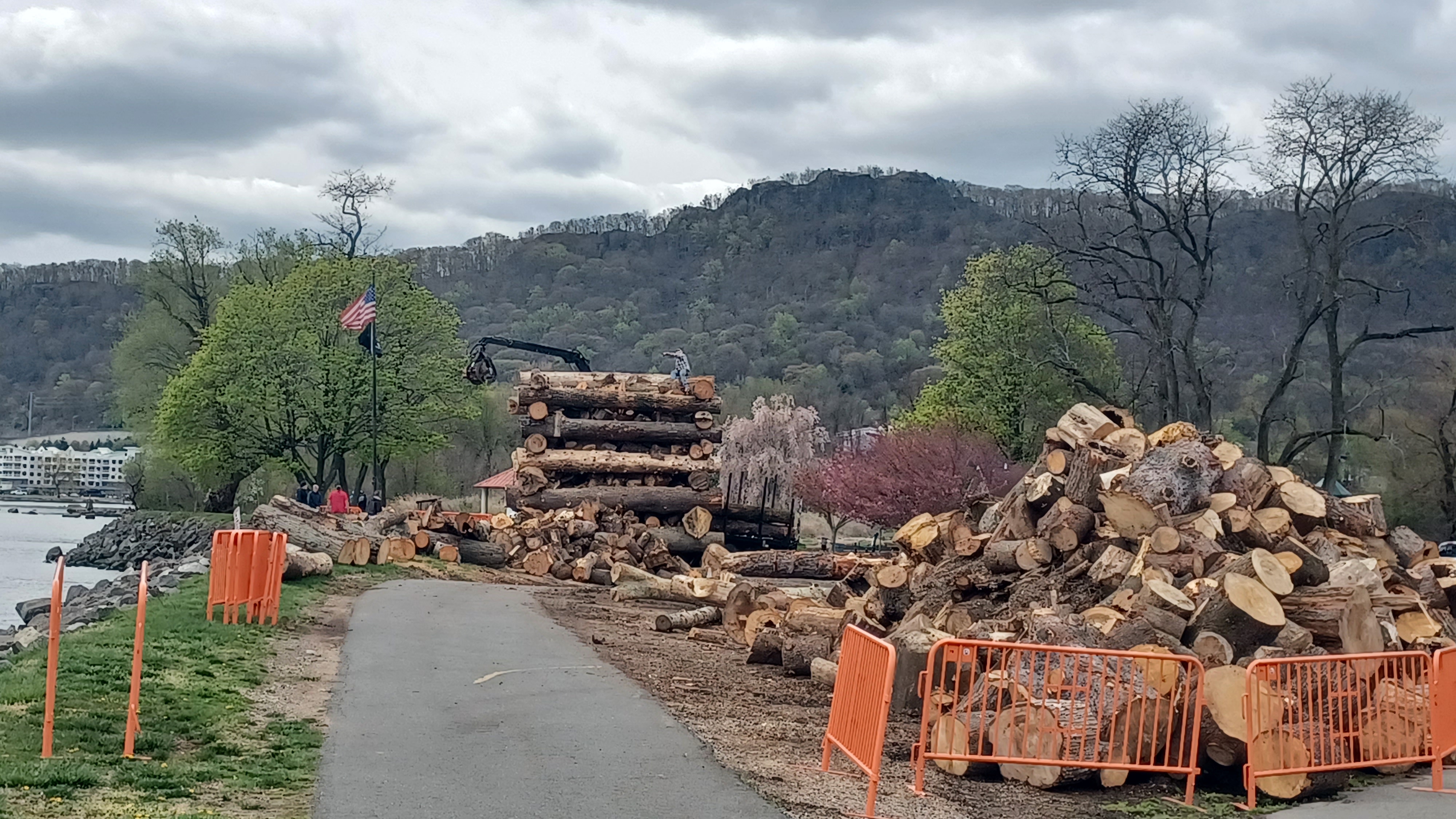
As we walked, there was a closure of some of the path, and then giant piles of wood all over the place.

Ahead, there was a large machine placing the logs onto an odd Lincoln Log style thing.
This looked particularly interesting, and although the first bit of the path was closed, we were able to go around on open ones and get a little closer to see what was going on.
A guy working on the ground area was there to answer our questions on all of this.
We were witnessing the construction of a fire pyre for upcoming Memorial Day weekend, which is a traditional thing up and down the Hudson River.

Watchfires originated with General George Washington lighting bonfires along the Hudson to alert his soldiers of the movements of the British army. Additionally, he used them to signal ceasefire at the end of the American Revolution.

Every Memorial Day, watch fires are lit along the Palisade formations including here, Piermont, and others, symbolically lighting the way for soldiers of all wars and conflicts of the United States.

The guy we were talking to said that he got involved with this process through his father, and encouraged us to look it up later when we got home (I did).
The guy up on the pyre was climbing around like crazy with a chainsaw, and I was rather awe struck by the amoung of work happening in such short order.
It was obvious that this volunteer organization was held in high regard, because it looked like a sort of blind eye was turned for some of what would be crazy safety concerns for government employees.

Climbing around as they were, with these huge logs, with a chainsaw but no chaps or helmets. Mostly older guys, they knew what they were doing, and the skill level was far above mine.

We had a nice talk, and watched them move a few of the logs into place on top, then continued on toward the end of the Bowline Point peninsula.
From the end, where there was a nice carousel shaped pavilion, we had a great view down the river toward Long Clove, as well as the near end of Hook Mountain. High Tor was well in view closer.
We started walking back along the Bowline Pond side, and I was rather surprised at the signage that warned of "absolutely no rock throwing", as well as no swimming and no watercraft of any kind.

I suspect that this is because the area is still very shallow, even with the river connected, and it may contain some sort of unexploded material from its previous industrial days.

In a short distance, there were some ruins of one of the old brick buildings I assume, or maybe just a pile of bricks that had never been shipped off. There were signs saying not to climb on them, but Ev was all up on them.
There were beautiful west facing views walking around the edge of the pond area, and then there was a nice wooden dock we could walk out onto. Ev walked just about all of the entire length of Bowline Point Park himself and remained energetic through the entire thing until we got to the exit again, where I had to put him in the stroller to head back into trafficked areas.

We headed back along McKenzie Avenue out along the peninsula, and then past the entrance to the Bowline Plant Road to reach Warren Avenue where we had turned before.

At this intersection, there was a cute little church or chapel building on the end of the road.
This is known as the Chapel of Our Lady along Bowline Pond.
The structure was built in 1936 by Nicholas Sansonetti on land provided by the owner of Archer Brickyards.
The Festa, an annual celebration, is held usually Labor Day weekend and draws large crowds. There's a lot to this celebration, which has moved to other locations over the years because the little Warren Avenue area was something it outgrew, but now they apparently do celebrations again there.

The chapel is now municipal owned but only open on days of celebration.

The paved trail broke off from Warren Avenue within sight of the chapel. It was a really nice section that can't be all that old. It doesn't show up on the bicycle trail function on Google Maps yet.
I wonder if any of this was some of the bowline locomotive right of way. It is an obvious shelf along the waterfront on the east side of the Bowline Pond, but I'm not sure.
None of the historic USGS maps seem to show any smaller gauge rail lines along the pond, just the connection from the NJ and NY line.

We continued around the outside, with good views to the pond, and where it was opened up to the river.

We paralleled Jefferson Street, then the trail turned south again, and emerged at the top of Liberty Street. I thought maybe we'd have access to the other end of the peninsula of Bowline Pond, but it was fenced and posted not to enter.
Liberty Street came out to Broad Street where we turned left, and then soon turne right on Allison Avenue.
We turned to the right from this onto a side road at the intersection with Front Street, which led down to Emeline Park right on the Hudson.

There was a giant heap of dirt where we turned by the fence, and rather than go out and around at a switchback for the roads, Serious Sean went over the edge of the wall and jumped down onto a dirt pile.

The park is so named supposedly because there was a paddle wheel steamboat that one operated and had a landing out of what is now the park, and it was called the Emeline.

There was a nice walkway through Emeline Park along the waterfront.
There was a little playground where Ev could stop and play for a bit, but he had fun moving bricks around that had been laying in the park.
As we approached the end of the park area, there was a cannon and a memorial pointed down the river to the south.
This cannon is supposed to be aimed at the historic Benedict Arnold treason site from 1780, which we would visit pretty soon on the hike.

There was a set of steps up from the waterfront when we got to a restaurant on the south side, and then we had to walk a bit of First Street to the south.

As we walked a bit more, near the corner of the street where we turned ninety degrees to the right, there was a marker denoting that this is the widest spot on the entire Hudson River, over 19,000 feet.
The turn was on Elks Drive, and we tried to go through the Elks Club parking area to cut a corner. I think most of the group was able to get through on that, but getting the stroller through was not going to be easy.
I told the others to go ahead through whatever way they could, and I would go around. Still, I ended up falling behind the rest of the group because of this.

We continued downhill a bit on West Avenue, and reached the intersection with Maple Avenue. There was a large sculpture here of a face with bricks inscribed with "TRUTH" on them.

My plan from here was to turn left to the Ossining-Haverstraw Ferry landing, on a side road parallel with the Admiral's Cove development on the waterfront, because it has walkways through it.
The group all missed this and continued walking ahead, so I went with just Ev out to the left to the ferry landing and skirted the edge of a cove to the north.
I got hold of the group and let them know they missed the turn, and so they turned to try to intercept me a bit along.

I passed the ferry landing, after a really great view of the widest spot on the Hudson.

There have been ferries across the Hudson for years, but I understand this particular one, at this particular spot, is rather new, and I want to say it opened in 1997.
Just after passing the ferry, I found the rest of the group at the start of the paved walkway along the waterfront.
This was a particularly excellent section. Matt mentioned that this section reminded him much of the Port Liberte near Liberty State Park in NJ, where he had hiked with me many years before in 2009.

He was right, and particularly so when we got to the first cove area and there was a footbridge over it.

There were art installations along this trail, including three sort of wooden totem poles, each representing love, hope, and truth. I noted that they also represent boobs, because each pole had prominent exposed breasts.
Ev got out of the stroller and walked through a lot of this section again since it was so nice. He loves bridges, and so the substantial pedestrian bridge over the cove was perfect for him.
We walked around the outside of the cove and back to the waterfront where there was more artwork, and then a nice historic marker on the Erie Canal and the commerce it brought the area.

People don't always consider that the Hudson was part of this major waterway, but the fact that the Hudson is tidal and navigable all the way to Albany is somewhat often overlooked.

The Erie Canal began construction in 1817, and was completed in 1825. At that time, so much extra freight came down the Hudson than ever before, and all of the towns on the way benefitted.
There was soon another historic marker denoting that this area was the brick making capital of the world.
We continued on the waterfront, and it remained beautiful through to the end of the walkway. The views of the different Palisade formation peaks ahead were splendid as the development ended.

We turned right at the end, and the walkway terminated at Riverfront Lane. We just continued straight through the grass along the edge of the development.

Riverside Avenue was way above us in this area, and we could see there was a grassy slope that I should just have been able to get the stroller up.
I asked the group before we pulled over to the road to stick with Ev for a few moments, as I just put him back in the stroller, while I ran off to the edge of an evergreen tree line to take a much needed pee.
I saw the group was pushing him up the hill without me, which was nice because it was such a chore getting it up slopes. I also like seeing it because then they have an appreciation for how difficult it is to do this all day on these things, but how I do it because it's worth it.

We reached Riverside Ave, after I took over nearer to the top of the incline, lifted the stroller over the galvanized rail, and continued left along the road.

There was only traffic really on the road until we got to the Short Clove Road intersection. I had hiked through here once before years ago, and I seem to recall some of the interchange work under construction.
Riverside Avenue took us onward past the quarry operations, with a bridge structure across along the way. The road walk is the necessary connection to continue on the Hudson River Greenway.
After the quarry, there is a rather obscure little community of homes known as Dutchtown.

 |
| West Shore RR station, Haverstraw |
 |
| 1872 switchback rail through Long Clove |
When we neared this, we first reached the Dutchtown Playground, where we stopped so that Ev could come back out and enjoy it a bit.

The community was only three tenths of a mile long, and then the road became a trail, closed to traffic from this point on to the south.

This is a fantastic section, because it is a five mile, unbroken section of undeveloped trail, with no road or railroad along the way. It is one of the only places on the entire Hudson like that. Most areas have railroad on either side, but the former West Shore line goes inland on the south side of Haverstraw.
That line was established as a competitor to the New York Central in this area in the 1860s but was soon taken over by that system.
It starts in Weehawken New Jersey and remains on the west side of the Palisades formation until the area of Hook Mountain, and then follows the West Shore of the Hudson North through Albany.

Interestingly, just around Dutchtown, the Long Clove was the route of a switchback railroad starting around 1872. The three mile route over this dip in the Palisades formation was necessary until the completion of the permanent tunnel.

All of that infrastructure spared much of this area ahead from being too badly developed in more recent years, but that wasn't always the case.
We reached the end of the public road and gate, and began walking the abandoned continuation of Riverside Drive to the south.
Pretty soon, we came upon the historic marker on the left side.
The marker denoted the location of the treason site, south of Haverstraw, in Haverstraw Beach State Park. Benedict Arnold met British Major John Andre in 1780 to plot surrender of West Point. Andre was caught and hanged. Arnold joined the British and escaped.

I had hiked through here once in I think it was 2011, when I was doing my series on the Long Path, and I tried looking for the "Treason Rock" below the main old road, but never found it.

Part of my goal this time was to take the side trip down and actually find the historic rock.
 |
I recall at the time that there was an unmarked trail or something that went down to the site, but this time there was a white blazed trail that reached the site.
The trail followed some sort of an old road route. I left Ev on the trail above while Matt, Greg, and I went down to have a look at the shoreline.
The entire area was strewn with lots of debris. Old wood and junk was all washed up, and I wasn't sure what rock was going to be the one. I understand that sometimes, the rock we were looking for would be under water. Maybe that's why I didn't find it previously.
I'm a little confused about the rocks down below, because I've heard of the "Treason Rock" and I've heard of the "Spy Rock". I've seen them labeled on maps. Are they both the same rock, or are they entirely different rocks near one another?
I still have not gotten a definitive answer, but we did find the "Spy Rock".
The large boulder in the dry tidal areas read "Andre the spy landed here Sept 21 1780.


I was content having found this, and we made our way back uphill. Much of the group just stayed at the very top of the slope while we explored there.

The area we were passing through ahead was once known as Snedeker's Landing.
We continued along the trail ahead, and had some nice views out over the Hudson River.
After a little bit, some ruins started to appear to the left of the trail a bit. The first one was a little lower than the trail to the left. It had angled sides, and looked similar to other park buildings from the earlier 1900s. This one appeared to have been a former restroom or comfort station.


We continued on along the road ahead, and soon there was an abandoned building on the left, which I had been to the previous time I was out there.

It is amazing to me that the structure had not been demolished yet, based on the condition of it.

I understand that this building, at a high point along the road, was once a park office of sorts.
The park was developed at some point soon after the acquisition of the property for park land here about 1911. It remained open until some time after World War II. There were swimming beach facilities below up until that time.
We approached the building, and there was apparently parking just beyond it at one time, judging by the widening of the old road.
The buildings had sort of angled edges with likely false stone facades (definitely in the case of the office building).

This was a sort of park brand look at the time of its construction. Many of the structures in Harriman and Bear Mountain State Parks have similarly shaped buildings scattered throughout the parks.
The building bore signs that it had once been on fire, which is probably why there is no roof and mostly no floor through the building. The roof over the main part of the structure is gone.
The floor in the main section is also completely gone, and only the entrance from the south side has any floor and roof remaining over it.


The section where the floor was still in place was also collapsing badly, and the doorway from that side had a few metal bars placed over it to keep people out.

Some char from whatever knocked out some of that side of the building could still be seen on some of the edges of the wood inside.
A set of stairs led own from the south entrance, possibly to former picnic and beach grounds toward the river below.
I'm really blown away that this building wasn't either demolished, or any of the remaining components of floor and roof were not removed for liability purposes. Still, I'm glad it was there for a little interesting exploring.


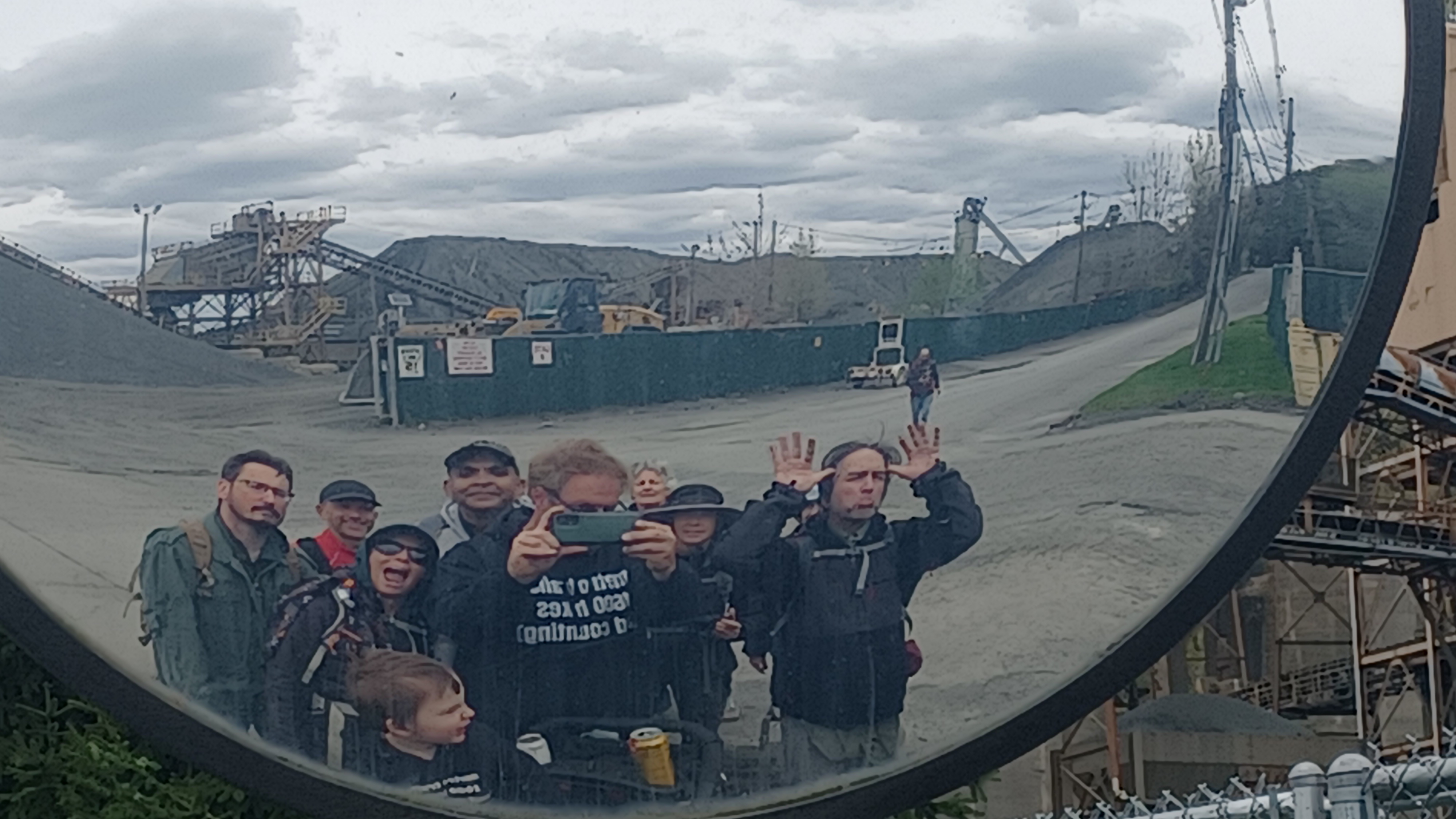
We got our group shot on the south side of the building, and then headed to the south. I was feeling good; Sean gave me some sort of really excellent beer that was extra strong a bit earlier, and I was feeling the effect.

We continued walking, through where the parking area had been on the road from the park office.
It seemed to me that the through road probably used to cut off at this point rather than go through during the years of park operation. It probably hadn't been a through route since the state took it over.
There were more walls and such along the trail as we continued on, but it's unclear if it was part of the park development, or the earlier Wilson Perkins Foss stone quarry operation.


I believe most of the park buildings with their similar signature earlier 1900s looks were part of the WPA projects (Works Progress Administration which included Civilian Conservation Corps).
Just ahead, we came to a spot with a sheer rock walk up to the right. Some of this was quarried out, but some is natural Palisade formations.
For a while after the office building, Ev walked the trail. Of course, he had to try to pick up just about every rock he saw, including ones far too heavy for him to lift.
It's really funny that even well before this hike, he had been testing his strength and trying to pick up the absolute largest rocks on trails everywhere.


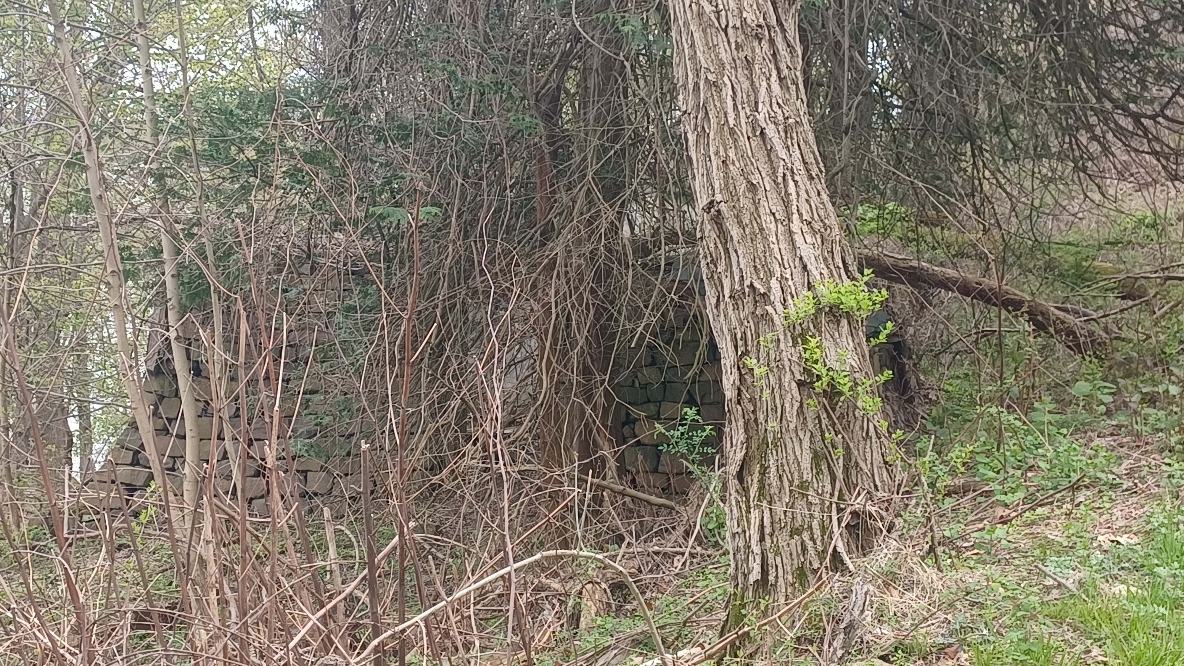
We gained some elevation and went around some corners, and then came to a bit of stone ruins off to the left, on the river side of the path.

Some of this, as I understand was remnants of the Foss Stone Crusher, which was abandoned some time in the very early 1900s.
It was definitely the right time of year to do this section. Foliage was just starting to come out, but we had near continuous views through the trees of the Hudson River below. If we'd waited two weeks, it would have been much different.
We saw some more bases for quarry operations, went around a corner on the old road, and then came upon a collapsed building on the right side.
I thought I recognized this site, and took a photo of it.
It turns out I did know the structure well: it too was associated with the Foss quarry operation. It was a sort of blast shelter that protected quarry workers against rock fall situations, and landslides resulting from these blasts from above.
When I was there a decade ago, the building was still somewhat standing, but the masonry work seems to have collapsed under the weight of the roof.
It was sad to see the more than century old structure collapsed, but there was no interest I guess by anyone in saving it. Most people going by would not even know what any of these remnants were. There was not a single historic marker interpreting any of what we were seeing.
 |
| From my past hike |

I had gotten a photo of the structure when I walked through I think in 2011 or 12, and it at least shows what the stone work in the front of it once looked like with the doorway.


We continued around another corner, and there was a remnant of what appeared to be a road side spring.

The beautiful trail afforded more views ahead as it passed over undulating terrain along the slopes.
Soon, we came upon another collapsing building up on the slope to the right. I questioned whether it was an old park building, or if it was something from the earlier quarry operation again.
Upon further inspection, it was definitely a park building because it was in the same style as the previous ones we'd seen, with the sloped rock at the bottoms. I had a photo of this one too, before it had collapsed on my last trip, although it was in rough shape then too.
There were a couple of places on the trail with fences and such, because there had been collapses of the slopes on the road over the years.
As we approached an area along the Hudson known as Verdrietege Hook, another abandoned building ruin came into view below us to the left. This one must have been part of the similar Nyack Beach State Park stuff we'd seen earlier.


Just past this spot, there was another giant concrete base sort of thing on the left, which might have been either park or quarry related. It was much larger so it could be quarry.

Pretty soon after that, there was a very obvious old park building on the right side.
The building had slanted edge walls and no roof or floor remaining.
This was certainly part of the original Nyack Beach State Park dating back to 1911. This infrastructure probably dates to a while after that.
Like the other areas, this was out of commission by the end of the 1940s when a storm caused major damage. It only lasted a bit of time after that.


The building had bars across the front door, and on the inside, it looked like it was lined with some sort of terracotta material. The outside was square ornamental blocks.

There was a gorgeous stone fireplace in the center of the ruin, and down in the totally open basement, we could see all of the plumbing and electric lines and pipes sticking up. I think the hot water heater might still have been down in there as well.
The entire trail/old road in front of the building was lined nicely with stones.
We continued on from the building, and then down below us on the left were several more concrete foundations, some of them rather extensive. Once again, this might have been more park buildigs like shower house and such, but it might also be earlier quarry stuff.
We continued up the trail, which was still hugging the hillside.
We came to a wider area, where it was a bit grassy, and another bit of a foundation was on the right. The old road was still lined with stones through here.
Maybe this was still considered part of Haverstraw Beach, I'm not sure, but it did get narrower. There was a giant sheer cliff to the right, some grassy area, and then the trail narrowed a bit to hug the hillside yet again.
A side road broke off to the right to climb a hillside. I suppose we must have been below Rockland Lake at this point.
At the intersection, the trail/road dipped down to the left, much closer to the level of the Hudson River. There was another foundation on the right, and then an odd stone wall ascending the steep slope to the right.


This wasn't at all vertical, but it was steep. Serious Sean turned off to the right and started climbing this crazy slope. We then didn't see him for quite a while!

It turned out he went all the way up to the top somehow, and ended up on the Long Path up near Rockland Lake! He started following the Long Path to the south, and then back into Nyack where he would meet back up with us again later.
We continued on, and there was another small shanty building on the right. It looked consistent with the other park buildings, but could also have been a dynamite shed for quarry work.
We continued ahead a little bit, and we came to the obvious former site of a beach. it had a line of stones separating the area that would have been for swimming from the rest of the Hudson River.


I don't recall noticing the former beach area when I walked through on this years ago, but this time it was pretty obvious.

The view opened up to the left a bit, and there was a line of rocks that separated the Hudson River from the little cove that would have been the swimming area.
We continued past this, and then there were ruins of another comfort station building on the right, with lots of trees fallen on top of it.
Stone work was on the right, and another old park road descended from up the hill, which comes down from Rockland Lake.


A foot path continued straight ahead where the main trail continued downhill gradually to closer to the Hudson yet again. On the way down the ramp, there was another ruin of a comfort station on restroom on the right.

The trail reached right along the edge of the water, in the area that locals refer to as "Nyack Beach-less" because there is literally no beach left. Any sand that had been there is long washed away, and it is all rocks.
There was a wider picnic area at the bottom of the hill, and then the trail hugged the cliffs on the right much more closely. It was a beautiful section, and straight ahead, across the Hudson River, we had great views of the new Tappan Zee Bridge.


There was more stone work that lined the edge of the trail on the right ahead. I think the first bit we came to used to be another trail that went up to another picnic area, which I don't think goes through anymore. It looked rather grown over.

Soon, we came to a point that juts out into the Hudson a bit more, and we had an unparalleled view of the new Tappan Zee Bridge.

I still refer to the new bridge as the "new Tappan Zee" because I don't like how they went about naming the new bridge under former New York Governor Andrew Cuomo.
The site is named for the Tappan sub-tribe of the Lenape Nation who lived here, and "zee", for the Dutch word for a sea. The three mile wide area is one of the widest spots on the Hudson River.
The original Tappan Zee Bridge was a cantilever structure completed in 1955. It was expected to last only 50 years, and the location over the brackish tidal section of the river left it open to salt water corrosion. It was overburdened and structurally inefficient.


Work began on replacements, twin cable-stayed bridges, in 2013. The northbound span was completed in 2017 and the south in 2018. The north span now has a pedestrian route 3.6 miles long across it, which we very much enjoyed on a previous hike.


The old bridge was officially called the Governor Malcolm Wilson Tappan Zee Bridge, but the new one was named the Governor Mario M Cuomo Bridge and dropped the Tappan-Zee heritage name altogether.

Most people still refer to it simply as the Tappan Zee, and I refuse to use the Cuomo name associated with it.
Governor Mario Cuomo was a much loved man, but his son has had scandals around him, which led to his stepping down as governor. It also seemed slightly in poor taste for a sitting governor to name a bridge after his father.
My personal problems with Cuomo were that he so blatantly lied to the public when it came to the pandemic management.


I had been hiking up at Bear Mountain when he claimed that the test center in Anthony Wayne was "overrun", and there were only about four cars that went through in over an hour. Friends and I were hiking on West Mountain and taking in all of the scenery at the time, which is always amazing, but we commented that we were witnessing a major piece of history.


We thought nothing of the fact that the area was almost completely empty. It wasn't until I saw the news later and footage that was obviously not taken at that site that I was infuriated. Further, similar claims were made about the Bear Mountain lot where we were parked that day, which was not overrun. I had taken photos of it because I liked the way the parking was done in every other space, and thought maybe I could bring that back to work for use.


When I posted the photos of both of these sites, I got flagged by the social media for posting false information.

There was so much craziness at that time, and it's still too soon to be posting more about all of what happened, but I do hope that one day all of it comes to the forefront. I'm at least happy Cuomo was ousted, but I see the way the bridge was named as a slap in the face to both history and to the public.
We continued along the water's edge for a bit, and soon could see the end of the trail in the distance. Another foot trail led to the right, which goes up to connect with the Long Path. Serious Sean had not come down this way, so we continued on ahead.


When we reached the end of the trail, there was a large building with restrooms on the lower level. It was similar in design to the other park buildings we had seen as the edges were slanted.

This was a confusing spot, so I took photos of the interesting building, and we moved on.
It turns out this particular building was built for the Manhattan Trap Rock Company. There was a pier for export from the location, and upper level workings as well.
The WPA took over the building and re-purposed it as a bath house for the beach and cafeteria. Today it is just the restrooms on the lower level.


I cannot help but wonder if the slanted shape of the other park buildings, a style that spread through many parks through Harriman and Bear Mountain as well, originated by trying to emulate this particular old building. I'm not sure, but an interesting question.


We continued uphill from the building, and there was a view of some of the beach land just down the Hudson as we gained some elevation. After a little bit, there were also stone stairs going down to the left to this beach.

Heading uphill, another building on the right I understand used to be a park office.

The entrance road turned and became North Broadway, which we continued on to the south. We had a good view of the Hook Mountain formation looking back to the north as we walked away.
We only had to walk a few short blocks on N Broadway to reach the next point of interest, known as River Hook.
A stately home sat above us to the right on a piece of recently preserved property, which at this point was very unassuming and still felt like we were going up someone's private driveway. We turned to the right when we got to that, and started ascending toward the big main building.

This was formerly the River Hook Estate and house, built about 1934 by Wiliam P Haring and family.

Daughter Hester Haring married Jim Cason and they lived together here until her death in 2013. It was known locally as the sheep farm because the couple kept sheep on the property. The Riverhook Farm also produced poultry and vegetables.
Mr Cason sold the property to the Village of Upper Nyack in 2018.
Today, the Hester Haring Cason Preserve at River Hoook is operated by The non profit Friends of River Hook as a place of retreat and reinvention.


The goal is a community space for environment, arts, education, and innovation.

In addition to the Georgian style mansion house, the property also contains a carriage house and stable to be renovated. These and many other works in progress signal a promising future at River Hook.
The carriage house came into view above us as we headed up the driveway. It was made of a fieldstone material, with fine cut stone framing the windows.
The driveway turned right and headed out below the front of the large main house, then turned to the right past it. It still felt odd that there was barely anything around in terms of signage.

When we got to the rear of the house, the road turned and passed along the back. A large door there had a piece of paper with the mayor's phone number, letting us know if we wanted to see inside, we should reach out to her. I thought that was a really bold and classy gesture. I was almost ready to call then.

From the circular parking in the back of the house, we continued past the entrance to the carriage house, and the land leveled off as we made our way west. Some of the area around here was in the middle of being landscaped.

Near the west end of the property was another house, a brick building that sort of resembled a school building. I don't know the history of it, and I couldn't find anything more on it.
We reached a small parking area, and then North Midland Avenue where we turned to the left. Sean had caught up with us in this area, and Matt and VK walked ahead a bit.
He was a newcomer, but Mr. VK did really well. He lived in the area and wanted to simply head back toward the end of the hike, so he and Matt missed one of the turns we made just ahead.

We had about ten blocks to walk on this street before the next turn I had planned into the Nyack Field Club property on the left.

When we reached the north side of this property, we cut off of the road to the left, under some big trees, and then out past a ball court and along a line of trees to the south a bit. We then walked to the east a bit and passed a lovely old, giant homestead.
This was the historic Rossiter House, now Nyack Field Club, of Upper Nyack.
Van Wyck Rossiter, President of the Rockland County Trust Company, purchased the former Maxwell property in 1902, and built the half timber, Tudor Revival mansion.

Purchased by Pierre Bernard in 1919 when Rossiter died, as part of the Clarkstown Country Club. Bernard was America's first major yoga practitioner.

It has been Nyack Field Club since 1954.
We walked around fences and such, and then approached the beautiful mansion building. We walked around the left side of it, and on the other side, descended to the right a bit. There was a steep slope that brought us own and to the right, out to the property of Upper Nyack Elementary School.
There was a playground behind this, and I think we might have stopped to let Ev play on that for a few moments before we moved on.

I thought we were going to be able to walk around the school building to the right, but it seemed that there was a chain link fence or something blocking the way, so we had to go back to the left.

It was a good thing we walked down where we did, otherwise we would not have reached North Broadway at one of the oldest buildings we'd pass on this hike, the Old Stone Meeting House built in 1813.
This was the first home of the Methodist Episcopal Church of Nyack.
The building served as a non-denominational church after the Methodist congregation moved to larger quarters, and it was purchased by the municipality for historic reservation and meeting space in 2008.

There were lots of historic markers around, including one on Peter Williamson, the last known formerly enslaved person in Rockland County, who lived adjacent to the site.

As we continued down the street to the south, there were more nice views and historic markers all over.
One of them denoted a site where there were skirmishes involving the Orange County Militia defending locals from harassment of British forces.
Another beautiful spot we passed on this stretch was the Bennett - Deyrup Estate.
The centerpiece was the historic Bennett - Deyrup Mansion, a Queen Ann Victorian home built in 1887. The home is considered one of the Hudson Valley's most artistic residences.

The house was designed by Horace Greeley Knapp for J. A. Bennett, US Consol to Bogota.

Starting in 1919, it was owned by Alvin Johnson, Co-founder of the New School of Social Research, as well as creator of "University in Exile" which aided 200 scholars from persecution in Nazi Germany. It was later owned by renowned painter Dorothy Deyrup.
While we walked this stretch of road, there was stuff sat out for free or trash or something, and Jenny happened to find a toy excavator to give to Ev.
At this point, Ev is at that age where he's not just into trains, he loves fire trucks and just about any kind of large contractor's equipment. As we look out the window of the car wherever we go, he'll point out different types of machines.
One of the machines Ev likes to point out the most is the excavator, or track hoe. He'll say, pretty clearly, "excavator", and sometimes make the digging motions of the machine with his arm.
He held on tight to this toy for the rest of the hike, and unlike so many pieces of junk we find on these trips, this one made it into the house and is still floating around months later.

As we continued down the road, we found an old "mounting block" or "carriage stone", which would have been used in the old days for people to step up onto carriages from roadside.

The buildings were all really interesting. Among them was the First Baptist Church built 1857, and rebuilt 1881 with Romanesque arches and quatrefoil windows.
There was some construction going on along the waterfront properties, so I couldn't get down as far as I wanted, but within the chain link fences was a large excavator, just like the toy one Ev just obtained, so he was happy to compare.
Near here, we came to the sandstone John Green House, built in 1819.
Green was a Sloop Master, founder of a lumberyard, Nyack Steamboat Company in 1826, and Trustee of Nyack Turnpike starting in 1816.
There were chain link fences around this house as well, and supports on the right of it as it was undergoing restoration.
It was only a few blocks more and we got down to where we had parked at the start of the day. When we got there, we opted to not just drive back, but get some dinner nearby.
The others figured out where we would be stopping, which I think was the Hudson House. I don't know of any other bars in the area, and I had a bourbon barrel aged thing that tasted pretty good for only being 8% abv.
We had a great little dinner and drinks, and then headed back to Haverstraw Bay where they were shutting the park down. I thought we'd be okay until a little later, but fortunately VK went back and was able to hold them off before they closed the gates on us, or we'd have had to wait to get the vehicles out.
It had been a really great day, chock full of history and pleasant scenery, above and beyond what I'd expected to see, and with great people.
With this hike, we'd pretty much done the edge of the entire Hudson from Bayonne to Cornwall on Hudson. There are a couple more things I want to do on that west side, and we will definitely get to them.
No comments:
Post a Comment