

Hike #1610: 6/23/24 Safe Harbor and Pequea Loop with James Kohan, Kirk Rohn, David Adams, Diane Reider, Conrad R. Blease, Alyssa ?, Nicole Hahn, and Everen
This next hike would be a big loop, which would fit into the series of stuff that all breaks apart from the Lancaster County connections.

We had been doing the entire Conestoga Trail as a series, and this would be the last one for the foreseeable future that I would be doing as a group hike because it has gotten to the point that it's just too difficult to do with the stroller.

The Conestoga Trail is an over sixty mile long trail that connects from the Horse-Shoe Trail at Pumping Station in the Furnace Hills of northern Lancaster County, south across the county, along the Hammer Creek, Cocalico Creek, Conestoga River, Pequea Creek, and Susquehanna River before crossing to connect with the Mason-Dixon Trail at Lock 12 on the old Susquehanna and Tidewater Canal.
I had done this entire trail with Jillane as parts of overnight trips in the past, and it was one of my favorite long distance trails we'd ever done, so I was anxious to do it with the group.
The years since we did it brought several changes including reroutes on the trail. Unfortunately, some really cool sections were lost to property closures, but the southern end has mostly remained the same.
Still, the current route is well worth doing, and I'd been very much enjoying the hikes we were doing along it.
The last sections have really great swim spots, and so I put them on hold after the planned trip in September 2023 had to get cut off due to extra miles.
In addition to the Conestoga Trail, I also wanted to do a bit more of the Enola Low Grade Trail, as well as some other stuff I'd seen down along the Susquehanna River, and then some stuff in Safe Harbor.

We had powered through so much of this area, but there is still so much more to see. Even after this hike, it still warrants more attention, but I don't want to burn out on it.

I chose Safe Harbor Park to be the meeting point for this loop, because we'd been able to pull off at this nice spot in the past, right along the Conestoga River.
In the past, I really liked being right there because I could just jump into the creek with no problem and cool off before heading home at the end.
This was also a good opportunity to showcase a little more of the history we'd done in the past again, being along the historic route of the Conestoga Navigation.

I picked a good spot to park in the shade, and Jim showed up with gifts of baby wipes and a new car seat for Ev! Ev is getting so big, and he's fast growing out of the car seat I'd gotten from long time friends the Aquino family.

Everyone started coming together; the park is rather wide and not all places to park are delineated. The spot I chose was actually just a bit of grass next to the creek.

When we finally got everyone together, I went over some of the history of Safe Harbor, starting with the canal route.
We walked a short side trip through the Conestoga River Park under the River Road bridge, where the towpath used to be.
Just ahead, and fenced off, were the remnants of Conestoga Navigation Lock #8, crumbling somewhat but still in amazing condition for its old age. The lock had a lift of 6 feet.

The Conestoga Navigation was active from 1829 to 1857, 18 miles from the Susquehanna River and connection to the Susquehanna and Tidewater Canal to Lancaster. Boats climbed 64 feet total, utilizing 9 locks. These locks were about 100 ft long and 22 ft wide.

We made our way from the lock back past our cars in the opposite direction downstream on the river.
The area we were walking used to be the settlement of the Susquehannock tribe, which were slaughtered by the Paxton Boys in about 1763.
The original Safe Harbor Village used to be at this location at one time as well, and most everything from that is gone today. We'd explore more of that next as we continued downstream through the park.


Soon, we crossed over River Road near the intersection with Main Street, which was lined with a few homes. We didn't look much here, and continued through the grass to the south.

Ahead, after a large open grassy area, there was a playground where we stopped for a quick break. Ev played on the slides and such while I went over the maps.
There was a bit of a path that went east from the playground through a mowed area with shady trees, toward the wood line.
We walked to this wood line, and there was a trail that went left, back toward Main Street, and one that went straight into the shady woods.

This was the Safe Harbor Trail of History, a relatively obscure trail in Safe Harbor Park, which passes through different historic sites from the original settlement.

Much of the way, the trail follows historic former roadways in the original settlement of Safe Harbor, a collection of some 70 homes developed about 1846 to house the workers of the Safe Harbor Iron Works, which was just along the river in this area.
Most of the homes have long since been demolished, and some of the roads are not even recognizable as such today. These were much older than the current 1930s era Safe Harbor Village we know today, which would be coming up shortly.

The trail was pretty easy to follow with the stroller, likely because it was a road. It was just incredibly narrow compared to what it would have been.

The trail continued to the north for a bit through woods, and then opened up to a very well mowed historic cemetery, which was associated with the original town.
We walked through the burial ground and read some of the stones heading uphill. When we got to the top, there was an historic marker, on the historic Site of St Mary's Immaculate Conception Catholic Church.
The church was active from 1854 until the 1880s, and then it seems to have stood as a ruin for many years until it was demolished.

Just above the historic church marker, we could see some homes in a clearing to the northeast, and an access road to the site. We turned to the right to remain just inside the woods, and then turned right again to dip down into deeper woods once more.

There were odd trail markers along this trail, but they had not been maintained in many years. The Safe Harbor Trail of History was opened in 1997, but the marking was tough to figure out.
There was a possible turn that we missed along the way. The trail went down and then to the left a bit, heading to the east. It was a wide clearing and a very steep hill to push the stroller up. Once to the top, another woods road crossed over and went to some kind of building. We continued straight.

The path became a wider utility road which descended a bit and passed by a large water tower on the left. It then continued downhill to the end of Safe Harbor Village Road.

Ahead, there was a long lane of similar looking houses, all occupied, looking to the west.
These 21 handsome brick homes were constructed in the 1930s the serve during the construction of the Safe Harbor Dam on the Susquehanna River, completed in 1931 just to the southwest of here.
We walked down this line of handsome homes past the entrance road on the right, because I thought there was going to be a way out the other side, but there wasn't, so we had to head back the same way.

There was a sort of town hall building, larger and grander than the others, on the corner. We headed dowhill past this, and along the main road to the homes, lined beautifully with maples.

When we got to the River Road on the very bottom, we crossed over through a line of trees, and then into the park land. We turned left on the access road parallel with the river downstream from here.
We continued walking along this path, which we used before on past hikes, toward the Safe Harbor trestles.
Somewhere in this area ahead was the historic former site of Lock #9 on the Conestoga Navigation. There were apparently remnants of this, but they were destroyed for the construction of Safe Harbor Dam and related facilities.
 |
| 1955 John W. Barriger III |

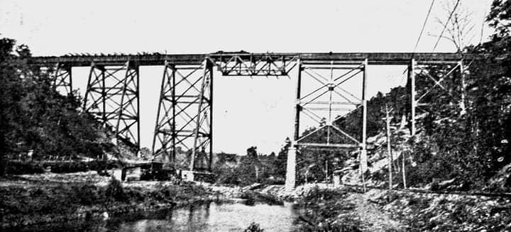
We had a great view of the two large railroad bridges as we approached them ahead.

It's a really cool spot, because the road we were walking was also tracked, below and out to the Safe Harbor Dam. The rails are still visible in that lowest bridge.
The Safe Harbor Dam and power plant was completed in 1931, and dammed the Conejohela Flats to create Lake Clarke.
We continued straight, and there is a trail off to the left that ascends along the edge of the trestles, and reaches the Enola Low Grade Trail, the higher of the two rights of way.

The lower, earlier 1877 Columbia and Port Deposit Railroad, later Pennsylvania Railroad along the Susquehanna River, is still active down below. I understand some of this right of way was moved uphill a bit because of the construction of the Safe Harbor Dam.

The trail was the Atlgen and Susquehanna Branch of the Pennsylvania Railroad completed in 1906 as a mostly freight only bypass to the main line to the north.

The old main went right through Lancaster and other crowded areas. This branch had few grade crossings and limited climbs, which made for fast movement of freight.
The branch was abandoned in 1988 and ripped up in 1990.
For years, when the Enola Low Grade Trail was developed, this bridge was the missing link. When Conrail let the line go, it also awarded dollars to each municipality for surfacing and bridge decking, but the Safe Harbor trestle lies within two municipalities. Those municipalities used those moneys elsewhere, and the bridge remained undecked until 2021.

I figure the bridge was left intentionally untouched because they didn't want to figure out what each municipal investment was, and if they built the trail on both sides, the money would likely come to close the gap anyway.

We walked out onto the bridge for a bit to have a better look at the views. Ev really loved running out there and looking over the sides.

Eventually, we moved on along the trail, past the large sign that read Manor Township.
This was a long and pleasant section to hike. There are high rocks that are along the left side as we headed down along the Susquehanna River. It was a nice day so there were quite a lot of climbers out on these rocks.
The raspberry season was just starting out, and this was probably the first weekend of the year where we had some Japanese Wineberries. The black raspberries had just started coming out, and I'd had some of them previously, but the Enola Low Grade Trail was completely loaded with them along the bright and sunny right side.
I grabbed a whole lot of them and put them in Ev's stroller tray to eat. There ended up being a really good mix of the native black raspberries as well as the Japanese wineberries.
I was rather surprised that Ev didn't really have any interest in these this time. Last year, he was nuts for all berries, and earlier this year, he was crazy about the mulberries, but he just wasn't much interested in the wineberries. He ate a few, but then left the really delicious ones in the tray. I eventually had to eat them because I didn't want them going to waste.

Pretty soon, the rail bed started shifting away from the Susquehanna to head east. Catenaries were all overhead because the power coming from the dam still is utilized by the Northeast Corridor.

The pleasant walk continued out across the Green Hill Road underpass, which would be our return route later, and then under the high bridge of River Hill Road.
We could see how the bridge had been replaced and the earlier pier footings were still in place below.
Along the way, I was handing Ev the giant leaves of Paulownia trees.
These strange trees produce leaves that can be over 3 ft across. Native to Asia, and sometimes called Empress Tree, it is so named for Anna Paulowna, once daughter of the czar of Russia.

We continued to the Colemanville Church Road parking area. The road used to cross the tracks to the the Colemanville Church on the other side.

On the last hike in this series, we had walked up Colemanville Church Road to get to the railroad bed. This time, we'd head down that way and get back to the Conestoga Trail where we left off.
It was a very pleasant walk down the road, to River Road, which was the route of the Conestoga Trail.
We turned right for a bit, and pretty soon, the Conestoga Trail descended to the left on a foot path down to beside the Pequea Creek.
It was getting really hot out by this point, and I was ready to use the first good spot with any depth to cool off in the creek.
Pretty soon, we approached the beautiful Martic Forge Trestle on the same rail bed we had just been walking.
I'd not been across this bridge in years. The first time I did it, I was backpacking on the Conestoga Trail, and I climbed to the top to check it out while Jillane waited below. The second time, I walked across it on part of another trip with her, and it had been re-decked with wood.
Somewhat recently, the bridge was burned by an arsonist, and it was completely without any deck. It took a while, but the deck was fully replaced with concrete.

I called this rather convenient, because the creosote-soaked original ties were required to be removed and replaced anyway.

We didn't bother going up onto it this time. I'll do that as part of another future trip. Just after the bridge, there was a good access down to the creek, and we took a break.
There was a good log right along the creek, so it was a good spot to sit stuff down and take a dip. I brought Ev over with me and put him in the water as well to cool off. He liked walking back and forth on the logs, and we took turns helping him.
It felt so much better to have cooled off in the stream, and pretty soon we were ready to move on.

We got back on the Conestoga Trail and continued walking along the Pequea downstream.

For the most part, I didn't really have trouble getting the stroller through. Kirk and Dave helped me when I needed help getting through.
There were some Day Lilies growing along the side of the trail, which at this point was right below River Road. Most people don't realize you can eat these, and that they actually taste pretty good, so I showed everyone.
We continued on the trail, but it got narrower, and harder to push in the swath next to the road. Dave and Kirk helped me to get the stroller up the slope to the edge of the stream while the rest of the group remained on the trail.

The trail came up to the road at the intersection of River Road and and Rt 324, Martic Forge Road.

When the entire group came up, we continued on the marked trail route, which crossed the Pequea Creek on Martic Forge Road's bridge.
We could barely see the railroad trestle from the road bridge at this point, but I still managed to take a then and now compilation of it.
On the other side, the Conestoga Trail turns to the right briefly on briefly on River Road, but I had some more stuff I wanted to look at for my compilations, and history to point out.
 |
| 1906 |

Martic Forge is of course named for the historic former Martic Forge, which operated in the 1700s, and furnished farming implements as well as supplies for Washington's Continental Army during the American Revolution.


On the left side of the road is the former Kepler Lodge, which started out in the 1730s as the Ironmaster's house for the forge, which had additions put on over the years.

The sandstone quarried locally was used to expand upon the building through 1769.
It is likely that the main additions to the building were added under ownership of Robert Coleman between 1793 and 1805.
The forge was in use until the late 1800s, and in 1924, the ironmaster's home was purchased by Mary Kepler, donated to the YWCA as a Summer retreat, and named Kepler's Lodge in honor of her mother, Mary Mathilda Slaymaker Kepler.
The YWCA continued to operate the property until the 1940s when it was sold to the Lancaster Jewish Community Center, who renamed it Camp Taemoh.
The LJCC operated the camp through the late 1960s, and it then became a private residents. Residents since that time have done a wonderful time restoring the property.
Across the street on River Road was the former site of Martic Forge Hotel and Martic Forge trolley station stop on the Lancaster and York Furnace Street Railway Company, better known as the Pequea Trolley, which operated from 1903 to 1930.

The hotel sadly burned down in 2014, just before I had a chance to hike to it. The site still looked like it had a rather recent fire when we passed through soon after.

From this point south, the trolley hugged the walls of the narrow gorge along the Pequea Creek down to Pequea on the Susquehanna River, and the Conestoga Trail pretty much follows the route.
The old trolley bed is a driveway north across the private land next to the former Kepler Lodge.
I had a few more then and now compilations I tried to get set up while we were paused at this location.
Conestoga Trail follows former Lancaster and York Furnace Street Railway Company, better known as the Pequea Trolley, which operated from 1903 to 1930.


The trolley hugged the walls of the narrow gorge along the Pequea Creek from Martic Forge down to Pequea on the Susquehanna River.

We crossed over to River Road where there were a whole lot of cars parked to get into the gorge on the trail.
We could see the foundations of the old Martic Forge Hotel, and then where the station used to stand for the trolley, which was in the compilations I set up.
The trail went into the woods from here, which at first was not very obviously the trolley bed.
We made our way into the woods, but I didn't realize just how rough shape Nicole was in at this point.
 |
| Columbia Historic Preservation Society, 1906 |

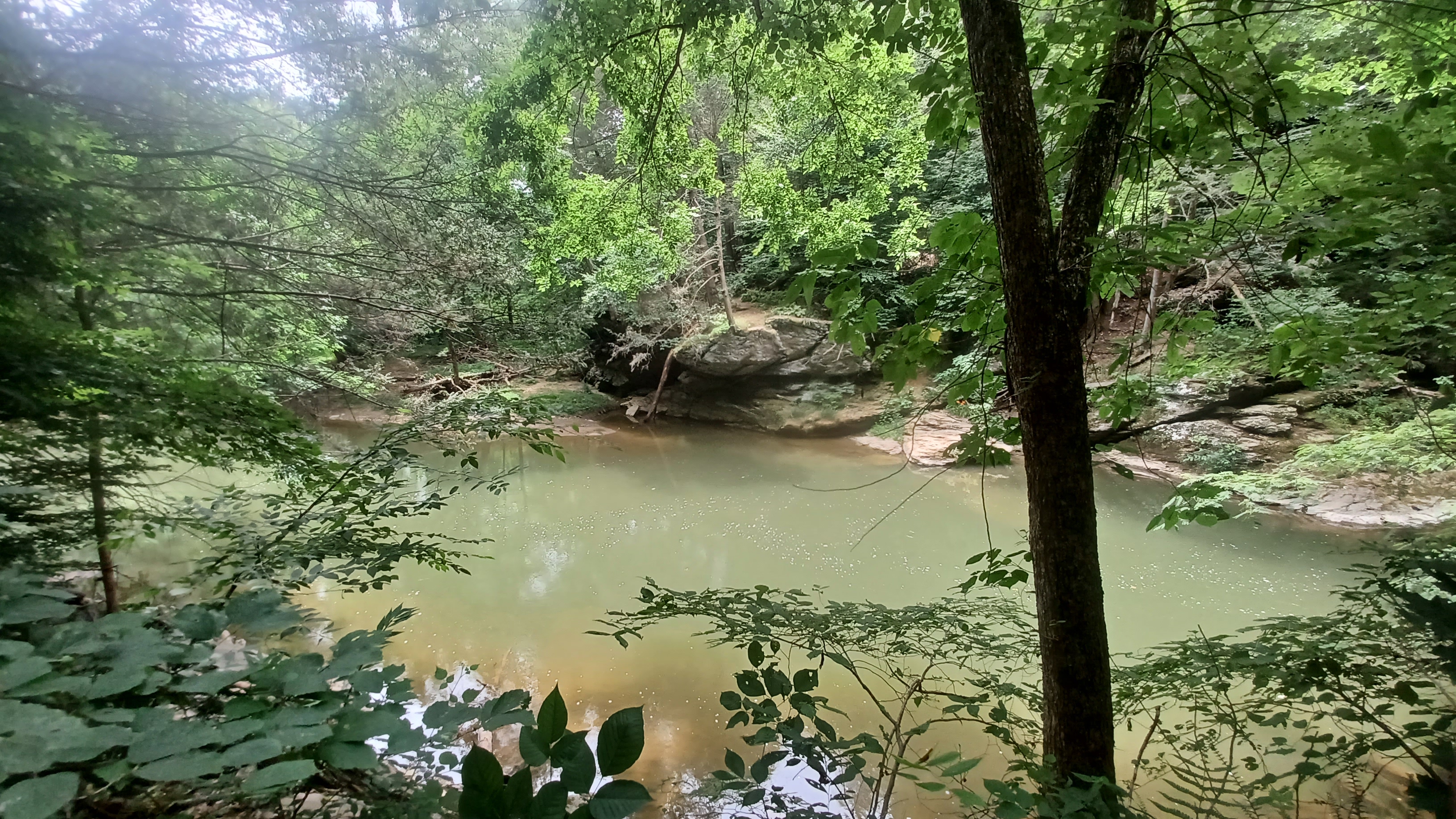
At the spot where we stopped to take a swim, she cut her let pretty badly on something. She managed to just ignore it, and I was glad she wasn't going to cut out and miss the most beautiful part of the hike, but it was worse than we thought it would be.

We continued along the path, and there was a small stream that came in on the left. I understand that the first part of this is the Fox Hollow Nature Preserve.

The trail continues along through this, and then enters State Game Lands 288.
The trail was incredibly pleasant, and after just a little bit, it was no longer very busy. It seems that people just park and go in the water directly from their cars and don't typically go through to see the best an area has to offer.
We made our way downstream for a bit, until it seemed we were well into the public land, because I saw a corner.

There, there was a good trail that went downhill to the right, just upstream from a pool known as Suzi's Hole, which is supposedly named for a girl that had drowned there years ago.

Suzi's Hole is actually a calm pool in the stream, not a rapid pool that is further downhill falsely attributed that name often.
Most of us enjoyed the creek below, because it had gotten so hot, and it was so refreshing. Ev got out and played in the water very well. it was nice and calm, with lots of pebbles where he could run around safely and easily.
Conrad disappeared at this point, we found out later because he had to answer nature's worst call, and there is just nowhere good to go in this area. He ended up having to climb a steep slope.

When we were all cooled off, we climbed back up to continue our walk downstream.

It would have been nice to climb back down to the stream several more times to swim, because so many places looked so welcoming, but I didn't want to take too much time, and it was really rocky.


There was one spot where there had been a trolley bridge over a small tributary, now missing, where we had to go up and down a bit, but overall, this was a pretty easy push for the stroller.

The section was less than a mile and a half, but it was just beautiful.
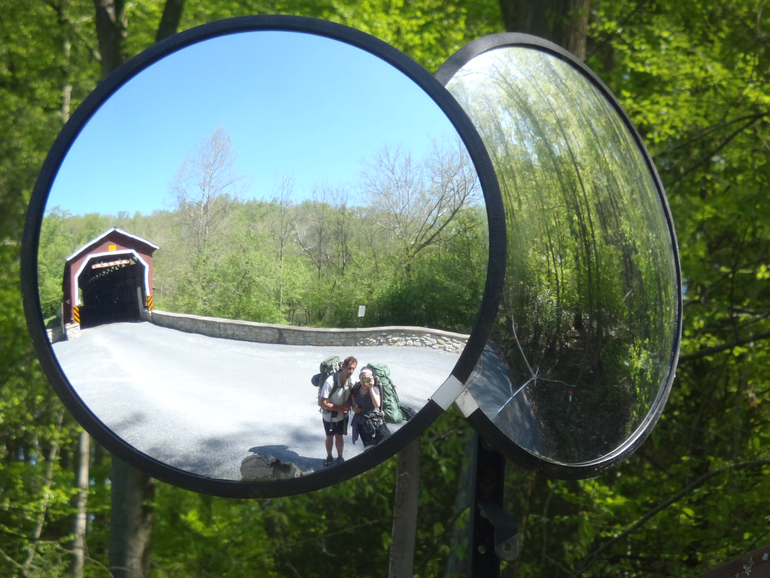
We soon came out to Fox Hollow Road, where the Colemanville Covered Bridge crossed.
Just upstream from this bridge, the original abutment of the 1856 Colemanville Covered Bridge over the Pequea Creek stood.
The bridge was completely rebuilt in 1992 just downstream from the site of the original. It is the second longest single span Burr Arch Truss bridge in Lancaster County at 170 ft.


I first went down directly alongside the original abutment to check out the stone work, which was quite impressive, and there was what might have been an old eel weir in the stream next to it.

We then climbed up, and we walked through the covered bridge and back while the rest of the group was taking a break.
There was a mirror for vehicles going through the thing, which I'd taken a photo of Jillane and I in when we backpacked through here, so I got another one with Ev.
We continued on the trail from here, which followed a lightly used road to the west, called Trolley Road, which continues on the old trolley bed.


Eventually, the road came out into the Pequea Creek Campground.

To the left, there was a camp store. It looked like a good opportunity to go up and take a break, maybe get some food.
They had a little ice cream parlor with home made ice cream, and so we had to indulge here. It was great! Ev and I split a vanilla one, which was quite refreshing.
I let Ev out to run around like crazy again, which worked out well so he'd sit well in the stroller after again.


We descended back to the camp road, and the Conestoga Trail continued through the campground on the now grassy former trolley bed.

The trail continued onto a very pleasant and easy back woods section along the Pequea Creek again after the campground. I remember when hiking this with Jillane, a sign read something like "Conestoga Trail hikers only", which was kind of cool.
The trail turned into the end of the road out of the little settlement of Pequea, on which several people live.
This is a very interesting little community of homes that are built up into the steep slopes of the south side of the Pequea. I remembered it being odd the first time walking it, with several abandoned homes.


This time, I noted particularly that some of the homes I had hiked by abandoned were now completely gone.

Some of the home sites had trailers where homes used to be. Foundations up on the slopes, complete with steps, had nothing on them anymore.
Some of the places were very unique, but well kept, with very nice landscaping.
Some of them I couldn't tell for certain if the buildings were abandoned or occupied.
These were all interesting places because most all of them had access directly to the Pequea, which is navigable right from the Susquehanna.


The stair cases getting to some of these homes must be grandfathered in with permitted. They are some of the steepest stairs I have ever seen going to a residence.

We just continued on the trail/trolley bed past all of these homes until the trees opened up and we were looking directly out to the Susquehanna River again.
The bridge carrying River Hill Road was directly ahead with a boat launch, and the Port Deposit Branch railroad bridge was just beyond that over the same.
We walked to the end of the road, where the Conestoga Trail blazes turned left. It gets too rough to continue on it with the stroller at this point, and so we continued to the right and crossed the Pequea on River Hill Road.
.jpg)
This next leg of the hike was where I didn't know what to expect. River Hill Road continued to the north, but I didn't want to follow it because it was too big with a narrow shoulder.

My plan from here was to stay along the Susquehanna, beside the old Port Deposit Branch.
Google Maps seemed to suggest that Morrison Lane continued right beside the tracks for some distance north, until getting to the site of Shenks Ferry.
If things really didn't work out right, we would walk River Hill Road to abandoned Green Hill Road and hopefully get back on track.
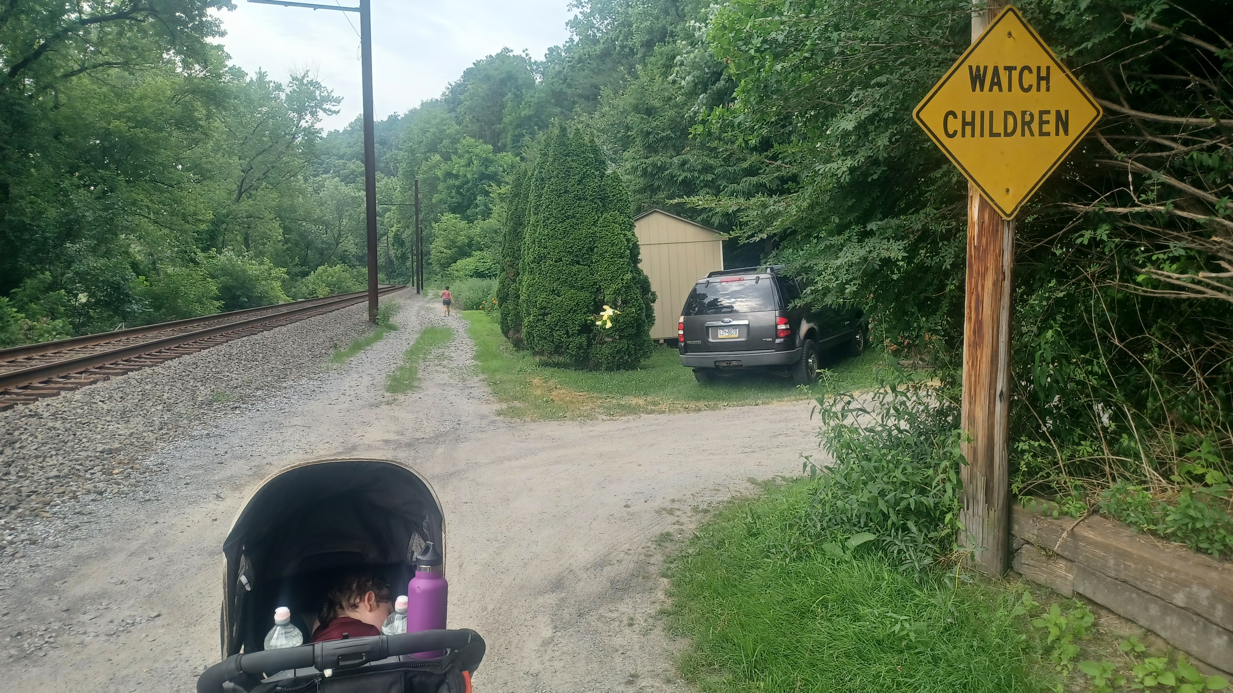
A short bit after passing the boat launch, we reached a driveway sort of road on the left, called Morrison Lane. We turned left and started walking down it, and I was thinking it might be that we'll just have to turn back after walking down there.
The road went to right along the edge of the former Pennsylvania Railroad.
It was odd, and I liked it.
Ev was passing out about this point, and by the time we were along the tracks, something he would be excited about normally, he was fast asleep and not waking up.


We continued past the houses, and then after the last house, the road did not stop.

It was just what looked like a service road along the railroad tracks, on what was certainly once a separate set of tracks, but it was a seemingly public road.
I began questioning whether or not we were allowed to be there after a while, but then I saw a 15 mph speed limit sign, which Dave and I were particularly astounded by in that location.
There was a point when a driveway access went off to the right, apparently to a private house, but the ballast covered path continued along the railroad.


The road was still shown on Google Maps, so we kept with it. But it started to suck pushing the stroller.

I watched below to the right, as there was a bit of a dip that separated us up along the tracks with the hillside to the right. Soon, there was a rather clear path down there.
I decided to have a closer look, and there was a perfect road there! Certainly, it was closed to vehicular traffic, but it was good and clear, and I wanted to be on it!
We made our way down, and the bumps and such of it woke Ev up. I was afraid we'd missed a good portion of this route, and with Nicole still well behind us, it was a good excuse to go back and help her to get to this better route as well.


I came to the point where Grubb Brook flows out and under the road, as well as the railroad tracks, by way of a large cut stone culvert structure.

Beyond this, the road turns hard to the left and ascends toward River Hill Road.
This location is reportedly the former site of the Shenks Ferry Grist Mill, although I saw no evidence of it.
I called out to Nicole, and I had arrived at this location just in time. I went down to the brook and layed in it for a moment, and looked into the culvert that spanned beneath both the road and the tracks at once.


I did not realize it at the time, but Grubb Run, before 1875, was home to a narrow-gauge railroad built by Curtis B. Grubb to connect his iron ore banks to a furnace. Apparently, the trail through the Shenks Ferry Wildflower Preserve follows some of this rather forgotten railroad.


Nicole was happy to come down and be off of the direct sun of the tracks, and we soon continued ahead to the north.

There was a nice bench along this route, and a very nice giant Yellow Poplar tree behind it.
Pretty soon, we came to the gate blocking the old road, and a parking area at Shenk's Ferry. I suspect that the road we were walking might have been an earlier, lower railroad alignment and perhaps part of the narrow gauge line referred to, because of how it is built and where.
Shenks Ferry is an historic site itself. Back in 1775, Captain Joseph Reed, who served in the the Revolutionary War militia, purchased land to establish the ferry across the Susquehanna here.


By 1832, Henry Shenks was operating the ferry, and so this is how it got its name.

When the railroad arrived, the hotel served it, and Shenks Ferry became a station stop. More residences and even a school on River Hill was erected.
Also, when the Enola Low Grade Line was under construction, a dynamite factory was near the location and exploded vaporizing eleven workers.
I did another then and now compilation featuring the historic hotel and some of what Shenks Ferry looked like at the time of that railroad construction.
 |
| Coal dredge operation |
In much later years, there was also a sort of dredging operation where coal silt was removed for processing from the river as well. The major flooding from Hurrican Agnes in 1972 changed the way the river was flowing, which ended that operation.


At this point, Nicole was not doing great. She was a trooper and covered a lot of mileage, but couldn't really go on walking much further. Her, Conrad, and Alyssa all got an Uber out from here.

The rest of us continued uphill on the unpaved Green Hill Road.
We soon approached the lovely stone arch bridge that carried the Enola Low Grade line over the road, which we had walked over a bit earlier.
I always find it interesting that while so many other railroad lines were replacing their stone structures with concrete, Pennsylvania Railroad was still constructing new stone structures after 1900, when concrete was becoming more widely available.
 |
| 1919 John Aston Rineer |

There was apparently a big boss with the PRR that preferred the stone over all else, but we also can't ignore the fact that the PRR did not have as direct access to the concrete other lines had. The Lackawanna, Lehigh Valley, and Central Railroad of New Jersey all went close by these industries, which explains why they and other competitors used it more prolifically.


Just after the arch culvert, a side trail to the left led us directly up to the railroad bed, which wasn't too bad a climb, and we were back on the rail trail where we'd been before heading back.

When we got to the bridge, I parked the stroller and walked with Ev out onto the bridge once again to get some more great views.
I don't recall if I was intending to do so or not, but I ended up getting a few more then and now compilations by going up there as well.
We made our way back to the south side of the bridge, and then carefully made our way back down to the path to the stairs, which lead to the edge of the Conestoga River.
 |
| Library of Congress |


 |
| Library of Congress |

I headed out to get home, and by the time I got to Bethlehem, I got a call from a woman in the kid's family, either his mother or a sister, who hadn't heard from him. They just knew he had used my phone. I still don't know if they ever found him, but I might have been the last person to hear from him.
It was a really interesting day, and overall good. The experiences and the learning are just beyond belief and exceeding expectations consistently.