


The hike came up thanks to new friend Bob Mundy, whom I connected with via Metrotrails and acquiring my Honda Odyssey.
It's interesting how all of these turns of events lead to such major things, and a hike is a major thing when you consider we'll be out for an entire day!
I had my previous car, my Honda Element, destroyed by an uninsured reckless driver last year. I thought I was in real trouble and was getting around without a car for a bit, until my brother lent me one of his.

Mr. Mundy contacted me and told me he worked associated with Cars for Cash and did work for a used car lot that really doesn't deal with individuals, but rather dealerships and such, but that the owner, at his request, agreed to make a special deal for me because he liked my Metrotrails stuff.

I ended up getting a really great deal, and after my uninsured motorist insurance kicked in, I ended up getting back about what I paid for the Element to begin with, and only a couple of grand more for the van.
With the van, which I consulted with all of my friends on, I would be able to carry many more hikers, and so it would be the best thing for the hikes. The safety ratings on the Honda Odyssey are also very good, and I feel good about getting something like that for carrying Ev around with me.


I now understand that a new movie, "Deadpool and Wolverine" had made jokes about the Honda Odyssey and comments like "The Honda Odyssey f*cks hard", and so I suppose I ended up with the hip joke vehicle to have at the right time.

So, Mr. Mundy and I connected through this deal, and he reached out to me one day not too long before this hike to let me know that apparently demolition of the old Fort Monmouth site was imminent, and that I should try to arrange a hike through the site before any more demolition begins.

I had never walked through this area at all, and in fact, prior to this hike and not so long ago, pedestrians were not permitted to walk around the site at all. Even today, much of it remains off limits.

I decided that we should try to see it, and I looked over maps immediately to see if I could arrange a good hike that would cover this and the surrounding area.
Ev had been talking a lot about going on a train ride again, and I figured I could work this out so that we could use the old NY & LB line in order to shuttle for this one, and add another layer of fun to it.
I started piecing together some parks, incorporated a bit of boardwalk, some college, some cemeteries, and I had something that looked like it would really be a diverse trip.


The station there is a very beautiful one built in 1875, and it looks very similar in style to others built around the time on this line, including one in Matawan.

This one was in really very good repair. It was a larger two story structure from the times when these buildings had live-in station agents.
A major junction site, the Raritan and Delaware Bay Railroad was established here by 1860. It later became the New Jersey Southern Railroad, then Central Railroad of New Jersey Southern Division in 1879.
The line traveled from the Raritan Bay at Port Monmouth down to Bay Side, by way of notable towns such as Lakehurst, Atsion, Winslow, and Bridgeton.

Rails are still in place much of the distance from Red Bank to Bridgeton, the northern and western bits are long gone, and some sections like here remain in service.

This was the same line that had been the subject of so many of our hikes for years, and especially lately I have begun revisiting it.
A long time ago, we traced the first segment between Red Bank and Port Monmouth, but I'd never walked it immediately south of there.
I'd also done all through Wharton State Forest years ago, and then after a long hiatus, I did the segments through the rest of the Pine Barrens up through Franklin Parker Preserve and beyond. I'd also traced as best we could between Bay Side and Bridgeton.

Since Ev has been coming out, I knocked out the sections both north and south of Whiting. I have now walked all of it from Lakehurst to Atsion, and closely from Bridgeton to Bay Side. Eventually, I hope to hike the entire Jersey Central Southern Division. We'd parallel another little stretch on this hike.


The New York and Long Branch Railroad, jointly owned by the Pennsylvania Railroad and the CNJ, was completed through here in 1875. This is basically the line that remains active to this day, still serving NJ Transit as far down south as Bay Head.

I got a lot of shots looking at the station from different angles, and eventually we made our way to the far platform to catch the train down to Long Branch.
Ev was out of the stroller walking around with the group, and up to the station platform. I was with him there, and made sure he stayed back a good distance from the tracks and passing trains.
There was one train that passed by in the opposite direction from where we were going, which I was glad of because Ev got to watch another one.

This was a handicap platform, so it was very easy for me to just walk the stroller from it onto the train. They let me keep it out of the way between the cars a bit. Ev sat down in a seat and just really enjoyed the entire ride sitting with Brittany.
 |
In no time, we reached the station in Long Branch. We exited and the others went down the steps at the platform. I thought I spotted something just down the platform from us, behind a large support for the station awnings. I headed over toward it, because that's where the handicap ramp was for the stroller.
Of course, it was Lerch, hiding there to surprise me! He had stayed at his parents house not too far away the night before in order to join us, and the day ended up being even better.
The station stop where we got off was the original terminus of the NY&LB, established in 1875. I had some historic photos of the original station from the site, which no longer exists today.


I'm not sure where the original station used to be, and I neglected to do the research on where it would have been in order to get historic comparison photos unfortunately.

Many replacement stations end up being handsome structures as well, if they were built before the 1920s or so. This one looks more like a White Castle burger place than a station.
We walked from the station out to Third Avenue, and south a little bit to get to I think a Dunkin Donuts where some of the group wanted to use the restroom.
Once we were done at the place, we headed between buildings on a walkway, out to Pavilion Avenue. We walked this road to the east and all the way out to the boardwalk and beautiful views to the Atlantic Ocean.

I wanted to have the most diverse hike we could get out of this, and a start with a walk on the boardwalk promised that it would be off to a very good start.

We walked maybe a block, and it was mostly all new buildings up against the shore, except for one standout structure.
It was one of the very few remaining Ocean Avenue homes from the early 1900s in Long Branch NJ, from its early glory days when the most affluent members of society, including seven US Presidents, summered here. Today, the waterfront is mostly all new development.
This lovely home was reportedly built in 1907.

We continued along the beachfront to the south for a while, until the boardwalk section came to an end.

There, we turned right out to Ocean Avenue where we would turn to the south.
To the right, we could see the iconic original Windmill restaurant of Long Branch, another of the great signature hot dog establishments the Garden State has become known for.
Opened in 1963, in the atypical Windmill building, and specializing in Jersey flat grilled dogs, it remains in business and popular today.

Unfortunately, it was not open this early in the morning or I might've gone over to sample one.

We continued south about six or seven blocks. It was extremely windy on the shoreline, and so we had to bundle up just a bit. Colder than I was anticipating.
We couldn't get very close to the shore in this stretch because it was mostly private communities, some of them gated, along the water in this area, and the beach would be too hard for the stroller at this point.
Soon, we reached a handsome church building on the right side of the road.

St. Michael's Roman Catholic Church sits between Long Branch and Elberon NJ, just a block from the ocean, and on the north shore of Lake Takanassee.

It started out as a mission church in the 1880s and became an independent church in 1892.
The lake was previously known as Green's Pond.
The Green family allowed some of the land to be used for an early life saving station in the mid 1800s. Charles H.Green served as the first station keeper here until 1871.
The Takanassee Beach Club was operated here by the Peters Family from 1932 as a popular summer destination.

The body of water was donated to the city in 1952.

We continued past the church and across the Ocean Avenue bridge over Takanassee Lake, which is the dammed lower end of Whale Pond Brook. We then turned to the right along South Lake Drive along Lake Takanassee. We had some nice waterfront views as well as views of the old church.
At the end of this bit of the lake, we weaved to the right a bit, and then turned to the left beneath the former NY&LB Railroad beneath the Whale Pond Brook bridge. This section of the line was an extension built after the original Long Branch terminus, completed in 1876.
 |
| Mark Moran/Weird NJ collection |

We paused here for a moment to let everyone catch up, then passed through to the other side.

I had some beer that I had gotten called Clown Shoes Muffin Top, a Belgian style imperial IPA. I thought it was quite good, and tasted like something that wasn't quite IPA. I'd drink it again.
Lerch and I walked out onto what was pretty obviously a former road into the body of water, with a missing former bridge site in the middle of it. We could have gotten across if we really wanted to, but with the stroller I was happy to go the easier way to the left. The gravel road trail turned to the left and then the right to skirt the waterfront.

We reached Hoey Avenue and continued straight through the grass of Takanassee Lake Park parallel with Overlook Avenue to the intersection with Woodgate Avenue, which crossed the lake on a bridge.

On the other side, we passed the nice little Long Branch Volunteer Fire Fighter Memorial, and then continued in the grass along the south side of the lake.
We continued through the grass parallel with Overlook Avenue, and then to Van Court Park, at the crossing of Van Court Avenue, and passed one very nice, big tree. We had to turn to the right to get to the north waterfront here, because there were private homes right up to the waterfront on the south side of it. We crossed and continued walking along the edge of Elinore Avenue.

As we walked along this nice stretch of smaller pond, I spotted something out in the middle of the lake. I was surprised that no one else had noticed it.

It was a small stone building ruin on an island out in the water. I knew there must be some sort of interesting story behind this one.
This pond, the westernmost end of the Takanassee Lake, still on the Whale Pond Brook, was known as Ross Pond.
This area was historically the Wooley Farm, bisected by the Whale Pond Brook.
Wealthy entrepreneur P. Sanford Ross purchased the property and dammed it to create Ross Pond in 1897. He built the stone cottage we were viewing that year, which was accessed via a footbridge on the south side.

There was once a mansion belonging to Ross on the south side, but it is long gone and replaced by new development. The Ross family left about 1926.

There was soon a crushed stone path along the edge of the pond, meandering through some sort of little community garden area, and then an interpretive sign about the history of Ross Pond and the estate.
We continued on the north shore through Ross Pond Park and then out to Norwood Avenue. There, we crossed directly, and entered the campus of Monmouth University.
There was an entrance lane almost across from Elinore Ave, and so we followed that a short bit, and then turned to the right on a paved walkway that headed toward the buildings.

I was wondering while we walked though if we would be stopped and told to leave the campus. We didn't see any signs saying any of the grounds were off limits, but we were an odd looking group.

I think one of the things that tends to make us look innocuous is the fact that I'm pushing a stroller.
As we walked on on the path toward the buildings, I looked to our right to see a security vehicle buzzing around the grounds. I thought for certain they would head over our way, but they continued on without stopping.
We passed by the Science Hall and Hesse Field, and turned to the left past the Erlanger Gardens with columns, to a spot where there was a culmination of paths, just behind the Great Hall, the main building.
 |
| Shadow Lawn |

There's an interesting history surrounding this entire campus.

This West Long Branch property was once home to the Shadow Lawn Mansion, which stood where the Great Hall stands today.
The current American Beaux-Arts style, 130 room mansion was built in 1929 for F. W. Woolworth Company President Hubert Templeton Parson and his wife Maysie. It was designed by Horace Thumbauer and his assistant Julian Abele, the first African-American professional architect.
The Mansion sits on the footprint of the earlier 1903 Shadow Lawn Mansion of John A. McCall, president of New York Life Insurance Company. That mansion burned down in 1927.
 |
| Shadow Lawn |

The college started in 1933, with night only classes for high school graduates who could not afford higher education elsewhere during the Great Depression.

The college attained private status in 1956, and became a four year accredited school and moved from the local high school property to the Shadow Lawn Estate, then of Dr Eugene H Lehman, who served as college President for the first year after transfer. Within a decade, Master's Degree programs were offered. Other properties were acquired.
The great hall fell under Municipal ownership in 1939, was used as another school briefly, before being acquired by the college.

University status was granted in 1995.

There was another little garden area to the left of the path known as the Blonder Garden, which I walkd into to have a closer look around. It was really a wonderful little landscape.
The entire area was pretty quiet. I don't recall seeing any students walking around at this time.
We continued on the path to the north, just to the left of the Great Hall, and then diagonally across a long open lawn to the north.
We soon reached a really nice area with pavers and such, and a descending ramp to an underpass beneath Cedar Avenue, Rt 71.
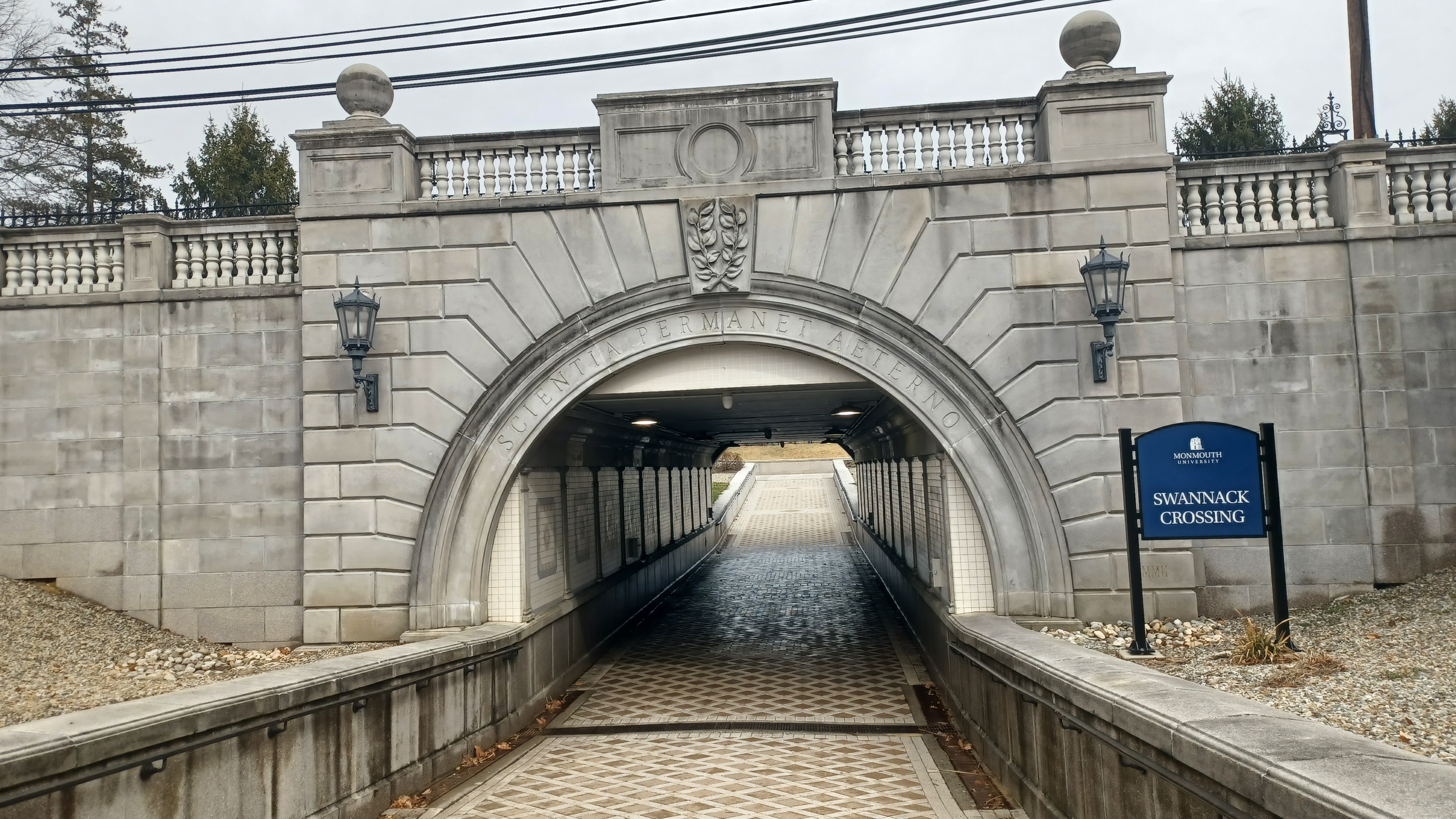
The heavy traffic on the highway warranted the construction of the underpass, built by NJDOT in 2002. It collapsed in 2017, and was repaired promptly. Fortunately no one was injured.

It is today known as Swannack Crossing, and is apparently named for a former manager of the college. From the articles I was looking up, it seems she was in that position at the time of the 2017 collapse.
I thought it was kind of funny that an NJDOT project collapsed in such short order. It seems like the department is kind of an understaffed mess with all of the things going on around the state.
The arch is quite beautiful, and it had some really nice tile decor beneath the road.

There were more buildings to the left and right of us as we emerged from the underpass into more of the campus, which we continued across to the north.

There is one more historic mansion I'm aware of on the campus, which was just a little over to the right, east of where we came out of the underpass.
The Guggenheim Mansion, now the Guggenheim Memorial Library was built in 1905 as a summer residence of Murry and Leonie Guggenheim.
The building was designed in Beaux-Arts style by the firm of M. Carrara and Thomas Hastings, which won them an American Institute of Architects gold medal.

Murry passed in 1939, and Leonie in 1959.

Murry and Leonie Guggenheim Memorial Library was dedicated in 1961. The next-door neighbor property to the Great Hall and Shadow Lawn estate was architecturally as well as geographically perfect for the cause.
We continued through an open, grassy area to the north, and then past the Elmwood Hall and Beechwood Hall. We turned to the left and headed toward the northwest side of the parking area, because I had hoped we would come out to Beechwood Avenue.
.jpg)


Unfortunately, the fence was totally blocking us from going out to the road, so we had to turn back to the east again to find another way off of the campus property.

While heading through the lot, Lerch was on the phone with our old buddy Craig Fredon, and he handed it off to me to chat for a while, which was nice. Craig told me he would be coming back out hiking hopefully soon, so I look forward to seeing him.
We soon came out to Beechwood and turned to the left.
I was somewhat uncertain of what we would be doing for the hike from here. I knew parks I wanted to get into, and I had a plan, but I wasn't totally sure how it was going to pan out.

We headed to the west, and then tuned left a block to get down to Cedar Avenue. I think I was considering going another block north through a college property but it looked too blocked off.

We followed Cedar Avenue to the west, and intersected with Locust Avenue and Monmouth Road. We turned somewhat right and continued north on Monmouth Road from here, and passed through an intersection with Wall Street. There was a strip mall on the other side with a drug store called simply "Steven Drugs", which I thought looked hilarious.
I seem to recall in research after the hike, that this intersection was called Steven or Steven Crossroads or something. Still an odd name, but with an historic background anyway.

From here, we crossed to the north, and there was a small park to the right that would be our next connection, Frank "Clint" Sorrento Park.

We walked down a grassy hill to a parking area and a memorial against a block wall with an epitaph on it.
"Your accomplishments are worth millions, your payment is not.
Please, kind souls, pay a visit, find repose in this spot.
For all your help volunteers, this garden is dedicated to you and the ones you help."
The property was formerly the Giambrone Farm. The namesake Mr Sorrento served Mayor of West Long Branch from 1983 to 1996 and as councilman before that.

We took a little break in the park for a bit, and Ev ran around and played on the playground there while I went over the maps to see how we were going to continue.

The parked had an improved surface walking path around the outside of it, and I wanted to go to the far north side, where we would cut through a swath of woods that was very short, and into the ball fields behind the Betty McElmon Elementary School.
We finally got moving, and made our way clockwise around the park to the north side. There, there was a little path that went into the wood line to a small tributary. It was really muddy, and there were a lot of weeds out there. I think if it were not for the stroller, we could have gotten through, but it was going to be tough that way.

Instead, I had a backup plan. It was only a little bit longer, and would still take less time than the craziness in the weeds.

We continued around the outside of Sorrento Park, and then to the left there was an informal path that came out at the parking behind another little strip mall. Once through, we turned to the left, and then the right, and emerged on Locust Avenue to the east. We turned left there for just a short bit, and then soon again into the ball fields behind the school I had intended to reach.
We skirted the south side of the ball fields for a bit, and then turned right, to the north, toward the school itself. We then made our way around the west side of the school.

There was a chain link fence around the outside of it, and I pushed Ev in the stroller along the edge. It took a little help to lift him up to the grass on the other side, because it was like a tiny foot path. I found out after I had already gone this way that it was quite easy to go through the open fence gate and around to the front of the school without that hardship.

We came out to Parker Road, and the directly across the street from the school was George M. Conway Park. We crossed and entered the park, passed a playground, and then continued to the north on a paved trail.

We skirted a small municipal street and soon reached the edge of Franklin Lake, part of Franklin Lake Park. The trail loops around it in both directions. I chose the right side of it for this time.
The pond here was apparently a farm meadow that would be dammed by farmer Frank Dennis during Winter months for the purpose of ice harvesting in the years before refrigeration.
At some point, it was left watered permanently and now serves as a municipal park with a pleasant loop trail around it connecting to Shore Regional High School.

We walked around the east side of the lake, parallel with Throckmorton Avenue and Locust Avenue, then turned to the west when we reached the north side, parallel with Lakeview Ave.

We passed a pretty pavilion and made our way to the northwest corner of the lake where there was an old mill wheel mounted on a concrete thing, almost growing into a bush.
This wheel was from the Turtle Mill, a gristmill built in 1711 that stood 1,200 ft northwest of this location on the Eatontown-Long Branch Turnpike, present day Broadway.
There was a side path off of the trail after the end of Lakeview Ave, which led out to the entrance road to Shore Regional High School.

We turned left on the road, through the grass heading south briefly, and looked to the right for ways to get up into the Glenwood Cemetery.

Google Maps seemed to show it would be rather easy to access, but in real life, there was another fence in the way that made this a bit tougher.
We managed to get through at one point in the fence. The group helped me get the stroller over the mess, and I carried Ev uphill though some brush to come out in a corner below the cemetery where it looks like the dump off refuse.
We all made our way to the northeast side of the cemetery, and then headed along the roads to the south just a bit until we found a good place to turn off and ascend a hill at the center of the cemetery.


This was an atypical height of land for this part of Monmouth County, which must be part of the Inner Coastal Plain topography at this point.

It was a steep push, but we got to the very top, which provided us with a rather nice 180 degree view of the surrounding area.
We continued along the top of this hill, and looked into a mausoleum which had a stained glass window on the one side. Sadly, someone had broken part of that.
We continued from the top of the hill to the west, down to exit of the cemetery on Monmouth Road, where there was a plaque built into the entrance that read the cemetery was established in 1926.

We turned right on the road heading to the north. It was really narrow just at first, and then we were able to walk along the edge of the Walgreens parking lot to reach Rt 36.

When we got to the highway, there were no crosswalks anywhere! There were sidewalks along the road, but just no good way across!
We needed to get across here. We would just have to simply watch the traffic and got at the time the light turned green from our direction. We managed to get across with no problem.
On the other side, we continued up along Monmouth Road a short distance to the entrance to a large, seemingly empty box store place. There was a Harley Davidson repair place on the far side, and Google says the front part was a Sears appliance repair.

We walked through the lot, and I think it was Justin found some sort of army helicopter tory or something for Ev to have and play with. He ended up with it in the stroller the rest of the hike.

In this lot, there were guys driving around with some sort of really fast go cart. We stopped and watched them briefly. The driver was making some crazy turns. It was kind of surprising they could get away with driving them in such an obvious place.
We continued out ot the tree line on the northeast side of the parking lot, and then turned to the left, northwest. I was betting on there being a path connecting between this building and the Monmouth Park Corporate Center straight ahead.
Fortunately, there was a path. It appeared on the right just near the Harley Davidson place.

We ascended to the next lot and then turned to the right a bit to get around the front of the next building.

The name "Monmouth Park" applied to this refers to the historic equestrian racing facilities of this area established in 1870.
Over a period of around 140 so years, three buildings have carried the name "Monmouth Park".
Financial troubles led to the closure of the first incarnation, and the second time it was reopened in 1882. Horse racing got to be a big deal and brought new faces to the near Jersey Shore community, and a second track opened up in 1890.

Wagering on horses was banned in New Jersey in 1894, and the Monmouth Park facility closed in 1894. It remained closed for 53 years, until 1946.

My understanding is that the original Monmouth Park location was a little west of where we were, closer to Eatontown, and the location was expanded upon and moved to the east a bit, to what we know as Monmouth Park today. I'm not sure at what point it totally moved.
We turned left when we reached the big building front, and then headed north a bit more.
I kind of wanted to walk though Woodbine Cemetery, but it didn't look like there would be a good way across the Turtle Brook, which separated the area we were walking from that, so we continued along through the lot out to an access road to the east, which led out to Eatontown Blvd.

We crossed the road into yet another corporate center lot and turned left, heading northwest.

At the end of the parking area, we cut into the grass, and then up to Crescent Place. A brief right turn on that road led to the parking area for Wolf Hill Recreation Area.
There are mowed trails through the center of this park, and a gravel one that goes around the outside known as Woodbine Way. I didn't want to deal with pushing any harder on the stroller at this point, so we stayed with the easier one and started walking the loop around the outside of the park clockwise.

As we reached the north side, a park ranger drove the trail the opposite direction as us. I was surprised to see anyone patrolling out on this.

We continued ahead, and came to the north side of the loop. When the ranger vehicle was well out of sight, we cut into the weeds a bit and into a clearing on a power line.
I didn't realize it initially while we were walking, but then it hit me that we were reaching an abandoned railroad right of way.
This was the former Central Railroad of New Jersey, and before that New Jersey Southern in Oceanport.

The line passed through Fort Monmouth and connected the Southern Division and the Seashore Branch, then crossed the New York and Long Branch between.

I want to try to hike this line as best I can in the future, but it looks like a lot of it is a fenced right of way with utilities on it. It will probably make a reasonable Winter hike in the future, and it really isn't all that far to go from where it had its junction in East Long Branch to Eatontown.
We continued off of the right of way and into an enormous parking area associated with Monmouth Park.
We walked directly north through the parking area toward the intersection of Oceanport Ave and Port Au Peck Ave. We went across the intersection, turned right, and then followed a trail parallel with Port Au Peck along the south side of Maria Gatta Community Park.

We continued to the east parallel with the road, and the trail was nice because it was sort of set back from the road through this stretch.

We reached the main entrance to the modern Monmouth Park area, which now has a restaurant called the Blu Grotto directly across, and a crosswalk from the trail, but we turned left, to the north.
As we were walking the trail, moving slowly away from the road, I spotted railroad tracks in the weeds to the right that I was not at all expecting to see.
This was a former rail spur from the New York and Long Branch Railroad that served Monmouth Park.

The current NJ Transit line serves Monmouth Park to the east of here, further down Port Au Peck Ave.

There had previously been a switch in this area, but it was hardly visible. It's clearly been growing over for a lot of years, and on the other side of the road, the tracks are all removed, but the right of way is still recognizable.
The modern facility is popular for a lot of reasons other than racing. For me growing up, I remember many friends and family attending Vans Warped Tour, a huge concert that took place here. They've had lots of other events as well, and for many of us, stuff like Warped Tour is what it was known for.

We continued parallel with these tracks through Maria Gatta Community Park, to where the trail turned ninety degrees to the left. We could see the former NY&LB tracks beyond these rails as they approached the defunct junction just before we turned back to the east.

We continued along the north side of the fields, heading west, and Ev started falling asleep.

The trail turned another ninety degrees to close the loop soon, but at that turn, we continued straight onto a dead end street, and then turned to the right onto Riverview Ave. We made our way north on this for just a bit, and then turned left onto Lake Drive.
Where Lake Drive met Main Street in Oceanport, we stopped at the corner at The Sauce Pizzeria for a lunch break.
We went in, and the food looked really good. They had a couple of odd slices that looked like something I'd never had before, so I had to sample one. I think Lerch had the same as me, and we both really liked it.

The guy that was running the place, I think he said with his brother, did it because of a love for it and traveled a considerable distance, about two hours or so every day, in order to run this place.

We hung out and chatted with him for a while there, and it was just a great little stop. I loved that it was everything I love about pizza, but with its own twist that make it quite unique. The place really deserves a visit for those with culinary respect.
We hung out for a while, and Ev woke up before we were ready to go. I'd already eaten the two slices I got with the idea of sharing one with him, and so I went back in to get another for him before we made our way out of there.


We walked Main Street to the west, which came up over a tributary to the Oceanport Creek, one of the large tributaries to the Shrewsbury River.

As soon as we crossed the river, we turned to the right into Old Wharf Park. There was a good walkway directly over along the old waterfront.
It's hard to imagine in now, but there were once steamboats that came this far up apparently. There were historic markers on this, as well as other stuff.
The place was once known as Eatontown Dock or Eatontown Wharf. It was the main center of commerce for the community when nautical access was the most convenient.

There were great views across the waterfront, of large homes and condos and such in the distance.

Ev was tired of his busted toy helicopter we found, and so we left it on a wall in the park. It had paintings on it, and a marble plaque that read R. M. A. 1893. We also passed an epitaph that is the location of the Oceanport Bicentennial time capsule.
At the end of the park we reached Oceanport Avenue, where we turned right and crossed the bridge over the Oceanport Creek.
This brought us directly into the former property of Fort Monmouth, which has been closed since 2011.

The installation was established with the lease of some of the former Monmouth Park racetracks.

The location was ideal due to the already existing Central Railroad of New Jersey spur (Eatontown Branch) and access to existing ports. As such, the site was initially known as Camp Little Silver for its proximity to the port of that name. Soon, it was named Camp Alfred Vail in 1917.
The installation was granted permanent status in 1925 and renamed Fort Monmouth, honoring the Revolutionary War Battle of Monmouth, and because it is located in Monmouth County. The first permanent building was constructed before in 1928.

The site was subject of hysteria when Julius Rosenberg was convicted of passing proximity fuse plans to the Soviet Union in 1942 and 43. The site was formally closed as an army base in September of 2011.

The base had been closed to all but authorized Personnel from September 2001 until 2017 when roads through the former base were reopened.
Some of the buildings from the former Fort are now residences, and others are vacant and growing over with weeds. There are talks of Netflix production taking place at the site, as well as other developments in the future.
Riverside Avenue went to the right, and I kind of wanted to walk all around the property, but I was not sure what the status was and what we could get away with. I decided we would just try to stay for the most part on roads that we could drive with the assumption that it means we can also walk there.

There were several buildings on the left that appeared to be vacant, and then an abandoned bank on the right. Out father to the right, there were more abandoned buildings in view. We passed lots of very large, paved lots which apparently used to once be the locations of more buildings.

Hildreth Avenue went to the left and I noticed a no trespassing sign in the area, but I understand we're allowed to walk through to some degree now. Still, we kept to open areas.

Ahead, there was an enormous building that I then assumed must have been a sort of main building.
Indeed, it was Fort Monmouth's Russel Hall, Monmouth County NJ, compared to the same scene on our 2025 hike.
Completed in 1936, the last pre World War II permanent structure completed at the fort, it served as the headquarters, and included post library, chaplain's office, court-martial room, classrooms, and more.

The building was named for Chief Signal Officer Edgar Russel.

The site closed in 2011 with the rest of the fort, but Google Maps is showing that this building is still being used for some stuff.
We walked up toward the front of the building, and then around to the back to the right. Then, just ahead in view, there was an old helicopter on display. We of course had to go over and look.
Lerch commented that if only we'd waited to leave Ev's broken helicopter behind, this would have been the perfect place to do it!

It had no rotors, and it was locked up, surrounded by concrete barricades so no on could damage it with a vehicle.

It was pretty cool to see, and unexpected. It's always great to see stuff like this while walking.
Just behind this, some of the concrete barricades had painting on it saying "US MAPS", as well as a Jack In The Box, that said "Asylum" and "get crazy" on it. This was the perfect opportunity for our group shot.
We continued along the road behind the place heading to the west, and I figured we might be able to continue along this way for a while, off of the main road though Fort Monmouth. We soon passed a very nice World War II memorial. I recall a few smaller memorials as well during our time passing through.

This made me wonder; if they are to demolish and redevelop much of the Fort Monmouth site, what is to become of all of the memorials there?

Far to our left, I spotted the church from this base, which may still be used because Google maps shows this as the Triumphant Life Church Assembly of God.
Many more disused buildings were on our way, and we passed a chain link fence that had tons of gloves attached to it for some reason. Probably some sort of weird fraternity thing, but I don't know.
We continued on Sherrill Avenue west until it got near Parkers Creek Branch, and then turned to the south.

We passed by what had apparently once been a skating rink or something, then reached Hildreth Avenue, and turned to the right to head east. There was a good sidewalk through this area, as we passed by many abandoned buildings. They had weeds growing on and all around them, and many of them were almost exactly the same style as the previous one.

There were lots of cars that went by us through this stretch, but no one stopped or asked what our business was there, so I guess we were fine.

There were signs specifically facing the north, which said it was state property, no trespassing, with signs for no walking, no bicycles, and no cars.
There were sign holders in front of the buildings, but with no signs in them.
The old New Jersey Southern Railroad branch that I had considered following, and we had crossed earlier, was just a bit south and parallel with this road, but I decided against trying to do it, because I wanted to see more of the buildings on the main road anyway.

We continued walking the stretch to the west, and this main road apparently shifts names to Saltzman Ave, and then Ave of Memories.

Whatever the case, we followed it all the way to the west end of the base and the old entrance.
Despite having been closed for so many years, there are still very nasty fences around the entire place with sharp tops that would discourage most anyone from trying to get over.
This leads out to Main Street, and the gate in the fence was open for people to be able to walk through, but it was too narrow to push the stroller through. Traffic was also pretty nasty, so I had to wait for a good break and push Ev in the stroller around the outside of it in the traffic lane to get through.

We went right across Main Street onto Tinton Avenue and continued west.

My plan for the hike from this point was to walk closely parallel to the former New Jersey Southern/CNJ line. Because I'd walked so much of it before, I wanted to knock out every piece of it I could.
Walking parallel roads can be pretty boring, and so this was a good opportunity to take a bit out of just a little piece of it as part of this hike.
I wasn't sure how we were going to get through. There was an apartment complex parallel with the tracks here. The tracks are not really active, but I didn't want to cause any trouble either.

Uncle Giuseppe's Marketplace, a grocery store, was just north of the end of the apartments, and I figured they would probably have a path through the woods to get to somewhere as
convenient as that, but then again, there was the Parkers Creek Branch in the way between the two.

I turned to the right on the road when we approached the overpass that carries Tinton Road over the tracks. We descended to near them, and then I noticed there was a rather clear path on the west side of the tracks ahead.

The route might have been an old road, or just a utility clearing. It led to a development called Society Hill at Tinton Falls.

Someone went ahead, and they found a trail in the woods to the left of the tracks, so we decided to just cross the tracks and follow that to the north for a bit.
Right in this area was an old metal mile marker that probably dates back to the Jersey Central days, but there was no number, or at least any discernible one left on it.
We followed the very nice path into the woods parallel with the tracks, and there was a little foot bridge over a small tributary out there. I wasn't sure if this was some sort of a municipal park or a private thing.

I found my answer pretty soon. There were a couple of people working out in the edge of the woods behind a house ahead. It seemed there would be no good way to go out to the next road without getting onto someone's private property so we opted to head back to the tracks.

We headed north parallel with them a bit, and reached the creek again where there was no choice but to go up. We then came to a spot where there was an informal path across the tracks, and to the left there was apartments and townhouses. I chose to turn this way to have an easier time.
We walked up into the development and reached Crawford Street where we turned to the right. There was a good sidewalk along the entire way, and we used the walks that took us right up along the front doors of the homes, which was more pleasant than staying right along the road.

The development led us out to Shrewsbury Ave, where we turned to the left.

Some of this way, there were no sidewalks, which made it not as nice to walk.
Before we got to Sycamore Avenue, there were a lot more businesses with parking lots we could walk through, so that was a bit better.
When we reached Sycamore, we turned to the right, descended, and then reached the railroad tracks again.
To the right at this intersection was Lawes Coal Company. I figured this was probably a rail customer on the CNJ at one time, and some of the old timers have since confirmed it.

What was more interesting to me, which I also found out later, was that this was the community of Shrewsbury, and that it was once a station stop.

The Shrewsbury Station used to stand right at the tracks we were going over.
After crossing over the tracks, we turned immediately left on Samara Drive, which took us trough a pleasant, back street development parallel with the tracks to the north, without getting too far away.
The main road parallel with the tracks changed names to Birch Drive, and we continued to Patterson Avenue where we turned left to cross the tracks again.

We turned to the right and paralleled them again on the other side to continue north as we got closer to the middle of Red Bank, on the home stretch.

We reached Newman Springs Road, and in order to continue we had to go left a bit, then to the right on Bridge Ave. We then turned right on Drummond Ave, and were soon parallel with the tracks again. We turned left to head north on Willow Street for a bit.
I don't recall exactly which streets we turned on ot of this point, but at some point we had to end up on Bridge Ave again to continue north. I recall this took us by the Calvary Baptist Church in Red Bank NJ, built in 1928.
 |
| Shrewsbury Station |
We reached Chestnut Street, and then turned to the right, and we soon approached the tracks. Just as we were arriving, a train was coming across, which was of course great for Ev to see.

Once the train was gone, we continued across, then turned left on the other side, back toward the old station building. I got another photo that worked well as another then and now.

Just as we arrived at the parking lot, Chistian Alexander showed up. He lives down there, but I hadn't seen him in quite a while. He hasn't been out on a hike in even longer.
Lerch had been trying to get him to join us with us for at least part of the hike all day, but he'd had some sort of problem with eating way too much food the day before or something, and it led to him not coming out.
Still, I was glad to see him show up at least to this point, and we got done early enough that we could stop and have dinner someplace.

This being more Christian's territory, I left it to him and Lerch to decided on where we would go to eat. Red Bank has quite a great culinary variety to choose from.

I left the van right where it was parked, and everyone was invited to come and eat if they wanted, but not so many were interested this time. Kirk, Tom, Lerch, Chistian, and I headed north to Monmouth Street and turned right. We continued four or so blocks to the east to an Irish pub called Jamian's.
We had a nice spot in a corner area where Ev could be a little louder and crazier, and we had a nice time. I'm pretty sure I ordered whatever was the most interesting burger they had there.

I do miss getting out to dinner after hikes; sometimes I get all "food drunk" after eating combined with a full day of exercise, but this day felt pretty good.

With our drinks, Ev held up his cut of water or whatever he had and said "cheers", happy to be there.

All of these experiences I've had over the years, and how seamlessly he fits into all of it, makes it so much better.


We got finished and headed back along Monmouth toward the station. It had just about gotten dark by then.


Lerch was going to take a train back to his parents I think, and Christian could just walk home.


There's a lot more stuff I can do just out of Red Bank, it's just a matter of getting around to it and making sure it's weather appropriate for the time of year. There's certainly no shortage of new stuff to do.

This one was particularly surprising. We covered so much history on this day, it's hard to believe it was all within about eight or so hours. We'll have to head back again soon.
No comments:
Post a Comment