

Hike #1652: 3/23/25 Del Haven to Pequest Furnace with Scott "Tea Biscuit" Helbing, Amanda Lance Helbing, Dan Lurie, Michael Clark (Lerch), Michele Valerio, Diane Reider, Eric Pace, Jim "Mr. Buckett" Mathews, Robin Deitz, Kirk Rohn, Dan Asnis, Matthew Davis, James DeLotto, Professor John DiFiori, Stephen DiFiori, Galya, Mike Selender, CJ, Tom Vorrius, Eric Lipper, Brittany Weider, Justin Gurbisz, Violet Chen, David Adams, Steve Sanbeg, Brandan Jermyn, ?, Bill Honachefsky, Serious Sean Dougherty, Everen, and Wilhelmina

It was time once again for our big anniversary hike, a March tradition now for 28 years.
This year, it actually fell on my birthday, which was the actual anniversary of Metrotrails hike #1.
This year, I really looked forward to doing this hike a bit more than I usually do.
One of the reasons it appealed to me a bit more was because I added some stuff to it that I'd not done as part of this hike before, and even a little bit that I'd never done as a part of any hike.

With all of the problems around the historic Lackawanna old main line, it was getting harder for me to continue to do the hike as I always had.

This wasn't the first time I'd ever had to change it either.
We used to do this as about twenty miles, with a couple of side trips, but between Portland PA and Washington NJ. That involved crossing the through truss bridge over the Delaware River, which for many is kind of sketchy.
It doesn't bother me in the least bit, and I was happy to do it on the 25 year anniversary hike, but I don't need to do the exact hike the same every year.

We had been omitting the trestle and adding other new stuff to the hike in the past.

Starting about 2017, there was a bad new collapse in the Oxford Tunnel. I have not walked all the way through it since. Even worse, it has silted in much more, where the water is likely to be far over my head. I won't include that on the hike anymore, and it is in danger of collapsing Rt 31 above it.
The Manunka Chunk Tunnel was also always a high point on the hikes, but that washed out Rt 46 two years ago, causing major problems. The tunnels are now plainly visible from Rt 46, and I don't want to have any issues with that.

With all of these issues, I have decided to shake it up a bit more and add some new stuff.

In addition, 2025 is the anniversary of when Warren County was created out of Sussex County. I decided I wanted to do some more Warren County focused events this year.
I decided that what better way to celebrate the county than to visit the county seat, Belvidere!
I added an historic walk through Belvidere to the hike that would add a level of interest we hadn't had before.

The other big thing this year was that it was my first time bringing my son on the anniversary hike.

His mother had been adamant about me not bringing him out on the big party hikes such as March on Musikfest, Holiday NY City, and the anniversary hike. I didn't bring him on the NYC hike last year, and I didn't bring him New Years Day, but I did bring him on the Musikfest one last year.
I decided this time that I was just not going to say anything about it and take him.
It ended up working out great, and I was so glad to have him out with me.

We had done hikes starting at Del Haven before, and continued all the way to Washington for twenty miles, but now, with the stroller, I couldn't do all of that.

Another problem south of Oxford is that the right of way has grown in terribly. Even though much of it is state park below Oxford, no one maintains it and it's really rough to get through.
I came up with a route that would feature the atypical stuff, but still a section of the original hike from Manunka Chunk area to Pequest Furnace, and that would work out well.
I also didn't promote the hike ahead of time all that much. Usually, I post far in advance, but this time I decided I would just put it out there after normal time and see who comes.

We still had a really good showing, and had a really great time.

We got together there, and then shuttled with as few cars as possible west across the Belvidere-Riverton Bridge, into Northampton County, and then down to the little community of Del Haven on the Delaware River to the south.
Our starting point was the same spot we had used in the past, Keifer Field.
I had done two big hikes out of here in the past. One was a memorial hike for my late friend Kyle Zalinsky, and then we did the same hike again, which was arranged as a benefit hike for me when my house burned down in 2010.
The Keifer Field has a playground and such, but is overall a quiet little place. The Lower Mt Bethel Township Trail breaks off at the edge of the playground and heads to the north a bit.

There is a feeling of relief that comes with the actual starting of a hike. Until I actually start walking, maybe because of some sort of past emotional trauma from things going wrong, I get this horrible stress. Once I'm moving, that is all lifted.

I was still worried that Ev's mom would get angry that I took him with me, and try to come pick him up. Fortunately, none of that was a problem.
We walked the hardly discernible path out to Del Haven Road and then turned to the left.
The trail parallel with the road was no longer obvious. We used to use this in the past, but at this point, the crushed stone aggregate that had delineated the pathway was completely overgrown, covered over.
After a bit, the trail crosses the road and passes through a swath of trees immediately parallel, from which point the route was much more obvious.
It felt good to look back to see an enormous entourage of people following me. It felt like "the old days", because group sizes have dwindled, not only since the end of the Jersey Perimeter series, but with pandemic stuff and all that followed it. I don't know what people are using to promote events anymore.

We followed the trail all the way the main road to Riverton, Martins Creek-Belvidere HIghway, and it turned right to parallel that for a while as well. This part was easier to recognize as well.

Soon, the trail turned to the right from this, and then down along segments of boardwalk parallel with cultivated field sections. I always liked this bit of it.
At the end of the field section, the trail turns left and switchbacks downhill to cross over the Oughoughton Creek by way of concrete stepping blocks placed on a concrete pad. It was easy enough for me to portage the stroller over all of that, and Ev likes to get out and walk these things.
One of the best things about this hike was the fact that it was the first time my brother and sister in law brought out their daughter, Wilhelmina, in their stroller. I knew he could handle it, and it felt like more of a family affair. I'd wished my dad, my stepdad, and my other brothers could make it again, but they all had other things going on, and my dad had just been recovering from knee surgery.
We reconvened on the north side of the creek, and watched my brother and his family (including dog) make their way over the crossing.

On the other side, we made our way uphill rather steeply, which felt harder than usual with the stroller this time (maybe I had it overloaded), and then turned left to parallel Depues Road.

We continued straight ahead, and the views of the two steam stacks came into prominent view at the power plant.
The Martin's Creek PP&L was originally called the Roxburg plant for the nearby NJ settlement across the Delaware River in NJ when completed in 1952.
The twin cooling towers at this coal fired plant have for decades led people to believe it was nuclear.
Nuclear reactors are housed in smaller round structures not found at this site.
The plant was coal fired until 2007 when the second coal unit was taken permanently out of service.
The site is now a natural gas burning facility.
We continued on to a utility crossing, and it had these sort of odd yellow traction devices placed over the trail and some of the west areas surrounding it, clearly to keep from damaging the trail as well as environmental concerns for heavy equipment crossing, but it was still rather hard to push a stroller over!

I joked that they knew we were coming, and it was some sort of stroller exclusion device.

We continued ahead and crossed over the Depues Ferry Road. The trail parallels this road heading to the east from there, and at one point goes over a pretty steep spot, but it was fine.
We continued on the trail to the parking area for the Tekening Preserve, in very close proximity to the power plant and took a nice little break.
Once our break was done, we headed into the woods of the Tekening Preserve, which used to be a preserve owned by PP&L, but it was rather recently transferred to the township.

Just before that, they had logged the property, and really wrecked some of the upper trails in the process.
We continued along the trail closest to the Delaware River, which was longer than I'd remembered it being because it was really rough to be doing with the stroller.
I got though the first bit of it and beyond a rock outcropping out there, but then it got to be pretty rough.
Ev walked with some of my friends for a bit, but he was being really lazy this time. Lerch ended up carrying him on his shoulder for a portion of this.

It stayed rough until just about where we got to the wooden observation platform directly above Foul Rift.
There is a lot of history surrounding this spot. Foul Rift is regarded by many as the most dangerous spot on the entire Delaware River because of how dramatically it drops over just a little over a mile.
People wreck and die in boats there more often than many places, and it had been historically a bottleneck for river transportation.

During the American Revolution, a general, ironically by the name of "Hoops", installed several metal rings into the cliffs along Foul Rift for boats to attach to while attempting upstream navigation. Hoops also apparently used a white powder to blast away some of the obstructive rocks in the river.
Some of the rings still exist in the walls below, but no one was climbing down to see it this time.

We noted that Tea Biscuit had his yellow Metrotrails shirt that Jack Lowry had made a few years ago, which features pictures of me, Dan Asnis, and Mr. Buckett, and all three subjects were together, so we had to get a photo of us all.
From here, I could get the stroller through a bit easier. We stayed along the trail beside the river moving ahead.
Google maps is now showing the property as John M. Mauser Nature Education Trail System, but the original preserve name, "Tekening", is apparently a Lenape word meaning "in the woods".
I can't help but wonder if they changed the name of it because of all of the irresponsible logging that had happened back there.
We continued along to the north, and eventually got to the really nice wooden bridge over a spring, and after that the trail was much easier.
Along the way, we passed an old building foundation and well hole. I don't know if I had ever really paid any attention to this before, all of the years of walking it, but this time I wanted to look further into it.

The 1874 A. Pomeroy & Co Atlas of Northampton County shows this location so the home of P. Young.
We continued walking to where the trail system used to have to turn to the left, back out to the main road and parking area.
The first connecting trail that had been put in was along a field edge further up, which then went to the Delaware River Joint Toll Bridge Commission building and restroom, but there is now a new trail that goes directly into the Lower Mt Bethel Township park, and that was what we followed.

The trail went down a gradual ramp following a long abandoned road.
DeLotto had called me at some point in this area, and he was trying to meet up with us.
I told him where to head, and we would catch up with him at the bottom of the hill on this trail to join the group.
We all paused to greet one another when we got to the bottom, and before we were out into the open sun again. I took to a side path briefly to go and stand in the water of the Delaware, which felt great.

There are a couple of ways to exit the Lower Mt Bethel Twp park, and I chose to go basically the main entrance, while if you continue to the right, it comes out somehow behind some businesses further down.
We continued past the ball fields, out to the right, and then to the right across the Belvidere-Riverton Bridge.
It was sad to see the old Riverton Hotel closed down. I'd spent a lot of time up there after play practices and such, and really enjoyed the place.

The bridge was completed in 1904, to replace the previous covered bridges that washed out in the Pumpkin Flood of 1903.
There has been a bridge on this site since 1836.
I stopped the group again on the bridge at some point to go over the history of it, of which there is a whole lot. I told the story of Mr. Murphy, the local garbage man who passed his hat around at the predecessor to the Warren County Farmer's Fair in Belvidere, to take bets that he would bust his head open if he dove from the top of the trusses on the then new bridge into the Delaware

The word is, Mr. Murphy would do this every year, and would reportedly drink away most of the profit he attained!

We continued across the bridge with nice views of the river. I was hoping my friend Scott McDonald would be the bridge guard on this day. He's the former mayor of Washington and he'd certainly have come out and said hello if it was him.
When we got to the NJ side, we first stopped at the liquor store on the right to get some more sustenance. I had hoped Jenny Tull would be able to come on this hike, but her family keeps planning things on Sundays, and at the worst times of all. She used to live in Belvidere for years, and her kids went to school there. But there was no getting out of it.

We turned right and headed up the hill to Skoogy's Deli, crossing the Pequest River on the way.

There's a really nice guy that bought the original Skoogy's, who loves when we bring the group through. He's give me free chocolate milk for promoting his business on the Metrotrails facebook page.
We got sandwiches and such, and had a nice break at the place before moving on.
From this point, it would be where the hike would be entirely different than anything I'd done before.
The old Warren County Courthouse is now 199 years old, having been built the year after Warren County broke away from Sussex County in 1825.

The building has had additions and alterations but retains much of its historic ambiance.

We walked a block to the east, and then turned left up an alley to head out to Mansfield Street. The right turn took us to the court house, and the adjacent community green, Garrett Wall Park.
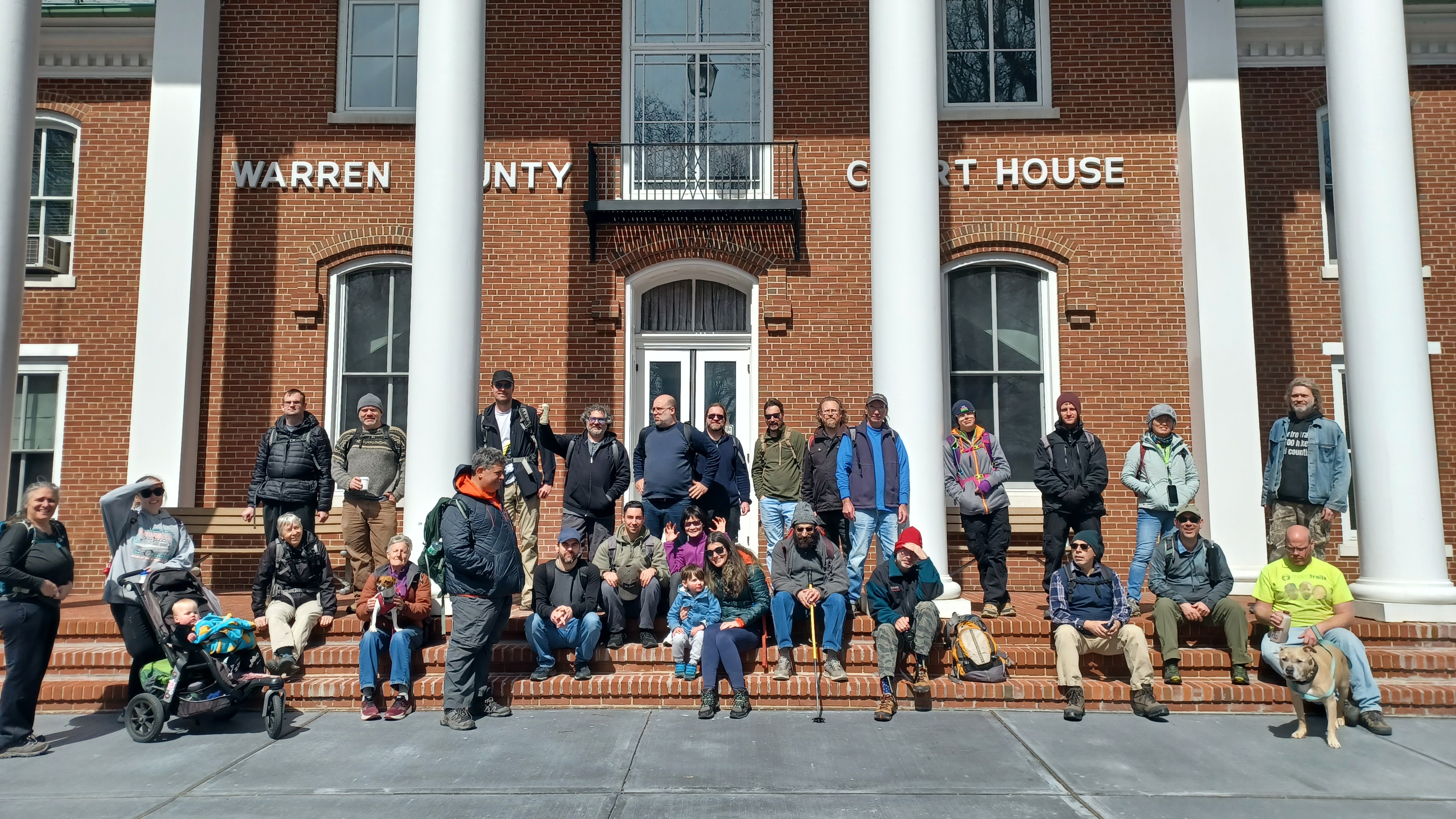
We did our group shot on the steps of the Warren County Courthouse. I'd hoped maybe we'd get someone from the county's executive committee to come out and say hello to everyone on this day, but it didn't happen.
I know people talk about me behind my back, and I'm considered to be this sort of loose cannon or a little bit crazy, and so they don't want to align themselves so much with me. I can understand that. I jus wish people would embrace their crazy a bit more, in positive ways.
Garrett Wall Park is Warren County's oldest public park.

It was established in 1824 by Garrett Wall, US Senator, judge, and attorney, to be maintained as open public space and promenade in perpetuity.

Some years ago, county leadership proposed eliminating the park in favor of more parking and development, but it was learned that this action would be illegal, and the Green was saved. Today, it is home to lots of big, handsome trees, surrounded by beautiful architecture, which includes may Victorian homes as well as the courthouse.
It was Wall who encouraged the use of Belvidere as the county seat. He also donated money for an adjacent church.

Prior to Belvidere, the old Moravian community building in Hope served as the county courthouse briefly.

We walked in a zig zag through Garrett Wall Park, and I pointed out the First Presbyterian Church of Belvidere NJ, built in 1860 to replace the original 1834 structure that burned down in 1859.
We continued south to 4th Street, and turned right to head toward the Delaware River.
We were goofing around, and I never noticed there was a street called "Rear Spring", so more diarrhea jokes ensued.

We continued downhill and soon approached the underpass beneath the former Belvidere Delaware Railroad, which arrived in town in the 1860s, eventually to be extended to a junction with the Lackawanna at Manunka Chunk.

In the past, I would have been walking this line, which is still active somewhat to the Roche facility on the north side of town, but wouldn't be good with the stroller.
Once beneath the tracks, we turned right on Depue Street and continued north.
This is a really pleasant back road, and I think everyone mostly appreciated the route I picked. It was by no means straight, but it was scenic and historic.
When we got to Front Street, we turned to the left into the boat launch parking area for another break, where there is a portable toilet. There was also a giant dead stump of a tree that still stood about fifteen feet tall.
Justin and Lerch immediately climbed up onto the dead tree and I got a photo of them. Brandan commented that this hike "reeked of 2015", and he was right. It was really cool, and I realized that I hadn't gotten a photo of the two of them crazily climbing on anything together probably for a couple of years.

Soon, Brittany, Galya, and Delotto were both climbing onto the branch as well, and then Ev wanted to be helped up there.
Somewhere along these back streets we passed a "children at play" sign, but it looked like they were all disco dancers or something. "Fabulous children at play".
After our break, we turned to the right through grass, and then out to Water Street, which parallels the Pequest Rive heading east. We passed beneath the longer Bel Del Railroad trestle, past a large mural of ducks, and then got back to the downtown area again. We turned left, crossed the Pequest, and continued slightly uphill on Market Street.

On the right, I pointed out the Second Presbyterian Church building, which came about due to a split congregation in the late 1800s, but they merged back together. This one had the steeple removed, kept the stained glass windows, but the building is now apartments.

At the top of the hill, we tuned to the right on Manunka Chunk Road, and then soon left again into Belvidere Community Park where the pool is.

There is a trail off of the rear of that, which I planned to make part of the hike. We walked into the woods, but my brother recognized that we would just be coming right back out, and so more than half of the group waited there with him until the rest of us came out.
I thought it was a nice, pleasant walk on the crushed stone trail through a section of woods. I was in no hurry to get done.
One thing that was not going to work as planned was a visit to Four Sisters Winery. I had planned to do a road walk for part of this with a stop at the winery, but we were going to be closer to twenty miles if we went ahead with that at this time. I instead decided that we would reach the old Lackawanna Railroad bed and simply follow that the way we usually do to near the end.


This was a good choice anyway. I was going to use some of it, but it would have skipped a bit. By doing this, we would at least get a good amount of what had been the traditional hike as part of the route.

We came out of the park and onto the edge of Manunka Chunk Road again, and ascended a bit, parallel with the Hoffmann - Laroche facility. It is a Swiss vitamin C manufacturing company that opened in 1972. Now DSM Nutritional Products.
The Bel Del Railroad still serves the site but has been abandoned to the north of there since the Flood of 1955 caused damages.
As we ascended the grassy edge, we got a good view of Manunka Chunk Mountain.

The native Lenape word is of unclear meaning, however, the town of Mauch Chunk Pennsylvania, not so far to the west of here, means "Bear Mountain" because the adjacent mountain looks like a sleeping bear.
From this view, it seemed that the names might be for similar reasons.
We continued out along the wide, grassy edge of Manunka Chunk Road, to Rt 46. There, the one new guy who's name I can't quite remember, decided to cut out and get a ride home from the Rite Aid across the intersection.

We continued onto Upper Sarepta Road, which I don't think I've ever walked on through before. To the right, there was Skoogy's self storage. Dan found it particularly funny and said it looked like Skoogy owned everything in the area. Indeed, there was a Skoogy Do's pet care, and several years ago, there was a Skoogy's bar on Rt 519 as well.

After the crest of the hill, where we were heading down toward the old Lackawanna Railroad bed, there were some last homes on the left. Just as we passed, Lerch struck up a conversation with a lady in the last house on the left, and he called me back to talk.
I can't remember the lady's name offhand, but she did end up commenting on the stuff I posted about this hike over the next week or so.
It turns out she had already followed Metrotrails, which is getting to be an interesting and common occurrence.

She told us that I believe her husband had grown up in a house that had been part of what is now Beaver Brook Wildlife Management Area ahead, but that the house had been torn down.

She said that they stopped clearing out the creek to manage it for a long while until it turned into the mess that washed out Rt 46 a couple of years ago.
Everyone got really far ahead of us at this point, but it was cool to stop and have a conversation with another local that told us about more of the region's history we didn't know about.
We headed downhill a bit more, and soon reached the former grade crossing of the old Lackawanna main line, the route we had followed on the first group hike.

We turned right to begin following it eastbound. I was surprised to see that much of the group had waited for in this area.

There is an abandoned house near the crossing that is amazingly still standing. I don't know a whole lot about it, but there is conflicting information on it.
The old house has been vacant for some time and reportedly dates back very early. Some have claimed that the home was built as early as 1780.
The house is shown on the 1874 Beers Atlas of Warren County, with strangely no specific owner labeled. It does not seem to appear at that same location on the 1860 map at the same location. Perhaps this place was built for people working at the nearby quarry.

We continued ahead on the right of way, and I pointed out where the siding went off to serve the quarry off of nearby Ledge Road.

Soon, we crossed Sarepta Road at grade and continued through on the pleasant path through property that is considered part of Jenny Jump State Park.
The surrounding state lands are all part of Beaver Brook Wildlife Management Area, but the rail bed itself is state park.
We made our way across Hope Crossing Road, and then to the old Bridgeville Station, which amazingly still stands, but has had additions and such to it. It also suffered a fire, but was resurrected. I didn't think it would last after that one.
We passed alongside the building out to Rt 519, where we usually continue on the right of way or at least closely parallel with it ahead through the sand quarry, then back down the slope to Hot Dog Johnny's.

This time, I decided I would take the road walk between since I had the stroller. I didn't want to push anything too far with that, and the climb down the slope was bad enough even if I managed the ATV paths well.

I was glad to take this way this time, and Eric accompanied me. This time, I had one historic photo taken along the Pequest Rive toward Hot Dog Johnny's I wanted to emulate, but that I never got around to because it was a bit of a walk from a place to park, and I never wanted to bother with it that badly.
This time, the walk would put us right there, and I could have Eric stand with Ev in the stroller while I climbed down to get the shot.

The walk down 519 to 46 wasn't terrible, and even where I was getting the photo, at the narrowest spot, it wasn't all that bad.
What is interesting is that the river has changed its course so much that it required me to be standing well out into the river flow to get the shot, where the historic one was taken toward Johnny's from a previous shore line long since eroded away.
Hot Dog Johnny's is the most well-known of the historic eating establishments on the Route 46 Corridor in Warren County. This stretch of highway is amazing in that it retains so many of its popular eateries that date back to the earliest days of motor touring in America.
The original Hot Dog Johnny's opened in 1944 at the corner of what is now Rts 31 and 46, and shared the space with a gas station. Owner John Kovalsky worked in the Dover iron mines by day, and sold hot dogs at night.
The stand outgrew the original location, and so John and Louise Kovalsky purchased this property along the Pequest River not only as a hot dog stand, but as a place of ambiance, where families could gather.
The original hot dog stand is displayed on the property.
To this day, the business is still family operated and managed by the John and Louise Kovalsky's daughter.

The Metrotrails crew has been stopping by this location on our anniversary hikes for over 25 years!
When we got to the place, our old friend Bill Honachefsky was there, and so I made a video with him about the history of Hot Dog Johnny's, which the business shared over the next few days!
This ended up being my most viral Metrotrails video in quite a while.
Serious Sean met up with us here to finish the hike as well. Bill wasn't going to hike the rest of the way with us, but he was convinced to join by Matt!
Sean brought us some really delicious beers we indulged in, and then after a couple of hot dogs we were off!
We climbed back up to the rail bed, continued out across Green Pond Road, and then along the grade to where it used to cross over Rt 46 on a concrete bridge.
My brother's family cut out earlier, before Hot Dogs Johnny's I think.
The rest of us continued happily across the other side of Rt 46, through Pequest Wildlife Management Area after crossing the three arch Pequest Viaduct over the former Lehigh and Hudson River Railway.
When we got to the curve, where the Lackawanna old main turns right through the deep Pequest Cut, we continued straight on the old Furnace Railroad grade. This took us to a path that descended down to the Lehigh and Hudson River Railway, completed in 1881 and abandoned in 1986. A brief turn to the right here led us over the through girder bridge across the Pequest River and back to our parking along Pequest Furnace Road.
This had been a really fantastic day. I was so glad I had Ev with me and that I got to see so many great friends. Fortunately, I got no grief for it, and Ev had a really fantastic time too.