

Hike #1640: 1/1/25 Uniontown/Phillpsburg/Alpha with Kirk Rohn, Eric Lipper, Mike Selender, Sev, Matt Davis, Adam Davis, Lucas Davis, Violet Chen, Jenny Tull, Justin Gurbisz, Diane Reider, Professor John DiFiore, Teresa I., Linda Heimbach, Samantha ?, ?, Jerry Scanlan, Wayne Scherrer, Randy Piazza Jr, Jessica Lyn, Carolyn Gockel Gordon, Kevin Daubert, Sue Teal-Daubert, and Serious Sean Dougherty
We finished off the new year pretty well I feel, and it was time once again for our New Years First Day Hike.
This year would be something a bit different than we had done in previous years, and I was thankful for it.
I've been doing First Day Hikes every year since before I even worked for the state, and I wasn't going to forego doing it at all.
The state offers its own "first day hikes" which it has been doing since 2012, and I jumped on that bandwagon pretty much right away.

In more recent years, I began hosting hikes on the Warren Highlands Trail, since I pretty much laid out the entire route and did the majority of the clearing work to get it done.
The same hike or a variation of it has been my New Years Day event for years now.
In the months leading up to this hike, there were some things happening that left disappointed with the state, and I decided to scale back my involvement.

I also walked around and fact checked all of the signs in the park, and found them to be horribly incorrect.
Signage issues have been a big problem, and if that hadn't frustrated me enough, being told I was not to be paid for the day was a huge slap in the face. No conversation ever even took place on what exactly I was doing. I got more actual "work" done than anyone that attended.

I felt so betrayed that I swore off all social events for my job, and for the very first time I did not attend the regional holiday party.
Another issue came up with a major liability issue, and I got a written reprimand on it. This was not even legal because it falls under whistleblower issues in the union book.
Finally, in what appears to be a personal snub against me, the next Warren Highlands Trail meeting, which is a multi-agency gathering, was canceled. Emails from the Warren County Director to try to get it rescheduled or at least get the list of key players and their e mail addresses, went unanswered.
 |
| Photo by Mayor Piazza |
When I received the email asking me to host a first day hike, I chose not even to respond to it.
I'm pretty confident that no one at the state is really unhappy that I was not hosting through them. I decided I would have a better hike than we've had in years, focusing on all very interesting and fun stuff.
I talked to my friend Dan Richter at a Toys 4 Tots train event just before Christmas, and helped to sponsor it through Metrotrails. I asked him if we could include a tour of the Phillipsburg Union Tower, an interlocking tower between the Central Railroad of New Jersey and the Delaware, Lackawanna, and Western, as part of our First Day Hike. He was excited to do it.
I also reached out to Mayor Randy Piazza Jr. I've always had positive relationships with the mayors of Phillipsburg. Of course, I served as an assistant to Steve Ellis at my job, and we've become good friends. Harry Wyant before him, I walked the Morris Canal Greenway with when I was on the county's Municipal and Charitable Conservancy Trust. Todd Tersigni I also served on that same board with.
 |
| Photo by Mayor Piazza |
I met Randy's father through Steve, and hiked a bit with him as well. He's been very much involved in Morris Canal Greenway as well.
The current mayor had been following my posts for a while and really seems to enjoy the history in town, so I was very happy to hear he would be coming along as well.
I originally planned to have the hike begin at the Fox Farm Road trailhead on Warren Highlands Trail, but that would have added a big amount to the start. I assumed that since I didn't post it through the state, that I might get far less participants, so the fact that we can only fit two or three cars at the starting point would not be a big deal at all.

This ended up not being the case at all. We ended up having quite a large group!
I chose Alpha as the end point and meeting point, at Alpha Park. I'd not done a hike through there yet either, and figured there were some options depending on what our timing was like.
This ended up being the largest group I'd had in quite a while.
It was also cool that noted Phillipsburg historian Wayne Scherrer was also present to do the hike!

I felt great about how it was going to go. I also got together a huge arsenal of fun drinks that I'd been saving for a couple of months. When I get a four pack, I'd sit one aside for a bit, so when we got to the celebratory hike, we would have a huge tasting of all of the different strong things I'd had recently.
I didn't know quite how it would all play out, but I think it went really great. I had some of the most fun I'd had in a while. The only thing I wish is that I could have had my son Ev with me for the Phillipsburg portion of the trip.
 |
| Photo by Mayor Piazza |
I knew it would be tough to get the stroller through the Marble Hill section of the back woods, but the stuff that was in Phillipsburg would be overall easy.
I'd asked Ev's mom if she would drop him off with me in the early afternoon, but she refused to do it, so I had to do the full trip without him.
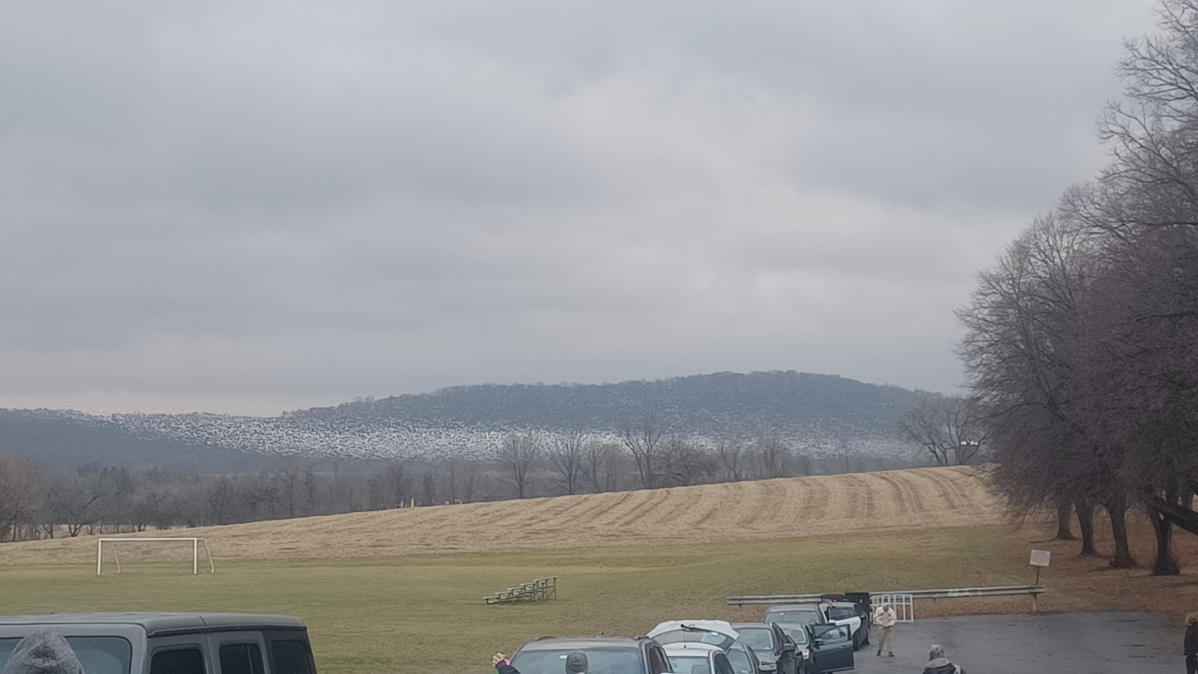
When we met in the morning in Alpha Park, there was an enormous movement of Snow Geese in nearby fields that were just incredible to watch. Maybe this was a sign for the craziness that was to ensue over the course of the next couple of months, with the Bird Flu thing that soon came around.
There were familiar faces and many new faces as well. It was cool to see everyone there.
We shuttled with as few vehicles as possible to our starting point, which ended up being the small lot made of millings on Strykers Road near the Farmer's Fairgrounds.

This portion of the trail passes through Farmers Fair property on an easement. They came to the Warren County Municipal and Charitable Conservancy Trust several years back asking to preserve their unused portion of their land, and the agreement was made if they offered an easement for the trail on the edges of the fields. These connected with the Warren County owned Gieger Tract.
We got everyone together and I gave the normal rundown of what we were going to be doing. I asked Randy if he wanted to be incognito, or if he wanted me to mention that the mayor was with us.
 |
| Photo by Mayor Piazza |
He was good with being known, and that led to even more interesting conversations as we walked through all of the fields ahead.
I had some great conversations with him as well, about the politics that had been so crazy in Phillipsburg, which he seems to be handling with a finesse a bit more than his predecessors. Whether that's because of his attitude, or because maybe he's not seen as extreme on either side, I don't know. I asked him what he thought his administration might be a bit more peaceful than his predecessors, and he told me that when people go after him, he mentions that he'll be at a community event sitting at the dunk tank, and if they have a problem with him, they can take it out on him there.
I thought that was a pretty cool response.
Among the more interesting questions and answers was my friend Sev asking him if it was alright to call Phillipsburg "P-Burg", because someone had told him it was offensive to call it that.

Randy grew up in town, and immediately asserted that it is perfectly fine to refer to the town as P Burg. In fact, he was then captured on video, so that it could be shown, introducing himself as the mayor of "P Burg"!
We continued east along the south side of the fields, past some old carsonite posts that I put in place over a decade ago.
These were posts that were being thrown out at the park, because they were segment pieces cut off of the larger posts that were too long. I would take these segment pieces, put them on the drill press and make holes in them, then bold two pieces together to make one good piece. All of the early field sections of the Warren Highlands Trail I marked this way, just using the junk pieces.
 |
| Photo by Mayor Piazza |
I'm still amazed these posts are still in place so many years later.
We cut through the line of trees at the end of the first field, and then skirted the right side of the second one. This took us to a point where we ended a young woods.
Matt and I with a few other volunteers had made a bridge over a small tributary that flows through this swath of woods, but it has since washed away completely.
We put a stone down in the water of the stream, so that it can be stepped across easily for now.
On the other side, some of the trail is getting a bit overgrown, and people have been going the wrong way to the left, but we let it go for now on this section. I need to get back out there and clear it a bit better.
We continued from here out to the next field and turned right. The trail then skirts the edge of the field again, and soon follows along parallel with Belvidere Road.

We continued on the field edge closest to the road, and stepped over a swale that ushers water into the field from the road edges.
We continued gradually uphill, and I paused everyone to look back in the direction we had come from. There is a view of the Shandor Summit, at the eastern flank of Scotts Mountain. Most don't realize that most of that land is state park land, and it's a nice view, so I wanted to put that out there, and tell the story of how Bob Shandor came to own it.
Shandor announced to his friends that he would one day own the land when he was a young boy, after they run to the peak that I re-named Shandor Summit.
I think it's a really great story of determination.
We made our way to the end of the field, and the wooden post that was to show the turn in the Warren Highlands Trail was removed. Fortunately, there was an old carsonite post nearby that I was able to pick up and hammer back into the ground to show the turn.

We cut back out to Belvidere Road an turned hard to the left for under a half mile.
Soon, we reached the point where Warren Highlands Trail ascends to the right from the road, between two houses. Scott Smith lives in the one to the right, and he keeps the next section of the trail clear and maintained as a volunteer.
We continued between the houses and then up the slope through some woods, past a large tree. The trail then emerged at the field section, where I painted marker posts obnoxiously in bright light blue that the trail is marked in.

One of the neighbors here had removed the property corner, and so the claim was that the trail was passing through private land.
This comes down to another very annoying point, where I was told that in my own personal time I needed to come back out and line stones up through the middle of the field to delineate the boundary, and have the trail go there.
 I am not undoing my work just because someone decided to come in and rip out a property corner. So I never did it, and instead put these two very bright posts in that cannot be missed from a distance. If they think that technically the property line is to not where it is, people can just cut across between those two posts. Othewise, it remains marked as it is and will be so until someone else pushes the matter.
Somewhat recently, we moved the trail from the original descent onto the vacated part of old Kelly Lane, into a wooded swath to the right of it, then back down to that old road. It provided a better route for Scott Smith to get through with his mower and tool trailer.

The old road ascends past a foundation that is supposedly the remnants of the Harmony Township one room school house, as I was told by former farmer Ray Raub before he passed away.
The 1874 Beers Atlas of Warren County shows he school was right where the trail passes between the houses at the bottom, but there is definitely a foundation further up. Which is for sure true, I do not know.
We continued past this, around a corner and where there had been a spring house to the left, and a farmhouse to the right. Another old barn foundation is ahead on the right, and collapsed corn crib. Two modern corn cribs remain there and are in use.

We continued up through the open fields to the top, and then turned to the left a bit more where we reached the highest point in the field. There, I pointed out some of the best views we would have of the day, one hundred eighty degrees through the Lopatcong, Pohatcong, Harmony, and Phillipsburg areas.
I also used this spot as the best opportunity to get our group shot.
From there, we entered the woods and made our way along a side hill segment I built several years ago.

This was another spot where, although it was property assigned to my work, I did all of the labor on my own time. Now, thinking back on all of it, it's a bit more infuriating that there was so little support.
While in this section, I had some really nice discussions with Randy about some back history in Phillipsburg and some of the stuff coming up.
I told him about some of the family history I have around some of the leadership, which he was a bit shocked by (maybe I'll cover that another time), and I asked him some of the tough questions about waehouses.

There is a controversial plan on warehouse development off of South Main Street coming up, which has met a lot of opposition, and I told him I'm not particularly for it myself, because I didn't think that South Main Street could take the burden.
Randy told me that he grew up right off of that, and that there used to be large trucks all the time coming through when he was little, and it didn't really make that much difference, but that more importantly, there was a stipulation that the business be rail served, otherwise it would not pass.

This was a huge deal. The former Bel Del Railroad, operated by a subsidiary of the Black River and Western, is right there. It makes sense to have it serve the site.
Most people are calling for more recreation and tourism along the river, but the problem is here, the railroad is in the way. You can't have people legally traipsing across the active railroad to get down to the river. It's a serious point to make.
I shook his hand and thanked him for being so upfront about it, including his opinion based on having lived there. I still don't think a warehouse is the right choice for the property, but at the end of the day, it is private land and there is only so much one can do, and there are only so many times you can tell a private landowner "no" with what they want to do with their property.

I felt really good about having the opportunity to have these discussions. I wish more often we could have these types of things. All too often, it is politicians having golfing events, which are pretty exclusive, where all of these deals can be discussed. I think we need to get away from politicians slapping the dimple balls and instead, getting them out hiking and discussing, maybe having a couple of drinks in the woods instead of on the "green".
I'm on a lot of e mail threads about all of these developments, and I can't help but feel annoyed at all of the assumption of what different leaders are thinking, and guesses as what they're going to do. It feels like an immature whispering in the corner type of thing. I just want to ask, "why isn't he on this thread" while they're all guessing what might come next. So many of these politicians are very nice, approachable people. Rather than assuming what their thoughts are, why not get it straight from them?

It seems entirely too simple, and it makes too much sense, which is why it probably won't happen.
We continued through woods and regrouped again when we got to the power line crossing, where there was a view over to Forks Township PA.
We continued ahead, and I pointed out that the trail goes by some of my favorite trees, with the interesting root systems and largest sizes.
The trail meandered a bit, and then we came to the most recent reroute when we descended where connecting trail that had been blazed with yellow and a red dot broke off.

Recently, the Director of Land Preservation reached out to me about wanting to move Warren Highlands Trail to the north a bit, in the name of keeping it entirely on county land rather than skirting some of the Board of Education property close by. Washouts had led me to moving the trail further uphill due to washouts over the years, and it seemed a better idea to keep it lower.
I agreed that it might be a good management idea, and Youth Corps were going to see to fixing the reoute.
However, when I got up there, I found a whole lot messed up. The trail was rerouted to the right, onto the older trail, but rathe than use the switchback, they cut directly downhill on a new trail, and then left on the yellow trail, which goes back to the Warren Highlands Trail again to the west.

Rather than mark the trail with the same color light blue that the rest of the trail was marked with, they chose to use a dark blue spray paint, and it looked like absolute shit. Turn blazes were not done correctly, old blazing wasn't fully removed, and it was just a confusing mess. It would ned to be changed.
I reported the issues, but felt we couldn't' leave it as it was for any length of time, plus I didn't know if I could trust them to do it right, because the work was done by a new guy, not the established people I know. I decided I would go back up and do the work myself.

I first went up and did all of the chainsaw work where they took the shortcut and eliminated one switchback. I also did all of the chainsaw work on the entire rest of the trail. Then, I went back with a can of the Warren Highlands paint, and re-marked the entire section correctly.
This was the first time I'd brought a group through since I'd fixed the entire section.
We continued on to the west, uphill a bit, and through the Rhododendron trees, into the area where the old iron mines were. To the right, there was the overlook of the Little Water Gap, also known as Weygadt Gap. I moved everyone ahead a bit more from here.


This was the second of these signs to be wrecked by vandals, the first one being the Little Water Gap sign. That one had been ripped apart and an attempt was made to burn it.
We made our way from here back down to the Warren Highlands Trail where we continued west.
There are great views down to the Delaware River and across into Pennsylvania in this section.
We continued to descend to the bottom, where we were closely parallel with River Road. There, I gave everyone the option of either heading along the river and going through the giant pipe, or staying on the trail and road ahead.

I think Sev and one other stayed on the road route, while the rest of us continued across the road, and then across the former Bel Del Railroad tracks, to descend to the Delaware River.
Below, there is property owned by the Phillipsburg Riverview Association. The path continues along the Delaware River downstream from here.
I brought the group down to the edge of the river, which is really nice, and I pointed out the giant Silver Maple tree that is hollowed out enough that a couple of people could stand inside it at once.

We continued walking the Delaware River downstream, which had somewhat recently been cleared for maintenance access. At the end of the clearing, there was always a pretty good herd path along the slope, but that's been growing in pretty badly. I let everyone know this would be the toughest part of the entire hike, probably.
We moved along this segment, and a large tree had fallen to the right over the original path. We had to go out and around the giant root ball, and soon approached the giant drainage pipe that passes bneath J. T. Baker Chemical.

I first walked through this thing probably back in 2006, and it was so awesome I knew I had to bring groups back through. I've been doing it regularly ever since. I like to say, if I had my choice where I could put the Warren Highlands Trail, it would be through this pipe!
We got in position to help everyone over who would want to go though, and it went pretty well. Everyone climbed over, and we proceeded through the dark pipe. I sang some crooner songs as we went through, because the acoustics are always nice.

After a bit, we emerged at the slope where the pipe goes from being about seven feet high and round to a square where we have to duck down. We climbed all out, and then continued on along River Road back toward Phillipsburg.
One of the things I had considered including on this hike was the future route of the trail up on the slopes above the streets, which is mostly state park land, and includes an old chimney that had been part of the Ingersoll Rand Delaware Park clubhouse facility.

I still haven't brought a large group into this, but there wasn't going to be time this time either. The group at the PU Tower were waiting for us, and I was already running a bit behind. Some things I simply couldn't leave out, like the big pipe, but other things we would have to move along for.
I thought we might actually have extra time to do all of this, plus do both bridges and more, and maybe even Intervase Brewing, but that certainly wasn't happening. I am thinking I am going to need to do another Phillipsburg hike!
The Warren Highlands Trail officially follows the roads from here to the Northampton Street Free Bridge, so we simply followed that for a time. Carolyn parked her car over on the side road ahead where the trail turns toward North Main Street, and joined us for the remainder of the hike.

While walking part of North Main Street, Wayne asked to pause for a moment to go over a bit of obscure history I had not known about.
This part of Phillipsburg, known as the "Historic Flats", was once a black part of town, and home to some ball fields of significance.
What really struck me most was the fact that there had been an African American cemetery in this area, and that it had been paved or developed over. He told us that it was somewhere in the vicinity of where we had just stopped, probably under a paved parking lot. It really goes to show how much disrespect that community was given in the earlier days of Warren County.
We continued walking North Main beneath the Rt 22 bridge, and then continued out to Union Square and the free bridge.
My original plan was that we'd go down along the river and check out the Morris Canal arch, at its western terminus, and then go to the Union Tower, but timing was not working out right for that. Instead, we made our way directly along South Main Street, through town in order to get to the Union Tower, which is located just to the left of the bridge where the road crosses both the former Lackawanna and Jersey Central lines.

We made the left before the bridge and then walked in a side street made of pavers. I started my historic dissertation here by letting eveyone know the difference between pavers and cobblestone, which many don't. I then pointed out where the Lackawanna Railroad freight station had been.
This line was originally built as the Morris and Essex Railroad, a competitor to the Lackawanna that planned to build north through the Delaware Water Gap. When John I. Blair's Warren Railroad got the job done first, the powers that be at Morris and Essex decided instead to extend west to connect with the Central Railroad of New Jersey in Phillipsburg. It was completed here in 1866.

Wayne Scherrer chimed in after that with some shocking history that I had never known about previously.
The area we were standing had a corner to the old pave streets, which was no fluke. This was the site of the first church built in Phillipsburg. I had no clue. Not only that, there was a cemetery, and it is completely unmarked today. We were standing on it.
The entire area of grass was a cemetery, and when the Lackawanna took over and built their freight station out from the bridge overpass at South Main, they went right over graves, and apparently bones were dug up and discarded when that happened. The people doing the work probably didn't even know what had been there, and the railroad at the time didn't care about an unmarked grave yard.

So, the station foundation is probably also more of this old cemetery.
Wayne also went on to tell us more about the site and what happened when the Lackawanna came in.
He told us that the first black landowner in Phillipsburg had lived just on the other side of the bridge, opposite side of South Main Street, in a modest home.
When the railroad came along and wanted that land for the extension of the railroad, he was paid handsomely and was able to purchase an even better house just a little further into town with the money he made from the railroad purchase.

I was so impressed that we did a video of it to put on Metrotrails. This was exactly the kind of history I love finding out about.
We made our way from here down to the PU Tower where a huge crew of volunteers were waiting for us on the bottom level, and Dan was there to greet us and talk about what had been going on management-wise, as well as the history of the tower.
The tower managed operations of rail yard and junction site between the Central Railroad of New Jersey and Delaware, Lackawanna, and Westerns from its completion in 1921 to closure by Conrail in 1983.

The tower sat neglected and vandalized for over twenty years until dedicated volunteers came together to restore it. I remember climbing around by it on our past hikes around 2001 when it was blasted with graffiti.
Ron and Jeane Titus began work on the interlocking tower in the early 2000s, and assembled volunteers including town leaders.
Grant's were awarded including Warren County's Municipal and Charitable Conservancy Trust to help propel the tower to glorious restoration. I was still serving on the county MCCT when the first round of funds for the tower had to be voted on, and I'm proud to say they had my support and I urged my other board members to do so as well. I don't think there was any push back on this one. It made sense to have these complimenting each others work in Phillipsburg, and multiple transportation related projects have been funded close by.

It was a miracle this structure was not demolished like so many others.
This success story is a bright example that where there is a will, there's a way.
The tower group is just one of several organizations working in concert to keep the rich transportation heritage of Phillipsburg alive, and all of the current key players are fixing some of the issues from the past. Dan and his friends are warm and personable, and they seem to be making positive connections.
In the past, it seems that some of the rail and transportation history groups were at odds with one another, for different reasons I'm not fully aware of. Thankfully, now we had folks coordinating with one another, and it is really great to see transportation history celebrated in town.
One other thing that is quite striking about the volunteers at the union tower is the fact that they are so young. It is very encouraging to see a group of dedicated people really into helping, but having so many of them under the age of fifty. My experience has been that the only volunteers were of retirement age, and often well into their eighties!

This group was incredibly knowledgeable, welcoming, and dedicated to a degree that left me feeling very hopeful for the future. That there are still going to be keepers of history, and not just a couple of retired guys doing everything. This would be a huge group of them.
We had a great time hanging out at the tower, and I showed the group the then and now compilations I had done of my son in the front of the tower at the desk during the Toys for Tots event (which was also a huge success, filling up the toy train completely and requiring a second truck).

We all made our way up into the upper level, and we hung out long enough to watch a train come through from the Allentown area heading east.
In the back of my head, I was a little stressed that some of the newcomers of the group didn't care so much for the nerding out on the railroad stuff, for some of our regulars passing around our fun drinks, or even for just the general silliness of the group. I walk a fine line between being very professional and a holder of titles that apparently command a degree of respect, and being a fringe character or and an eccentric. At times, I'll get a little self conscious about how people handle all of that, but I usually am thankful for having the success I've had by being genuine rather than falling in line.

We eventually made our way out of the tower, and walked directly along where a walkway had been up to South Main Street. We crossed, and then followed above the tracks and the Phillipsburg Union Station, which served by the Lackawanna and Jersey Central, which was constructed in 1912-1914.
We continued on to the ramp where the excursion brings people down for the train rides on the former Belvidere Delaware Railroad. This arrived in Phillipsburg about the same time as the Central Railroad of New Jersey, about 1853. There was once a turntable and rather large yard here.
Just beyond the Bel Del line, which later became part of the Pennsylvania Railroad, is the western terminus of the Morris Canal. We walked across the tracks and out to the top of the Morris Canal Arch, which sits at the base of Inclined Plane #11 West.

I explained to everyone how canal boats on the Delaware and Lehigh Canals could cross the river in a ferry style, and be ushered into Inclined Plane 11W, and begin the 102 mile journey east on the Morris Canal to Jersey City.
We made our way back out across the tracks, and then down along the Bel Del for just a bit to reach where the inclined plane used to pass beneath it. We then ascended up to where the power house used to be, as well as the toll collectors house and canal basin.

The giant former canal pond was turned into a dump in the years after the 1924 abandonment of the canal, and then the surface was capped and used for a park after that. There's a skate park over half of it now.
We continued from here on to the east side of the park, and then cut through a fence into the Mt Parnassus Cut, where rails are still in place on what had been a connector between the Lehigh Valley Railroad and the Bel Del via the Kent Yard on the other side. We followed the tracks in just a bit, and then we turned uphill to the right on an incredibly steep path. I wanted to show the group the top of Mt Parnassus.

It's a really awesome spot, but has no real public access. The narrow little path to the top is always a cool trip, which affords views of the entire surrounding area, including Easton, the old canal basin, Delaware River, Kent Yard, Morgan Hill and Lachenour Heights in Pennsylvania, and more.
We made our way down from the front of the giant rock outcrop, and I led everyone down the extremely steep way that I've been using for over twenty years. At one point, you basically have to hang onto a tree branch to make your way down, which is kind of fun. If I didn't know exactly how to step on my way down, I likely would not be doing this at all, but having the confidence from years doing it, I love bringing people down it knowing I can do it safely. When I got to the most sketchy spot, I stayed back and helped everyone down it.

From there, we continued back around to the former canal route, a paved path in Delaware River Park, and worked out way south along the historic route of the canal.
My plan was to stop at the historic Joe's Steak Shop along the way here, but I found out that it was closed for the holiday. Rather than do that, we tried to find something else that would work, and there was really nothing else around that anyone was interested in.
Still, we did make our way out from the park when we got over by the police shooting range, out by the former Lehigh Valley Railroad, and onto South Main Street for a bit. We went by the former school site, the Lovell School. There were two, a front and back building, which I think were used as different grades, and the front was also town hall.

The building served as the Phillipsburg high school from 1890 until 1907.
Today, the Lovell School is gone, but the monument remains, and Shappell Park occupies the former school site on the corner of Sitgreaves Street and South Main Street.
We continued down the street for a bit and made our way beneath the former Lehigh Valley Railroad bridge over the street. There were not a lot of opportunities for food, so we ended up walking down South Main Street until we got to the Paul Mart where we could at least get some snacks.
From here, we backtracked just a little bit to Stockton Street and headed south to Howard Street, and then cut directly into what use to be the Kent rail yard on an ATV path. We turned left when we got to the clear ATV path on one of the rail rights of way and began heading west.

We crossed the former Lehigh Valley Railroad main line along the way, now abandoned.
When Conrail took over both the Jersey Central and the Lehigh Valley, they could abandon one and keep the other in service. However, the Jersey Central had the better bridge over the Delaware, and so the Lehigh Valley is active freight service to Alpha, then the line switches to the Jersey Central at Greens Bridge, and continues on that across the Delaware before switching back to the Lehigh Valley.
There is a grant that is to turn the LV line into a trail through Phillipsburg.
I had considered using part of this right of way for this hike, but it was getting so late at this point I decided against it.
I was feeling super happy by this point, and so I think we ended up on the Bel Del tracks heading to the east a bit more, which has a clear vacant track bed to the left. We then cut over to the left when we got back to where the old Morris Canal comes up alongside of it.
From here, I went over some canal history, and we backtracked a bit to get out along it at the Andover-Morris School, which is now used as the police station. It sits on the site of the former Andover Ironworks, and only a couple of concrete blocks remain of that site today.
Wayne wanted to show us something I have missed so many times over the years, an historic mile marker from the original New Jersey Turnpike in Phillipsburg NJ, chartered in 1806!
He said of course! You're always walking one of the railroad lines, the kent yard, the canal, you never bother walking the street!
The first road to carry the NJ Turnpike name, also known as the Easton - New Brunswick Turnpike, came through what is now South Main Street in Phillipsburg, and then follows roughly today's routes 173, 22, 28, Easton Avenue, and other deviations.
This brownstone marker Wayne showed us denotes 44 miles to New Brunswick.
We walked back the historic route of the canal on the former school yard, and then along the street known as Morris Canal Way. When this was being turned into a street, they were going to call it "Towpath Road", but it actually is the canal, not the towpath, and so it was changed for accuracy.
We crossed over the access road to the railroad tracks, Sawmill Street, and continued on the Morris Canal historic route where I pointed out another substantial site.
The only remaining aqueduct arch that carried the 102 mile canal over a public road is still intact, somewhat buried, jus ahead. Only the top of the arch is visible now. I think Sawmill Street used to go this way, under the canal, before heading out to the river.
A homeless person has been sleeping in what bit of the arch they could get under.
Ahead, the canal joined with the Lopatcong Creek and the two were one for a while. The trail turns left past the sewer plant, and then out along a gravel lane to parallel South Main Street toward Greens Bridge. When Steve Ellis was mayor, he had the section of the greenway done through here with crushed stone. There is also a nice cutout of a canal boat along it, with mule drivers and all.
We continued past the parking area for the greenway, and then continued up to Canalside Pizza where we stopped finally for some food. It was getting pretty dark, and we were glad to have something. Some of the group left us and went ahead at this point to get done sooner.
I think Serious Sean joined us somewhere along the way to the end, but I was too out of it to remember!
I had a couple slices of pizza, as did many of the others, and Wayne came back to meet us with copies of his book "Phorgotten No More", a detailed history of African American heritage in Phillipsburg. He had some really fantastic stories I'd never heard, and so I was excited to have a copy as well.
Wayne sold a few of his books, and I was glad that the hike afforded him some recognition for his work. We all appreciated what he added to this hike. He cut out at this point, and the rest of us continued on.
We traced the old canal route as close as we could under Greens Bridge, where the Jersey Central line had a large stone viaduct, and the former Lehigh Valley has a steel plate girder, which replaced and earlier deck truss bridge.

Morris Canal lock 10 was just under the bridge, and I showed some of the group the remnants of the wooden walkway beneath the bridges.
We continued ahead, and then turned left on Lock Street from South Main. Here, the canal is mostly covered over by the road, but just ahead, the lock house for Lock 9 West is still standing as a private residence beside the buried lock.
We continued ahead along the former canal until Chestnut Street where we turned right. I showed my then and nows along the way so people could see what these spots had looked like.
From there, it was just pleasant back street walking. Lock 8 had just been ahead, but we wouldn't have seen anything.
All of the rest of my plans were not going to be worth doing in the dark, and so we went for the most direct but lesser used streets as possible.
Hunt Ave, Russel Ave, Third Ave, Williams Street, 1st Ave, and then a path down and across former Lehigh Valley Railroad to Lee Ave. then Springtown Road, got us all back to Alpha Park to conclude the hike.
Except for the fact my son was missing from this one, it was really the best New Years Day hike I'd had in quite some time, probably since Hike 1000. We'd had some newcomers, and it left me with some hope that this year would be another really great one despite any adversity in other facets of life.
No comments:
Post a Comment