

Hike #1636: 12/8/24 Ardmore to Paoli with David Adams, Professor John DiFiore, Galya, Kirk Rohn, Justin Gurbisz, Brittany Weider, Diane Reider, Dan Asnis, Violet Chen, Sam Chen, and Everen

This next hike would be a point to point, and part two in my planned "Main Line of Public Works" hike on the former Philadelphia and Columbia Railroad.
My Main Line of Public Works series has been in the works for years, but I had been missing most of the easternmost section of it. One can't really blame me, because it initially sounded like the most boring plan to put together ever.
It wasn't until I started really looking at it closely that I realized it would be quite interesting.

This series was quite out of order, and I didn't really have great intention of doing a full series on it until much later into this sort of "career" I took on.

Of course, there is always interest in the transportation infrastructure, but for a long while, components of this route only came about incidentally, as part of other things I was doing.
It wasn't until I started doing the 911 National Memorial Trail series that it became more serious, because the entire bit through the Juniata Valley of Pennsylvania was a sort of garbage road walk, and I decided to incorporate the old Juniata Division of the Pennsylvania Canal into it to make it more interesting. It was an absolute winning choice.

In addition, the Allegheny Portage Railroad fit into this, as did some of the other trans-Allegheny stuff I'd already done and wanted to do. More of the western division of the Pennsylvania Canal system became part of my backpacking trips. I also did most of the Pennsylvania Canal from Columbia north to Harrisburg, as well as from the outlet of Stony Creek north to Duncannon.
With so many of these pieces filled in, I decided I ought to do the rest of them, which included the Philadelphia and Columbia Railroad.
Originally, when the state was putting together this transportation corridor, which would compete directly with the Erie Canal to the north, it was going to be a canal the entire way through. Of course, this just didn't work with the Allegheny Mountains, and so the portage railroad and ten inclined planes were developed.
The connection between the Schuylkill River and the Susquehanna River had already been achieved by the Union Canal by this time, but it was realized that a rail connection between Philadelphia and Columbia would be a better choice.

Work went fast on this line between the two cities. Unlike the Allegheny Portage, it required only two inclined planes; one from the Schuylkill River up the Belmont Plateau in Philadelphia, and then another down to the Susquehanna in Columbia. The rest of the line could weave around with land contours.

The line went into service in 1834 and was double tracked very quickly for opposing traffic.

The line was secured in place with sleeper stones, because at that time, the use of wooden ties to maintain the gauge was not in common practice. In between the ties was filled with a crushed stone as a towing path, because the earliest transportation on this was by means of horse drawn cars.
The original cars would have been like old west wagons, but the variations that held more passengers came into use over a period of time.
In the earliest days of this line, private companies or individuals could use these tracks and simply pay a toll in a similar way to what was done on the old turnpikes.

Locomotives came into use on the line very quickly. They were even able to get one up the Belmont Plateau on the plane pretty early on. When these got to be more common place, the locomotives took precedent, and private interests had to wait until during hours that the locomotive was not working in order to get on the tracks.

This just wasn't going to work with the growth of this transportation infrastructure, and so it was decided to ban private use of it, and it became mostly locomotive driven services.

The Belmont Plane was eliminated for a better connection to the south, and similarly, the Columbia Plane was rerouted around on a gently grade.
Despite these improvements, there were a host of problems with this Commonwealth owned behemoth of a system. Remember, the system also included hundreds of miles of canals and locks.
The Pennsylvania Railroad was created, and it purchased the majority of the Main Line of Public Works, including the Philadelphia and Columbia Railroad in 1857. It continued to operate the original alignment a bit, except for some out of Philadelphia, which went to the Philadelphia and Reading.

Over time, the line was straightened to eliminate curves, and then switched from double to four tracks.

The culture of the area, to this day, still refers to the locales along the route as "Main Line", and the former Pennsylvania Railroad is still operated regularly for passenger service.
When I decided over a year ago to begin this series, we did so in Philadelphia. The first bit is rather abandoned, and had used an even earlier canal route. It was later dug deeper and became the Reading Railroad's City Branch.
Some of the line later became a trolley route up the Belmont Plane, and my interest in the earlier alignments of the railroad came from all of this heading west.

The local historic pages showed the original line deviated quite a lot from where tracks are today.

The sweeping turn of Bala Avenue from the Bala Cynwyd area was one of these routes. The Reading Railroad had little use for this roundabout thing, and it was abandoned early on, and became a neighborhood.
West, a lot of Montgomery Avenue is also built upon the original grade, and so my previous hike had gone through that way.
It's tough to figure out where it was supposedly went, and I searched lots of websites. Additioally, I procured copies of a Pennsylvania Railroad history book series called "Triumph", which details the Triumph of the Pennsylvania Railroad in its connections between Philadelphia and Pittsburgh.

I got a lot more information reading this, in the days before this hike, and it was just fascinating.

When I found that more of the line deviated from what we had done on the previous hike, I knew I wanted to get out there and do more of it.
That previous hike had ended at the Ardmore Station, but the problem was, we went the wrong way. When we got to the Lower Merion High School, I found out the rail bed leaves Montgomery Ave and goes down Church Road, so I wanted to go right back to where we had lost it.
Also, there was a memorial to the line there, a rather uncommon thing, and I had missed seeing it the previous time because I was powering ahead.
.jpg)
I planned it out that we would be going to Devon Station, and that the route would be about 15 miles with a couple of little side trips and back and forth things we would be doing, but that also didn't work out as planned. It ended up good though.

We met in the morning at Devon Station, and I had carefully checked where we could go to park by studying street view images.

I determined that a point below Lower Merion High School, on Fairhill Road, would be perfect.
We piled into a couple of cars and shuttled to our starting point.
I got Ev's stroller out and got everything packed. I let him walk a bit at the start, because we would be heading uphill a bit, and to the Arnold Field of the Lower Merion High School.
We made our way up and through the gate, and then parallel with the running track area. There was a porta john there which everyone used, and then we followed a paved pathway through the field to the north.

There was a strange four poles that looked like some sort of sacrificial weird thing, so I told Ev to go and lay in it, and he and John went and did so (the first silly photo).

We then came to the gate to the field on Montgomery Ave. I could see the memorial to the railroad across and to the right. The road was busy, but there were crosswalks. We used these and went directly to the very nice display, which was a mounted original sleeper stone and plaque noting that the Philadelphia and Columbia Railraod had passed through here.
Ev stood on it right away.
It was a cool thing to see, and we were soon on our way following Montgomery Avenue only a short distance to the west, to the intersection with Church Road where we turned left to stay on the historic route of the railroad.

The route was pleasant enough, and had good sidewalks most of the way.

The railroad historically deviated from the old alignment to the current four track alignment as we approached the tracks. Today, the road goes over them by way of a bridge.
This was also a junction site early on, and an early reroute point where the tracks connected with an easier grade to Philadelphia.
I peered through openengs on the edges of the bridge for views of the tracks, which at this point is to this day four tracks wide, only with modern concrete ties.

We got across and turned right on Rt 30, Lancaster Ave, which is the historic old Lincoln Highway toward Ardmore.

We made our way down the street and cut through some auto dealership lots, as well as the sidewalks.
Across the street from us on the left was the lovely Saint Colman's Roman Catholic Church, built in 1926 for the congregation founded in 1907 by Reverend James J. Carton.
The church was built to serve the large Irish Catholic community that came to the area soon following the completion of the railroad through the area.

The settlement was originally named Athensville, but was changed to Ardmore, for the Irish town of Ardmore.

The downtown was saved from an eminent domain Improvement project that would have resulted in the destruction of many historic buildings. The township leaders adopted resolution to disavow the use of eminent domain for private interest projects, which prompted the Pennsylvania General Assembly to adopt a similar stance on such private uses in 2006.
Ardmore is a rare case of history winning against private interests. We continued to walk to the west ahead, parallel with the tracks on the main street.

One of the things I really love about doing a hike like this is that I get to experience some of these downtowns I might not have walked through otherwise. The architecture and history offered in these locations is all worth experiencing by foot, if we can just get away from the idea that all hiking must be done through woods or the country.

There were nice bits through the town with murals and such which were nice. We continued on, and passed by where the turn offs were for the current Ardmore Station. We didn't approach it like we did the previous time.

I understand the original Athensville Station was in a slightly different location anyway.
Pretty soon, we made our way to where there is a Wawa right next to the tracks, so we went in and got some snacks and drinks. I got some Double Dutch chocolate milk for Ev and myself.
When we exited the place, and got close to where the Woodside Road goes beneath the tracks. There was a mural with a photo of the original Athensville Station there on the side of the building, which might have been on or close to this location.

We continued through lots parallel with Rt 30 heading west, and we soon came upon what looked to be a very old hitching post for horses. The horse figure head on the top had bolts stuck through it, like it was being used for quite some time to hold onto some sort of parking sign.
We continued from here along the road, crossed to the south side, and then approached the property of Haverford College. This property was a large green, and had the Haverford College Nature Trail running through it. This trail went rather close to where we needed to be, so we got off of the road and began following it west, parallel with 30. It was an easy crushed stone surface at first.

We continued ahead on it, to the intersection of Rt 30 and East Railroad Ave, which angles away from the town area. This road is built on the original alignment of the Philadelphia and Columbia Railroad, and the trail turns to the left to remain parallel with it. I stepped up and got a photo of the former rail bed, and then we continued on the nature trail parallel.
Duck Pond was in view to the west of us, and we continued on the pleasant path around the north side of that and then up closer to the former railroad bed again.
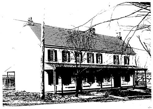
 |
| Lower Merion Historical Society Collection view of old Athensville Station |
When the Pennsylvania Railroad bought the line in 1857, it kept this section in service for a number of years, and even made improvements on it, but it wasn't the permanent plan.

In 1868, the Pennsylvania Railroad straightened the line again, to the north, and the entire section between the west side of Ardmore and Rosemont was abandoned in favor of the new, straighter route.
It was a really pretty area as we approached the road again, with handsome, interesting trees planted around. I pointed out a Metasequoia among the nice trees.
To the right of us, there was an awesome, very large Sycamore tree in a slight incline toward the road/rail bed. Justin and Brittany climbed onto this a bit.


While we were standing at this location, we heard a crash. There were two vehicles, one of them I think a college vehicle, in a fender bender. One rear ended the other.

While we were there, we heard and saw authorities arrive. We watched a bit of the spectacle, and then began moving on down the trail parallel with E Railroad Ave.
The path dipped downhill a bit from here, and the surface was made of a spongy, rubbery material that was pleasant on the feet. Ev got out of the stroller and ran for a bit.
We headed slightly uphill soon, and then crossed Carter Road, which goes into the campus. From there, the trail passed between Carter Road and E Railroad Ave, which was at this point down in a deep cut.

Most people driving this road today don't realize that the cut was originally built for the railroad.

We continued ahead, and soon there was a foot bridge over the road and railroad bed to the right. Of course, I had to go out and across the bridge even if we were to just come right back.
It was a nice spot, and the path continued to the north on the other side. We just had to go to the west further to follow the rail bed.
We continued on down the path to the west for a little bit longer, and then had to descend to the right by way of a pair of steps, to the road.
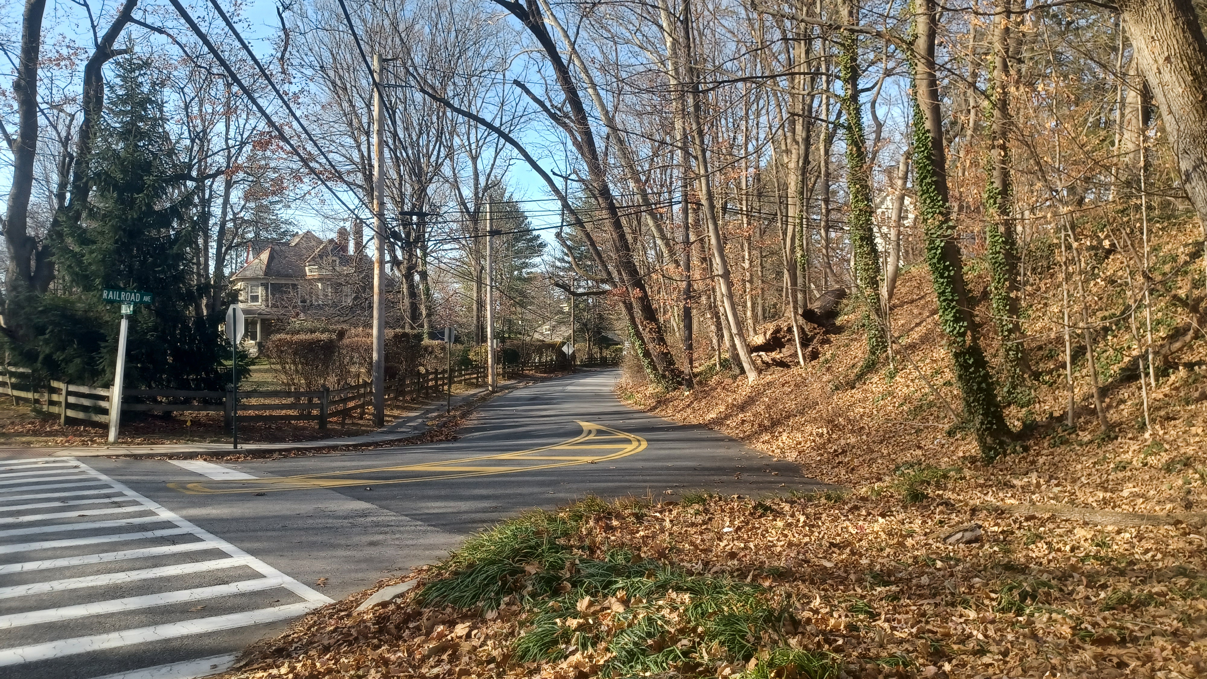
I got help carrying the stroller down the steps, and then turned left, west, on E Railroad Ave, still the former rail bed for just a bit longer. Just ahead, Railroad Ave veers to the right and College Ave continues. We turned to the right to continue.

The section ahead didn't look a whole lot like a rail bed because it wasn't in as substantial a cut as before. It was sort of along a shelf, and then rather level land.

We continued along the sidewalk, and approached the area of Bryn Mawr. We had left Montgomery County, and entered Delaware County.
The suburban neighborhood we were walking through came to a culmination at the intersections of E Railroad Ave, Haverford Road, Bryn Mawr Ave, and Glenbrook Ave.
Just before approaching this intersection, there was an old stone estate gate to the right, which I don't know the history behind, but it could be that of the "White Hall". The name of this little settlement, before the development of Bryn Mawr as a locale to the north, was in fact White Hall.

.jpg)
White Hall was named for the prestigious white hotel that stood on the corner of what is now Bryn Mawr Ave and Haverford Road, and this was the first major stop out of Philly when traveling on the railroad.

When the Pennsylvania Railroad re-aligned, the hotel became a boarding house. Tourism from the city was redirected to Bryn Mawr to the north, and it got its own hotels. The history of the area shifts its attention to there, and not much is really said about White Hall.

The White Hall is gone, but amazingly, the White Hall Station still survives, now a thrift store known as Bryn Mawr Hospital Thrift Shop. Almost as amazing is the fact that not a single historic marker is found in this area to interpret the story of one of the oldest station stops in America, let alone the other former buildings that once graced this formerly very important location.
I got a then and now compilation of the former site of the White Hall that had sat on the corner, as well as of the station building itself from the days it was still in service as a station.
I understand that this station was not the original building, and that apparently it dates to the 1860s rather than the original 1834, unless there is some inaccuracy to what I've read.

I was very impressed that the station building retained so much of its historic character. There was really no mistaking it.
The history at this site is really heavy. One cannot help but consider that Abraham Lincoln's inauguration train passed through this station, and then his funeral train passed through the same spot years later.
I got a pretty good then and now of the station building, and we continued on ahead. The right of way is now Glenbrook Avenue passing through more of the suburbs.

To the left initially is the station stop on the later developed Philadelphia and Western Railroad, another line that to some degree I have followed in the past.

The line opened in 1907 as the Philadelphia and Western Railway, part of an ambitious plan as the eastern link of a new transcontinental railroad.
Original intentions were to continue west to York where it would connect with other contributing lines, but these were canceled, and alternate connection was made to Strafford in 1911, and to Norristown in 1912.
The line operated much like an interurban system, although it also had freight service.

The Strafford Branch was abandoned in 1956 (now Radnor Trail, which we had done before), and all freight service ended on the line in 1970. With this change, the line was disconnected from the national rail network and has operated more like a high-speed trolley line ever since. Folks still refer to it as the P&W today.

The historic line was only closely parallel with us briefly. Glenbook Avenue shifted to the north a bit and merged with County Line Road.
At the intersection with County Line Road, where we went back into Montgomery County, the tracks would have gone rather straight, in line with the direction we had been going coming off of Glenbrook.
We turned left on County Line because there are homes and buildings all built over that original right of way now. We then turned right on Roberts Road, which would have crossed the right of way, but the site wasn't apparent.

We turned left at the end of the road on Rt 30 once again, and continued to the intersection with Montrose Avenue in Rosemont.
Montrose was built on the historic route of the railroad ahead at this point. Just behind us at this point, a church has been built right on the railroad bed.
This was the Church of the Good Shepherd, with the first section of it built in 1894. It had other additions into the twentieth century most notably a cloister section to the west in the 1920s.

The railroad would have passed through where a lower section of the buildings is at the southwest side of the lot.

We continued north on Montrose, and there was the Samurai Japanese Restaurant on the left. This building really looks like a train station with its architectural style, but apparently had nothing to do with the railroad. I'm not sure what the history of it is.
We passed by a large cow statue adorned with Christmas decorations and continued on Montrose up to where it turned to the left to parallel the still active railroad tracks. At this point, the original alignment joins with the later one, just before the approach to the current Rosemont Station.

The A building adjacent to the tracks had a nice mural on it, and most everyone stood there while I went ahead to both take a pee at a more hidden spot, and to get a photo looking west on the alignment.

We started walking Montrose west, downhill slightly and past the current station building.
This station stop was established between 1863 and 1871 after the Pennsylvania Railroad took over, and there's a rather nice older building on the site.
Austin Memorial Park was directly to the left of us, which had some lovely large trees growing in it.
We reached the intersection with Airdale Road, and an old Pennsylvania Railroad built stone culvert still carries the road beneath the tracks.

We went slightly left, and then right on Orchard Way, which parallels the active tracks heading sort of north.

It was a quiet, pleasant neighborhood, not really within sight of the tracks, but as close as we were going to get for a bit.
The road turned hard to the left when ahead there was a dead end at a small school property. We walked west out to County Line Road again, and then headed to the west on it.
Pretty soon, we reached the western end of the Villanova University campus.
The sidewalk made connection uphill to the Pavilion Rear Lot of the university, and so we took this route up to the parking lot and made our way through the pleasant lands of the campus.
The college opened in 1842 after two Augustinian Friars from Saint Augustine's Church Philadelphia purchased the 200 acre Belle Air Estate of Philadelphia merchant John Rudolph.
Early difficulties led to closures, including during the Civil War, when the 1848 Alumni Hall was used as a military hospital. It is the oldest structure on the campus today.

The college reopened in 1865 and has been in continuous use ever since. Substantial expansions have been developed over the years.

Villanova is the oldest Catholic university in Pennsylvania, and one of only Augustinian institutions in America.
We passed by the Finneran Pavilion and the Davis Center for Athletics and Fitness on a main road and came out to Ithan Avenue. We went straight across to the school of business building, and then stopped by The Exchange, which is a sort of school store area for everyone to use the restrooms.
From here, we walked to the north through the campus, up around Driscoll Hall on the sidewalk routes, around some ball courts, and then down to beside the tracks and parallel with a parking garage.

There was an old signal bridge in this area along the tracks. We then entered the parking garage. Ev wanted to get out of the stroller and run around, so I let him do so as we made our way to the rear of the lower level of the building.

There were stairs and such up to the upper levels of the thing, and then a pedestrian bridge across from the parking garage to the next building to the north, and a pathway to the rear of the building and more of the walkways on the campus.

We crossed the bridge and then headed up the stairs in back. Ev was insistent he did not want to go that way, and tried to run the other, until he saw we were leaving him. He hollered and ran across the bridge toward us.

As we ascended a bit, there were statues of a circle of people in discussion, and Ev wanted to get back out of the stroller to look at that as well.
From here, we had to make our way up just a bit more to get to more of a main path through the campus.
My route for this hike wasn't exactly going to be 15 miles, and there was a lot of other stuff along the way that I wanted to check out, so this was one of the areas that I had planned to meander a bit, which would add on the mileage.

There was some sort of construction going on in the campus through this area, in what had been a large field green area, so we had to circumnavigate that a bit, and made our way around the Corr Hall and chapel.

I had looked over the maps for the different points of interest that we might stop by on campus, and one of them was something that simply read "The Orea", at the south side of a field known as the Riley Eclipse.
As we approached the site, we came upon a large abstract, black and white statue, which looked to be an odd, three dimensional sort of yin and yang.
Actually, the sculpture is called "The Awakening", a representation of the facets of education by artist Jay Dugan (1919-1990), donated to the college in 1985.

The way the black and white components of it are situated, it sort of looks like an odd Orea cookie.

Thanks to Dan Asnis, I had a bag of Oreo cookies for Ev, and it seemed only appropriate to enjoy the cookies at the statue!
A large promenade between Sullivan Center, Vasey Hall, Sullivan Hall, and Sheehan Hall continued east from the Oreo. We followed this down some steps, and then turned hard right between buildings to the south.
The next point of interest was something I'd seen on Google Maps reading "Sheehan Beach". I figured it would be another art installation that would somehow include sand.

I was very happy when we approached the site noted on the maps, and it was an enormous BEECH tree!
.jpg)
I was rather disappointed that not only was it spelled so terribly wrong on the maps, all of the people checking in and tagging at the location continued to misspell the thing!
One would think in a place of higher education, that such a grievous misspelling of a tree would not go unchecked. As I write this journal, I went on Google Maps and attempted to fix the misspelling.
It was really an impressive tree. I also uploaded my photo of Ev at the tree into Google Maps. We'll see if it shows up there.

Another giant tree was to the east of the Beech, which Galya got up in. I think it might have been a Cottonwood based on the bark, but I'm not sure.

We were heading east and came out at the corner of Ithan Avenue and Route 30. We turned right and crossed 30 on the crosswalk, past large college buildings that had only rather recently been completed. They were built in an area that had previously been parking, and Dave said something about how the area had been a problem one for some time prior to that during sporting events or something.
We continued south on Ithan Ave, past the stadium station stop and beneath the railroad tracks of the former Philadelphia and Western line. Just a little past that, we crossed Ithan Avenue to the west side and got on a pathway that passed through a green swath of land toward a very long pedestrian bridge that crosses the tracks and campus.

Just before climbing to the bridge over the station, several of us made use of the first woods in a while to relieve ourselves before getting back onto the campus.

Soon, we got on the bridge, and I let Ev out of the stroller to run the path and across. He loves bridges, and even when he's tired, he'll get out to cross those specifically.
This was great timing, because a train was passing beneath the bridge heading east, so we watched it go by.
We continued across the bridge to the north, and there was a beautiful church building straight ahead of us at the end of it.

This was the St. Thomas of Villanova Church completed in 1887. A group of people were congregated just below the last spans of the bridge suspiciously looking toward the church.
Ev was being rather loud and running in anything but a straight line going across. The group of people were quietly asking stuff like "did he do it?".
It was soon obvious to us that we had walked upon an engagement celebration. We ended up walking out to the church building among the family of the happy couple, and the young lady was very surprised to see her family members there.
We got across the bridge, and Ev continued to run around a bit. There was a grassy slope to the right, and he wanted to go that way, but we needed to go to the left, down a paver pathway heading west.

We followed this pathway downhill past the Simpson Hall and O'Dwyer Hall, then to Spring Mill Road. We then continued across it and along Rt 30 heading west.

There was a sort of strip mall to the right called Villanova Center, and we should have walked into it. It seems there is a service lane parallel with the former Philadelphia and Western tracks that would have taken us north under Rt 476 and to the Radnor Station on the line, but I didn't realize it at the time.
We continued on Rt 30 ahead, and passed beneath Rt 476 on that.
We continued on the other side to the intersection with King of Prussia Road. We crossed the intersection and then turned right along the paved pathway parallel with King of Prussia Road.
 |
| Original Wayne Station |
We followd this to the north. There was grassy land to the left of us that we could have used, but I didn't bother with it. At this point, I was just happy to be walking on a dedicated walkway.

We crossed the entrance to Radnor High School, and the paved pathway kept following the road.
There was only a short bit on the left side of the road where the paved pathway stopped. We hurried through that narrower section, and approached the stone underpass beneath the former Pennsylvania Railroad again, with Radnore Station to the right of us.
Dave pointed out while we walked this section of the road as we went by a building he used to work in, which used to be used by the FBI or something like that.

We turned left on a sidewalk that skirted the north side of a commercial center along the parking lot, and then cut into the east side of the rear parking lot of the Opus Virtual Offices.

A guy went by in a car as we walked behind this, which we figured might be a security guard, but then second guessed it based on the way he was driving.
This lot brought us right beside the active tracks for a bit, but then we had to cut to the left at the end, and head out to Rt 30 yet again.
I wanted any excuse I could get to be off of the main road, so I kept trying to get into some of the apartment parking lots and such.
 |
| An early Wayne Station, moved to Strafford |
The building at Wayne 427 had a nice pathway around part of it, but the problem was that there was no way through some of these things.
My friend Conrad used to live in Wayne, and it's a pretty upscale area, but I'd never actually walked it before.
Brittany wanted to stop for lunch, and she found a pizza place that was just ahead, so we pushed to get to that.
I brought everyone up into the back of a parking lot trying to get around stuff, but it ended up being a pointless sort of crummy way, and we had to come right back down to 30.
When a side road called Iron Works Way was parallel with the main road, I again tried to get up there, but ended up in another back parking lot. This time though, I was able to get up and around a fenced area to get behind a Land Rover dealership, and then out to the strip mall with the pizza place.

We had good seating outside, but it was not the kind of pizza we were expecting. Anthony's Coal Fired Pizza is actually a chain, and they don't sell by the slice. We had to wait a while to get food, because it was more of a sit down, fancier pizza restaurant.
I really wasn't that hungry, and if it were something that had a slice or two, I would have ordered, but I just waited for everyone else to eat at this point.
Actually, most of the group didn't eat. Brittany felt bad that she didn't want to make everyone eat if they didn't feel like it.

I probably should have asserted that we go more to downtown Wayne, where I'd had many annual dinners with Conrad and his other friends and family. I think it was Paola's Pizza. That would have been excellent. But it was okay. Dan ordered a pizza and didn't want all of it, so he gave me a couple of slices.
Ev fell asleep, and he was out for most of this break, which I suppose was just fine.
We had already passed the St. David's Station a little before, and the next station was Wayne. The original station was a wooden structure that reportedly had lasted until the 1950s in another use.

I don't know exactly where that original station had stood.
I decided we would make our way to the north on Aberdeen Avenue east of us, and then turn to the left to parallel the active tracks on Pennsylvania Avenue. I assumed that maybe Pennsylvania Avenue might have been an earlier alignment of the railroad prior to 1868.
After we got under the railroad culvert, my suspicion might have been correct, because I spotted with might have been an old sleeper stone in the bank immediately to the right of the north side of the underpass.
 |
| 1930s |

We turned to the left and continued along the road, which was a pleasant walk here.

Along this route, we passed by the former Burket Brothers Coal and Oil Company's coaling trestle remnant on the left.
A siding came off #4 track and was elevated over Pennsylvania Avenue to the north, but all that remains is the concrete infrastructure closest to the present day tracks now.
We continued along the road to the intersection with North Wayne Avenue, at Wayne Station.
We turned left and passed beneath the tracks, and there was a round concrete structure on the north side of the tracks.


I usually know these to be old railroad phone booths, even if they are larger, but this abnormally large one I have been told was a "telephone termination" structure. I'm not sure if that's a thing, and if it is, I don't know what it means.

On the other side, we could see the nice, current Wayne Station, built in Victorian style in 1882-84, just after the raising of the grades through here.
It has been said that an earlier Wayne station was moved some 14 miles to this location from Philadelphia, where it was built likely about 1873, and remained until the Centennial Exhibition in 1876. It was said to have been used as a place for people to purchase catalogs at the exhibition and was known as the catalog building.
The myth circulates all over, but is likely to be false.

Station architects Joseph M. Wilson and Frederick G. Thorn had a substantial influence on the buildings of the Centennial. The "Stick" style of architecture that they applied to the station (actually copying European styles of two decades earlier) became the preeminent style of architecture at the Exposition, so it was, in a way, a preview of the Centennial three years before it opened.
After a time in Wayne, it was moved to Strafford where it still stands today.
I regret that on this trip, we didn't do the side trip to the Strafford station to really see this building in its full glory.

I think we took West Avenue from here, to the west and away from the busy part of town, all the way to Eagle Road.
We turned left here, and there were no sidewalks for a bit. It was a bit odd compared to where we'd been, and there were those types of things most everywhere.
Before reaching the end of Eagle Road, we turned right through the Eagle Village Shops and meandered through more pleasant surroundings for a bit, and eventually back out to Rt 30 again. We passed a place that said "Ev Nails" or something too.
 |
| Spread Eagle Station, Dan West Collection |
Soon, we came to the intersection with Old Eagle School Road and Sugartown Road.

I had been up late the night before trying to make sense of this location. Some of the articles read like the railroad used to come right through here, and that the location, with its historic stone buildings on both sides of the road, were affiliated with the station that had been here.
I was wrong on that one. I had thought the station was at this intersection based on some articles, but I dug deeper into it, and it turns out the tracks used to cross closer to Strafford Avenue and the present site of Strafford Station.
On the south side of this intersection was a beautiful circa 1790 stone home believed to have been built by Adam Siter in Strafford Pa, at a time when the settlement was known as "Spread Eagle".
The building sits half and half in Chester and Delaware Counties.
In1873, it was a store owned by Charles Bittle, and in the 20th century, a pet store known as Braxtons.
I love that the name of the town fits in with all of the other dirty sounding Pennsylvania towns such as Blue Ball, Virginville, Bird In Hand, and Intercourse. This is just one no one speaks of.
 |
| 1940s |

On the near side of the road was another historic inn building, the Wagon Wheel Tavern, which sits rather close to the edge of the intersection.

The historic circa 1780 coach stop was doomed as a new CVS was to take this corner. However, a compromise was found and CVS moved further back, allowing for preservation of the inn in 2016.
The Radnor Trail, which follows a bit of the former Philadelphia and Western, ends close to behind the one building, and I'd never really considered anything about it before on previous hikes I don't think.
We continued ahead and turned right on Conestoga Road, which brought us up closer to the tracks. I then cut to the left through the Whole Foods Market I think.


We continued ahead on Rt 30 to where Old Lancaster Road turns to the right and passes beneath the tracks through another culvert. These are apparently a big problem for trucks coming through, because for many miles, there is not a single culvert that can accommodate larger trucks.

At the corner at this location entering Devon was an odd and interesting looking building. Dave explained that it was an historic service station, and that not so many of them remain today. I knew I'd have to look it up later, and I ended up doing a then and now compilation that ended up being close with a shot I took.
There were as many as 1,800 of these service stations constructed in the 1920s, a signature construction style of the Pure Oil company chain.
At a time when fueling stations were seen as eyesore, these were designed in English Tudor-inspired style with high peaked roofs and blue terra cotta, to blend in better with often historic neighborhoods. When built, both Chimneys had a "P" on them.
 |
| 1910 Devon |

The Devon structure, built about 1926, has been restored, and is one of a few Pennsylvania ones remaining. There are several still remaining across the country, a memory of the earliest days of private auto touring.

We continued along on Rt 30 to the west, until we got to the entrance to Devon Station, where we'd met in the morning and where we were parked.
I knew by the time we stopped for lunch, that we had not done enough miles to satisfy me. I decided that we could extend the hike, directly to Dave's house. He and his wife were welcoming the entire group for dinner, and by adding this, it would bring us to just about sixteen miles.
We would also knock out a longer section of the Main Line of Public Works.

Anyone who didn't want to continue on could cut out at their cars. Dan decided he would cut out early here and meet us at Dave's, and Dave went back to help his wife get the rest of the dinner ready.
The Station stop was established in 1883 just west of an earlier stop, and built in an old English style that matched the local neighborhoods. The building could use a bit of a facelift, but it still looks quite nice.
We went across N Waterloo Road from the station, which had a nice old house near the tracks. I couldn't find any information on it, but I'm sure it must have a story.

We followed North Devon Park Court west, and it brought us parallel with the tracks to a sort of dead end fence. Fortunately, we were able to go up the slope to the right and around the fence closer to the active tracks, and down into the parking lot beyond.
On the other side, there were more fences, and so we had to head down to Rt 30 again via the access road, and around a pretty little pond.
In a bit, we reached Lakeside Road and turned left, which took us away from 30 and more closely parallel with the tracks again.

I can't help but wonder if Lakeside Avenue was the original rail bed. It also goes along the south side of Rt 30 and is completely flat. It looks like it could have been, but there are no records I can find that this might have been an earlier alignment. The way the road is cut into a hillside along it really has me questioning it.
We followed the road to a point where there was a handsome stone culvert beneath the tracks. We passed the intersection with Warren Ave, and made our way back to Rt 30 to continue west.

There was a bit of an uphill, and soon we entered Berwyn, where the handsome old station was standing in plain view.
The station was established in 1884, and rebuilt 1900. Previously, the settlement was named Reeseville and Gayville before being renamed for a place in Wales.
We continued past the station up slope, and the tracks were down in a deep cut. Because of this, I wondered if the right of way was completely moved at some place here. I can't find anything in my books to suggest so.

As we headed uphill, on the right there was an old mile marker for what was the Lancaster Turnpike, America's first major highway, completed in 1794.
This eventually became part of the Lincoln Highway, first transcontinental highway, completed in 1925. Much of this became Rt 30. It was sitting pretty close to the railroad cut.
Just ahead was the intersection with Berwyn-Paoli Road. I passed it by quickly. It looked like a quick route, but I saw a better way of going about it ahead. Further, if the rail bed deviated from the current alignment, I think the route I was following was more likely to be it.
Again, I have no records of any major realignment in this area, but there is a road known as Pennsylvania Road that is mostly very flat, so I wanted to walk that rather than the route everyone else took.
I walked all the way to Daylesford Station, turned left on Glenn Avenue, then right on Pennsylvania Avenue. It was steep uphill first, but if a train were to use it, it would have connected a slightly different way.

As I walked the road, I noticed what looked almost like a sleeper stone sitting in the front yard of someone's driveway, but it was getting dark and I couldn't tell for sure.

I really don't think any of this road was ever the railroad bed, but it was mostly pretty flat, and it was called Pennsylvania Road. So far, the research I've done into the Triumph book series doesn't have anything at all that suggests the line is anywhere but right where the tracks are today.
Ev and I reached the T intersection with Fairview Road, and we turned right, downhill a bit, to Greenlawn Road where we went left.
We passed by a church, but I wasn't going to be going that way through their lot. Just ahead, there was busy Leopard Road. Dave had given me some alternative directions into his complex through a business ahead.

We crossed when there was no traffic, then turned left past the fronts of the buildings to the south. When we got to the end of the parking lot and the tree line, we started skirting the edge through the dark.

As Dave had instructed, I followed this tree line until there was a nice foot path going into the trees, and out to the town houses beyond.
We easily passed through, and then followed along the walkways at the townhouses. There were steps, and so I pushed Ev in the stroller down the parallel grassy hills next to the stairs. Pretty soon, I was out to Foxwood Lane.
We continued beyond where the big hill was and turned right on Foxwood Lane. I texted Dave to let him know I was close by, and soon he was emerging from a door.

I parked the stroller out front and changed my shirt and such because I'd sweat a good amount trying to get everything ready.

I finally got to meet Dave's wife, and pretty soon the others were showing up in the lot. Dan was already there waiting for a while.
They had prepared a wonderful dinner for us that included all sorts of great stuff like lasagna. Everything was delicious. There was even mac and cheese for Ev, but he was much too excited to eat too much of anything.
This would turn into even more excitement when we'd all finished eating and Dave invited us down into his basement.

He had an amazing train model layout that was three levels, wrapping around his basement. It was absolutely amazing and well balanced.

I knew he had a layout, but I was not expecting it to be as awesome as it was!
I was very impressed, but I don't think anyone was more impressed and amazed as Ev was. He loves his toy train stuff, and is always laying out tracks all over the place in my living room, so this was a major level up.
Dave made his day even better when he let Ev take the controls to move the trains around in the displays. It got late before we headed out, and although I try to get him home within reasonable time, I had to make an exception on this one.

Dave even had some nice signs on the wall, including what he says is the actual old Paoli station signs for the Pennsylvania Railroad. He had another one that read "Reading Lines" that he said was a reproduction.
It was appropriate since we were technically in Paoli.
It was a good stop to make, and on the next hike, we could try to trace the Main Line of Public Works farther to the west as far as Downingtown.
I'm so grateful that we are consistently doing so well connecting all of these routes, and incorporating enough other stuff to make each trip something really fun and special.
No comments:
Post a Comment