

Hike #1505; 9/25/22 Brogue to Holtwood with Professor John DiFiore, Diane Reider, David Adams, and Brittany Weider
This next one would be another point to point, the sixth in our Mason-Dixon Trail series, from where we left off at Brogue area of Apollo County Park down to Holtwood.

The most recent hike in this series had been the biggest killer
hike of the year, with over four thousand feet of elevation gain in twenty miles.
It had been more than I bargained or, so I cut this hike a bit shorter than I
might have otherwise.
I made sure to pay special attention that we did not go much over fifteen miles for this because I thought we would be good calculating it the previous time, but it went way over.

This time ended up working out correctly, although it wasn’t without some unexpected misfortunes.

I set the ending point to be at a spot along the Susquehanna
River north of Lock 12 Recreation Area and the Holtwood Dam, near a spot
historically known as McCall’s Ferry. There was a place showing up on Google
maps as Holtwood Play Park or something to that effect very near to the dam,
just a little off the official trail route down River Road.
One of the reasons I set this hike for this particular date, still kind of soon after the previous one, was because of the Paw Paw fruits.
I was glad to have four others on board for this one; it is a bit far out there, and it sucks that so much of the group ends up missing these incredibly scenic hikes, but it is what it is.

We shuttled from this point north to Boyd Road in Brogue PA
area. We had wandered out of there in the dark last time, so this time I didn’t
want to have that issue.
We started our hike heading into the woods on this spur trail
that became a woods road, and then intersected with the Mason-Dixon Trail above
Wilson Run.
Much of the scenery was similar to what we had seen the previous one. We passed through groves of Paw Paw trees that weren’t producing fruit, some really enormous beautiful trees, and over rocky trail that is constantly undulating.

We eventually reached an interesting grassy clearing that used to be a road, apparently once the end of Highland Lane above the Safe Harbor Dam.

We passed through this area, and then shifted back into woods again soon
after.
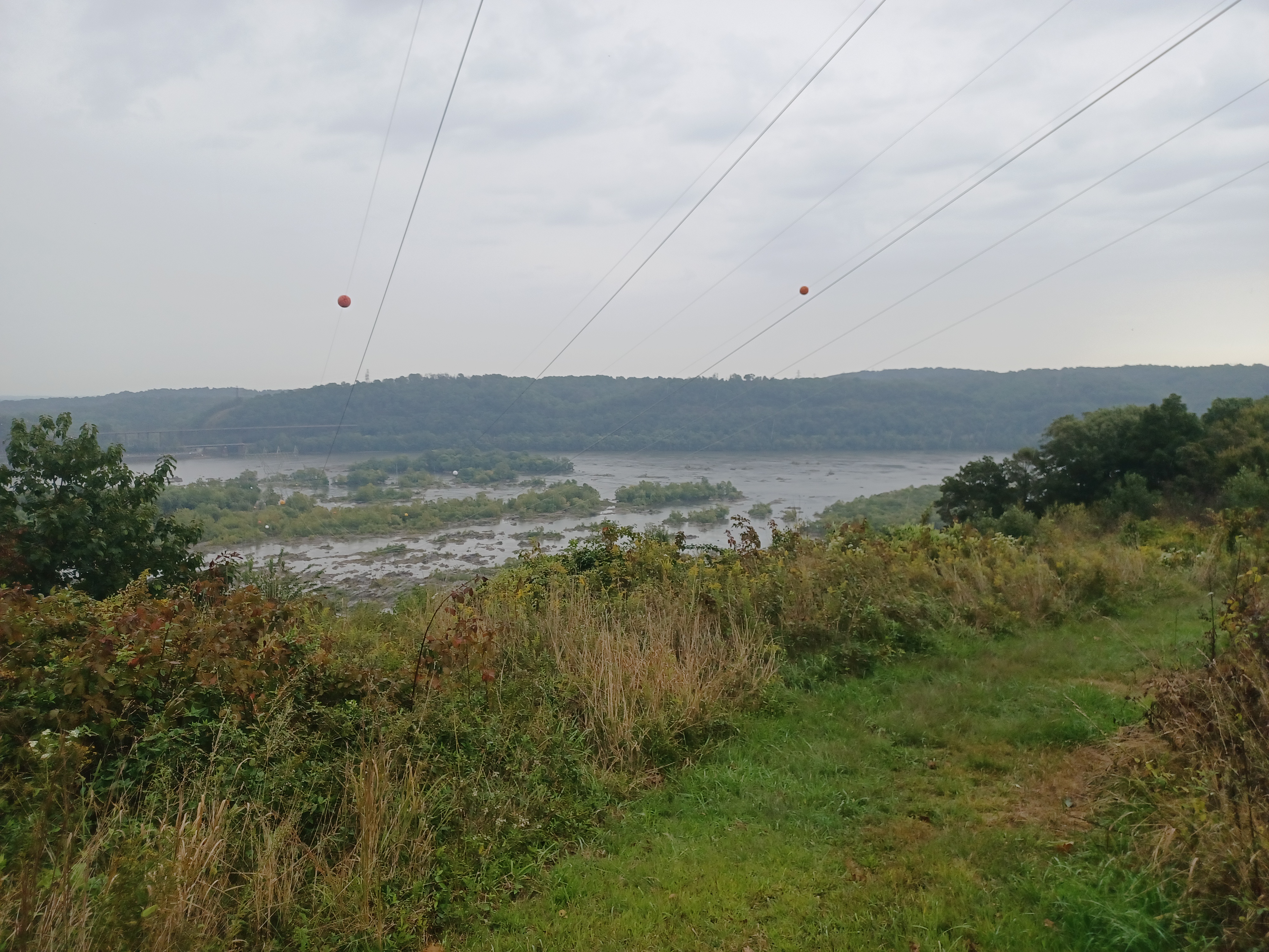
After only a short bit of woods, we emerged at a power line
clearing from which we were afforded a great view of the Safe Harbor Dam.
This dam was completed in 1931 and provides power for a lot of rail service I
understand. Next to the dam on the other side is the Safe Harbor Trestle of the
former Atglen and Susquehanna Branch of the Pennsylvania Railroad.

The line was created as a freight bypass of the Lancaster area, and still to this day has power lines over it in the catenary area that provides power for electric rail further east.

The Safe Harbor Trestle was recently decked for the Enola Low
Grade Trail (the line is nicknamed the Enola Low Grade Line). That route on the
other side was my backup hike in case I had my son with me, but because of
predicted weather, I couldn’t bring him anyway. There was a lot of rain
predicted, and we were in some drizzle.
The old Pennsylvania Railroad line crosses the outlet of the Conestoga River directly below the Safe Harbor Trestle and is still in use.

The Safe Harbor Dam impounds the Conejohela Valley to create Lake Clarke. The best view of the area was achieved just a little higher up on the power line.

The trail continued around a bit of a corner and then dipped down into the woods
again on the other side.
We descended to cross Boyd’s Run, and then climbed slightly on
the other side to where Apollo Shelter now is. I was thinking about taking a
side trip to the shelter, but it was uphill from the main trail route, so I was
happy with just taking a photo of it from below and continuing on.
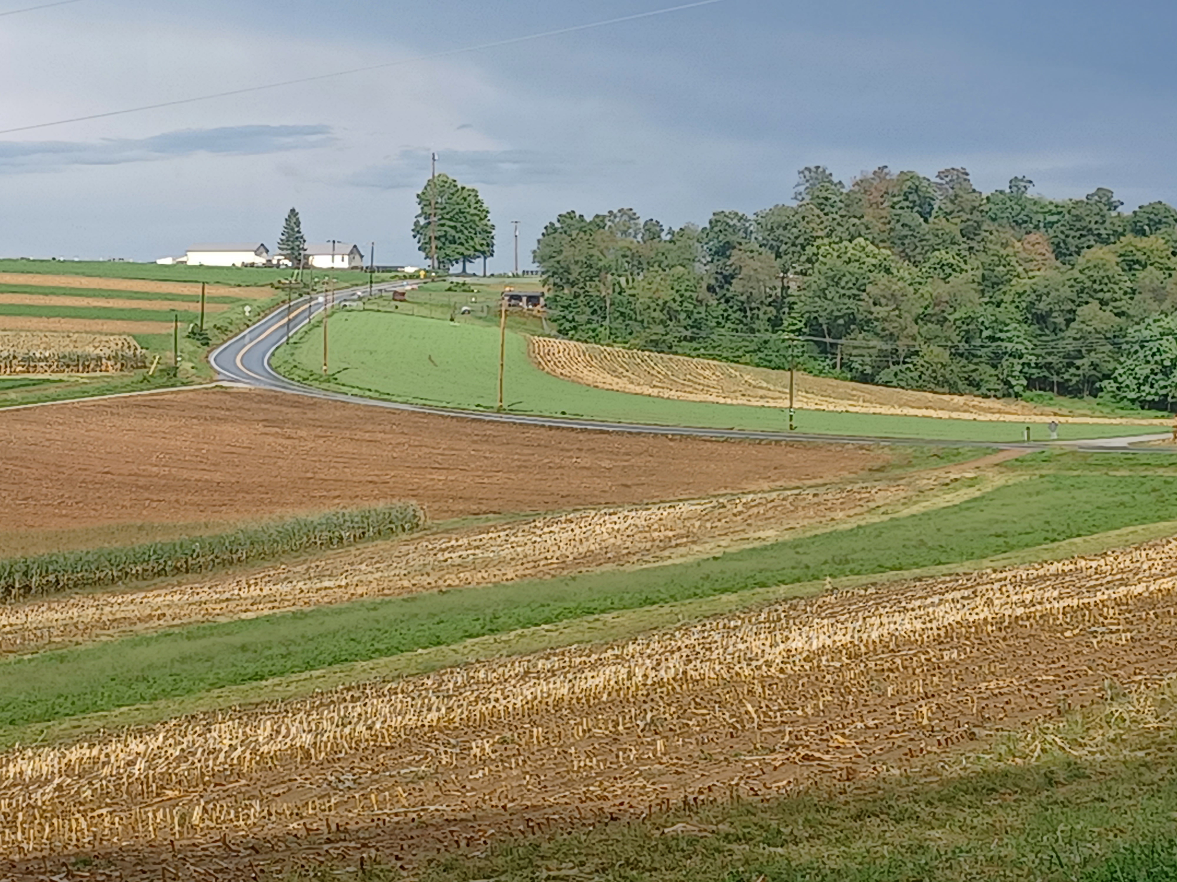
We climbed up through a dry run, and pretty soon emerged at the end of a cultivated field.

There were other trails on woods roads that intersected through this area, with one going left with numbered posts. We went straight along the field, then back into the woods parallel with it for a time.

The trail became super easy; it was just a woods road and adjacent farm field
access for a bit. We eventually came out at the Boyd’s Run Trailhead parking on
Shenks Ferry Road. The trail turned to the right there through a swath of
woods, which might have been a reroute since the time I backpacked this. I didn’t
totally recognize it.
I checked the website, and it was in fact a reroute in this area, completed in 2018.
We meandered through these woods parallel with the field, and then came out
into the fields. We continued to follow the edge of them, soon parallel closely
with Shenks Ferry Road.

We then crossed over Shenks Ferry Road into a swath of woods and began descending again. We were soon in an obviously planted grove of Norway Spruce heading south.

The trail emerged at the edge of the same power line we had been
on in the cultivated fields, and then turned left to skirt them down to and
across Furnace Road.
We continued along the undulating terrain and over Kline Road,
then descended through some attractive rock formations to the Otter Creek.
This is a weird bit of trail because it follows the Otter Creek, but then it
turns away from it and returns to it again.

We started heading downstream, and despite recent drought conditions, the creek had some nice deep spots. I really wanted to get in and cool off, but I held off for the first bit of this.

There was some giant junk that had washed down the creek, laying along the side
of the trail, which shows just how crazily this floods.
Otter Creek winds around beautifully. The scenery is always top notch going
through the entire area, despite the fact that there aren’t any actually any
waterfalls.
Some of the recent flooding did a real number on the trail. There were some washouts, and spots where it was a very significant cliff-like drop just to the right of the trail. A fall from there, and in slippery conditions we were facing, would not end well.

When we reached the point where the trail turned away from the creek to the left and started to switchback up to the north again, I took a break and went to lay in the creek.

I’d already worked up a sweat I wanted to
get rid of, and this was a great spot for it. It was really very cold though.
It was a steep climb up, far to the left, and then more to the
right, and eventually we came back out to Furnace Road directly across from the
parking area for Urey Overlook.
The trail followed a grassy old road straight ahead, parallel
with a farm road, then continued on the road into a young woods of stuff like
Birch and Hemlock.
Soon, we emerged at the Urey Overlook, with great 180 degree views ahead and up the Susquehanna River.

Upstream, we could see some of the Safe Harbor Dam complex, and straight across we could see the village of Pequea, where the Pequea Creek flows into the Susquehanna.

I had hiked through that settlement on the Conestoga Trail, as it is where that trail finally reaches the Susquehanna.

It
was quite a nice view, and made me think how I look forward to hiking the
entire Conestoga Trail again as part of my series of filling in all of these
trails in the middle of the 911 National Memorial Trail.
The weather was really nice at this point, but we knew there was some sort of bad stuff coming within an hour or two. I wanted to try to get to the Otter Creek Campground before that happened, because I knew it would likely cause flash flooding that would make places like the Otter Creek a hell in a few minutes.

We continued to the right on foot path from the mowed overlook, and began descending. At first it was gradual, and then via a switch back to the right.

It’s really weird in these Susquehanna lands, that we would descend
back to the Otter Creek so deeply downhill, while directly to the left of us
and downhill was the Susquehanna. It sort of creates an erosion ridge line.
The trail was co-blazed with a yellow one through this area.
We weaved around through woods for a bit, and found ourselves on more undulating terrain that went over some tiny tributaries. At one of the, with a brief down and up, the rock was super slippery at the bottom and I bent my toe very badly. It hurt terribly for a long while, and so I had to limp for a bit.

Diane also took a spill in this area, but probably because she was looking for Paw Paws.

Fortunately, she found some in this area! I’d never had one before, and I had
been curious about these things for so many years, so this was a big moment for
me.
Dave and I were in the front, and we waited for the others to
catch up. Diane had picked some of the best Paw Paws she could find, and had
plastic forks and such for us.
Paw Paws are the largest edible fruit native to North America, unless you count the Gourd, because that is considered a fruit as it grows, but when consumed it’s considered more of a vegetable.

Paw Paws are a native word from which we also get the name “Papaya”, and Colonists sort of mixed it up.

They’re quite different from papayas, although Paw Paws do have tropical family
members. Papayas in some areas are also known as Paw Paws, which is why we hear
Baloo sing about Paw Paws in the Jungle Book.
Our native Paw Paws vary in taste depending on where they are, and are sort of a
combination of banana custard and mango. It’s kind of a distinct taste unlike
other things. They’re very soft inside, and have enormous seeds that are
considered poisonous and must be spat out.

The best Paw Paws I learned are not the ones you pick from the tree, but the recently fallen ones on the ground beneath them.

From the tree, they can be too
hard to consume and don’t taste good at all, unless found at precisely the
right time.
Diane said that any effort to try to bring a Paw Paw home is futile. They are
so fragile, so short lived, that they will have gone bad by the time you get
them there.
Almost everyone who has tried has failed to cultivate them, and the few that have, like in the area where we were, charge up to $8 each for these fruits. People do go pretty crazy for them, and there are even Paw Paw festivals in areas where they grow.

I liked it, but it wasn’t the most amazing thing in the world. I wouldn’t pay $8 for one for sure, but I will definitely plan hikes around this season to be in areas we know to have Paw Paws.

We continued onward, and soon came back out to Furnace Road
again. The next rarity we found on this hike was a Volkswagen Rabbit parked at
the trail crossing, in very good shape.
Those things rusted out like crazy and I never see them in good condition. My
mom owned several of them when my brothers and I were growing up, and they had
holes through the floor where we could see the road beneath. She used to tell
us while we were driving not to put our feet down on the floor!

We continued across the road and descended back to the edge of the Otter Creek again.

The sun came out, and it was just stunning walking along the
creek with the light shining strongly through. The storm was still coming, but
this was certainly the calm before.
Some of this section of the creek was more washed out than the
stuff we had been on before. I could see that the trail would have been lower,
along the edge of the creek, but that it was required to move it further up the
slope because of these washouts.
When I had come through this area for the first time, I did one overnight trip
with the Metrotrails crew where we camped at Otter Creek, and we did what was
to be a new trail that follows the Otter Creek between the two sections of the Mason-Dixon
Trail.

I had thought that trail was completed, but it might already have been flooded out.

I remember being on bits of new trail during that trip. Maybe some
of what we were on was new Mason-Dixon Trail. I’m not sure what sections had
been rerouted, but it seemed that this bit, according to the website, this is
the same.
We had met one of the supervisors of the trail that day years ago, and I wish I
could remember his name. I might have it in the journal from that day but I’m
not checking it right now.
The trail climbed quite a bit above Otter Creek from time to time and there was really very good side hill work done. Quite impressive.

There were also some really nice deep holes for swimming out there, but I didn’t jump in again this time.

There were more beautiful big trees, and occasionally large junk
that had washed downstream. There are a few homes right on the creek just above
the public land, so it must have come from there or from people dumping off the
sides of roads.
When we finally emerged at Furnace Road again, a wooden sign
read that we had already come 5.9 miles from Apollo Shelter, which wasn’t even
as far as where we started, so that was good to see.
Directly across Furnace Road was the Otter Creek Picnic Area on the Susquehanna River.

While waiting for everyone else to catch up, I decided to wander on down and have a look along the river to see if I could see any remnants of the Susquehanna and Tidewater Canal.

The canal had been developed between 1836 and 1840 on the west bank
of the Susquehanna from its mouth at Havre De Grace Maryland to Wrightsville,
where it could connect with the Pennsylvania Canal Eastern Division on the
other side.
The canal remained in good use until about 1855 when competition from
railroads, flood damages, and interruption due to the Civil War made it hard
for the canal company to pay its debts. The canal sold its assets to the
Philadelphia and Reading Railroad in 1872, which continued to use the canal to
haul coal to Baltimore until 1894.

With the development of the power plants all along this stretch of the river, many sections of the canal are submerged, but a surprising amount of it is still out of the water.

We had already visited locks 1 and 2 on the previous
hike, and there would have been more in the area. There were still nine of them
I’d never seen before in the stretch.
When I walked down to the boat launch area, I was rather shocked to see that on
the north side of Otter Creek, stone remnants of the aqueduct that would have
carried the canal across the creek were still in place. They were mostly
submerged, but it was obvious what I was looking at.
Further, on the near side of the aqueduct site, the entire picnic area appeared
to be the filled in canal.

It went along the river downstream, and seemed to go
around a giant rock outcropping that must have been blasted through.
I was very happy to see some remnants of the canal I wouldn’t have known
existed.
When the others were all caught up, we headed along the trail,
which had crossed Otter Creek on the road bridge, and then turned up into Otter
Creek Campground on a paved path to the right, which used to be an entrance
road.
The trail passes along the camp roads for a bit, and passes right by the camp store, so of course we had to stop in for snacks and such.

I saw that they had their ice cream stand open, and it wasn’t insanely expensive, so I got a triple scoop of vanilla. It was filling and huge, but I was insanely happy with it. The ice cream was great.

Checking on the radar, it was about ready to start storming
pretty bad. We decided that it would be prudent to go over to the pavilion in
the campgrounds to wait out at least the heaviest part of the storm, because we
would be headed down along a creek pretty soon again.
We headed over there, and I enjoyed my ice cream. Diane watched me eating it, and said how good it looked, so we egged her on to go over and get herself one before we continued on. It didn’t take much convincing and she went back to get one. She made it before the storm really hit.

The rain was super heavy. It was a good thing we made it to this spot when we did. We were able to wait out the worst part of the storm and do the rest of the hike much happier.

John had not brought a poncho or umbrella, and he was wearing
jeans which would not go well. We reminded him that there was a camp store, and
that he could go back and buy a cheap poncho before we left, or at the very
least, manufacture one out of a large trash bag. He went back and fortunately
they had one for him to get through the remainder of the rainy weather.
We headed through the campgrounds, where there are definitely some somewhat permanent residents.

The blazes were not really as often on the trees as they should have been in order to find the trail route, and it seemed like we should be going straight.

By doing that, we went to a camp site, and I
stepped into the woods where I could see the small waterfall that I knew the
trail went by. Unfortunately, it was really steep to get down there. That wasn’t
the spot.
The others turned right through the campgrounds and made it to the height of
the land up there, which I really felt wasn’t the way, but I headed up there to
get them. A family in a camper came out and let us look at the map of the
campgrounds to show us where it said the trails were, but the Mason-Dixon Trail
was not even included on this map.

We headed back downhill, and Brittany said she saw what looked like a trail
with a wooden sign, but that everyone else kept going and paid it no mind. She
was right, and she headed to where she saw it.
We all headed to the trail, which oddly went right along the back of several
camp sites before descending to the edge of the Sawmill Run. Another stream the
trail follows a little bit ahead is Furnace Run, and I wonder if the main
stream used to be called Furnace Run, because the little settlement of York
Furnace is just below.

On the database of existing and previously existing iron furnaces of Pennsylvania, I could not find York Furnace, so whatever furnace used to exist just below along these streams, it must have had a different name as well.

The trail descended beside some incredible rock outcroppings, and then turned upstream along the Sawmill Run.

It soon reached a wooden foot
bridge right in front of a lovely cascade where we crossed. The bridge sat a
little lopsided, but still stood strong.
On the other side, the trail turned hard right, then hard left, and very
steeply climbed along the rocks on the other side.
The trail climbed up to reach the abandoned former route of Sawmill Road, which was still in pretty good shape, and a very relaxing bit to walk as we continued upstream along the stream of the same name.

A section soon after we turned onto the road had concrete barriers in place. I assume this section of road was probably open to traffic not so many years ago to have this in place.

The grade of it was still pretty good, and it’s even still on google maps. The first time I did it several years ago, it was already abandoned though.

The section was really beautiful and overall relaxing. One could hardly tell this was ever a road in many sections, where grasses were growing through the roadway and only the single file footpath was obvious.

We came to a point where the Furnace Run came to its confluence
with the Sawmill Run, and there used to be a culvert that carried Sawmill Road
over it.
There was a large corrugated pipe with all of the covering
washed from the top of it, and beyond that, stone work that appeared to have
been probably an earlier dry laid box culvert that must have failed years ago.
The entire area had JUST flooded. It was indeed a good thing that we had waited
it out under the Otter Creek pavilion.

All of the weeds were washed flat along the edge of the trail, because the water had come up from the creek and flooded right over it, and already went back down again.

If we had been out in that
mess at the time, we would certainly have gotten caught in a flash flood that
could have been dangerous or even deadly.
We crossed over this old bridge site, which might have been in
better shape the last time I walked it, and turned left on the other side onto
another abandoned road that gradually went uphill along the Furnace Furnace
Run. Some of this might have been in State Game Lands 83.
Pretty soon after turning onto the old road, there was a secondary road that
went more steeply up a hill to the right, while another stayed lower along the
creek.

I remained lower and called back to the others when to confirm we were going the correct way by seeing a blue paint blaze.

As we continued up the Furnace Run, it was even more obvious
that this area had been under water, and we passed a large fallen pine tree
that looked to have just fallen over. The weeds it knocked down looked so fresh
that I assume it had happened within the hour.
The trail became less and less like a woods road as it meandered slightly from the stream, past some beautiful rock outcroppings, then turned left to cross Furnace Run on stepping stones.

From that crossing, the trail started to climb more steeply, and it did so along a dramatic cliff face. It was an amazing little section of trail.

We continued uphill through these outcroppings, and weaved
between several more as we started to reach the height of the land.
Just as it started to level off, John and I both started to get stung at once.
These were some really painful stings, and the two of us hollered and began
running ahead as quickly as we could.
I kept feeling them, one after the other after the other and these ones were bad. I couldn’t believe they were out with such force, because it was still drizzling a little bit. I would think they’d stay nested like that.

Brittany was right behind me, and she avoided them to some degree, but then got one sting on the middle of her nose!

We hurried our way out to where the trail reaches a mowed swath
of a power line. We stopped to catch our breath, and then we started getting
stung again! We all started running ahead more along the power line clearing,
hoping that the drizzle would make them stop stinging us.
Eventually we stopped feeling the stings. I don’t know how many the others got
in this section, but I counted eight.
These weren’t ordinary yellow jacket stings either. Each one of the points of
sting were bleeding! This must have been some kind of worse wasp or hornet.

Dave and Diane behind us also had to run on through, and Dave apparently had them all over one of his fingers.

I think he said they looked kind of like
yellow jackets, but with more black than yellow in the stripes on their bodies.
We continued on the power line, which was picturesque since it
was on kind of a slope, and then came out to unpaved Bare Road near the
community of Airville.
The trail turned right on the gravel road for a short distance, and then cut
into a line of trees adjacent to a field and climbed uphill a bit more.

The trail came out of the tree line to a beautiful field scene just as the sun was coming back out.

It then followed the right side of the
field out to Furnace Road, directly across from the intersection with New Cut
Road.
The trail continued straight across here and followed unpaved
New Cut Road. There were fantastic farm land views all along this stretch
straight ahead, and I was very glad we wouldn’t be getting into any more nests
walking this bit.
We did have one car that passed us at a ridiculous speed. Why anyone feels the
need to kick up so much gravel on a tiny road like that I’ll not understand.

The road passed through a swath of woods, then emerged to more lovely farm land.

The sky was opening up to a deep blue, but the dark clouds of
the storm passing away were still on the horizon which provided for a lovely
ambiance.
We continued uphill a bit and came to the intersection with
paved Posey Road. This road is a dead end, so there was basically no traffic on
it at all.
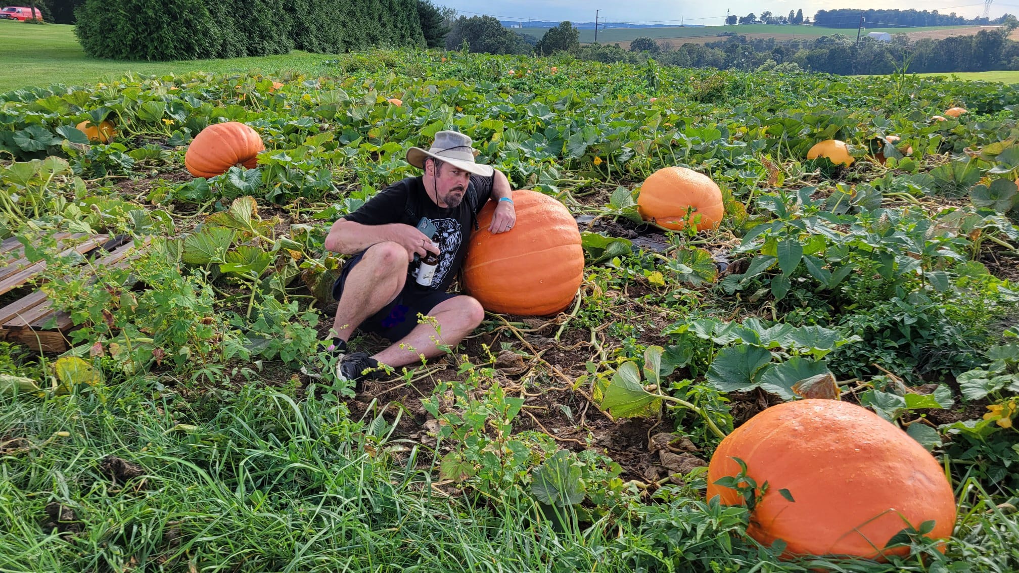
To both sides of the road, there were more splendid farm views, but to the right was an enormous pumpkin patch. These were enormous pumpkins, so impressive that I had to get a photo with one of them.

We continued downhill, passed through some more farmlands, and the road became unpaved.

I spotted an entirely orange wooly bear caterpillar moving its way across the
road, which I joked was a sign of a mild Winter to come, because the old
superstition was that the Winter to come would depend on how much black we
could see on the wooly bears.
Actually, this was more likely a different species of Wooly Bear that is more common further south, just like with the Paw Paws. This one will probably grow to become a Virginia Tiger Moth. The normal Wooly Bears become Isabella Tiger Moths.

We continued through more farm land, and then the trail turned to the right onto another gravel road. This brought us in to State Game Lands #181.

The road brought us to a parking area for the game lands, but it
continued ahead with a vehicle barrier gate. Mason-Dixon Trail continued on the
road heading gradually downhill.
The entire descent was just as pleasant as could be. We headed
all the way down to the edge of the Oakland Run, and the trail turned left to
follow it downstream.
I fell behind the rest of the group a bit, and I caught back up
with them at a beautiful place where there was a camp site, a fire ring, and an
incredible rock outcrop jutting forward looking like a Raven’s head.
We all sat down for a nice break here. It would be a perfect spot to camp if doing the trail for long distance, but it’s not a legal spot to do so because it’s on state game lands.
Once we were done with our break, we headed across the creek on stones, and started to climb steeply.

The trail cut to the left, and remained
high on the slope above the creek with some splendid views back down to it.
We got a little split up in this next section. Dave and Brittany were powering ahead pretty strong, and I was taking my time a bit because there was some somewhat technical stuff to step over. The trail went over a couple of rock outcrops high above the Oakland Run, and then continued through an incredibly dense understory of Rhododendron for a long while. I imagine the slope was pretty steep below me to the left, but there would be no way of seeing it through the thickness, nor would I be able to fall very far through it.

The trail reached a point where it turned hard left and descended steeply on a rocky trail toward Oakland Run.

While I was heading down, I could hear shouts from Brittany and Dave down below. I figured maybe they hit another nest down below.

I was moving along at a pretty good clip, but
there was no way of going very fast because this was a pretty technical
descent.
It was already too late by the time I saw a swarm of yellow
jackets around a nest in the left side of the trail. I was committed and I had
to push on through as quickly as I could.
I started getting stung almost immediately, and I had to keep my wits about me not to try running down this mess or I’d most certainly get hurt even worse, and getting evacuated out of this area would certainly not be at all easy.

I waved my arms around frantically trying to swat the insects away. At the bottom of the slope, there was a small path to a pool of water in Oakland Run I ran over to.

I threw my backpack to the side and laid down in the
water as quickly as I could to get the things off of me.
In doing this, I lost my glasses into the water, and I lost the lens from one
side. I was amazingly able to find both the glasses and lens, but I noticed
that the ring that I wore, which had a tree on it, that Jillane gave me soon
after our son was born, was missing. It had flown off of my hand while I was
swatting away at yellow jackets.
I had to lay in the water and wait for quite a while. When I looked over to my
backpack that I’d thrown to the side, there were still yellow jackets on it
attempting to sting it!

Eventually, they disappeared, and I got out of the water to make
sure I had everything. I walked back up the trail just a bit and looked at the
sides of the trail to see if maybe I could find my ring, but it was gone. I
wasn’t going to go back to the nest to find it, and it probably flew off into
the weeds from the narrow trail. I didn’t want to risk getting stung again.
I was upset to have lost the ring. I’d been wearing it almost a year, and I really liked it, but I also considered that maybe it was symbolic.

Jillane asserted that we are no longer in a relationship, and wanted nothing to
do with me beyond our son, and without anything that symbolized any union
between us, it would be that much easier to keep letting go.
I had yelled back to John and Diane so they’d know to watch out for the
stingers on their way down, and they still weren’t showing up. I waited just a
bit longer to see if they’d show up and tried to bend my glasses back into a
better shape.

My legs, arms, back, stomach, and shoulders were all covered in stings. I had at least fifteen stings by this time, but at least these ones were not bleeding like the previous ones.

The pain was awful, and everything felt tight trying to push down the trail
ahead.
The trail remained along the creek, and I soon reached a small
falls and a nice deep hole that was my intended last spot to stop and swim, but
I didn’t bother to get in again at this point. I just wanted to get out of this
area where I might get stung again.
I walked as quickly as I possibly could ahead, over undulating terrain close to
the creek.
When the trail looked level enough that I could handle it, I started running. I
just had the feeling that I was going to run into another nest and I couldn’t
handle anymore.

It was a good thing I did this, because I found out that there was indeed a third nest, and the fact that I’d moved so quickly over it kept me from getting stung again.

I didn’t slow down again until I went up slightly and reached the Susquehanna
again.
This part of the river is Lake Aldred, impounded by the Holtwood Dam
downstream.
The trail continued on undulating terrain along the river
heading downstream for a bit.
I stopped finally when I got to a concrete pad sitting over the river. I knew
at least there, there wouldn’t be any stinging insects to get me.

I pulled my phone out to see if I could get a hold of anyone else in the group, but there was no service.

My phone was calling out, but it was going to
voicemail and such for everyone else. I put my pack on, and figured the best
move was to just continue heading back to the cars. I was feeling really sore,
and I just wanted to sit down, but sitting flat on the ground would be too hard
to stand back up.
In this next section of trail, I came upon an enormous grove of Paw Paw trees.
The ground and trees were covered with the best looking fruit we’d seen all
day. I picked one up and it was perfect.

I gathered a few of them, and then looked at how much farther I had to walk.

Even though Diane had said that it’s pretty much impossible to
transport these things, I kind of took it as a challenge, and I thought that
just maybe I could pull it off.
I took my shirt off, and carefully placed as many Paw Paws on it as I felt I
could safely carry in it, folded it over on the corners, and then carried it on
my forearms. I moved briskly down the trail from here, but at a slower pace as
not to trip and drop these things.
Pretty soon, the trail reached an old abandoned road, with a clearing down below to the left.

This was the historic site of McCall's Ferry, where boats would cross to and from the Lancaster County side.

There was a log out along the slightly lower than usual water level, and so I
walked out there, put my Paw Paws and shirt down, and rested for a moment on a
log. The views up and down the river from this point were absolutely awesome.
As I looked
upstream, the single pier of the former McCall's Ferry Covered Bridge was in
view. I didn’t know before this that the pier was still in existence,
but I know about the bridge.
McCall’s Ferry Bridge was the longest single span
covered bridge in the history of the world, which opened in 1815.

"I can inform you now, with a considerable degree of satisfaction, that I have at length succeeded in getting up the long arch at McCalls Ferry. This arch is, without doubt, the greatest in the world." - Bridge designer Theodore Burr Febuary 26 1815.

Only two spans carried the behemoth of a bridge across the mighty Susquehanna River, one 360 feet, the other 240. It is a testament to the strength of the Burr Arch Truss which had become a standard for long lasting covered bridges.

Unfortunately, high water and ice swept this amazing bridge away in March of 1818, only some four years after the bridge was completed.

No bridge spanned the Susquehanna in the area again until the
completion of the Norman Wood Bridge in 1968, a couple miles downstream. The
bridge site today partially lies under the waters of Lake Aldred.
There was a story I read about a young Thaddeus Stevens crossing this bridge
before it was completed, and that his horse fell partially through the decking.
To the right from this vantage point, I could see the building and the breast of the Holtwood Dam.

This dam was started in 1905 and completed in 1910, and is the oldest of the modern Susquehanna dams.

It was originally named the McCall’s Ferry Dam, but it was renamed for two of the company executives. I think it’s an amalgam of the two names, Holt and Wood.
I got back up
and started heading south along the trail on the old McCall’s Ferry Road,
thorugh McCall’s Ferry Nature Preserve.
Pretty soon, the trail emerged onto River Road. To the right from this point,
the road is McCall’s Ferry Road, and it’s River Road straight ahead.

I continued walking the road ahead, and soon passed the Holtwood Dam warning
signs that read to exit the area if the warning sirens go off. I found out from
camping on this trail at Peavine Island to the south that the alarms sound
constantly and don’t particularly mean anything. There was also one of those
signs that gave a list of everything not allowed on the site, which redundantly
included “entry”.
Pretty soon, the Mason-Dixon Trail turned off to the right to climb the slopes once again, but I continued down on the road just a little ways ahead, past a great viewing area of the Holtwood Dam.

Pretty soon after that, I limped on to the parking area where we’d met in the morning. Brittany was standing out in the road and called out my name, happy to see me.
Everyone else had made it back! I don’t know how they did it or how John and
Diane had somehow passed me, but they did.
It was still daylight, so I was pretty happy. I managed to get
the Paw Paws to the car, and I sat them in my son’s car seat in order to keep
them safe to get them home.
I was still out of it and being medicated from the Lyme disease or whatever it
was, and the week to follow ended up being super stressful for various reasons.
Among them, my wallet went missing.

I had no idea what could have happened to
it, and it caused everything to be more difficult than it already was.
When I got the Paw Paws home, Jillane wouldn’t eat any. She
wouldn’t even try. I ate one of them with my son Ev, and he seemed to like
them. I brought one up to my grandfather to try, I brought one in to work for
my coworkers Bruce and Tom to try, and I split another and gave half each to my
next door neighbors. I ate one more by the end of the week, and they amazingly
kept good.
At the end of the week, on the Saturday night before the next hike, I finally
got Jillane to try some, the best one that I had managed to get home. All of
them ended up being good, and lasted as much as the entire week after bringing
them home.
This had been another great adventure. Some of it is the stuff that is only fun
in retrospect, but most of it was great.
No comments:
Post a Comment