

Hike #1621: 9/1/24 Spring Creek Estates to Allentown with Kirk Rohn, Evan "Joe Millionaire" Van Rossum, Alyssa Lidman, Galya, Diane Reider, Jenny Tull, Professor John DiFiore, Dan Lurie, Violet Chen, James DeLotto, and Everen

This next hike would be a point to point focusing on the Little Lehigh Creek and its associated greenways through and to the west of Allentown Pennsylvania.
I'd done a whole lot of this in the past, usually as part of my March on Musikfest hikes. Both sides of the Little Lehigh Creek have trails on them much of the way through Allentown, and so we did portions of it in the past as parts of my Musikfest hikes.
This time, I wanted to do something that would revisit some of the best of these areas, while at the same time, we would cover more of the greenway to the west that we'd never done before. There are a whole lot of preserves, none of which are so far from home, which I never got around to doing maybe because it was too easy.

I started looking it over, and realized a whole lot of it could be done with a stroller. It would be great for a Summer trip where I just needed to get into the water!

I planned it out, and decided on meeting at a lot along Martin Luther King Jr. Drive in Allentown, which is almost directly across from Harry A. Roberts Plaza, a little corner park area.
From that point, we would shuttle to the start point, which was a small park called Spring Creek Park, which is just outside of Trexlertown in a development community called Spring Creek Estates.
The morning started out kind of crazy for me, and I didn't know what to think had happened.

I usually get everything I need ready for the hikes on Saturday, so I have just about everything ready on Sunday morning.

Most everything I needed was in my new van, including my stroller and all of Ev's stuff.
I woke up early, with enough time to get everything together, and usually I go and get my car and pull it up to the house to put Ev in.
On this morning, I woke up, and my keys were not hanging up. I remembered I put them on a table the night before because I'd had an oddball incident the day before.
When I was walking back to my house around the corner after work (I have to park a couple of blocks away), a young squirrel ran up to me. I was rather surprised to see it come up to me.

Next, it climbed up to and perched on my shoe. I didn't know what was going on. I thought maybe it was rabid. Then, it started climbing up me.
The squirrel ended up sitting on my shoulder, and I stood still wondering what was going to happen next. Jillane was calling me and telling me Ev was waiting for me at the front door.
I figured I had better just head home with my new friend on my shoulder. I went to the door and Ev was there waiting for me, and I introduced him to the squirrel on my shoulder.
He was so excited that he went running up the stairs to tell his mom in bed that daddy had a squirrel sitting on his shoulder. She didn't get up and wasn't particularly interested, but I had to figure something out.
I was texting Animal Control officer Robbie about what I should do, but he wasn't getting back to me.
When I got no response for a bit, I texted Olivia Stettler, who had worked at Woodlands Wildlife Sanctuary down in Pittstown about what I should do. She gave me the number and instructions.

I got Ev ready to go, put the squirrel in a box with a towel, and we took it down to Woodlands for rehabilitation.

It turns out, squirrels are odd mammals, because in times of despiration, a young squirrel will turn to any other mammal, human or otherwise, for help.
This one chose the right guy, because it looks like it'll have a good life and proper rehabiliations.
Woodlands Wildlife Refuge is a non profit organization that works with wildlife for just these such issues, and survive solely on donations, so they're pretty awesome.
Ev and I got home, and I put the box, towel, and other stuff from the car onto the table where Ev usually eats his dinner. I recall placing my keys there as well.

I was tired, and it was getting late. We went through regular nightly routines, and I thought we would be ready to go when we woke up in the morning.
Before I even woke Ev up, I could not find my keys. I had no way into my car, and no spare set yet. I didn't know what to do. Both Dan and Jenny were waiting to meet up with me to carpool to this hike, but I was falling behind. I spent about a half an hour searching for them, and they were nowhere to be found. Not on the table, not on my desk where I usually leave them.
I let Jenny and Dan know what was going on, and I continued looking, running around the house like crazy. I ran twice out to the van and tried peering in to see if just maybe I'd left them inside somehow. There was nothing.
Finally, in desperation, I asked Jenny if she wouldn't mind driving to this one. I had two spare strollers. One of them Dan gave me recently, and the other was in Jillane's car, which had a pivoting front wheel, an important component for the hikes.

Usually, Jenny has a car seat in her car for her grand kids, but she didn't have one this time.

The most desperate measure was taking a chance with Jillane's. I would have to go in the house, take her keys, use the stroller from her car, and take her car seat out and use it in Jenny's car.
We moved fast and got it done. I brought Ev and and secured him in the seat in Jenny's car, and we were on our way. We ended up only running a little bit behind. I think I had John handle car shuttles from the meeting point to the start point.
My stress level has been high just about constantly as of late, but this was just too much to deal with. Even worse, I had no alcohol with me to take any of the edge off at all.

I'm fortunate that I don't need it. I never drink except for when I'm going to be spending a full day hiking, save for special occasions like weddings and all.

I actually can't keep any alcohol in the house even if I wanted to. When my Honda Element got destroyed while parked recently, I had to bring everything out of it, including two four packs of beer that I'd had sitting in there prepared for a hike. Ev's mom ended up stealing it from me.
Our starting point was a parking area in Spring Creek Park, near a playground, accessed off of Goor Street I think in Macungie officially.
Ev ran around and played a bit while I got things together. I had to be ready with a new container of wipes, diapers, drink container, etc. I didn't have the time to get many snacks ready either.

I finally had everything ready. I'd never taken this stroller on a long hike yet, and I really wanted to give it a try in situations that would be less crazy, but that wasn't an option. It would get its baptism of fire.

We began hiking along the east side of the park, toward the dog park area, and then cut through the grass directly out to Spring Creek Road in Lower Macungie Township.
Across the street from this point was a paved trail, which started only just slightly east of where we emerged on the road.
The trail eventually, as I understand, is to cross over the Little Lehigh Creek just to the south, because there is a trail directly on the other side, but it's apparently not funded yet.

We continued walking to the east on this paved path, and then turned to the right as it turned in a small meadow flood plain area.

We walked into these woods just a little bit, and the trail led up and over a foot bridge across the Little Lehigh Creek. This was not the way we were going however.
To the left, there was a mowed path that broke off of the surfaced one, and continued parallel with the downstream creek to the east. We began following that, still parallel with Spring Creek Road.
To the left, visible on the road, was an old farmstead, which according to the 1876 Atlas of Lehigh County, belonged to Jacob Stephen.

We continued through the grass and angled to the right. One good thing about this stroller was the good shocks, a little better than what I'd had on my regular one.

The grassy swath led us out to Mill Creek Road, where we turned right, heading south. There was a good view of the creek along the road to the right.

Just ahead, there was what appeared to be a public pull off to the right of the road, with sort of creek access. We opted to follow this route back for a bit.
It was somewhat clear for a bit, and pretty, but obviously not too regularly used. The path got worse and worse as we continued, and it brought us along the edge of an old farm pond, out behind homes off of the road. It then got rather impassable, and we had to turn back for a bit.
We found our way through some fallen sticks, an then some really thick grass. The trail I was trying to follow went along a buried utility right of way, an once we were back to where that was, we were okay, although it was still not easy pushing. Every stick that had fallen from a tree was a chock in the wheels, and pushing through the grass, which was sometimes more than hip deep, was a real chore. It often required some help to push or pull Ev in the stroller through.

Eventually, we made our way to where this path came out, on Mill Creek Road to the north of the Schmoyer's Mill Bridge. We turned right and crossed here. Downstream, there used to be a mill that stood to the right. Beyond that site, to the right, were some handsome old houses on the right side of the road.

The 1876 F. A. Davis Atlas of Lehigh County shows this as the home of T. Schmoyer, and the next house, D. Danner. It would seem that this Mr Schmoyer was the miller from the aforementioned mill.

We continued up the road past these houses, and past a rather new development. Before we came to the next intersection, there was a handsome old bank barn on the right, which the atlas maps seem to show belonged to the same or another member of the Schmoyer family.
At the end of the road, we had to cross and turn left along Sauerkraut Lane. There was a good sidewalk on the south side, which went along the green space of Willow Lane Elementary School.
Along this road, on the north side, there was another old handsome stone house, which the atlas maps also said was once part of the Schmoyer family. It looks like it might today be part of the Board of Education, because of all of the vehicles parked outside of it.

We continued to the east past the school, to the intersection with Willow Lane. We crossed at the crosswalk, and continued straight ahead for a short bit, then went up a slope to the left and continued on mowed trails in a small meadow parallel with a development. This is the Willow Lane trails, which are short, but a nice break between road walking.

We continued through these meadows for a bit, and took the fork to the right that comes out on Thistle Road. We took the longer route through this system, to keep it nicer, and then used the furthest north access. We turned left on Thistle Lane and continued to the intersection with the road called Eli Circle.

We went straight across, and up into the circle itself, a bit of green space in the very center of the development, all mowed. We walked directly across it, and came out at Eli Circle and Cross Creek Road. A short distance up Cross Creek Road, we turned left on a paved trail that led up into Brookfield Park, which has a paved loop around it. We kept to the left side of it, and then turned to the right where there was a playground. We stopped here to let Ev play some more.

Once we were done with our break, we headed to the road to the north, Loyola Road, and turned right. We continued on this downhill, and half the group got held back petting a cute dog someone was walking.

We continued and reached Stonewall Drive. The sidewalks ended, so we had to go in the road.
We reached the end of Stonewall, and turned left on Fresh Meadow Drive to the north and east.
DeLotto was getting ready to meet up with us, and had been in touch with me during the course of the trip. I let him know roughly where we would be, and he was heading our way.
We followed this road out to the intersection with Princeton Road, turned right, and then came out to the much larger Brookside Road.

Just as we were crossing over this road to where the trail went into Danfield Run Recreation Area to the left, Delotto pulled up in perfect timing!

We all continued walking down onto the paved trail to the left, which paralleled Princeton Road, and Delotto headed up that road to park at connective Spring Ridge Crossing Park, where he could head downhill and reach us on these trails.
This trail was pleasant, with wide mowed edges through woods and behind houses. We came close to Little Lehigh Creek again, and a side path led to the right when we reached Spring Ridge Crossing Park. Delotto cut down from here to us directly through the grass.

Togehter, we all headed across a rather wide meadow, and then into another swath of woods to the east, just above the creek that was to the north of us.

Soon, we emerged on Wild Cherry Lane at a parking area, where the Little Lehigh Creek bridge was directly to the left. This was a rather older bridge, with no pedestrian lane.
There was some sort of open space across the creek, but we needed to be on the north side, and there was no trail there. This would end up being one of the only bad bits of the hike.
We had to walk up Wild Cherry Lane to the north, and my plan was to cut across developments to the right in order to cut a corner.

However, the two roads going in, Williams Way and Steeplechase Drive, were both prominently marked as private drives with no trespassing signs. I didn't want to have trouble walking through.

Maybe if the others were all caught up I might have tried it, but we got pretty segmented here. Only Jenny was caught up with me going up this gradual hill, and there would be a lot of waiting around at intersections. I decided to just keep going.
A sidewalk began alongside the road after the intersection with Steeplechase.
We reached the intersection with Lower Macungie Road, and turned to the right. The sidewalk continued nicely through here, to the intersection with Macungie Road. Beyond that, we just had to walk the shoulder.

We continued on the shoulder ahead, and soon came to the intersection with Mill Race Road. We just kept going straight, and soon passed over the top of the the PA Turnpike Northeast Extension Rt 476.

We continued a little bit further up the road from here, and soon there was an old abandoned barn building on the right side of the road.
The 1876 Davis Atlas of Lehigh County shows this was part of the farm of J Desch. Near this spot, Mill Race Road connected with Lower Macungie Rd, until it was bisected by the Pennsylvania Turnpike, and the north side was rerouted to join a little bit to the west where we had just walked by.
It's not obvious where the road used to go when just walking by, but aerial images makes it pretty clear where it used to go.

We continued straight ahead, over the hill, and then down to Rt 29, Cedar Crest Blvd. Here, we turned right briefly, and then to the left onto Farr Road, which is the earlier main road alignment.

We had to wait up at this corner for the others to catch up. I had gotten really far ahead, and then Jenny was the next to catch up with me. When I'm not drinking a beer or anything, I tend to go much faster and not even think about it.
Once everyone was back together, we moved on down the road to the north. On the left, there was a handsome old stone house, which Kirk told me he had toured once before. I think this was purchased by the Rodale family at some point in more recent history, but I'm not sure.

The 1876 Atlas of Lehigh County shows this as the home of H Riegal. We continued past, and on the right was a beautiful old, converted mill building.

The historic Kohler (or Kehlor) Grist Mill sits directly on the Little Lehigh Creek in Lower Macungie Twp. This mill was built in 1806, and was converted beautifully to a private home.
It has been reported that this mill still has some of its original equipment, which is rather surprising considering its status as a home today.
We continued up the road, a bit closer to the creek, and then came to a driveway on the right, where the road starts to go uphill a bit more. This would be our turn into the Pool Wildlife Sanctuary.

I had been wanting to get to this place for probably the better of twenty years. I've had maps of the place in my collection and "to do" list for as far back as I have been seriously planning the hikes.

There was a little sign pointing the way in, but otherwise it really looked like an unassuming driveway.
We started following the gravel lane, which rather closely paralleled the Little Lehigh. We passed by one private house on the way, and we just waved hello as we went by. One guy was outside and waved back.
On the right side of the roadway, there were some good views of the Little Lehigh Creek, and lands beyond it with some really knightly.

At one point, there was a handsome little dam directly across the creek, but that was private land, with a house right next to it, so I didn't dare try to go in.

Pretty soon, we reached the parking and buildings for the Dorothy Rider Pool Wildlife Sanctuary.
The preserve was the vision of Air Products founder Leonard Parker Pool.
Pool was a founding member of the Lehigh Valley Conservancy, now known as the Wildlands Conservancy, and he bequeathed the property, a former cattle farm, to them in 1975.
Splendid, well groomed trails weave around the property. I decided we would try to get around this trail system to the left, and we entered trails near a visitor center.

The center was open when we got up to the door to it, but we continued along this edge. I wanted to do a good amount of the trails, but still try to keep to doing the easier stuff. There's one private home at the end of a driveway section we had to walk from near the main entrance, but lots of other pretty stuff.

There was a sort of mural along the wall of a shed that had the life cycle of a Monarch Butterfly, and a sign reading that we were 2,000 miles from the Mexico border.

We continued from here past the old farm house on the property. According to the 1876 atlas, it had been the farm of R. Romig.
We weaved around a corner on a gravel access road to the north, and then came to the crossing of Pheasant Trail. We turned right here.
The trail was surfaced with wood chips which made it really easy to push the stroller over.
We continued down this trail, and there was a beekeeping area off to the left. These of course look like a bunch of white drawers, and I had to keep Ev from running off toward them.

Ev has still never been stung by a bee, and I'm dreading the day that he is, because in case he's allergic, it could be really bad if we're in the middle of nowhere.

We continued along this trail to the next intersection, where there was a bench and a Shingle Oak. Trees through here were labeled, and there were plenty of interesting ones. I pointed out a Yew tree to the group as well.
From here, we continued onto the Flood Plain Trail, which in a short distance turned into an amazing, new boardwalk structure. The wood was still pretty yellow, so they probably only completed it within the past couple of months or maybe even more recently.
Dan held back earlier to use the restroom, and then waited for us to arrive at a pavilion in the main area of the preserve. He really missed out on a major highlight of the hike, but I'll have to come back to do more of this preserve in the future. The entire thing of what we had done so far is worth doing again, because there are many different variations of it.

The boardwalk continued on for a very long time, and it was just beautiful. Side trails also were given the boardwalk treatement, with bridges over more wetlands. At one point, we could see that there were earlier boardwalks and bridges taken out of service, and one abandoned one was visible between sections of the new stuff.

Ev ran the entire length of this, just because it was so nice and interesting.

When we got to the other side, we turned over to the pavilion and took a little break for a bit.
Violet was so impressed by this place that she decided to stay here and not continue on with the rest of the hike. She wanted to explore more of it, because there was so much more to see, and her husband Sam would pick her up there later.
The rest of us continued out to the bridge that crosses Little Lehigh Creek, out to the road known as Orchid Place. We turned left here, and then passed some lovely old houses on a narrow section.

The 1876 atlas maps showed this as the site of Romig's Mill, so one of the dwellings is probably the converted mill, and at least one other must have been a miller's house. One building leaned rather oddly like it is ready to fall into the road. It was really interesting, tight little area of the road.
We went uphill, which felt like more of a chore than I was anticipating, to Riverbend Road where we turned to the left.
This was by far the worst part of the entire hike. A long road walk that dragged on forever, and had ups and downs. There was really no other good way that I could see of moving ahead.

The next destination would be South Mall, just outside of Emmaus, where we would have our lunch break, but that required road walking that didn't look fun.

In retrospect, I should have turned right from Orchid instead of left, and then gone through more developments with better shoulders. If I do another variation of this, I will definitely be doing that next time.
We continued downhill on Riverbend Road, which sucked, to the intersection with Country Club Road where we turned right.
The Lehigh Country Club had land on both sides of the road, and a good golf cart path crossing. It would have been so tempting to just turn off and follow the golf cart paths, but we probably would have been stopped, so we continud on the road.
I again got far a head of everyone else, and only Jenny was really keeping up.
On the left, there was a handsome, stone bank barn. Beyond and behind it was a beautiful stone house. This was, at the time of the 1876 atlas, the farm of H. Kemerer.
We continued ahead on the road and passed by a county marker, which wouldn't make sense because were were totally in Lehigh County, but I think this one marked the boundary between Lower Macungie and Salisbury townships.

This road was horrible. There was almost no shoulder, and people were driving far faster than they should have been. I just wanted to power through and get it done.

When we got to Keystone Road, and into the other township, the lines disappeared and traffic slowed. It became residential, and there was good room to walk on the sides.
I pushed ahead of the rest of the group fast, through the development. I came to Bevin Drive, and then there was a parking lot to the right before reaching Regent Way. I cut into this, crossed, and then went up a hill of grass to reach Regent Way.
I hurried up this road, and then came to the south side of the lots for the South Mall. Ev was tired and fell asleep just before arriving here.

My stress level was really pretty high at this point, and I very much looked forward to getting something to drink at the Fine Wine and Good Spirits store at the far end of the mall.

I was so far ahead of everyone else that I powered on by every storefront and just went there, where I looked around and found some stuff, I think Bird Dog Honey Whiskey and some 19 Crimes wine I think I got.
Much of the group followed me to the end there, and then I slowly walked back along the front of the mall to the nearest entrance we could get in.
The entire north side of South Mall is closed off to public, with most of the stores there closed. Some of the anchor stores at that end are accessible only from the outside entrances.

The site started as Hess's South, a satellite location of Hess's downtown Allentown department store, in 1971. Hess's developed a small, enclosed Mall on the north side in 1975.

Crown American purchased the site in 1979, and they doubled the size of it in 1986-87. Jamesway anchor opened its 100th store at the site at that time. That was one of those stores I grew up with, because there was one in Mansfield up until just before I graduated high school.
While business has declined, and a section of the indoor mall is now closed, this site has done a reasonable job of filling spaces.
We went inside, and there was a hot dog place on the left called Yocco's, and Dino's Pizza Teria on the right.

I decided to go in and get a couple of slices of pizza. Ev would probably wake up soon, and I would have some of it waiting for him when he did.

I was apparently hungrier than I realized, and I ate the entire two slices well before he woke up. It was actually pretty good. I think I selected mushroom slices.
When Ev finally woke up, I had to go in and get him another slice of pizza, which he ate some of, so that was good. I had also gotten an RC Cola initially. I hadn't had one of those in many years, but they had them here.
It was really tastier than I'd remembered, and Ev had some, so I had to go in and get another of those as well to continue with.

Before leaving the mall, I headed to the restroom to give Ev a diaper change and unload as much of the garbage from the stroller as I could. This one had much more limited space than my regular one.

Once we were done, I called members of the group to meet me by the restroom to continue on.
Once everyone was together, we were on our way out the back of the mall to the west again.
I knew exactly where to go from here, because I had started at least a couple of the March on Musikfest hikes at this location.
We made our way directly through the mall lot, and then off of the corner of the parking lot through grass on a connection out to Regent Way. We turned right, and then reached Bevin Drive, where we turned and crossed over into Devonshire Park.

We skirted the right side, north, the entire way for a bit. This took us through grass and parallel with a dry tributary. We tried to stay in the shade because it was so ridiculously hot.

The slope of the grassy hill in the park became too steep to stay all the way to the north side, so we had to go uphill to the top of it for a bit. We continued to the northwest side of Devonshire Park, where there was a good footpath down to and across the dry creek bed. I needed a hand getting Ev in his stroller up and down through this bit.
On the other side, there was a nice meadow that had the edge mowed through it as a trail. We turned left here, and the path passed through a line of trees to a second open field area, and then out to a driveway road. We turned left on this, and emerged at Keystone Road where it crossed the Little Lehigh Creek.

The Keystone Road Bridge, also known as Keck's Bridge, was reportedly built in 1954, and it appears to use the old masonry abutments from its predecessor(s).

The bridge is a small deck girder open grate floor, which have come to be known affectionately as "singing bridges" for the humming sound crossing vehicles make.
We turned right and crossed the road bridge, and then in a short distance, descended on a grassy path down below, closer to the Little Lehigh Creek.
The pleasant, mowed grassy swath continued along the creek, with a good buffer along the wetlands, sometimes with new and recently planted trees along the way. When the grassy swath was coming to an end, there was a little path over to the creek.

We used this as a good break spot. I went over and laid down in the water immediately. It was quite refreshing, and others joined me as they arrived behind me.

Ev had fun playing around and throwing stones and such in.
From here, we continued back out to Keystone Road, as the grassy area ended. We passed the crossings with Devonshire Road on the left and right, and then continued along the road to the north a bit. The grassy swath started back up again, but there was no good access to it with the stroller, so I stayed on the road for a little longer.
Soon, we were able to get back down along the creek through the grass again. There was more plantings of trees as stream restoration projects to the right in this swath as well.

We continued ahead, and soon had to make our way back out to Keystone Road again. We passed the intersection with Briarwood Lane, past some historic old homes, and remained on the grass to the right of Keystone Road as we headed north.

Soon, we reached Fish Hatchery Road, with the historic hatchery straight ahead. This time though, we turned to the right on the road and crossed the Little Lehigh. Just beyond, there was the first of the walkways on the left, paved at this point. This was the start of our hiking on the Lehigh Parkway.
The Lehigh Parkway is a 629 acre Park preserve on the Little Lehigh Creek. Land preservation began in 1928, and City Planning Commissioner Harry Clay Trexler donated 30 acres including his fish hatchery to begin the project, then convinced other landowners to do the same. Development of facilities begin 1930. The area was subject of many Works Progress Administration projects during the Great Depression as well.
We stopped under the first big tree, a giant Black Locust, for the others to catch up before moving on.

We continued along the trail, which soon made its way toward the edge of the Little Lehigh again.
The Museum of Indian Culture was just to the south of us, and eventually I want to do a trip where we visit there, but this time we had to move on ahead.
The paved trail weaved to the right and remained in the open areas, but an unpaved and much more rustic trail continued straight. We followed this into the woods along the creek, and beneath some lovely Weeping Willow trees.
We emerged from the woods at a fly shop that occupies an old spring house. The Farmstead here has structures dating from the 1750s to 1850s off to the right. We continued into the edge of a parking area ahead.
The property was that of B Schmoyer in 1876, again according to the 1876 atlas.
A pedestrian only bridge crossed the Little Lehigh to the left, but my plan was to keep our trajectory pretty much to the south side of it. We would explore more of the north side again on a different hike in the future, possibly a variation of this one.

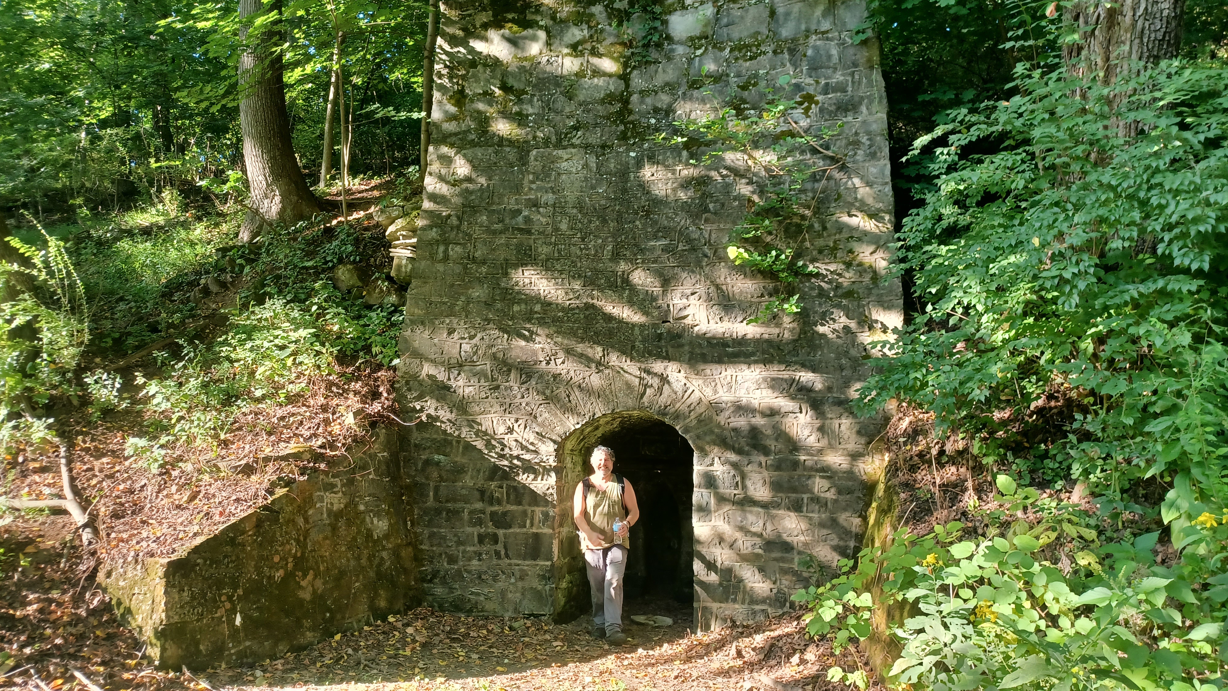
The trail ahead was originally a bridle path for equestrian use. We soon passed a handsome stone lime kiln to the right, which reportedly dates back to about 1850.

Pretty soon, we approached the attractive bridge that carries Interstate 78 over the Lehigh Lehigh.
This is a very large arch span structure all painted a clean looking white. It almost looked like something out of one of those antique, ideal postcards.
We passed beneath the bridge, and I think I quickly took a dip in the water again beneath before moving on.
It wasn't very far from this point before we came up to the Oxford Drive bridge. The trail goes beneath this bridge to the left. Just beyond, we approached Bogert's Covered Bridge.

We had been to this bridge before, and in fact, it has served as the backdrop for our group shots in the past.

Bogert's Covered Bridge was built built in 1842. It is the oldest covered bridge in Lehigh County Pa. Along the Lehigh Parkway and open to pedestrians only. It was built on the site of an earlier crossing of a sort of stick type of construction I understand.
I got our group shot with everyone posing on the south abutment to the bridge.
We went up from here, and walked across the Burr Arch span, which was quite handsome. There were signs inside saying that the bridge was to be rebuilt. It did feel to me like it was drooping down more than on the previous hike I'd done across it.

When we emerged on the north side and the trails there, there was an old log hunting cabin, or Abraham Kirper Cabin, dating to 1738-1741. The structure was refurbished in 1938 as part of the Parkway.
There is an old stone house on the south side of the bridge, which reportedly was home to the Bogert family for whom the bridge takes its name.

After our break, we continued on along the trail along the south side of the creek. In a short while, there was an old spring house and tributary to the right.
After a nice wooded section, there was an open area, below the Allentown Police Academy, where more trees had been planted along the river banks. Another foot bridge crossed over the creek in the vicinity of the police academy.
The section to the south of the creek remained somewhat close to Park Drive for a time, and part of it became a "Solar System Trail". I had never noticed another one of these before, besides the one at Voorhees State Park, and that one isn't really out of place because it leads from the observatory there.

The interpretive panels were spaced a bit, and have each of the planets and other stuff on them.
A little further ahead, up the slope to the right and visible from the trail was the historic Kemmerer homestead, which is part log and part stone.
The original log cabin section was built some time before the American Revolution when the Kemmerer family settled here. The stone addition was built about a century later, and the log section was covered with clapboard making its original construction style unrecognizable for years.

The house was purchased by the city, and in 1941, refurbished the building for use as a sub-office for the park.
The trail soon came out right along the Park drive for a bit. Despite the easy access of vehicles, it was not overrun by people. A little bit of loud music, but mostly people just having a nice time beside the creek. The first thing that stood out to me was the near complete lack of trash anywhere. People were partying, but doing so respectfully without leaving litter.
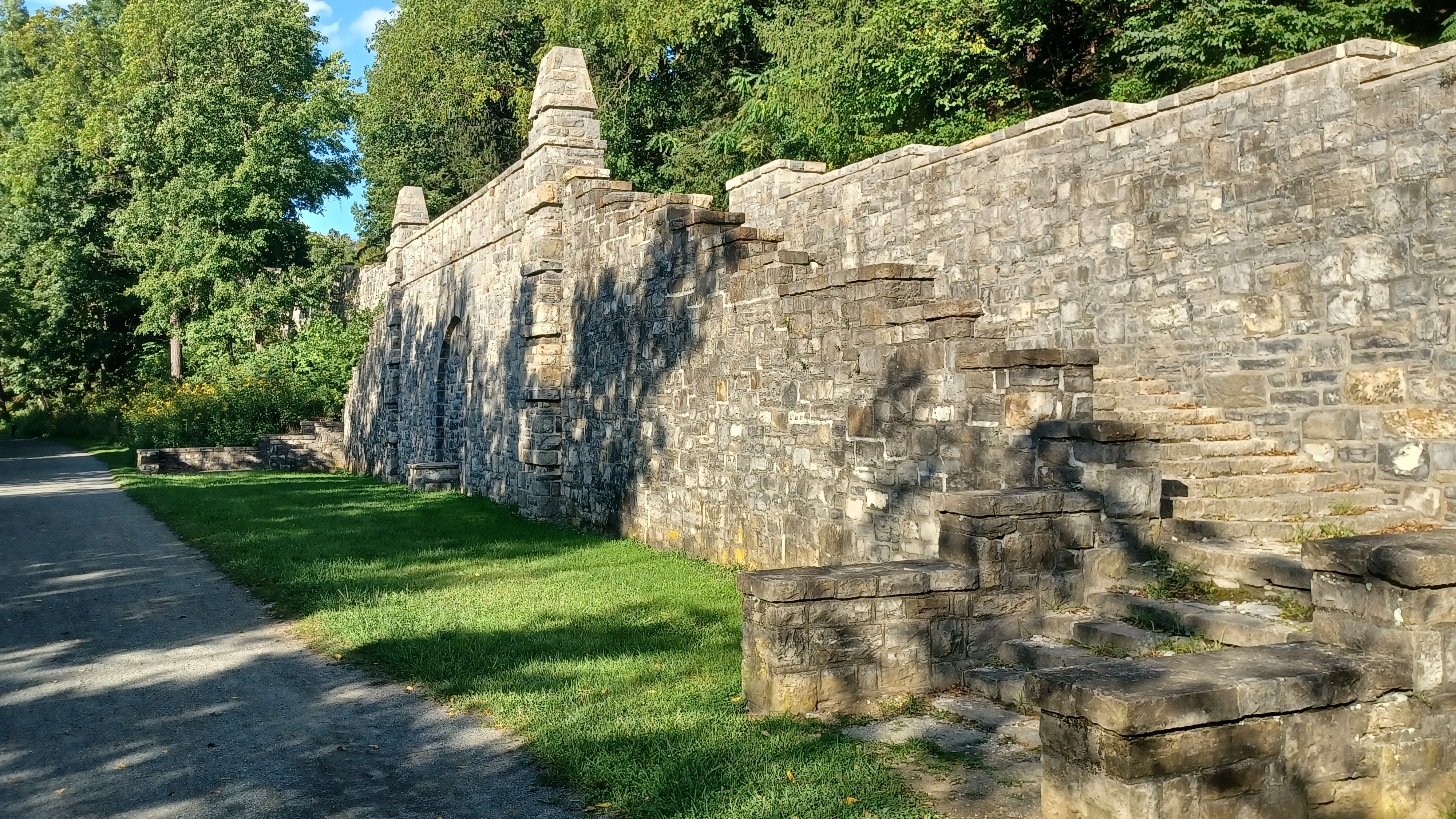
We walked along this path to a bridge over the creek for vehicles, where the Lehigh Spring is directly across. We continued straight ahead beside a grand stone structure, a 700-foot turreted wall supporting Park Drive, which ascended to the right, constructed as a Works Progress Administration job between 1936 and 1940. It was quite an impressive structure.

I think a couple of the others turned uphill on this road to try to cut a corner in the parkway for a shortcut to the end. True, the trail and creek do cut over to the west slightly, and then back to the east, but that to me is far easier than going uphill as much as was necessary to go this "shortcut".
We checked out the wall structure, and then continued on through pleasant woods ahead. There was a good, deeper spot in the creek below us to the left, and I stopped and took another dip to cool off.

Ev was out of the stroller and running like crazy. There were different sort of blocks and such along the trail, and then manhole covers for buried utilities, and every time I thought he was ready to get back in the stroller, he wanted to run to stand on top of the next of the covers. Some of the time, he went back in the stroller and then wanted to get right back out to stand on the next one.
To the right, there was also an odd stone structure, which looked like a lime kiln, but had a perfect regular human doorway in the front of it. I tried looking up what this might have been, and I found another photo of it, but I could not find anything on what it was.

Soon, we came out to Lehigh Parkway East. At this point, we had to leave the improved surface trail and turn right on the road, which required going uphill slightly, and then back down to the creek again. At this point, the Cedar Creek comes in from the left to join the creek.
We continued past an apartment complex called Terrain on the Parkway on a section of old concrete road section that dates back to 1930. These poured concrete roads have great longevity.

As we leveled out before reaching the creek again, we crossed the former Barber Branch of the Lehigh Valley Railroad, long abandoned now. This reportedly served the Barber Quarry further up the Cedar Creek. I'd tried to hike most of this at some point. I found out later that Dan tried to turn right and follow this rather than the way the rest of us went, and found it to be not a good way.
When I walked that branch, it was pretty clear to the east, but it didn't look so good anymore.
We crossed Little Lehigh Creek on Lehigh Parkway, across a very nice triple stone arch bridge to reach Martin Luther King Jr. Drive. I'm not sure any of the history of this bridge. I assume it is very old, but no one seems to have any information on it. The history of it when googled doesn't really come up with anything.

We turned right on MLK, and passed the recycling center and such. There was a weird sort of tree sculpture to the left, which Steven McNally tells me is Phil Berman sculpture donated to the city, but that this donation was made specifically to make the tax write offs. He reportedly owned the previously mentioned Hess's stores after Max Hess sold it.
Just a little further ahead, we passed by the Allentown Waterworks building on the right, which was built in 1928.

When we got parallel with Jefferson Street, there were several old buildings on the left which apparently date to around 1900. McNally mentions that these were part of a brewery.
We continued ahead, and Fountain Park was on the right. This one is a large ball field area, and we had to skirt the first section on the sidewalk, then could cut down into it and out to 10th Street.
To the left, the 10th Street Staircase ascended the steep slope to the neighborhoods above. It was built as a WPA project in 1936.

The entire area was jam packed with people, hundreds of them. Music was playing, sports were being played, and drink was being had. We got to 10th, crossed at an angle to the right, and continued through the grassy lands parallel with the Little Lehigh again.
I was so impressed at how tidy all of these park areas were. It was a wonderful experience that really showed that the people here really cared about the park.
I walked among the people, and saw many down bathing in the stream, many sitting in chairs. They had their drinks, and I had mine. I tipped mine up in respectful greeting as I walked by with a smile and they gestured in kind.

All of these people were Spanish speaking, and that culture gets a bad reputation for leaving behind a whole lot of trash, especially in the parks in New Jersey, but these folks were nothing like that. It goes to show that it's absolutely not a race thing, but a culture thing, and hits it home that not all culture is good.
The people we were seeing are probably second generation Allentown residents, who have come to appreciate these lands as I have, and they leave it better than they found it.
This impression I got did not end with this spot. As I moved further ahead, around some of the ball courts to where the paved trail began to parallel MLK Drive, there was still no trash at all. Maybe a cigarette butt here or there, an occasional bag, but almost nothing.
Also, there were no park employees or even police coming by to keep people in line, or to clean up the messes. They probably have a good force of police and labor, but apparently that job has been done to the degree that there is a mutual respect as well.

I walked on along the trail, past yet another Berman art piece, this one made of a sort of mangled steel stuff. I continued on along the paths and Delotto and I got back together in this area. I commented to him about how the culture of this area was so tidy and the park was so well kept.
We passed beneath the Albertus L Meyers Bridge, another handsome arched viaduct. Beyond here, we simply paralleled the road for a bit.
Along the way, we came across a very new concrete bridge over the Little Lehigh to the right, which was previously the route of a railroad bridge. The wrecked old bridge we walked across on past hikes.
I noticed on it that some of the original abutment construction was still there beneath the new concrete footings, but bearing no weight.
We continued ahead to the parking area and everyone else started showing up. I had a look around at one of the old railroad bridges close by. The Central Railroad of New Jersey used to come through to its station in Allentown, and the Lehigh Valley Railroad was a little east. I think the abandoned bridge we saw was part of the Barber Branch again.
It was suggested that the others go back and get the cars, and I could hang out with Ev and get picked up pretty soon. Everyone but Ev and I piled into their cars, and I decided to turn back and catch up with Dan, because he was the only one not there yet.
We walked down the trail a bit, and soon approached Dan. Together, we took a break at the new concrete bridge and had a look around for other old rail remnants, and signs of what might be the future of this area. I'm not sure if it will be a park or developed over as some sort of residences.
Eventually, we cut back to the end, and arrived just in time for the cars to return to scoop us up.
We apparently ended up doing 16.5 miles, and it ended up being overall pretty great despite the start with adversity.
I got back home, no one was awake. I got the stroller and car seat installed again without being noticed at all, and when I got in the house, my missing car keys were sitting prominently, in plain sight on my desk. I just let it all go and that was the end of it. The day could not have come to a better close up to that point.
No comments:
Post a Comment