

Hike #1622: 9/8/24 Frances Slocum State Park to Forty Fort with Kirk Rohn, Diane Reider, Sarah Jones, Jack Lowry, Brittany Weider, Justin Gurbisz, Robin Deitz, Professor John DiFiore, Sue Bennett, Chris "Cupcake" Kroschinski, Timothy Kovich, Russ Nelson, Ewa Nelson, and Everen

This next hike would be a point to point up in the coal country of Pennsylvania again, this time bringing us back to the Back Mountain vicinity for the first time in about a decade.
Even though we were into September, it's still been hot, and having considerations for swimming is still a thing for me until early October, typically.
So, the first consideration for the next hike was that it have some sort of swimming spot along the way (in addition to the fact that it must connect with a previous hike of mine).

I looked over some of the state parks in the region that we had not yet exhausted the trail systems on, and started giving a closer look to Francis Slocum State Park. I had never been to this park at all. I had the maps of it, but it was always so disconnected to the other area parks and trails that it slipped on by when I hiked much of the other stuff in the vicinity.

This time, I looked over the trail system, and then checked out all of the opportunities for hiking from it to other places I'd already done. To the south, there were some power lines and pathways, possibly some passable state game lands, and to the west was the Back Mountain Trail, formerly the Bowmans Creek Branch of the Lehigh Valley Railroad, which had been the subject of a whole series of my hikes in the past.

I had walked this entire branch from the town of Luzerne north, as close as possible anyway, through Harvey's Lake, Noxen, near Ricketts Glen, and then up to the town of Lopez, as well as additional side trails and public lands, and the Thornhurst Branch that broke off of it to a tannery.

This was the subject of a whopping six day hikes. However, I was still missing part of the right of way between Luzerne and the Susquehanna River. The branch broke off of one of the main lines along the Susquehanna at Port Bowkley Junction, then crossed over the river to Forty Fort.
I decided on a route that would feature many of the trails, as many as I could milk into one trip, then back roads and potentially some other oddities, out to the Bowmans Creek Branch, and then we'd trace that branch to the south, to a Medical Services building off of Welles Street in Forty Fort, where the parking lot is built on the rail grade.

The meeting point I'd planned was on the east side of Welles, in a corner of the parking lot that would be easy to get to. We'd shuttle from there to the starting point up on the Back Mountain at Francis Slocum State Park.

Our starting point was on Carverton Road, at the Carverton Boat Launch on the Francis Slocum Lake. It was a pleasant spot to start out, and provided direct access into the park.
I wasn't sure how well it would play out, because this was going to require us crossing the main dam, and I didn't know if there was a pedestrian route over the top of it. Fortunately, there was.
There were maps in the map box at the start, and rather than refer to the small one I'd saved to my phone, I started looking over this one.

During the course of this trip, I started looking through the history of the park and why it was so named, and I was blown away at what I was reading. How could I have never heard this story?

The park is named for a 5 year old Quaker girl, one of ten children of Jonathan Slocum. Young Frances was abducted by the Lenape from her home in Wilkes-Barre in November of 1778, and spent her first night away in a rock shelter along Abrahams Creek, likely one in a peninsula section in the park. She tried to escape but was recaptured.
As the tribe was forced further west, she traveled and spent the rest of her life with them.
The brothers of Frances Slocum never gave up looking, and 59 years after her abduction, she was found living on a reservation in Indiana. She shared correspondence with her brothers.

She was given the name "Maconaqua", or "Little Bear", and lived out her life with the tribe, marrying twice and bearing four children. She died in 1847 at the age of 74.

Frances Slocum Lake was created as part of a flood control project in 1968, and the public facilities associated with the park reportedly opened that year.
To start the hike, we headed east through the lot, and then across a swath of grass. We headed onto the earthen portion of the main dam to the north, and then crossed the foot bridge over the outflow spillway. I think the foot bridge over all of this was new, because Google maps doesn't seem to show any bridge over this at all. I was prepared to go down and have to ford the stream below somewhere, but it wasn't necessary.

On the other side, the campground road along the waterfront looped around with another boat launch to the left. We continued past that and followed the road to the north.

My plan this time was to basically try to follow the perimeter of the reservoir on the north side, which including the peninsula section should be a substantial distance.
It was a lovely view most the entire time along the road. I wanted to turn off into the campgrounds to the right a bit, but we didn't quite know what to expect, so we played it safe. We stayed on the road to the north side of the lake inlet, where there was a sloppy section to the north of the road, which crossed on a causeway, with turtles in in.

We continued around the corner, and soon there was a trail that broke off to the left, and continued along the shore into the park. This was the Lake Shore Trail.

The trail was very pleasant and easy, and seemed to follow a former road route that just happened to be barely above the level of the water.
The trail led through woods and out to an open, grassy area, then onward to a boat launching area, a short distance from the park office building where the swimming pool is open in season.
We didn't go to any of these places, and just stayed along the shore through the grass heading south. At the end of the pavement and grass, we continued straight into the woods on the same trail.

It was still pretty easy at first, right along the shore of the lake on gentle surface that I didn't have much trouble with the stroller on. There were some old stone walls from former pastures along the hills.

All of this changed when we got to near the southern tip of the peninsula section of the lake. Here, the trail turned hard to the right, and whatever old road bed we had been walking disappeared into the water.
I looked over the 1876 atlas maps of this area, and found that the first section of the old road bed the trail followed to the north was part of the Wheeler Farm. The southern portion of this toward the peninsula was shown as the land of M. Montanye, although I may have the spelling wrong. The scribe on the maps is rather difficult to read in places.

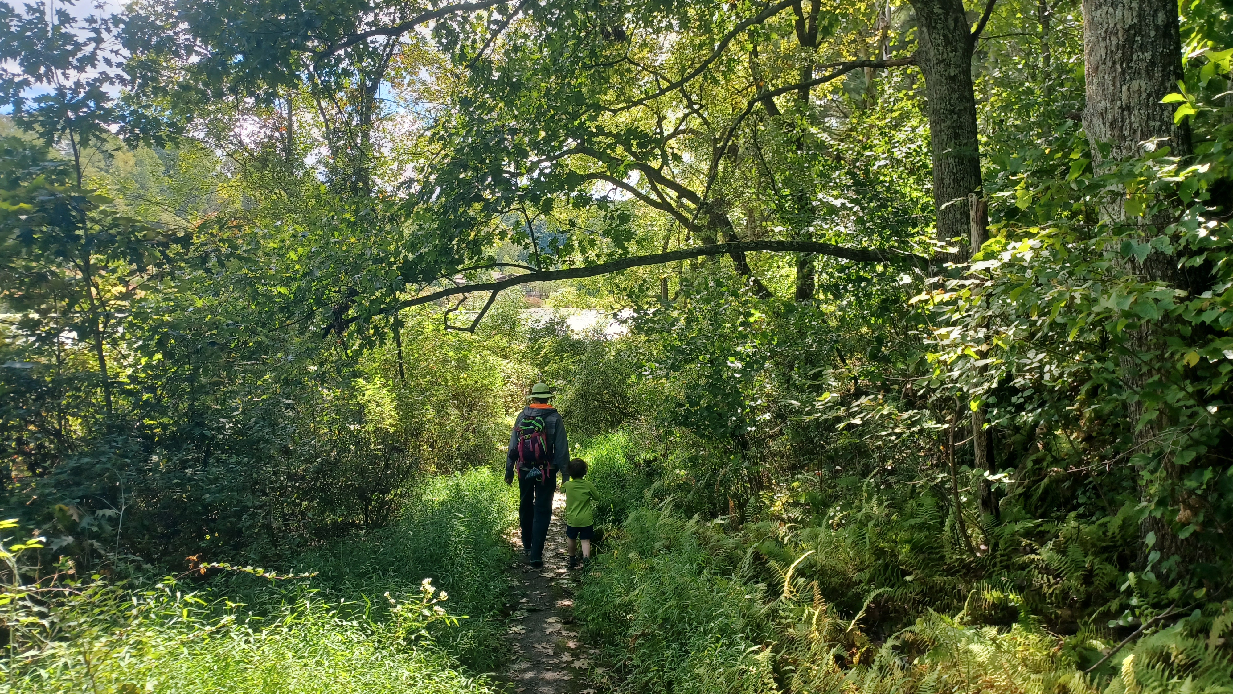
At the bend, we continued north along the water on Frances Slocum Trail. This trail was rather confusing because it seemed to branch off in three different directions, all with the same color blazes.

This part required a bit more help with the stroller to go over some of the rough bits. Fortunately, Ev was out and walking ahead with Brittany and some of the others.
I was able to get over some of the stuff with it being lighter, but others required a lift.
It was said that somewhere in this vicinity was believed to be the rock shelter that Frances Slocum was kept in the first night after kidnapping, and where she tried to escape but was quickly caught.

The group sort of unintentionally split up in this area; some of us went the upper trail, and that leads to the famous rock overhang that most people photograph as having been the one.

However, we continued on a lower route, and just off of the trail on an informal path, we came upon another rock overhang. While it wasn't as tall and impressive as the one above (at least from the photos I have seen of it), it did provide for better cover during times of inclement weather, so I think the one we found is more likely to be the one.
Ev wanted to get back in the stroller, and so I had to get some more help to get back through the next bit. I didn't see any more trail blazes for a bit, but the trail was pretty well worn.

We continued on to the north at this point, and the trail got to be more well trod. It passed by some nice rock outcrops above the lake, and eventually came out to a nice spot of grass again.

We came out to another parking area, close to the Patrick J. Solano Environnmental Center. There were good views out along the waterfront as we continued north toward the center.
There is a nature center drive that goes across the peninsula of the lake from east to west, and this was originally part of a through road, which went from Mt Olivet Road to the north, down to Carverton Road, just about where we started to the south.
I would figure this out later when we'd walk a section of that road. At this point, we continued north through the grass, and then to the nature center. it was closed, so we went around the building to the right.

Behind the building, there were very pleasant, mowed trails off into more of the park. The main one was known as Deer Trail. We continued north.

The field paths eventually gave way to more woods, which were also quite pleasant. There were a lot of tree roots that made it a bit harder to push the stroller, but I managed.

The route took across a small tributary of the Abraham's Creek, and meandered in the wide, flat flood plain. This creek was the one we had crossed much farther down on the old Lackawanna Bloomsburg Branch back in the spring.
These woods also had an enormous Eastern White Pine, one of the largest of the species I've ever seen. Brittany climbed up into the crook of the monster as we regrouped.
We continued through the woods, and then reached the main Abraham's Creek, which had a good foot bridge across it. We made our way to the other side, and then soon emerged on the long abandoned and still paved road that used to go where the reservoir is.

We turned to the left and followed the old road to the south.

The road came to a finger of the northern part of the reservoir, where it becomes submerged, but there were interesting concrete cylinders placed for a long distance across the expanse that allowed for us to continue walking. This was a really cool section.
We had seen these types of things before on many other hikes, such as on Cherry Creek Trail at Delaware Water Gap and the Upper Mt Bethel Trail, but this was the longest span I'd ever seen these things used.

Ev was very interested in all of this, and he got out of the stroller to walk across on all of them, hopping from block to block with the help of the group.

I was actually able to get the stroller across all of these, carefully. I had to lift the front end and get the front wheel onto the next of each block, and then lift the remainder over. Each block was just barely large enough that it fit the stroller on it.

After the cylinders, we passed another very impressive, giant white pine, and then beyond that, a Mayhaw tree, which had fruits ready to consume.
I stopped and pointed it out to everyone so that they could try them. The Mayhaw bears a fruit in that resembles a cherry or Cranberry, but tastes like a tart apple.
It is uncommon to find such a tree so far north as the northern coal country of Pennsylvania, as their regular habitat is southern United States.

The species of Hawthorn is known for making good jams, jellies, and wines.

We continued along the abandoned road to the south for a little while more, until the Deer Trail turned off to the right, just before the pavement dipped into the waters of the reservoir.
This was the roughest section of the trail system for me to walk. It was much more rocky, and not terribly well marked. At one point, we even ended up going off the trail for a bit, and had to find our way back to it.
Some of the trail was a pretty narrow foot path, right on the water's edge. Fortunately, Ev was happy to walk much of this, because it would have been much harder otherwise.

Ev did particularly great, and ran much of these trail sections happily. The trail shifted from Deer Trail to Maconaqua Trail, of course named for Frances Slocum's Lenape name.

There were a few more stone walls and such as we made our way to the south side of the park.
Soon, we reached the parking area on Carverton Road, which ended our time in Frances Slocum State Park. I was very glad that we'd done this park, because it was really quite beautiful. I'll have to do another in the future where we cover some of the other trails and find connections to other places.
We turned to the right after a break, onto Carverton Road heading west. This was a crummy road walk, but after all of the struggle getting the stroller through the last section of the state park, I was quite happy to be pushing the stroller over easier stuff.
It was only about a mile we had to follow of this road, so it wasn't all that bad.
There was a nice view along the road of the Back Mountain to our left, the south, as w econtinued east. My plan was to follow this to a lunch stop at one of the places at the next intersection in Lehman Township.

We soon passed by TC Riley's Pub, but that one was closed at this point. There was an "adults at play" sign outside, but we had to continue on.

There was a little side gravel road with extra parking that went from this bar parallel with Carverton Road, and then down into the parking lot for the Checkerboard Inn, which was open. This would be our lunch stop.
We got to the front of the place, and I went in ahead of everyone to see what our options were for seating. They obviously had a very nice outdoor area, which is a sort of roofed pavilion but in the open air, with almost no one in it. I asked if we could eat out there, and they said absolutely.

We all went to the outdoor area, and found a good seat out at the corner of the place, and it was just perfect. I could let Ev out to run around a bit there, and we could be our loud selves without having to bother anyone else.

This was one of those lunch stops that left me insanely stuffed. I ordered a pasta dish, a fettucine alfredo with broccoli, because we'd had some recently and I wanted more of it. Ev ate some of that, but then everyone had something of interest to share with him.
Ev ended up having pizza, some sort of other stuff I don't remember, fries, and other healthy stuff too. I ended up eating a lot of leftovers from the rest of the group as well, so I felt pregnant man fat.
While we were there eating, Russ and Ewa showed up and hung out for a bit. We were planning to meet them when we got to the railroad bed, but we were a bit behind schedule, but not by much.

They had one good thing in the draft menu that was of interest to me, but it was taken off, so I had to get another IPA thing that wasn't bad. It seems all of the good strong stouts and such are all disappearing lately.
When we were all finished eating, we headed out. Russ and Ewa headed back to Trucksville area to get on the rail grade ahead of us, and we'd connect with them when we reached the bottom.
My plan here was a bit oddball, and I didn't know if it was going to work, but we were going to try.

We could have just walked the Carverton Road downhill to the west and gotten on the railroad grade, but I didn't want to do it that way.

At the intersection, Dug Road went south, and Manor Drive went north. We crossed ths intersection, and then turned to the right through the grass parallel with the Sunoco Station.
We headed rather steeply uphill, and then entered the parking lot for the Cross Creek Community Church. I'm not sure if this was the settlement of Cross Creek, but it certainly should have a name. I am just not sure of it.

There was a power line clearing going out of the church vicinity, but it didn't look too inviting, and a gravel road called Country Drive which went out to Manor Drive, but that didn't go really where I wanted to either.

I turned around from that road, back through the church lot, and started heading uphill through the church property. I figured we'd cut through the trees and such and get to the Rock Recreation Center.

As we went up the hill and skirted the wood line, there were mowed cut outs into what looked like they might be connections to the rec center, but all of them dead ended at fallen trees. Maybe at one time, one of them might have gone through to somewhere, but they certainly didn't now.
We had to keep backtracking through all of this stuff, right up until we hit the top of the hill. Just then, Cupcake came up to us and said we could get through. Not where we were walking, but on another side path that was down closer to the connection to Country Lane. He said he'd gone in and they talked to a guy doing chainsaw work out there.

It was apparently a local guy who was just opening up a trail, which went from the church area to the abandoned Roc Rec Center Tennis and Swim Club property.

We headed back downhill, and cut into this trail into the woods, which was quite pleasant.
The trail took us downhill, over a sort of wash, and then up gradually along a slight slope. This brought us out in a corner below some ball courts.
The entire area was overgrown with high grasses. There were a couple of abandoned buildings with doors wide open. I didn't bother going over to that, but some of the others went over to look inside. I didn't want to have any trouble. Certainly, someone had told Cupcake that we could go through, but I didn't want to overstay the welcome.

We headed to the west a bit, into a large, paved parking area and continued onward.

Pretty soon, we came out to Harris Hill Road. We waited for a little bit here for the others to come back out, and then turned left to begin heading down the hill to the west.
The area was lightly residential as we continued on near Shavertown. Sometimes it was a little rough with a limited shoulder, but Harris Hill Road is closed further down, so it has more limited traffic than it would have had otherwise.
We passed by one house where a guy asked us if we had gotten through alright. It turned out he was the guy doing the chainsaw work to open up the trail further back.

We continued on, and came to a point as we approached Trucksville, where Harris Hill Road is closed ahead. This is because the old arch bridge that crosses the Toby Creek is apparently unsafe.

This is an interesting spot. It is where we met up with the Back Mountain Trail, former Bowmans Creek Branch of the Lehigh Valley Railroad, but also an old trolley bed.
The Harris Hill Road culvert actually is the old trolley underpass. When adjacent Rt 309 was widened, it required moving Toby Creek along with it. The creek was routed into the trolley cut and underpass, and then down a slide falls to its original course. This had been one of our fun stops the previous time I hiked Back Mountain Trail.

Russ met up with us at the former railroad crossing, which was very obvious on the right, north, but not on the left.

Although Harris Hill Road bridge was closed to traffic, it was still easy to walk right across.

The Back Mountain Trail must leave the railroad bed at this location, cross the bridge, and then turn left parallel with Rt 309 for a time, descending gradually.
Originally, there was a double stone culvert that carried Harris Hill Road over the creek, and another one that was apparently added later on the east side for the trolley, and that is the only component remaining of what was once a three span structure.
It is in this area that there is a side path down to the edge of the Toby Creek and the slide waterfall.


My friend Lerch slid down this first when we were here over a decade prior, and since it was a reasonably hot day, I planned on sliding down it again today. We got to the spot, and I turned to the left on the side path to check it out.


I climbed to the top, and it looked a little sketchy to do without testing it. I then went to the bottom and stood in the pool to see just how deep it was and if I could pull it off.

I figured I could do it, and so I went back to the top and slide down the thing, which was a little unnerving. When I hit the pool at the bottom, my feet hit a lip in the rock, which hurt, and shot my knees toward my face. It was rather painful, but not terrible. I wouldn't be trying that again until I knew there was a greater volume of water going over all of it.
I was still very glad I went in, because it was so refreshing. I climbed back up to the trail, and noticed that there was a very old mill wheel stuck in the slope there. Not sure where it came from, but it was cool. We continued on along the trail to the south a bit, and came closer to Rt 309.


Soon, we came to the crossing of the intersection of Carverton Road. At this intersection was a former trolley station and stop, and there was a tall wooden trestle that carried the Bowmans Creek Branch over top of the road just to the east of us.

The trolley line here has a rather unique history as well. Local entrepreneur John B. Reynolds had an interesting plan for a trolley to connect from Wilkes-Barre to Harvey's Lake, but there was a problem: trolleys, unlike steam railroads, did not have the power of eminent domain to build.
Reynolds was not deterred by this, and he instead organized a company known as the Wilkes-Barre and Northern Railroad, a steam railroad, as a facade to get his trolley line built. A couple of lighter than average weight steam locomotives were even purchased for use on this line, and used to some extent in the years before it could be electrified.


The first section of the trolley line opened in 1896, which included the section that paralleled the route we were taking.

Part of the problem was the existence of the Bowmans Creek Branch of the Lehigh Valley, and one of its founders, lumber and ice magnate Albert Lewis, who owned land needed for the line.
Construction continued, including over Lewis's land, but property was destroyed by Lewis in an effort to thwart any of this construction.
The trolley through this area remained in service until about 1939. Highway expansion as well as of course dropped patronage led to the demise of the line.
I got some then and now compilations through this area as we went by, and then headed over to the Carvertown trestle site. A set of large wooden stairs lead up to the former Bowmans Creek Branch, now more of Back Mountain Trail.


This railroad here began as a 12 mile lumber line built by Albert Lewis in 1886, from Luzerne to Harvey's Lake. It was purchased and extended upon by both Lewis the Lehigh Valley Railroad starting in 1887, through 1893. That year, the Lehigh Valley Railroad took control of a 79 mile line between Wilkes-Barre and Towanda, and named it their Bowmans Creek Branch.


This was an important line because it pierces the North Mountain and Endless Mountains region. There had been no means of getting the valuable lumber from this region, much to the dismay of prominent landowner Colonel R. Bruce Ricketts, who owned enormous tracks of land in the region. Further, there were also semi-anthracite mining interests in the northern region, which warranted the construction of a railroad to serve the resource.


As time went by, the value of lumber grew stronger. The wood was needed for the continuing expansion of railroads, which required countless ties, as well as mine props for the ever expanding coal mining industry.


 |
| Jesse Brelsford Collection 1950s |
Mining and railroad expansion began to slow down nationwide. This line remained a through route until the late 1930s when the first sections were closed. The remainder of the line from Luzerne to Noxen was abandoned by the end of 1963.

Much of the line between Luzerne and Dallas is now the Back Mountain Trail, and other segments can be followed through State Game Lands to the north, but much is also private.
I needed some help to get Ev up most of the steps. The lower end of them are really steep. When we got closer to the top, I could bypass the slopes and reach the railroad bed more easily.
Ewa was already ahead of us, and waiting on the right of way ahead, which was on a high slope.

The Carverton trestle has been long gone for years. I think it was demolished in the late 60s, and caught fire multiple times before it was finally taken down.

At times, the trail barely resembled a railroad bed. Years of abandonment leads to a lot of decay of what had once been a major through route.
As we continued a bit further, we passed where Post Road came in close on the left, and then we started seeing railroad ties again. It's interesting that a well developed trail section has not seen the ties removed, but I do like it that way.
We continued on, and there was a sign off to the right, with something about a hidden bench or something.

Indeed, there was a little side path, and some handsome stone work with a bench below the trail level. I couldn't figure out why this stone that looked like a WPA project was down there at first.

It turns out, this was originally a connecting road from what is now Rt 309, up and across the tracks to Post Road, used by Hillside Realty. A nice little spot really.
We continued to the southeast further, and the right of way became like an open meadow at times. It was a really nice spot, through the deep gorge through Back Mountain toward Luzerne. Rt 309 was below us much of the time.
We continued into a more wooded setting, and then passed by an enormous metal tank, which I thought was some sort of odd water tank.

It turns out, it was used by a local dairy farm, Harter's Dairy, I suppose for milk would be obvious.

We continued ahead through an open area, and then past a small cascading stream to the left.
We weaved out and away from Rt 309, and there was a side road that went out and around to a large water tower. This was the original route of 309.
Years ago, when we hiked this before, Justin and Lerch went out over to that water tower, and Lerch lost his expensive camera. We had all been drinking quite a lot, and he left it up there. He went looking for it later, but could not find it.
This side road that goes out by the water tower is the original Rt 309, which had a more dramatic bend to it before it was rerouted and straightened.
We continued along the right of way pleasantly, and occasionally more ties were visible.
As we continued south, the rail bed remained on the shelf above the highway, and we were soon above the Luzerne Lumber Company. Some of the buildings below us at this place, as I understand, were part of a coal breaker which extended from this site below to the mountainside above the railroad bed. Along the rail bed, the only visible remnants of this once very large industry was a large stone wall along the left side, on the slope.


We continued on the shelf and eventually passed by the access point and sign off of ninety degree bend in Parry Street.

The railroad right of way is apparently obliterated in this area, and it is necessary to walk Parry Street ahead.
There was a junction right about at this point, and the main Bowmans Creek Branch turned a bit more to the east, while the trail follows down Parry and along the branch that remained closer to Toby Creek, which connected with the former West Pittston Branch of the Lehigh Valley Railroad.
We continued down Parry, then crossed Main Street. We continued directly beside the Toby Creek from here, behind buildings on a narrow route, and emerged behind the Luzerne Borough fire station, at the corner of Buckingham Street and Tener Street.
Russ had been watching the maps better than me, to see exactly where the main line used to go, and he had it figured out based on a turn it took and somewhat vacant lots on the right of way just to the east of us. We chose to head back to the north a bit, to get back to where we lost the main line.
As we walked, there was a lot that was patriotically adorned with thousands of small American flags, which looked really cool, and certainly for the Labor Day weekend.
Among the flags, there was one "Trump Vance" sign among them, and Sarah went over and kicked it down. I was not cool with that; no matter how you feel about any candidate, it doesn't give the right to enter upon someone's private property and destroy what they've placed. I went back myself and put the sign back up.


I think the railroad came across Kelly Street to the north, but there is a chain link fence that blocks off where the tracks should have been through there. We meandered a few more streets, and the only interesting thing was a toilet beside the road.

Where the railroad went, there is a slight curve in Jackson Street, and it cut slightly to the south near the intersection of Jackson and Oliver Streets. A house on the southwest corner of there has an odd angle to it, certainly because it was using the space it had without interfering with the railroad.

From Oliver Street, some of the right of way remains clear, but we didn't pass through it, just checked it out from the south side on Chestnut Street. A house appears to have been built on top of it from here.
We turned south here to follow Pear Street, which is directly beside the right of way.
In the distance to the northeast of us, there were enormous mounds of coal refuse in view. It almost looked like a sort of volcano. A former coal breaker site is reportedly in the process of being mitigated.

At the end of Pear, there was a set of stairs going down to Chapel Street. I wasn't sure if the railroad had gone over this road via a bridge or at a grade crossing.

I got help taking the stroller with Ev in it down the stairs onto Chapel, and we looked into a swath of woods on the other side.
I was rather shocked that the railroad was very obvious here. Ties were all still in place, and with a reasonable enough path beside it for us to follow!
Some of the group skipped all of this and just went for the quickest way back to the cars from here, but most of us entered the woods and began following the bed of ties to the south.


It was a little rough, and at times the right of way had washouts on it, but we managed to get through.

After a little bit, the track bed itself was getting pretty badly overgrown and washed out. We reached a very deep washout that we were not going to be able to get through with the stroller.
I do somewhat miss being able to get through most anything, with all of the considerations we have to make for the stroller, but it's still worth it.
We headed uphill to the right, and found a reasonable enough path past the washout. Some of this washout was deep and extended through the woods to the west. We got up to a point where we could get the stroller over it safely, and came out into some grass.
We were at this point on a sort of disconnected stub of Oliver Street, but in the grass just below it. We continued to the south, and soon realized this too was a rail bed. It must have been an industrial siding.
Just a little further, we passed an old gated entrance to a former steel manufacturing site. We could see rails still in place in the grass here.
I think the main Bowmans Creek Branch was actually on the opposite side of the building.


 |
| Photo by Cupcake |
We continued through this grass, and there was an old pair of overgrown steps to the right that went out to Carpenter Street.

A disused building was back there, with only its still framework remaining. We passed through this, and then found a faint path down through brush, through a dense thicket of Japanese Knotweed.
Thankfully, it wasn't too bad that I couldn't get the stroller through, but to look at it, one would think it wouldn't be possible.
The spot we took might have been exactly where the railroad bridge had been that carried the Lehigh Valley line over top of the former Bloomsburg Branch of the Lackawanna.


We continued from here into the edge of a business yard with piles of stuff, headed toward Chestnut Street, and then turned hard left onto the old Lackawanna line.


We had followed this one somewhat recently, in three hikes between the bridge that carried it over the Susquehanna River all the way to almost Berwick.

The line was built in 1856-57 as the Lackawanna and Bloomsburg Railroad. I think it was 1872 it became part of the Delaware, Lackawanna, and Western as its Bloomsburg Branch, affectionaely referred to as "The Bloom".
We followed this to the east, and passed beneath where the bridge would have been on the Lehigh Valley line. Apparently there was once a junction in this area from that line as well, from what I can see on maps and aerials. We continued on this as far as Slocum Street, which I understand used to be a station stop on The Bloom. We turned right to here, on Slocum Street, to continue.

I think just about everybody left me at this point. I wanted to go over to see more closely where the Bowmans Creek Branch went, but many just continued down Slocum Street.

I went to the west on Murray Street. I then turned left on Dilley Street to parallel the Lehigh Valley line.

A path went over to the abandonment at one point, and I ran off into the woods to see if there was anything worth getting a photo of, but it got too thick to get through. I just took the opportunity to pee.
We continued down to the large Wyoming Avenue, and I dashed with Ev across as soon as I had a clear chance. Rt 309 overpass was nearby and much traffic was coming through.
Everyone turned another way at this point. Ev and I continued down Virginia Terrace to the south, through a neighborhood with friendly waving people, and we came out to Elizabeth Street.

We turned slightly to the right, and it was obvious, right next to Rt 309, where the Lehigh Valley line came across. It was a grassy swath to the north of Elizabeth Street.

To the south, we could easily walk the right of way because it was all access road and parking lots shifting to the east.
We had been to this spot before. There is an old industrial mill building that now has a restaurant known as The Canning House in it. Obviously, this was probably a canning industry that was rail served back in the day.
We continued around the former railroad curve, to Welles Street. Across on the left, the medical facility close to where we were parked was formerly a sort of distribution center for Acme supermarkets.

This was another once rail served industry. Everyone was back to the cars to the right at Welles.

Just ahead, the railroad right of way remains at the middle section of the parking area, and a sort of dip in it at times seems to be where the tracks were.
I decided to walk all the way to the end of the lot where there were dumpsters, to dispose of my garbage from the day, but also to get a couple more shots of the bridge site. It was just a little bit beyond this point where the line crossed over the Port Bowkley Bridge and connected with a Lehigh Valley main along the Susquehanna on the other side, at a former port site on the North Branch Pennsylvania Canal.

I meandered back, and everyone was getting ready to head out. I got a ride back to my car, and was on my way home. I stopped to get a few more historic shots comparisions on the way back.
It had been really a pretty great hike, full of familiar and unfamiliar places.