Hike #1454; 11/16/21 Trenton, Morrisville, and Scudders Falls Loop with Shane Blische, Professor John DiFiore, Violet Chen, Charles Updike, Jennifer Berndt, and Everen
Just about done with my paternity time off since my son was born, I was trying to continue doing some bonus week day hikes with him while the weather was good, and there is always something going on.
On this date, there was the grand opening of the new Scudders Falls Bridge pedestrian walkway. There were to be a lot of people present including many friends through my job at NJDEP, and probably many others too.I wanted to try to attend the event because it was sort of a momentous occasion, and it meant different ways of doing different loops around the area. I figured it would be cool to be the first group to actually do a loop around that area.
Because I was doing this event with the bridge opening, and I knew hundreds of people would be there anyway, I chose to actually post the event. It didn't matter. Maybe people would show up, maybe they wouldn't. If they did, good. It would do no harm.
Shane, John, and Violet all came at the start of the loop, and Charles Updike, who had hiked with us one other time previously, on the first hike of my Neshaminy Creek series. I'm always glad when someone comes on their second hike with us, because it means the first one didn't scare them off too much. People typically do come out again after one.
We headed onto the towpath to the north, which started to move away from the Delaware right after the bridge and crossed Ferry Road.
The section ahead was quite pretty, and still had plenty of nice autumn foliage to check out. More had dropped since the past week, but was still nice.
We passed beneath the pony truss Letchworth Ave bridge, where the trusses were affixed to a newer superstructure for ambiance and do not bear any weight, then beneath College Avenue and Afton Avenue.
In New Hope, the canal is down in a cut and you can blink while driving the bridges over it and not even notice what it is. In Yardley, streets are right up against the canal. People live on the towpath. Edgewater Ave actually follows the towpath and we walk by the fronts of homes.
A lot of people would find this to be horrible because they want the nature experience, but for me, the historic and cultural aspects of these trail routes are at least as important as the natural ones.
We did get our share of nature however, as we left Yardley to the north.
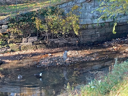
As we reached Upper Yardley, at Lock 7, we saw a Great Blue Heron stalking a couple of Mallards.
This was really interesting. I don't know that a heron would kill full grown Mallards, but I have known them to attack ducklings. There were no ducklings present while we were walking by.
The heron was certainly more used to having people around, because it did not seem too alarmed that we stood watching him for as long as we did.
From here, it wasn't much farther to the new Rt 295/Scudders Falls Bridge where we would turn off.
A new foot bridge had been constructed over the Delaware Canal at this point, and this was the first time I'd seen it open.
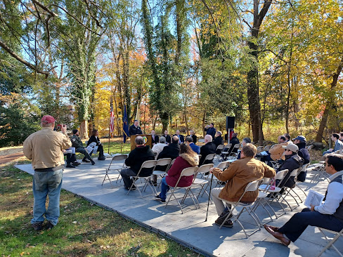
There were tons of people walking around; public, officials, mingling around several pop up tents, and chairs set up preparing for a presentation and speakers.
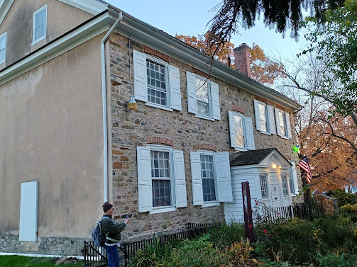
The old stone house built in 1799 was still standing along the edge of the canal. I had thought buildings would be torn down for this, but it was good to see that it not only was left in place, it was restored and repurposed.
The house was originally from the Scudder family for which the area is named.
Often, when these buildings are restored, they basically sit around doing nothing. They'll be a "museum" that is open maybe one or two days a month, and that is it.
This one is actually really cool.
The inside was redone so that it is now a dual use visitor center and restroom facility/comfort station along the trail. Old beams were exposed inside, the foundation stabilized, and stone facade repointed. I believe a twentieth century addition was removed from the building.
I pushed my way in, and I realized I had an empty bottle of Tiny Belgian style imperial stout in the stroller that I had to dispose of quickly before some of the officials noticed it!
As I mingled, the first person I recall recognizing was Jimmy Douglas from the NJ Trenton staff who handles social media stuff. I talked to him briefly, and then moved on through the crowd and came upon Patricia Kesseler, Superintendent of D&R Canal State Park, and Mark Texel, state park Assistant Director.I stopped and talked to them for a while.
Patricia had filled in as Superintendent where I work for almost a year, so we got to know each other a lot better, and I really love her leadership style and demeanor. I always liked her from the first time I met her, but having her as a boss really brought my appreciation to a greater level.
When I told her that I was going to be a father, she and my previous Superintendent Jenny were both supportive and helpful with advice and stuff that we could use when the baby came.
Now that I'm a dad, something has changed with a lot of people, where I'm in this sort of "parents club". So many friends and coworkers I had been close to for years were already ahead of me having children, and I had thought that ship had sailed for me until it happened.Now, all of a sudden, so many friends and I are exchanging kid photos with one another of the things we're proud of and are bringing us joy. Patricia was the first of those to really welcome me to the parents club, and we still exchange happy text messages of the stuff our kids are doing.As soon as Patricia saw me, she immediately wanted to hold Ev. He was practically asleep when I walked up with him to the event, but he had never minded being held. As time as gone by, I can appreciate how the passage of time and the growth of children can leave a void and holding another baby can reconnect to a past time. I kind of see that when I see other parent friends hold my child.
I have found that being a father, having a baby, really isn't difficult at all. It is just constant. It never stops, and it always changes. With these changes come some feelings of missing out on the way things were for a brief time.
When Ev would sleep for a long time, that was nice and easy, for example. When he was so light that carrying him was like basically carrying nothing.I always watch people and read how they are absorbing their experiences, and it is very apparent that each of these moments are important ones that I have to enjoy to their fullest while I can.
I'm obviously way behind on writing journal entries for the hikes, simply because I only do it while the baby is asleep, during a nap or after he goes to bed, when I need to rest my body but not my mind.
With Ev, I held him seconds after he was born. It might have been more shocking than it was amazing for me. I cut his umbilical chord myself, which was one of the thickest the doctors had ever seen.
I had this horrible fear of holding him wrong and accidentally snapping his neck.But then it got easier. He got stronger, and I could have him on my lap as I typed on the computer. I could place him down with a bottle within sight and everything was okay. By the time I could bring him hiking, those fears were going away. It felt most better when he started turning his head and looking around on his own.
By the time he came on his first hike with me, he was already reacting to me with smiles. Genuine smiles that were a result of my actions and attention. I had been told that wouldn't happen until much later than it did, and it made appreciating him so much better.
The moment I saw Patricia holding Ev, I understood the "parent club" thing more. In the future, I knew I would be in the same position I was seeing her in, because I have a frame of reference.
That frame of reference is something I've brought up with the hikes for years. We build upon our memories and appreciate that which we have a frame of reference for.
Having Ev with me while I'm doing these hikes has enriched them so much more, and strengthened my bond with him beyond measure.
I can't do a hike without him any more without freaking out thinking I'd forgotten him in his stroller somewhere.
I told Patricia that I wanted Ev to be the youngest one across the new walkway when it opened, and to be the first stroller over the multi use route. I got to chat with Mark a bit too about trees and how I thought we needed to adopt a policy of thirty second rule. We don't in the state have any particular policy on how to handle hazard trees by priority. It has been my feeling since working for Hunterdon Parks that we should look at these trees as a hazard if it is someplace we might stop for more than thirty seconds. That could be a bench, an overlook, a camp site, a grill, a sign, or various other things. He seemed to agree on that, but I don't think any policy has been adopted yet.
After a bit more mingling and seeing other friends, we were called out to be seated for the start of the presentation. I remained off the sidelines rather than sit down because I had the stroller. Ev fell asleep because I gave him a bottle just before it. He didn't stay asleep the entire time, but when he started shouting I took him out and walked around with him to comfort him.
Shane and John stood with me and the others mingled around I think a bit more for the presentation.
The Color Guard was called out next and we did the Pledge of Allegiance. Reporters were recording.
I'm sure Ev and I ended up on the news somewhere there, but I never saw any of it and I actually still haven't bothered looking it up yet.
There were different speakers through the course of this. The Mayors of either municipality, either side of the river were among them. I think there were other local representatives I can't quite remember.
A man spoke on behalf of Delaware Canal State Park, and on behalf of New Jersey parks, John Cecil.
I had met Mr. Cecil once before at Spruce Run and had a nice talk with him, but I didn't get around to talking to him while I was there this time.
Mr. Donnelly from the Delaware River Joint Toll Bridge Commission and others were also up there, and I regret not having had the opportunity to meet him at this time.
Mr. Donnelly follows the Metrotrails facebook page and leaves excellent commentary on historical points with regard to the bridges, so I do want to meet him.
Some talk was made on the 1799 house, and there was a cover over the front of it.
A small piece of the predecessor bridge at Scudders Falls was placed on a piece of concrete in front.
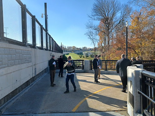
Once cut, the public moved up the ramp onto the bridge. John, Shane, and I were up front and I stuck kind of close to Mark and Patricia going across and taking in the view.
The ramp was a long bridge over a wetland, which I think is part of a wetland restoration project there, and then turned left onto the multi use walkway. This was one of the widest walkways on a bridge I've seen.
One of the points that was brought up about this walkway was that unlike other bridges, it was not one where they had signs to dismount bikes. The width allows public to legally remain on the bikes.
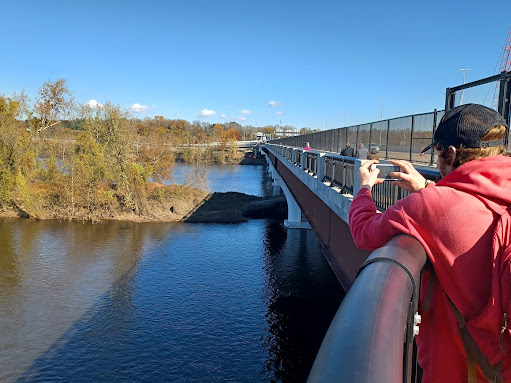
There were good views going over the bridge. Scudders Falls itself isn't really a waterfall, but rather a riffle of rapids in the river where it drops several feet in a short time. There is a big island in the river just downstream from this drop off.I chatted a bit more with Mark and Patricia going across. Shane got a chance to finally meet Patricia too, which is good because of his expertise on the Bel Del Railroad, and the fact that so much of the signage both along the trail and on local roads have incorrect dates and information on them. He really wants to be a part of the re-writing of these with the correct information.
We continued to the other side, and the walkway turned to the north to head down and connect with the old Bel Del Railroad grade, beside the Delaware and Raritan Feeder Canal.
The canal here was built in 1834 to provide water to the main canal, which went from New Brunswick to Trenton, then down to Bordentown. It would supplement the water level in the canal, but also provide a freight route to the north as far as Bulls Island in Raven Rock NJ.The Belvidere Delaware Railroad was built in 1850, and much of the original towpath was used as the track bed. At that time, the towpath was switched to the east side of the canal.
The public erroneously refers to the Bel Del rail grade as the "towpath", when in fact the rail bed was only the towpath for some twenty years, and it never went further north than Bulls Island.
The trail continues north from Bulls Island to Frenchtown, but from there on up it is strictly railroad. There was never a canal on the New Jersey side until the Morris Canal for a brief time in Phillipsburg.
When we got to the New Jersey side, Patricia and Mark and others got to the bottom, and then turned back on the other side. The Metrotrails crew turned to the right at the bottom of the ramp to start heading south on the NJ side.I found out after a bit that there were people looking for me on the other side of the bridge when they expected me to be coming back. One of them was Mr. Donnelly, and not sure who else.
We made our way along the trail beneath the bridge, and there was still some construction equipment around the area. They must have had some more work to button up.
We soon crossed Upper Ferry Road, followed soon by Wilburtha Road.
There is an abandoned house at the road crossing which served as offices for a quarry operation.
Shane told me that there was a large abandoned earth mover still back in the woods among all of the trash, so I wanted to get a look at that.
He led me through the woods and out to the thing, which looked like an old style drag line.
Jen met up with this at one of these crossings to continue the rest of the hike with us.
There was a long pleasant section ahead with a more wooded feel, and we passed beneath the former Reading Railroad which crosses over the Delaware nearby.
This was the section that was built as the National Railroad under Delaware and Bound Brook Railroad to compete with the Pennsylvania Railroad controlled Mercer and Somerset line, which didn't even last a decade of service.
We continued on across Lower Ferry Road and parallel with the Trenton Country Club. Beyond that there were some abandoned buildings across that canal that were once a part of a hospital complex. We soon crossed Sullivan Way on an aqueduct structure, probably built around 1910.
Pretty soon, we started to approach the property of Cadwalader Park, on the opposite side of the canal from where we were walking.
This land was previously the farm of Thomas M. Cadwalader, who sold a strip of his land for development of the canal in the 1830s.
He retained rights to have a bridge to access his farm lands on the other side by way of a bridge that swung when canal boats would go by.
In 1841, the 148 acre property was purchased by Henry McCall, who constructed his mansion above the canal. He had a tree lined access road known as Lovers Lane and a bridge went across the canal to access that property.
The McCall property was sold to the City of Trenton for the development of Cadwalader Park in 1888. Hundreds of trees were planted here to block the view of the bus transportation corridor of both the canal and adjacent Belvidere Delaware Railroad.
Despite the efforts to keep these things separate, the draw of the canal was unavoidable, and the canal and rail line were well utilized by park patrons. A dock was even installed on the canal.
Further, the Bel Del/Pennsylvania Railroad began operating a station stop for Cadwalader Park in 1903.
The railroad was torn up in the 1980s.
We made a little stop at the park and walked across the bridge. I think I gave Ev another diaper change here like I did the last time we went through because there was an easy table area to do it on.
Just after the park, we passed over the Parkside Ave Tunnel, which is a concrete bridge installed in 1910 to carry both the railroad and canal in aqueduct style over the road of the same name.
We continued to the east from here and crossed over Hermitage Ave along the canal, and then a short distance beyond that point, reached the point where the Bel Del Railroad bed continued into Trenton to the left, and the old Delaware and Raritan Canal continued off to the right heading into the lower portion of town.We had done a good amount of the canal on the previous visit, so this time we continued on the old Bel Del line to the east.
We passed beneath Prospect Street in a cut pretty soon, followed then by Calhoun Street. We then reached an at-grade area where Belvidere Street was to the left of us, and Summer Street was to the right.
We crossed Fowler Street followed soon after by Willow Street, and then came back to the edge of the Delaware and Raritan Feeder Canal.
The railroad again rain alongside the canal in this section.
Just ahead, we reached the crossing of both the north and southbound lanes of the Lincoln Highway.
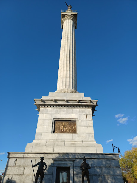
We had gone to the south side of the canal, and we crossed back to the north side and then walked up the park median between the two lanes of Rt 206, a short distance away to what was known as the "Five Points", and the location of the Trenton Battle Monument.
The battle, along with battles at Princeton and Monmouth, considered to be turning points of the American Revolution.
The hollow, granite Roman-Doric fluted column structure on pedestal was designed by John H. Duncan, architect of Grant's Tomb, and modeled after "The Monument", a 1671 structure in London England built to commemorate The Great Fire of London that happened in 1666.
The top of the monument is adorned with a statue of George Washington, depicted at the start of the battle.
An electric elevator inside took visitors to a platform overlooking the city in the area of the battle. Unfortunately, the elevator is no longer in operation today.
The monument was dedicated October 19th, 1893.
The monument is actually under management of Washington's Crossing State Park, and I had to head down there for work at some point before.
We continued back to the rail bed and continued to the east from here.
The trail now skirts the former railroad yard to the east for a bit and requires only about a block of road walking to get under the highway in one section.
We weren't going that way this time, though. This time, we would be heading south where the main Delaware and Raritan Canal used to go. This fork in the trail we had reached used to be the connection point. The main canal is now obliterated, built over by Route 1.
It was about ten blocks to the south on Stockton Street where we came to a trail along the Assunpink Creek to the right, which continued into Mill Hill Park.
Charles led us from the creek side up to South Montgomery Street to a very nice statue of George Washington in a square that I had no idea existed. It was all part of a very nice historic district.
William Trent took over the land and mills in 1714, and it became known as Trent's Mills.
A paper mill was also constructed on the site until it burned down in 1872.
They were basically dismantling the building from the outside, chewing away at it slowly until it was nothing more than a pile of rubble. It was really interesting to see it coming apart.
As soon as we got out there, there was a guard that frantically came up to us, telling us we couldn't be there. I engaged with him dismissively stating the fact that there were no signs saying to stay away from that area of the building, nor was there any caution tape. He angrily noted that someone keeps knocking it down.
There was indeed caution tape on the south side, heading west, but going around that bit led out to where public was allowed to be again, so we got to go that way. I let the guy know that there was no tape like that on the other side either, and that he might want to go over there and put some up or there will very likely be more people coming around in the same way that we had just done.
Actually, the only signage anywhere around the building that we could see were those saying "no smoking".
We continued around the west side and then to the south through the parking areas where we had some more great views of the building under demolition.
Some of the parking lot we were walking through was one that my group had gotten special permission to use on the final hike in my perimeter of New Jersey series.
We headed south and passed by the William Trent House.
The historic home, which now serves as a museum, was built in 1719, and is the oldest building in Trenton.
The building was built for William Trent about five years after he purchased the property, on approximately the same site as the 1697 home of William Stacy, the previous land owner.
We headed south from here to Bridge Street, where just barely to the south was the old wharf and ferry landing. Washington took this ferry in 1789 on his way to New York for his first inauguration.
After the war, it was purchased by Robert Morris.
Morris is regarded by many as second in importance to American Revolutionary War history to George Washington thanks to his financial support of the war efforts. His support helped the Continental Army to secure victories in strategic battles of 1777. He also was signer of the Declaration of Independence and the Constitution.
Morris nearly succeeded in making Morrisville the Capital of the United States.
Morris fell upon financial troubles leading to debtors prison, and sold the house to another Declaration signer, George Clymer, in 1806. It was he that named the home Summerseat, and resided there until his death in 1813.
Today, the home is a museum operated by the Historic Morrisville Society.
From here, we headed down Hillcrest Avenue to get back to the Delaware Canal towpath where we turned to the left.
It was a pleasant walk, and the first street that came across the canal from our access was Maple Street.
The hike started out with so much greatness, but it also finished with this inspiring and interesting serving of history that left me wanting so much more.
That's exactly the way a hike should end, not just at a predetermined destination, but in a place in our minds that will enrich the days to come with inspired research and discovery.














No comments:
Post a Comment